I'm a teacher and the Author of the Amazon e-book;' Time Smart Teaching' and my mission is to create Geography resources to help teachers save time and reduce their workload. I am sharing additional time saving tips for teachers on my YOUTUBE channel ' Time Smart Teaching' if you fancy dropping by!
I'm a teacher and the Author of the Amazon e-book;' Time Smart Teaching' and my mission is to create Geography resources to help teachers save time and reduce their workload. I am sharing additional time saving tips for teachers on my YOUTUBE channel ' Time Smart Teaching' if you fancy dropping by!
This is a full lesson looking at trends in extreme tornadoes and where they occur. Activities include a mapping activity , analysing data and a group facts race exercise, followed by a journalistic report. designed for 100 minutes.
This resource has been brought to you by the author of the Amazon Kindle ebook ’ Time Smart Teaching: 8 Insider Tips to reduce your workload that Schools don’t tell you!. 100% free for Amazon Unlimited subscribers.
The introductory chapters are FREE to read on my tes shop page.
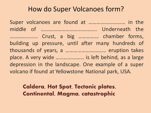
Mercalli scale, Richter scale, Super volcano
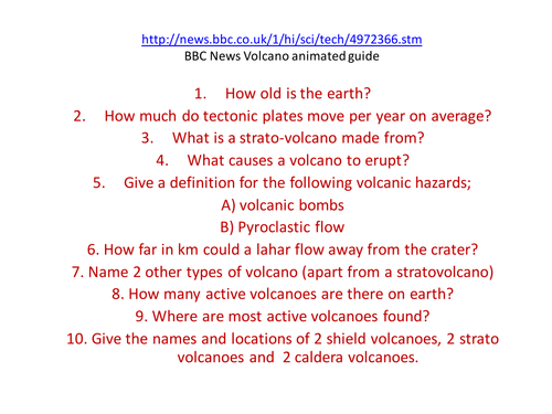
Full lesson with a starter recapping on how super volcanoes form (close passage/ gap fill) then moves on to look at how earthquakes are measured. A practical task on classifying earthqake damage by analysing video footage from youtube is included.
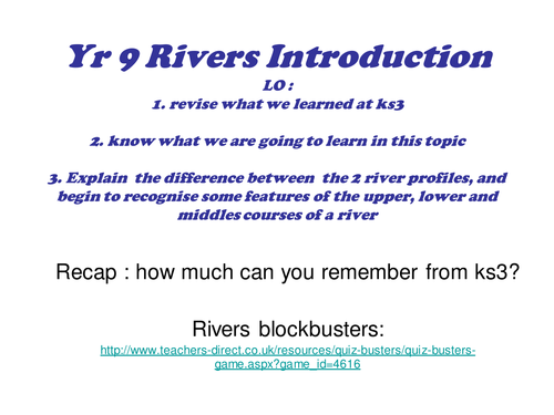
This is a full lesson introducing the water on the land topic. It covers a recap game from KS3, an overview of the course content from exam specification and some activities relating to the long and cross profile of a river. Can be used for other exam boards.
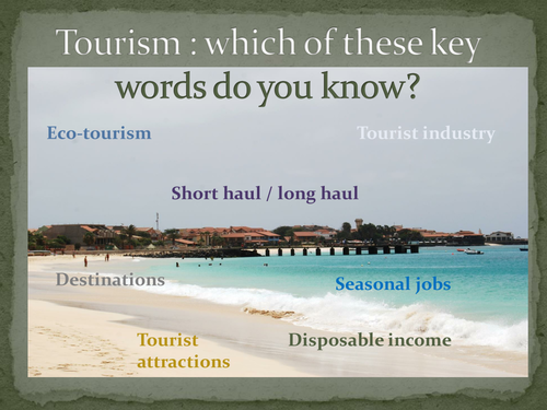
This is a levelled assessment task to review the learning of ks3 students on the topic of Tourism. The existing questions could easily be adapted to suit your scheme of work.
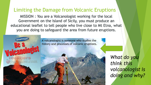
2 lessons on the eruptions of Mt Etna, focusing on the 1992 eruption. Lesson 1 examines the structure of a composite volcano and looks at the impacts of the eruption. Lesson 2 is about diaster planning for volcanic eruptions, specifically for this volcano.
This was done as part of my new Italy topic, and includes differentiated material. Specifically created for yr 8, but easily could be done with year 7. Lesson 2 needs Geog.1 books but it is not essential and could be substituded.
This FREE resource provides a comprehensive list of keywords that your students need to know and be able to define for the paper 3 Fieldwork and skills exam for GCSE Geography AQA specification. It may be applicable to other specifications also.
This introduction lesson on our year 7 topic ‘Pole to Pole’ / Cold climates looks at the climate and landscape features of the Tundra biome. Students analyse a climate graph to look at climatic features, and complete a differentiated reading comprehension exercise to pick ou features of the physical geography and landscape of the tundra. The rest of the 6 lesson on this mini scheme of work can be bought separately, or as a bundle for £8 from my tes shop, see resource entitled ’ Tundra Biome Year 7 SOW’
https://www.tes.com/teaching-resource/tundra-biome-year-7-sow-siberia-antarctica-12231148
During the nationwide corona virus lock-down this Spring I created this resource for fellow parents, struggling to home-tutor their kids whilst remotely working. Each of these Geography learning activities are simple, encourage a range of skills and does not require computer access. Most Primary school aged children should be able to complete relatively independently. please share widely.
Pinterest is a great search enguine and social media tool to use when you want to make something visual and create impact. I often find myself browsing creative Geography teaching ideas on here and so I thought I would put them together as a ‘board’ for you to pick and choose which ones might be fun ways to deliver geographical knowlege and understanding, with a fun, artistic twist. Almost all the resources on here are freely available to use, download or recreate with a range of ability and challenge levels for KS3 -KS4. These learning tasks can easily be used for home learning / home schooling, or in the classroom and outdoors. From origami cactus, making portraits with maps and using lego to build a soil profile, there is sure to be something for each class and learner.
Full lesson looking at the different properties of tectonic boundaries. Students extend and finish the mind map example based on the information provided in the powerpoint.
This structured talking exercise can take place between small groups of 2 or more people. Each person rolls 2 die to be directed to co-ordinates on a grid which lead to a question or discussion point. Most questions are intended to be reflective and make connections between geographical understanding at GCSE level ( years 9-11) and the current pandemic lockdown and social distancing measures. This encourages students to form opinions and make wider connections with their geographical knowledge. It is appropriate for a classroom, or distance /home based learning and could be done with a parent or carer.
Review slides recapping on how the following features are made:ask asks students to work in groups to produce a poster presentation to deliver to the class on one of the features
Graphs, maps and their analysis feature heavily in GCSE geography papers and examinations across all specifications. I put this handy wall display guide together to help my GCSE Geography students identify and describe the most common types of graphs and maps that they may see in the paper 3 examinations. It also gives a brief overview of the advantages and disadvantages of each type of display method- something students often struggle to articulate. It helped middle ability students picks up easy marks in their paper 3 fieldwork examinations and also made a great addition to classroom displays for open evenings and parent’s evenings. I hope you enjoy it!
As this is a FREE resource please consider buying a copy of my ebook ’ Time Smart Teaching; 8 Insider Tips that Schools Don’t tell you!
A pond is an example of a small-scale ecosystem that we typically student at GCSE Geography. Pond ecosystems depend on balance and equllibrium of all the interdependant parts that make it up; both the living ( biotic) and non-living ( abiotic). This lesson presumes you are lucky enough to have a pond on, or close to your school site to visit and carry out the field sketching tasks. However, if not, there is a detailed picture of a pond ecosystem on the slide they can copy if needed. Students start with a discussions, recap on producers, consumers and decomposers ( this lesson assumes a base-line understanding on food chains). Students sketch the pond with guidance and label appropriately using the mini-beasts spotter card to help them identify animals found on the pond, or through pond-dipping There is an exit card/ small write up task at the end.
A FREE home or classroom learning resource to get students familiar with a range of key vocabulary from the AQA GCSE Geography topic ’ Urban Issues and Challenges’. Urban areas include towns, cities and megacities that each have unique environmental and social challenges that need addressing in order to become more sustainable; pollution, poverty, education inequality and so on. This is a comprehensive list of keywords and their definitions to help build student confidence in applying specific key terms into exam practice questions on this topic. A full answer sheet is provided.
To help support th creation of FREE resources please consider grabbing a copy of my workload management book for Geography teachers ’ Time Smart Teaching; 8 insider tips to reduce workload that schools don’t tell you’. Click on the link below and FREE to subscribers of amazon
I have used my favourite Geography-themed inspirational quotes to design these cute minfullness colouring bookmarks as a simple, calming worksheets for KS2 Primary, KS3 secondary students. Also cab be used as a home schooling programme. Great to support a literacy in Geography initiative, or simply a relaxing end to a busy lesson or term. I designed these on Canva, and they come as a high quality PDF download.
please support me in my creation of FREE resources, by purchasing and reading my ebook for teachers ’ Time Smart Teaching’ available exclusively on Amazon:
This lesson includes simple tasks to work through and was designed for year 7 / 8 Geography at Ks3. The lesson focusses on the Geograhy of the North West England region to build up understanding in preparation for the GCSE Geography focus on the UK. Suitable for distance or remote learning.