

3k+Uploads
2189k+Views
2430k+Downloads
Geography
Bundle Sale

North American Countries KS2 Geography Knowledge Organisers Bundle!
These clear, detailed and visually-appealing resources offer a complete reference point for students revising knowledge relating to North American countries.
Included are knowledge organisers on the following countries:
Canada
Costa Rica
Cuba
Dominican Republic
El Salvador
Guatemala
Haiti
Honduras
Jamaica
Mexico
Panama
USA
Each organiser contains comprehensive sections on:
Overview and Maps;
Physical Geography;
Human Geography;
Comparison with the United Kingdom;
Country Timeline;
Key Vocabulary.
The organisers have been used in the past as a part of KS2 study of place, human and physical geography (‘understand geographical similarities and differences through the study of human and physical geography of a region of the United Kingdom…and a region of North America’).
They are designed to be printed onto A3, and is provided as both a PDF and a Word version (so that you can edit if you want to). All images used are licensed for commercial use and are cited on a separate document (included).
Bundle Sale

UK Countries Geography Knowledge Organisers Bundle!
These clear, detailed and visually-appealing resources offer a complete reference point for students revising knowledge relating to the countries of the United Kingdom, as a part of their study of place, human and physical geography. Each knowledge organiser contains comprehensive sections on:
Overview and Maps;
Physical Geography;
Human Geography;
Comparison with other countries of the United Kingdom;
Timeline;
Key Vocabulary.
There are 4 knowledge organisers in total:
-England
-Scotland
-Wales
-Northern Ireland
Each organiser is designed to help children to learn the relevant place, human and physical geography knowledge from the Geography National Curriculum:
-‘understand geographical similarities and differences through the study of human and physical geography of a region of the United Kingdom and a region in a European country’
-‘physical geography, including: climate zones, rivers, mountains, volcanoes and earthquakes’
-‘human geography, including: types of settlement and land use, economic activity including trade links, and the distribution of natural resources including energy.’
They are provided as both PDFs and Word versions (so that you can edit if you want to).
Bundle Sale

World Continents - Huge Bundle!
THIS HUGE BUNDLE CONTAINS ALL OF THE LESSONS, KNOWLEDGE ORGANISERS, AND GEOGRAPHICAL FEATURES INFORMATION SHEETS FOR EACH OF THE SEVEN CONTINENTS.
The lessons enable students to describe and understand the key aspects of physical geography (e.g. climates, vegetation belts, flora, fauna, mountains, and rivers) and human geography (e.g. types of settlement, populations, use of resources, and trade) for each of the different continents of the world.
Each lesson follows the same clear, logical, bite-size learning journey, which guides students towards relevant and constructive learning objectives. Students become able to:
-Identify the continent on a map, and identify the countries and regions within the continent;
-Understand key information about the physical and human geography of the continent, through a fun, interactive quiz;
-Retrieve, share, and describe their understanding of the physical and human geography of specific locations in the continent through comprehending information texts about the main geographical features;
-Complete case studies of the physical and human geography of a location of their choice in each continent, and describe their findings to others;
-Peer assess each others’ descriptions using the learning objectives.
This resource pack includes seven lessons (one for each continent), each containing:
-A visually engaging whole-lesson PowerPoint presentation;
-Key case-study information sheets on 4 geographical features of the continent;
-A blank case study template;
All images are licensed for commercial use.
These resources can be easily adapted to suit home/remote learning.
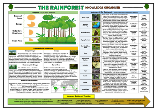
Rainforests KS2 Knowledge Organiser!
This clear, detailed and visually-appealing resource offers a complete reference point for students learning or revising knowledge relating to rainforests. It contains comprehensive sections on:
The different layers of the rainforest (emergent, canopy, understory/shrub, forest floor) and diagram;
Information about where rainforests can be found in the world;
Animals of the rainforest (including distribution, images, habitat, size/weight, and key facts);
Timeline of deforestation;
The resource is designed to be printed onto A3, and is provided as both a PDF and a Word version (so that you can edit if you want to). All images used are licensed for commercial use and are cited on a separate document (included). The resource is most suitable for students in KS2 or KS3.

Settlements - Geography Knowledge Organiser!
This clear, detailed and visually-appealing resource offers a complete reference point for students revising knowledge relating to settlements, as a part of their study of human geography. It contains comprehensive sections on:
-Overview;
-Types of Settlements (Isolated Homes, Hamlets, Villages, Towns, Cities and Megacities);
-Using Settlements Maps;
-Diagrams, Maps and Keys;
-Settlements in the UK;
-Key Vocabulary.
The organiser is designed to help children to learn the relevant human geography knowledge from the KS2 Geography National Curriculum, however it can be adapted for other age groups if necessary.
The resource is designed to be printed onto A3 or A4, and is provided as both a PDF and a Word version (so that you can edit if you want to). All images used are licensed for commercial use.

Population and Migration Knowledge Organiser/ Revision Mat!
This clear, detailed and visually-appealing resource offers a complete reference point for students learning or revising knowledge relating to the dinosaurs. It contains comprehensive sections on:
Overview - Population growth/decline and density/distribution;
Migration -Temporary/ permanent and voluntary/ forced;
Population growth in US and UK timelines;
Population Structures - young/emerging populations vs. ageing/declining populations;
Most populous countries and the populations of continents.
The resource is designed to be printed onto A3, and is provided as both a PDF and a Word version (so that you can edit if you want to). All images used are licensed for commercial use and are cited on a separate document (included).

Croatia Knowledge Organiser - KS2 Geography Place Knowledge!
This clear, detailed and visually-appealing resource offers a complete reference point for students revising knowledge relating to Croatia, as a part of their study of place, human and physical geography. It contains comprehensive sections on:
Overview and Maps;
Physical Geography;
Human Geography;
Comparison with the United Kingdom;
Croatia Timeline;
Key Vocabulary.
The organiser is designed to help children to learn the relevant place, human and physical geography knowledge from the KS2 Geography National Curriculum: -‘understand geographical similarities and differences through the study of human and physical geography of a region of the United Kingdom and a region in a European country’
‘physical geography, including: climate zones, rivers, mountains, volcanoes and earthquakes’
-‘human geography, including: types of settlement and land use, economic activity
including trade links, and the distribution of natural resources including energy.’
The resource is designed to be printed onto A3, and is provided as both a PDF and a Word version (so that you can edit if you want to). All images used are licensed for commercial use and are cited on a separate document (included).

Pointless - Geography 'Populations' Edition
Based on the popular game show 'Pointless', this resource is perfect for use as a starter activity, plenary, or revision tool. Editable, so that you can change to any other topic or change the questions/answers. Containing sound clips, engaging visuals, and suitably challenging questions, this resource is effective at both promoting engagement and enhancing learning.
There are several full rounds of questions to build students' understanding of populations, including:
- Naming the most populous countries in the world;.
- Defining key 'populations' terminology;;
- Unscrambling puzzles to identify populous regions;
- Thinking about the most densely populated places in a local area.
The nature of the game ensures that this resource can challenge students of all levels.
NOTE: You can buy this resource alone, or in a bundle of 8 Pointless games, for only £1 more!

Ukraine Knowledge Organiser - Geography Place Knowledge!
This clear, detailed and visually-appealing resource offers a complete reference point for students revising knowledge relating to Ukraine, as a part of their study of place, human and physical geography. It contains comprehensive sections on:
Overview and Maps;
Physical Geography;
Human Geography;
Comparison with the United Kingdom;
Ukraine Timeline;
Key Vocabulary.
The organiser is designed to help children to learn the relevant place, human and physical geography knowledge from the KS2 Geography National Curriculum: -‘understand geographical similarities and differences through the study of human and physical geography of a region of the United Kingdom and a region in a European country’
‘physical geography, including: climate zones, rivers, mountains, volcanoes and earthquakes’
-‘human geography, including: types of settlement and land use, economic activity
including trade links, and the distribution of natural resources including energy.’
The resource is designed to be printed onto A3, and is provided as both a PDF and a Word version (so that you can edit if you want to). All images used are licensed for commercial use and are cited on a separate document (included).

Place Knowledge - London - Knowledge Organiser!
This clear, detailed and visually-appealing resource offers a complete reference point for students learning or revising knowledge relating to London, as a part of their place knowledge in geography. It contains comprehensive sections on:
Overview;
Places/ Landmarks in London;
The River Thames;
Topography/ Highest Hills;
Human Geography Features;
Physical Geography Features;
Key Vocabulary.
The resource is designed to be printed onto A3, and is provided as both a PDF and a Word version (so that you can edit if you want to). All images used are licensed for commercial use and are cited on a separate document (included). The resource is aligned with the expectations of the geography national curriculum.

Rome - Capital Cities - Geography Knowledge Organiser!
This clear, detailed and visually-appealing resource offers a complete reference point for students learning or revising knowledge relating to Rome, as a part of their place knowledge of capital cities in geography. It contains comprehensive sections on:
Overview;
Places/ Landmarks in Rome;
Longest Rivers;
Topography/ Highest Mountains;
Human Geography Features;
Physical Geography Features;
Key Vocabulary.
The resource is designed to be printed onto A3, and is provided as both a PDF and a Word version (so that you can edit if you want to). All images used are licensed for commercial use and are cited on a separate document (included). The resource is aligned with the expectations of the geography national curriculum.

Tokyo - Capital Cities - Geography Knowledge Organiser!
This clear, detailed and visually-appealing resource offers a complete reference point for students learning or revising knowledge relating to Tokyo, as a part of their place knowledge of capital cities in geography. It contains comprehensive sections on:
Overview;
Places/ Landmarks in Tokyo;
Longest Rivers;
Topography/ Highest Mountains;
Human Geography Features;
Physical Geography Features;
Key Vocabulary.
The resource is designed to be printed onto A3, and is provided as both a PDF and a Word version (so that you can edit if you want to). All images used are licensed for commercial use and are cited on a separate document (included). The resource is aligned with the expectations of the geography national curriculum.

Human and Natural Disasters Knowledge Organiser - KS2 Geography!
This clear, detailed and visually-appealing resource offers a complete reference point for students revising knowledge relating to human and natural disasters, as a part of their study of both human and physical geography. It contains comprehensive sections on:
Overview;
How Earthquakes and Volcanoes Happen;
Human Disasters (Pollution, Deforestation, Industrial Accidents, Nuclear Radiation);
Natural Disasters (Earthquakes, Volcanic Eruptions, Hurricanes/ Tornadoes, Drought/ Flooding);
Disasters/ Timelines;
Key Vocabulary.
The organiser is designed to help children to learn the relevant human and physical geography knowledge from the KS2 Geography National Curriculum: ‘describe and understand key aspects of physical geography, including…volcanoes and earthquakes’ and ‘describe and understand key aspects of human geography, including…land use, economic activity…and distribution of natural resources.’
The resource is designed to be printed onto A3, and is provided as both a PDF and a Word version (so that you can edit if you want to). All images used are licensed for commercial use and are cited on a separate document (included).

Latitude and Longitude Knowledge Organiser - KS2 Geography!
This clear, detailed and visually-appealing resource offers a complete reference point for students revising knowledge relating to latitude and longitude, as a part of their study of locational knowledge in geography. It contains comprehensive sections on:
Overview;
Labelled Diagram;
Features of Latitude (Equator, Tropics of Cancer/Capricorn, Northern and Southern Hemispheres, and Arctic and Antarctic Circles);
Features of Longitude (Greenwich/ Prime Meridian and Time Zones);
Time Zones across the World;
Key Vocabulary.
The organiser is designed to help children to learn the relevant locational knowledge from the KS2 Geography National Curriculum: ‘identify the position and significance of latitude, longitude, Equator, Northern Hemisphere, Southern Hemisphere, the Tropics of Cancer and Capricorn, Arctic and Antarctic Circle, the Prime/Greenwich Meridian and time zones.’
The resource is designed to be printed onto A3, and is provided as both a PDF and a Word version (so that you can edit if you want to). All images used are licensed for commercial use and are cited on a separate document (included).

Antarctica - Human and Physical Geography (People and Places)
This interesting and highly-stimulating lesson enables students to describe and understand the key aspects of physical geography and human geography in the region of Antarctica. Whilst gaining a wide range of knowledge about the content, students also become familiar with a wide range of vocabulary pertinent to the geography curriculum.
The lesson follows a clear, logical, bite-size learning journey, which guides students towards relevant and constructive learning objectives. Over the course of this journey, they become able to:
Identify Antarctica on a map, and identify the countries and regions within the continent;
Understand key information about the physical and human geography of the continent, through a fun, interactive quiz;
Retrieve, share, and describe their understanding of the physical and human geography of specific locations in Antarctica (The South Pole, The Vinson Massif, Emperor Penguins and TheAntarctic Peninsula) through a jigsaw model task;
Complete a case study of the physical and human geography of their own place in Antarctica, and describe their findings to others;
-Peer assess each others’ descriptions using the learning objectives.
This resource pack includes:
A visually engaging whole-lesson PowerPoint presentation;
Key case-study information sheets on The South Pole, the Vinson Massif, Emperor Penguins and The Antarctic Peninsula (in both PDF and Word - inside the zip-folder);
A blank case study template.
All images are licensed for commercial use. Note: The final task works best with access to ICT/internet resources.
This resources within this lesson can be easily adapted to suit home/remote learning.

Democratic Republic of Congo Knowledge Organiser - Geography Place Knowledge!
This clear, detailed and visually-appealing resource offers a complete reference point for students revising knowledge relating to the Democratic Republic of Congo, as a part of their study of place, human and physical geography. It contains the following sections:
Overview and Maps;
Physical Geography;
Human Geography;
Comparison with the United Kingdom;
DRC Timeline;
Key Vocabulary.
The resource is designed to be printed onto A3, and is provided as both a PDF and a Word version (so that you can edit if you want to). All images used are licensed for commercial use and are cited on a separate document (included).

Asia: Physical and Human Geography (People and Places)
This interesting and highly-stimulating lesson enables students to describe and understand the key aspects of physical geography (e.g. climates, vegetation belts, flora, fauna, mountains, and rivers) and human geography (e.g. types of settlement, populations, use of resources, and trade) in the vast and varied continent of Asia. Whilst gaining a wide range of knowledge about the content, students also become familiar with a wide range of vocabulary pertinent to the geography curriculum.
The lesson follows a clear, logical, bite-size learning journey, which guides students towards relevant and constructive learning objectives. Over the course of this journey, they become able to:
- Identify Asia on a map, and identify the countries and regions within Asia;
- Understand key information about the physical and human geography of the continent, through a fun, interactive quiz;
- Retrieve, share, and describe their understanding of the physical and human geography of specific locations in Asia (Dubai, Yala National Park, Gobi Desert, and Tokyo) through a jigsaw model task;
- Complete a case study of the physical and human geography of their own place in Asia, and describe their findings to others;
-Peer assess each other’s descriptions using the learning objectives.
This resource pack includes:
- A visually engaging whole-lesson PowerPoint presentation;
- Key case-study information sheets on Dubai, the Gobi Desert, Yala National Park and Tokyo;
- A blank case study template;
- A detailed lesson plan, complete with what the teacher and students should aim to achieve at each stage of the lesson.
All images are licensed for commercial use, and are cited on the final slide of the PowerPoint. Note: The final task works best with access to ICT/internet resources.

Europe: Physical and Human Geography (People and Places)
This interesting and highly-stimulating lesson enables students to describe and understand the key aspects of physical geography (e.g. climates, vegetation belts, flora, fauna, mountains, and rivers) and human geography (e.g. types of settlement, populations, use of resources, and trade) in the continent of Europe. Whilst gaining a wide range of knowledge about the content, students also become familiar with a wide range of vocabulary pertinent to the geography curriculum.
The lesson follows a clear, logical, bite-size learning journey, which guides students towards relevant and constructive learning objectives. Over the course of this journey, they become able to:
Identify Europe on a map, and identify the countries and regions within the continent;
Understand key information about the physical and human geography of the continent, through a fun, interactive quiz;
Retrieve, share, and describe their understanding of the physical and human geography of specific locations in Europe (Scandinavia, The Mediterranean Sea, Mount Elbrus and the Black Forest) through a jigsaw model task;
Complete a case study of the physical and human geography of their own place in Europe, and describe their findings to others;
-Peer assess each others’ descriptions using the learning objectives.
This resource pack includes:
A visually engaging whole-lesson PowerPoint presentation;
Key case-study information sheets on Scandinavia, the Mediterranean Sea, Mount Elbrus and the Black Forest (in both PDF and Word - inside the zip-folder);
A blank case study template.
All images are licensed for commercial use. Note: The final task works best with access to ICT/internet resources.
This resources within this lesson can be easily adapted to suit home/remote learning.

Northern Ireland - Geography Knowledge Organiser!
This clear, detailed and visually-appealing resource offers a complete reference point for students revising knowledge relating to Northern Ireland, as a part of their study of place, human and physical geography. It contains comprehensive sections on:
Overview and Maps;
Physical Geography;
Human Geography;
Comparison with other UK Countries;
Northern Ireland Timeline;
Key Vocabulary.
The organiser is designed to help children to learn the relevant place, human and physical geography knowledge from the primary Geography National Curriculum: -‘understand geographical similarities and differences through the study of human and physical geography of a region of the United Kingdom and a region in a European country’
‘physical geography, including: climate zones, rivers, mountains, volcanoes and earthquakes’
-‘human geography, including: types of settlement and land use, economic activity
including trade links, and the distribution of natural resources including energy.’
The resource is designed to be printed onto A3, and is provided as both a PDF and a Word version (so that you can edit if you want to). All images used are licensed for commercial use and are cited on a separate document (included).

Kenya Knowledge Organiser - Geography Place Knowledge!
This clear, detailed and visually-appealing resource offers a complete reference point for students revising knowledge relating to Kenya, as a part of their study of place, human and physical geography. It contains the following sections:
Overview and Maps;
Physical Geography;
Human Geography;
Comparison with the United Kingdom;
Kenya Timeline;
Key Vocabulary.
The resource is designed to be printed onto A3, and is provided as both a PDF and a Word version (so that you can edit if you want to). All images used are licensed for commercial use and are cited on a separate document (included).