I've worked in primary teaching for over 10 years and specialise in creating fun and engaging educational resources, particularly for Geography and History.
I've worked in primary teaching for over 10 years and specialise in creating fun and engaging educational resources, particularly for Geography and History.
Understanding Latitude and Longitude is a Geography unit designed for students in upper KS2 and KS3.
The unit contains a sequence of four lessons which are carefully designed to help students understand the key concepts of latitude and longitude and learn the skill of reading coordinates on a world map.
The planning overview and topic title page can be downloaded for free here. Lessons include:
L1 – Introduction to latitude and longitude
L2 – Finding latitude and longitude coordinates on a world map
L3 – Reading latitude and longitude with greater accuracy
L4 – Locating world capital cities using latitude and longitude
Each lesson includes a presentation and differentiated activities/worksheets.
If you like this resource, we would appreciate a review! We will happily send you a free resource in return for a review or useful suggestions/feedback. Contact us at ed@teachitforward.co.uk.
Our World is a comprehensive Geography topic about Planet Earth, suitable for KS1 and lower KS2 (Y1-3).
The planning overview, topic title page and vocabulary page can be downloaded for free here. Lessons include:
L1 – Completing a world map jigsaw
L2 – Identifying the continents and oceans of the world (FREE)
L3 – Where do we live?
L4 – Identifying human and natural features of the world
L5 – Investigating satellite photos of famous world landmarks
L6 – Introduction to compass directions
L7 – Identifying world climate zones
L8 – Identifying the countries and capitals of the UK (FREE)
Each lesson includes a presentation and differentiated activities/worksheets.
If you like this resource, we would appreciate a review! We will happily send you a free resource in return for a review or useful suggestions/feedback. Contact us at ed@teachitforward.co.uk.
This resource is part of Tropical Rainforests, a Geography unit designed for students in KS2, but can also be taught as a stand alone lesson. All resources are compatible with both Microsoft Office and Google Workspace.
This lesson is a great introduction to the world’s largest rainforest, the Amazon. First, the presentation introduces students to the Amazon and its incredibly biodiverse flora and fauna. It then goes on to look at the geography of the Amazon in more detail, specifically its location within the continent of South America.
The activity challenges students to identify a range of human and physical geographical features within South America, including the nine countries in which the Amazon rainforest is located.
In follow up extension activities, students identify the capitals of those countries and then complete a cloze-procedure paragraph about the Amazon.
If you like this resource, we would appreciate a review! We will happily send you a free resource in return for a review or useful suggestions/feedback. Contact us at ed@teachitforward.co.uk.
This lesson is part of Exploring the United Kingdom, a Geography unit designed for KS1 and lower KS2 (Y2-4).
This lesson encourages students to identify geographical features found in the city/countryside and think about the similarities and differences between urban and rural areas in the UK.
First the presentation shows small segments of images from around the United Kingdom and challenges students to work out whether they are from the city or countryside.
Children then complete a Venn diagram-based activity which can be done in two ways:
Group activity:
In pairs or trios, children sort images of the city and countryside using a Venn diagram. This can also be done using two PE hoops and makes a nice classroom display.
Individual activity:
Students sort city and countryside vocabulary using a Venn diagram:
Easier – Students sort 12 city/countryside words
Harder – Students sort 18 city/countryside words
If you like this resource, we would appreciate a review! We will happily send you a free resource in return for a review or useful suggestions/feedback. Contact us at ed@teachitforward.co.uk.
This lesson is part of Mountain Environments, a Geography unit designed for students in upper KS2 (Y4-6).
N.B. Ideally students have a grounding in latitude and longitude prior to this lesson. The unit Understanding Latitude & Longitude is an ideal introduction to the topic.
First the presentation introduces students to latitude and longitude and goes through how to find the coordinates of a point step-by-step. It then asks students to find the latitude and longitude of several world capital cities.
The activity and extension then challenge children to locate famous world mountains using their latitude and longitude:
Easier - Students locate 12 famous world mountains using latitude and longitude.
Harder - Students locate 16 famous world mountains using latitude and longitude.
Extension - Students add more famous mountains to their world map using latitude and longitude clues.
If you like this resource, we would appreciate a review! We will happily send you a free resource in return for a review or useful suggestions/feedback. Contact us at ed@teachitforward.co.uk.
This lesson is designed for KS2 students and is a great introduction to any volcanoes or earthquakes topic. It can be taught as a stand alone lesson but is also available as part of three wider units, all of which are available on TES:
-Volcanoes
-Earthquakes
-Volcanoes & Earthquakes
The presentation investigates the structure of the Earth and looks into the basic composition of the inner core, outer core, mantle and crust.
Students then complete an activity which is differentiated three ways:
Easier – Students label layers of the Earth and complete cloze procedure paragraph (6 gaps).
Medium – Students label layers of the Earth and complete cloze procedure paragraph (10 gaps).
Harder – Students label layers of the Earth – including drawing arrows – and complete cloze procedure paragraph (10 gaps).
Extension – Students think about what they would like to find out about volcanoes or earthquakes or both, depending on which topic you are doing.
If you like this resource, we would appreciate a review! We will happily send you a free resource in return for a review or useful suggestions/feedback. Contact us at ed@teachitforward.co.uk.
This lesson is designed for KS2 children. It can be taught as a stand alone lesson but is also available as part of two wider units, both of which are available on TES:
-Earthquakes
-Volcanoes & Earthquakes
The presentation investigates the five deadly features of earthquakes including ground shaking, tsunamis, landslides, raising/lowering of land and liquefaction.
It is followed up by an activity which is differentiated four ways:
Easier – Students match pictures of the five features of an earthquake to descriptions.
Medium – Students complete cloze procedure sentences. They then match pictures to each description.
Harder – Students complete cloze procedure sentences. They then match pictures to each description and add a title for each section.
Hardest – Students stick pictures of the five features of an earthquake in their books and write their own description next to each one.
Extension – Can students unscramble the jumbled up earthquake facts?
If you like this resource, we would appreciate a review! We will happily send you a free resource in return for a review or useful suggestions/feedback. Contact us at ed@teachitforward.co.uk.
This lesson is part of The Seaside, a Geography unit designed for students in KS1 and lower KS2, but can also be taught as a stand alone lesson.
The presentation first explains the difference between human and physical geographical features. It then challenges students to identify a range of seaside features (e.g. cliffs, lighthouse, river mouth) and classify them as human or physical.
In the activity, students identify a range of seaside features and classify them as human or physical.
Easier - Students classify seaside features as human or physical.
Medium - Students label seaside features (with initial letter clues) and classify them as human or physical.
Harder - Students label seaside features (no clues) and classify them as human or physical.
Extension - Students unscramble sentences about the seaside.
If you like this resource, we would appreciate a review! We will happily send you a free resource in return for a review or useful suggestions/feedback. Contact us at ed@teachitforward.co.uk.
This lesson is part of Tropical Rainforests, a Geography unit designed for students in KS2, but can also be taught as a stand alone lesson. All resources are compatible with both Microsoft Office and Google Workspace.
First, the presentation introduces students to deforestation and then looks at the reasons the Amazon rainforest is being cut down (i.e. logging, farming and house building). Students are then encouraged to think about the positive and negative impacts of deforestation.
In the activity, students arrange these impacts of deforestation into a diamond 9, ranking them in terms of importance.
Easier - Students complete the diamond 9 and explain their reasoning for the most important statement they chose.
Harder - Students complete the diamond 9 and explain their reasoning for the most and least important statements they chose.
Extension - Students match topic words to their meanings.
If you like this resource, we would appreciate a review! We will happily send you a free resource in return for a review or useful suggestions/feedback. Contact us at ed@teachitforward.co.uk.
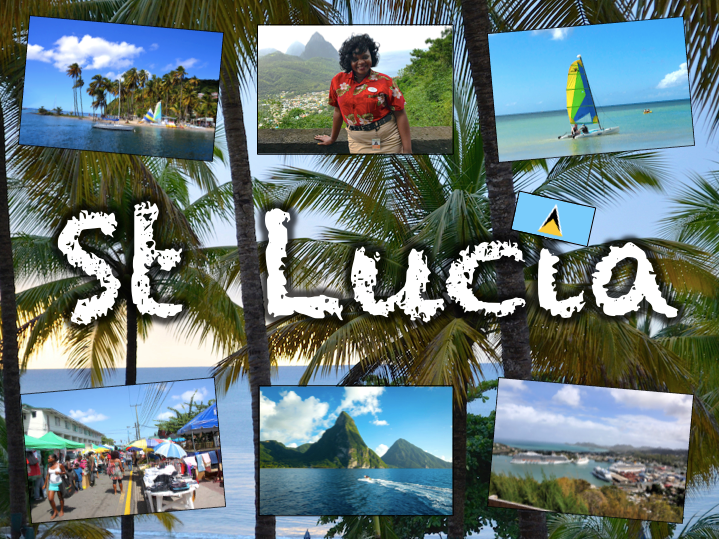
Exploring St Lucia is a Geography unit designed for students in KS2.
As a tropical island in the Caribbean, St Lucia is great for teaching about a contrasting non-European country.
The planning overview, topic title page and vocabulary page can be downloaded for free here. Lessons include:
L1 – Locating St Lucia in the Caribbean
L2 – Identifying the human and physical features of St Lucia
L3 – Investigating satellite photos of St Lucia
L4 – Using compass directions to locate places in St Lucia
L5 – Comparing the weather of St Lucia and the UK
L6 – Comparing St Lucia with the UK
Each lesson includes a presentation and differentiated activities/worksheets.
If you like this resource, we would appreciate a review! We will happily send you a free resource in return for a review or useful suggestions/feedback. Contact us at ed@teachitforward.co.uk.
Exploring Brazil is a Geography unit designed for students in KS2 (Y4-6).
The planning overview, topic title page and vocabulary page can be downloaded for free here. Lessons include:
L1 – Identifying the countries and capitals of South America
L2 – Writing a Brazil fact file
L3 – Using 4 and 6-figure grid references to locate Brazilian cities
L4 – Identifying the human and physical features of Brazil
L5 – Exploring Brazil’s ecosystems
L6 – Investigating Brazil’s weather and climate
Each lesson includes a presentation and differentiated activities/worksheets.
If you like this resource, we would appreciate a review! We will happily send you a free resource in return for a review or useful suggestions/feedback. Contact us at ed@teachitforward.co.uk.
This lesson is part of Exploring Spain, a Geography unit designed for upper KS2 students (Y4-6), but can also be taught as a stand alone lesson.
The presentation first recaps the climate zones of the world (i.e. tropical, temperate & polar zones) and locates Spain within these.
It then looks in more detail at Spain’s weather, climate zones and the climate of Madrid. Students are then encouraged to find clues about Madrid’s weather using a climate graph.
This lesson includes two activities:
Comprehension activity:
Students interpret climate graphs for Madrid and London and compare the climates of both cities.
ICT activity:
Students create their own climate graph for Madrid using Microsoft Excel.
If you like this resource, we would appreciate a review! We will happily send you a free resource in return for a review or useful suggestions/feedback. Contact us at ed@teachitforward.co.uk.
This lesson is part of The Seaside, a Geography unit designed for students in KS1 and lower KS2, but can also be taught as a stand alone lesson.
The presentation introduces students to the Isles of Scilly, which lie off the south-west coast of the UK. Students then get to find out what it’s like to live on an island with Zoe and Isaac, two children who live on Bryher.
The activity then challenges students to think about the differences between life on the Isles of Scilly and life on the mainland.
Easier - Students sort 8 statements describing life on the Isles of Scilly and life on the mainland.
Harder - Students sort 14 statements describing life on the Isles of Scilly and life on the mainland.
Extension - Can students think of their own statements to write in each column?
If you like this resource, we would appreciate a review! We will happily send you a free resource in return for a review or useful suggestions/feedback. Contact us at ed@teachitforward.co.uk.
This lesson is designed for KS2 students. It can be taught as a stand alone lesson but is also available as part of two wider units, both of which are available on TES:
-Volcanoes
-Volcanoes & Earthquakes
First the presentation locates the Caribbean island of Montserrat. It then looks in detail at the eruption of the Soufriere Hills volcano from 1995-99 and the devastating impact on the island.
There are two activities which accompany this lesson, plus extension activities:
Quiz Activity:
Video quiz activity which can be done in pairs/groups.
Writing Activity:
Students write a volcano fact file about the Soufriere Hills volcanic eruptions. This is differentiated three ways:
Easier – Students have statements to stick or copy into their fact file.
Medium – Students have a sequenced vocabulary prompt to scaffold their writing.
Harder – Students have an unsequenced vocabulary prompt to support their writing.
Extension – Students complete a cloze procedure text about the eruptions of Soufriere Hills.
If you like this resource, we would appreciate a review! We will happily send you a free resource in return for a review or useful suggestions/feedback. Contact us at ed@teachitforward.co.uk.
Exploring Australia is a comprehensive unit of lessons investigating Australia’s geography. It is designed for students in upper KS1 and lower KS2 (Y2-Y4).
A planning overview, topic title page and a knowledge organiser can be downloaded for FREE here.
The unit includes a variety of engaging lessons, differentiated activities, worksheets and a display pack. All resources are compatible with both Microsoft Office and Google Workspace.
All the resources described in this unit plan are available on TES, either as individual lessons or as a bundle. Lessons include:
L1 – Locating Australia on a world map
L2 – Identifying cities and states of Australia
L3 – Identifying human and physical features of Australia
L4 – Investigating satellite photos of Australian landmarks
L5 – Investigating Australia’s weather and climate
L6 – Comparing the UK and Australia
If you like this resource, we would appreciate a review! We will happily send you a free resource in return for a review or useful suggestions/feedback. Contact us at ed@teachitforward.co.uk.
This lesson is part of Exploring Brazil, a Geography unit designed for students in KS2 (Y4-6), but can also be taught as a stand alone lesson.
The presentation introduces students to Brazil’s six main biomes including the tropical rainforest, caatinga (desert), Pantanal wetlands, cerrado (savannah) and Atlantic Forest. Students then read an information text to find out more.
In the activity, students write an information text about Brazil’s ecosystems. This can either be done as a short activity or as an extended write in Literacy. (N.B. The activity sheets need to be enlarged to A3 size to provide adequate space for writing.)
Short Activity:
Easier – Students match statements to each ecosystem and write them in each box.
Medium – Students add titles, then match statements to each ecosystem and write them in each box.
Harder – Students add titles and write their own sentences about each ecosystem in the box.
Extension – Students label the different ecosystems on the map, including drawings of animals found in each one.
Extended Writing Activity:
Easier – Students write an information text about Brazil’s ecosystems, including an introductory paragraph.
Harder – Students write an information text about Brazil’s ecosystems, including sub-headings and an introductory paragraph.
If you like this resource, we would appreciate a review! We will happily send you a free resource in return for a review or useful suggestions/feedback. Contact us at ed@teachitforward.co.uk.
This lesson is part of Understanding Latitude and Longitude, a unit designed for students in upper KS2 and KS3. It can also be taught as a stand-alone lesson.
This lesson explains step-by-step how to find the coordinates of a point on a world map using lines of latitude and longitude.
In the activity, students are challenged to find the latitude and longitude of 12 points in all four quadrants of a world map. It is differentiated three ways:
Easier – Students find coordinates of 12 points in the NE, SE, SW and NW quadrants of the world map respectively. The compass directions are already filled in.
Medium – Students find coordinates of 12 points in the NE, SE, SW and NW quadrants of the world map respectively.
Harder – Students find coordinates of 12 points randomly distributed across the four quadrants of the world map.
Extension – Students are challenged to draw and label 4 more points on to their map.
If you like this resource, we would appreciate a review! We will happily send you a free resource in return for a review or useful suggestions/feedback. Contact us at ed@teachitforward.co.uk.
This lesson is part of Investigating Rivers, a unit designed for upper KS2 (Y4-6).
It investigates rainfall patterns in the UK and how flooding can occur when too much rain falls in a short period of time. Students also explore the consequences of too little rain – i.e. drought – and the effects this can have.
In the comprehension activity, students answer questions based on a text called ‘Floods and Droughts’. It is differentiated two ways:
Easier - Students answer standard comprehension questions.
Harder - Students answer trickier comprehension questions.
If you like this resource, we would appreciate a review! We will happily send you a free resource in return for a review or useful suggestions/feedback. Contact us at ed@teachitforward.co.uk.
This lesson is part of Exploring Spain, a Geography unit designed for upper KS2 students (Y4-6), but can also be taught as a stand alone lesson.
First the presentation covers key vocabulary (e.g. population, currency). It then locates Spain within Europe, asks students what they know about Spain and challenges them to think of ways to find out more.
There are two activities:
Research Activity:
Students research Spain using information sources (e.g. information books or suggested websites).
Easier – Students research famous landmarks, people, wildlife and Spanish food.
Harder – Students choose their own topics to research.
Extension: – Students draw pictures for each topic or find appropriate images online.
Writing Activity:
Students write a fact file using the information they have found.
Easier – Students write about famous landmarks, people, wildlife and Spanish food.
Harder – Students write about their own topics.
Extension – Students draw pictures or stick photos into the boxes for each topic.
If you like this resource, we would appreciate a review! We will happily send you a free resource in return for a review or useful suggestions/feedback. Contact us at ed@teachitforward.co.uk.
This lesson is part of Exploring Brazil, a Geography unit designed for students in KS2 (Y4-6), but can also be taught as a stand alone lesson.
The presentation first locates Brazil in the world’s climate zones and asks children to infer what the country’s weather and climate might be like.
Next, students look at three areas of Brazil in more detail – Manaus in the Amazon, Teresina in the caatinga desert region and Porto Alegre in the south of the country – and investigate a climate graph.
There are two activities:
Activity 1:
Students first investigate three climate graphs, looking at temperature and rainfall. Their challenge is to match each graph to an area of Brazil, explaining their reasoning for their choices. It is differentiated 2 ways:
Easier – Students match two statements to each climate graph, then match each graph to one of the three cities/regions.
Harder – Students write sentence describing the temperature and rainfall patterns in each climate graph, then match each graph to one of the three cities/regions.
Activity 2:
Students create their own Brazil climate graphs in Microsoft Excel using step-by-step instructions.
If you like this resource, we would appreciate a review! We will happily send you a free resource in return for a review or useful suggestions/feedback. Contact us at ed@teachitforward.co.uk.