Hero image

GeographyFocus Shop

Average Rating4.55
(based on 40 reviews)

I am a geography teacher with 36 years experience in Years 7 to 12 in high schools in New South Wales and Western Australia. I am now retired but maintain a strong interest in producing resources for the subject for which I have a passion. This shop features a range of geography resources suitable for upper primary school and high school. Free resources are available for you to use within your school to trial the quality of my work.

125Uploads

94k+Views

9k+Downloads

I am a geography teacher with 36 years experience in Years 7 to 12 in high schools in New South Wales and Western Australia. I am now retired but maintain a strong interest in producing resources for the subject for which I have a passion. This shop features a range of geography resources suitable for upper primary school and high school. Free resources are available for you to use within your school to trial the quality of my work.
Counties of England: East Midlands - word search and mapping exercise
swintrekswintrek

Counties of England: East Midlands - word search and mapping exercise

(0)
Wordsearches (a.k.a. word maze) are a fun way for your students to learn the counties of England’s East Midlands. The wordsearch is coupled with a map that encourages your students not only to learn the names of the counties but also their location. The puzzles have three levels of difficulty: Easy - Medium - Hard. This will allow you to differentiate according to the abilities of students in your class. Each of the three puzzles has its own answer key. A large map (A4 size) is also provided in the file should you need to use a larger map for your students rather than the smaller one provided in each word search. Altogether there are 7 pages in this file: 3 word searches, 3 answer keys, 1 A4 sized map.
Counties of England's north - wordsearch and mapping exercise
swintrekswintrek

Counties of England's north - wordsearch and mapping exercise

(0)
Wordsearches (a.k.a. word maze) are a fun way for your students to learn the counties of England’s north (Northwest, Northeast and Yorkshire and the Humber. The wordsearch is coupled with a map that encourages your students not only to learn the names of the counties but also their location. The puzzles have three levels of difficulty: Easy - Medium - Hard. This will allow you to differentiate according to the abilities of students in your class. Each of the three puzzles has its own answer key. A large map (A4 size) is also provided in the file should you need to use a larger map for your students rather than the smaller one provided in each word search. Altogether there are 7 pages in this file: 3 word searches, 3 answer keys, 1 A4 sized map.
Counties of England's West Midlands - word search and mapping exercise
swintrekswintrek

Counties of England's West Midlands - word search and mapping exercise

(0)
Wordsearches (a.k.a. word maze) are a fun way for your students to learn the counties of England’s East Midlands. The wordsearch is coupled with a map that encourages your students not only to learn the names of the counties but also their location. The puzzles have three levels of difficulty: Easy - Medium - Hard. This will allow you to differentiate according to the abilities of students in your class. Each of the three puzzles has its own answer key. A large map (A4 size) is also provided in the file should you need to use a larger map for your students rather than the smaller one provided in each word search. Altogether there are 7 pages in this file: 3 word searches, 3 answer keys, 1 A4 sized map.
Hurricane Michael - October 2018 (a geographical enquiry)
swintrekswintrek

Hurricane Michael - October 2018 (a geographical enquiry)

(0)
This is a worksheet (3 pages) that will get your students to investigate Hurricane Michael (October 2018). The first page is a latitude and longitude exercise where the students will be the meteorologist and map the track of the hurricane from its beginning in the waters of the Yucatan Peninsula to its arrival at the Florida Panhandle. On the second page students will answer general questions on hurricanes as background to the third page where they will look at the impact of Hurricane Michael more closely. The worksheet is best suited for lower high school but could be used at a higher level. An answer sheet is provided for teachers as a separate file.
Mountain Landscapes - the Seven Summits Challenge
swintrekswintrek

Mountain Landscapes - the Seven Summits Challenge

(0)
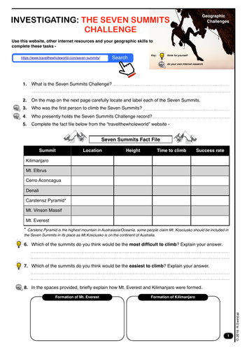
A mountain landscapes worksheet that requires students to investigate the “7 Summits Challenge” and in doing so identify the highest mountains on each continent and locate them on the world map on the second page. A useful worksheet for the Landscapes and Landforms unit in the Australian Curriculum and in other jurisdictions where mountain landscapes are included in their curricula. Worksheet is pitched at lower high school level.
US Climate Graph Construction
swintrekswintrek

US Climate Graph Construction

(0)
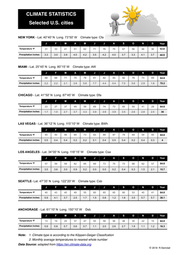
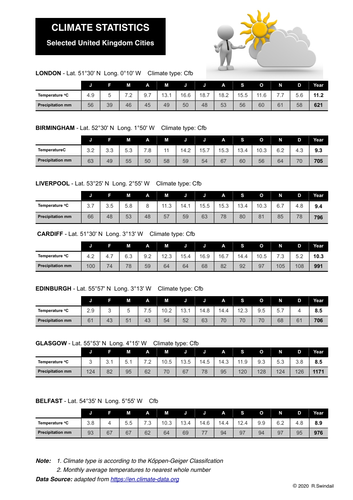
Three pages - first page is a table of climate statistics (temperature in fahrenheit, precipitation in inches) for seven US cities with different climate classification; second page is a worksheet for student to use the climate statistics to draw climate graphs for each city and to locate them on a map of the U.S.; third page is an answer key with graphs drawn and cities located on the map of the U.S.
Water in the World: the value of water to different cultures
swintrekswintrek

Water in the World: the value of water to different cultures

(0)
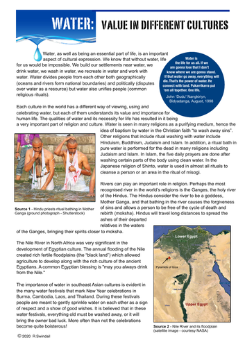
One page of text explaining the value of water to different cultures followed by three learning activities that require students to answer questions based on the text, use provided websites to investigate the significance of rivers to different cultures, and finally to investigate the value of water to Australian Aboriginal groups.
Hurricane Dorian Enquiry
swintrekswintrek

Hurricane Dorian Enquiry

(0)
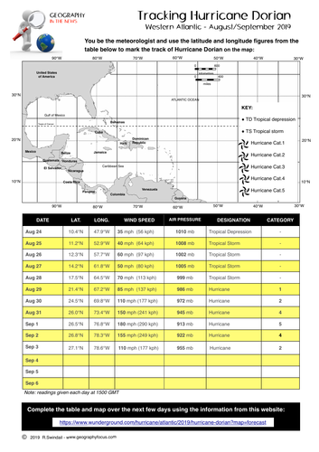
An enquiry into Hurricane Dorian August/September 2019. Students use latitude and longitude to track the path of Hurricane Dorian, investigate hurricanes in general and the impact of Hurricane Dorian on the Bahamas. An answer key is provided.
Water in the World: Water as a Resource
swintrekswintrek

Water in the World: Water as a Resource

(0)
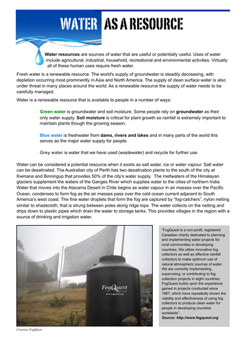
Five pages: first page is text on water as a resource with the other four pages learning activities that ask students to investigate the use of water as a resource. Produced for the Australian Curriculum Geography topic “Water in the World”. May also be useful in other jurisdictions where water is part of the geography curriculum.
Tropical Cyclone Harold Enquiry
swintrekswintrek

Tropical Cyclone Harold Enquiry

(0)
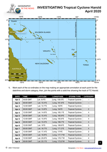
This is a worksheet (4 pages) that will get your students to investigate Tropical Cyclone (April 2020). The first page is a latitude and longitude exercise where the students will be the meteorologist and map the track of the tropical cyclone from its beginning in the waters off Papua New Guinea to its passing the Pacific island of Tonga. On the second to fourth pages students will answer general questions on tropical cyclones and specific set of research questions on TC Harold. An answer key is provided
Extreme Weather Event: South Australia - Supercell storms 28th and 29th September 2016
swintrekswintrek

Extreme Weather Event: South Australia - Supercell storms 28th and 29th September 2016

(0)
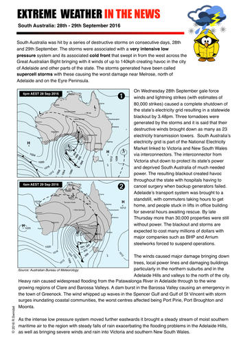
A one page summary sheet and three pages of worksheets based on a series of supercell storms that hit South Australia over the period 28th to 29th September 2016. The summary sheet includes two synoptic charts from the period and text description of the intense low pressure system and associated cold front that hit South Australia- Worksheet 1 asks students general questions based on the two synoptic charts - Worksheet 2 asks questions directly related to the extreme weather event, its causes and impacts which included a statewide collapse of the electricity grid. An answer key is provided for teachers.
Extreme weather event - Cold front eastern Australia June 2021
swintrekswintrek

Extreme weather event - Cold front eastern Australia June 2021

(0)
This worksheet is an extreme weather case study that gets students to investigate a cold front that impacted the eastern seaboard of Australia on 9th June 2021 causing an immense amount of property damage, widespread snowfall/rain and flooding in the hinterland. Students are taken to the Australian Bureau of Meteorology’s website where they will be able to obtain information about cold fronts and an Australian news’ website where they will get information of the impact of this extreme weather event. Three pages in the worksheet. An answer key is provided.
Climate Statistics and Climate Graphs for Asian Cities
swintrekswintrek

Climate Statistics and Climate Graphs for Asian Cities

(0)
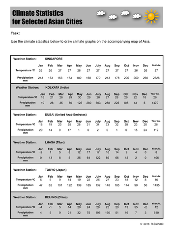
A three page set that provides climate statistics for six Asian cities, a page where students can draw the climate graphs from the statistics (includes six climate graph blanks and a location map for the cities) and a third page with completed climate graphs for teachers . The cities are: Kolkata, Lhasa, Beijing, Singapore, Tokyo and Dubai.
GEOGRAPHY IN THE NEWS weekly quiz - January 1st 2024
swintrekswintrek

GEOGRAPHY IN THE NEWS weekly quiz - January 1st 2024

(0)
This is a free download of the first issue of Geography in the News in 2024. Please download and trial it with your classes. A new quiz is published on Sunday each week based on news of the previous week and available from this site for only £1 for each issue. Geography in the News is based on current news from a geographic perspective. This quiz will suit students from upper primary school to upper high school. ​ The quiz has two pages with five mapping questions and 15 multiple choice questions - answers are given in the second pdf download. ​ The quiz is a PDF that you can download and print for your classes. The quiz is coloured but will photocopy well as b/w. ​ How are schools using Geography in the News? As a quiz that can be completed in as little as 6 minutes. Group research. As homework exercises that students can research the answers from a range of news websites. Weekly group competitions within the class over a term or the year. Weekly school geography competitions to promote the subject. As a discussion starter. ​ In whatever way Geography in the News is being used it has been seen to engage students in Geography and improve their geographic knowledge by taking them beyond the classroom. ​ **A weekly version of the Geography In The News quiz for Australian schools is available from my Geography Focus website. IF YOU AND YOUR STUDENTS ARE ENJOYING THIS QUIZ SPREAD THE WORD ABOUT IT BY TELLING COLLEAGUES AT OTHER SCHOOLS
Topographic Map Skills 11 - Gradient
swintrekswintrek

Topographic Map Skills 11 - Gradient

(0)
A handout on developing topographic maps skills that focuses on gradient. Also available at a vastly reduced price in a bundle of all topographic mapping skills plus 10 graded exercises (with answers)
Where in the World? - a latitude/longitude exercise
swintrekswintrek

Where in the World? - a latitude/longitude exercise

(0)
This is a latitude and longitude exercise that requires students to find the places indicated by latitude and longitude using the website given in the worksheet OR an atlas. A blank world map is also provided to allow the students to accurately locate and label the places using the latitude and longitude grid. Answers are provided for the benefit of teachers.
Investigating Plate Tectonics
swintrekswintrek

Investigating Plate Tectonics

(0)
This worksheet requires students to investigate the basic ideas behind plate tectonics by looking at the website given in the worksheet. They will be required to answer the questions and complete simple diagrams on the worksheet that are available on the website. Finally they are given three questions at the end of the second page to prepare for a discussion in class - questions are not shown in the preview, but they are: 1. If your school was located towards the middle of a tectonic plate would this have implications for you? YES/NO. Explain your answer. 2. If your school was located near the edge of a tectonic plate what natural hazards could you be affected by? 3. How could you prepare for these hazards?
Where in Europe? - a latitude/longitude exercise
swintrekswintrek

Where in Europe? - a latitude/longitude exercise

(0)
This is a latitude and longitude exercise that requires students to find capital cities of Europe indicated by latitude and longitude using the website given in the worksheet OR an atlas. A blank map of Europe is also provided to allow the students to accurately locate and label the places using the latitude and longitude grid. Answers are provided for the benefit of teachers.