Thank you for visiting! Here you will find a selection of printable, interactive worksheets for your classroom: Basic Geography worksheets with simple maps, ESL, Spanish, Bible, Reading Comprehension and more. I hope you find the resources useful! Reviews are welcome and very much appreciated. Thank you so much.
Thank you for visiting! Here you will find a selection of printable, interactive worksheets for your classroom: Basic Geography worksheets with simple maps, ESL, Spanish, Bible, Reading Comprehension and more. I hope you find the resources useful! Reviews are welcome and very much appreciated. Thank you so much.
Introduce your students to Belgium with this printable handout of two worksheets (plus answer key). Your students will read a brief introduction to Belgium (location, capital, flag, language), write ‘Brussels’ next to the star on the map to show the capital, color the small flag and map, and use the map and compass to answer 7 questions on page 2. Colored pencils and a pen or pencil are needed for this activity. No other pep needed. Basic Geography worksheet with a simple map to introduce Belgium and practice cardinal and ordinal directions.
For use with Interactive Notebooks: After the worksheets are completed, students can cut out the map and flag and paste into the notebook under the topic of Europe/Sub-Topic: Belgium. Under the map and flag, students can write a summary in their own words of what they now know about this country. Collect worksheets for other countries of Europe to add to the notebook! All available in this store! Please browse this store for a selection of worksheets for other countries of Europe (and beyond!).
Thank you so much for using my Geography worksheets in your classroom! I hope you find them useful. Reviews are welcome and very much appreciated!
Introduce your students to the country of MONACO with two worksheets (plus answer key). Your students will read an introduction to Monaco (location, capital, flag, language), write ‘Monte Carlo’ next to the star on the map to show the location of the capital, color a small map and flag, and use the map and compass to answer 6 multiple-choice questions on page 2. Colored pencils and a pen or pencil are needed for this activity. No other prep needed. Basic Geography worksheet with a simple map to introduce the country of Monaco and practice cardinal and ordinal directions.
For use with Interactive Notebooks: After completing the worksheets, students can cut out the map and flag and paste into the notebook under the topic of Europe / Sub-Topic: Monaco. Under the map and flag, students can write a summary in their own words of what they now know about this country. Collect worksheets for other countries of Europe to add to the notebook! Please browse this store for a selection of worksheets for other countries of Europe (and beyond!)
Thank you so much for using my Geography worksheets in your classroom! I hope you find them useful. Reviews are welcome and very much appreciated!
Introduce your students to VATICAN CITY with this printable handout of two worksheets (plus answer key). Your students will read a brief introduction to Vatican City, color a small map, and use the map and compass to answer 6 multiple-choice questions on page 2. Colored pencils and a pen or pencil are needed for this activity. No other prep needed. Included on map: Rome, Italy and Vatican City: St. Peter’s Basilica, St. Peter’s Square, Vatican Palace.
For use with Interactive Notebooks: After completing the worksheets, students can cut out the map of Vatican City and paste into the notebook under the topic of Europe / Sub-Topic: Vatican City. Under the map and flag, students can write a summary in their own words of what they now know about Vatican City. Collect worksheets for other countries of Europe to add to the notebook! Please browse this store for a selection of worksheets for other countries of Europe (and beyond!).
Thank you so much for using my Geography worksheets in your classroom! I hope you find them useful and fun. Reviews are welcome and very much appreciated!
Introduce your learners to Bulgaria in Europe with two printable worksheets (plus answer key). Your students will read a brief introduction to Bulgaria (location, capital, flag, language), write ‘Sofia’ next to the star on the map to show the location of the capital, color the small map and flag, and use the map and compass to answer 6 questions on page 2. Colored pencils and a pen or pencil are needed for this activity. No other prep needed. Basic Geography worksheet with a simple map to introduce Bulgaria and practice cardinal and ordinal directions.
For use with Interactive Notebooks: After completing the worksheets, students can cut out the map and flag and paste into the notebook under the topic of Europe/Sub-Topic: Bulgaria. Under the map and flag, students can write a summary in their own words of what they now know about this country. Collect worksheets for other countries of Europe to add to the notebook! All available in this store! Please browse this store for a selection of worksheets for other countries of Europe (and beyond!)
Thank you so much for using my Geography worksheets in your classroom. I hope you find them useful. Reviews are welcome and very much appreciated!
Included: North Macedonia, Greece, Turkey, Romania, Serbia, Black Sea, Aegean Sea, Sea of Marmara
Introduce your students to the country of SOUTH AFRICA with two worksheets (plus answer key). Your students will read a brief introduction to South Africa (location, capitals, flag, language), write ‘Pretoria’ next to the ‘A’ on the map to show the administrative capital; write ‘Bloemfontein’ next to the ‘J’ to show the judicial capital; write ‘Cape Town’ next to the ‘L’ on the map to show the legislative capital, color the small map, and use the map and compass to answer 9 questions on page 2. Basic Geography Worksheet with a simple map to introduce South Africa and practice cardinal and ordinal directions. Colored pencils and a pen or pencil are needed for this activity.
For use with Interactive Notebooks: After the worksheets are completed, students can cut out the map and flag and paste into the notebook under the topic of Africa / Sub-Topic: South Africa. Under the map, students can write a summary in their own words of what they now know about this country. Collect worksheets for other countries of Africa to add to the notebook! Please browse this store for a selection of worksheets for other countries of Africa (and beyond!).
Thank you so much for using my Geography worksheets in your classroom! I hope you find them useful. Reviews are welcome and very much appreciated.
Introduce your students to ISRAEL with this printable handout of two worksheets (plus answer key). Your students will read a brief introduction to Israel (location, capital, flag, language), write ‘Jerusalem’ next to the star on the map to show the location of the capital, color the small map, and use the map and compass to answer 9 questions on page 2. Colored pencils and a pen or pencil are needed for this activity. No other prep needed. Basic Geography worksheet with a simple map to introduce Israel and practice cardinal/ordinal directions.
For use with Interactive Notebooks: After the worksheets are completed, students can cut out the map and flag and paste into the notebook under the topic of Asia / Sub-topic: Israel. Under the map and flag, your students can write a summary in their own words of what they now know about Israel. Collect handouts for other countries of Asia to add to the notebook! Please browse this store for a selection of worksheets for all other countries of Asia (and beyond)!
Thank you so much for using my Geography worksheets in your classroom! I hope you find them useful. Reviews are welcome and very much appreciated.
Included: Mediterranean Sea, Red Sea, Dead Sea, Holy Land, Lebanon, Syria, Jordan, Egypt, Saudi Arabia, Tel Aviv, Bethlehem, Nazareth, Palestinian territories West Bank and Gaza, Star of David, Tallit.
Introduce your students to Uganda with two worksheets (plus answer key). Your students will read a brief introduction to Uganda (location, capital, flag, language), write ‘Kampala’ next to the star on the map to show the location of the capital, color the small map, and use the map and compass to answer 8 questions on page 2. Colored pencils and a pen or pencil are needed for this activity. No other prep needed. Basic Geography worksheet with a simple map to introduce the country of Uganda and practice cardinal/ordinal directions.
For use with Interactive Notebooks: After the worksheets are completed, students can cut out the map and flag and paste into the notebook under the topic of Africa / Sub-topic: Uganda. Under the map and flag, your students can write a summary in their own words of what they now know about this country. Collect worksheets for other countries of Africa to add to the notebook! Please browse this store for a selection of worksheets for other countries of Africa (and beyond!).
Thank you so much for using my Geography worksheets in your classroom! I hope you find them useful. Reviews are welcome and very much appreciated!
Introduce your students to the country of Andorra with this printable handout of two worksheets (plus answer key). Your students will read a brief introduction to Andorra (location, capital, flag, language), write ‘Andorra la Vella’ next to the star on the map to show the location of the capital, color the small map, and use the map and compass to answer 7 multiple-choice questions on page 2. Colored pencils and a pen or pencil are needed for this activity. No other prep needed. Basic Geography worksheet with a simple map to introduce Andorra and practice cardinal and ordinal directions. Reading comprehension strategies.
For use with Interactive Notebooks: After the worksheets are completed, students can cut out the map and flag and paste into the notebook under the topic of Europe / Sub-Topic: Andorra. Under the map and flag, students can write a summary in their own words of what they now know about this country. Collect worksheets for other countries of Europe to add to the notebook! Worksheets for all countries of Europe are available in this store. Please browse this store for a selection of worksheets for other countries of Europe (and beyond!).
Thank you so much for using my Geography worksheets in your classroom! I hope you find them useful. Reviews are welcome and very much appreciated!
Introduce your students to Ethiopia with two worksheets (plus answer key). Your students will read a brief introduction to Ethiopia (location, capital, flag, language), write ‘Addis Ababa’ next to the star on the map to show the location of the capital, color the small map, and use the map and compass to answer 8 questions on page 2. Colored pencils and a pen or pencil are needed for this activity. No other prep needed. Basic Geography worksheet includes a simple map to introduce the country of Ethiopia and practice cardinal/ordinal directions.
For use with Interactive Notebooks: After the worksheets are completed, students can cut out the map and flag and paste into the notebook under the topic of Africa / Sub-topic: Ethiopia. Under the map and flag, your students can write a summary in their own words of what they now know about Ethiopia. Collect worksheets for other countries of Africa to add to the notebook! Please browse this store for worksheets for other countries of Africa (and beyond!).
Thank you so much for using my Geography worksheets in your classroom! I hope you find them useful. Reviews are welcome and very much appreciated!
Introduce your students to TANZANIA with two worksheets (plus answer key). Your students will read a brief introduction to Tanzania (location, capital, flag, language), write ‘Dodoma’ next to the star on the map to show the location of the capital, color the small map, and use the map and compass to answer 9 questions on page 2. Colored pencils and a pen or pencil are needed for this activity. No other prep needed. Basic Geography worksheet with a simple map to introduce the country of Tanzania and practice cardinal/ordinal directions.
For use with Interactive Notebooks: After the worksheets are completed, students can cut out the map and flag and paste into the notebook under the topic of Africa / Sub-topic: Tanzania. Under the map and flag, your students can write a summary in their own words of what they now know about this country. Collect worksheets for other countries of Africa to add to the notebook! Please browse this store for a selection of worksheets for other countries of Africa (and beyond!).
Thank you so much for using my Geography worksheets in your classroom! I hope you find them useful. Reviews are welcome and very much appreciated!
Introduce your learners to MADAGASCAR in Africa with two worksheets (plus answer key). Your students will read a brief introduction to Madagascar (location, capital, flag, language), write ‘Antananarivo’ next to the star on the map to show the location of the capital, color the small map, and use the map and compass to answer 6 multiple-choice questions on page 2. Colored pencils and a pen or pencil are needed for this activity. No other prep needed. Basic Geography worksheet with a simple map to introduce the country of Madagascar and practice cardinal/ordinal directions.
For use with Interactive Notebooks: After the worksheets are completed, students can cut out the map and flag and paste into the notebook under the topic of Africa / Sub-topic: Madagascar. Under the map and flag, your students can write a summary in their own words of what they now know about this country. Collect worksheets for other countries of Africa to add to the notebook! All available in this store!
Thank you so much for using my Geography worksheets in your classroom! I hope you find them useful. Reviews are welcome and very much appreciated! Please browse this store for worksheets to introduce your learners to all countries of Africa and the world!
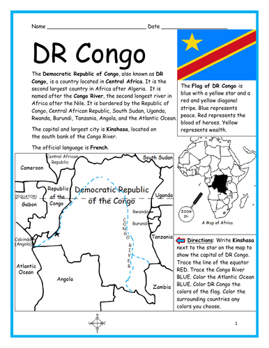
Introduce your students to the Democratic Republic of Congo (DR Congo) with this printable handout of two worksheets (plus answer key). Your students will read a brief introduction to DR Congo (location, capital, flag, language), write ‘Kinshasa’ next to the star on the map to show the capital, trace the lines to show the location of the equator and Congo River, color the small map, and use the map and compass to answer 9 questions on page 2. Colored pencils and a pen or pencil are needed for this activity. No other prep needed. Basic Geography worksheet with a simple map to introduce DR Congo and practice cardinal and ordinal directions.
For use with Interactive Notebooks: After the worksheets are completed, students can cut out the map and flag and paste into the notebook under the topic of Africa/Sub-topic: DR Congo. Under the map and flag, your students can write a summary in their own words of what they now know about this country. Collect handouts for other countries of Africa to add to the notebook! Please browse this store for a selection of printable worksheets for other countries of Africa (and beyond!).
Thank you so much for using my Geography worksheets in your classroom! I hope you find them useful! Reviews are welcome and very much appreciated!
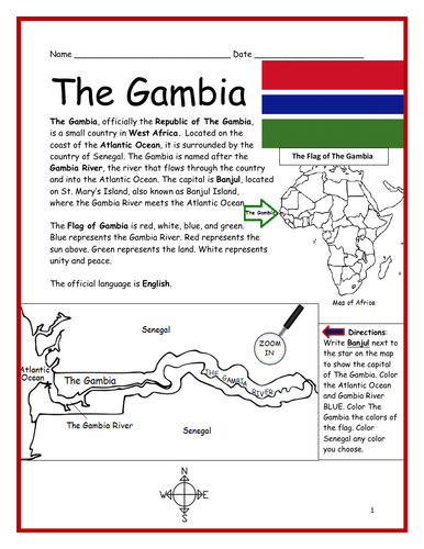
Introduce your students to THE GAMBIA in Africa with this printable handout of two worksheets (plus answer key). Your students will read a brief introduction to The Gambia (location, capital, flag, language), write ‘Banjul’ next to the star on the map to show the capital, color the small map, and use the map and compass to answer 7 questions on page 2. Colored pencils and a pen or pencil are needed for this activity. No other prep needed. Basic Geography worksheet includes a simple map to introduce The Gambia and practice cardinal/ordinal directions.
For use with Interactive Notebooks: After the worksheets are completed, students can cut out the map and flag and paste into the notebook under the topic of Africa/Sub-topic: The Gambia. Under the map and flag, your students can write a summary in their own words of what they now know about this country. Collect handouts for other countries of Africa to add to the notebook! Please browse this store for a selection of printable Geography worksheets for other countries of Africa (and beyond!).
Thank you so much for using my Geography worksheets in your classroom! I hope you find them useful. Reviews are welcome and very much appreciated!
Introduce your students to the country of SOUTH SUDAN in Africa with this printable handout of two worksheets (plus answer key). Your students will read a brief overview of South Sudan (location, capital, flag, language), write ‘Juba’ next to the star on the map to show the capital, trace the line of White Nile, color the small map, and use the map and compass to answer 9 questions on page 2. Colored pencils and a pen or pencil are needed for this activity. No other prep needed. Basic Geography worksheet includes a simple map to introduce South Sudan and practice cardinal/ordinal directions.
For use with Interactive Notebooks: After the handout is completed, students can cut out the map and flag and paste into the notebook under the topic of Africa/Sub-topic: South Sudan. Under the map and flag, your students can write a summary in their own words of what they now know about this country. Collect handouts for other countries of Africa to add to the notebook! Please browse this store for a selection of printable handouts for other countries of Africa (and beyond!).
Thank you so much for using my Geography worksheets in your classroom!
Included on this map: Sudan, Ethiopia, Kenya, Uganda, DR Congo, CAR, disputed territories Abyei Area and Ilemi Triangle. South Sudan gained independence from Sudan in 2011.
Introduce your students to the country of ANGOLA in Africa with this printable handout of two worksheets (plus answer key). Your students will read a brief introduction to Angola (location, capital, flag, language), write ‘Luanda’ next to the star on the map to show the capital, color the small map, and use the map and compass to answer 8 questions on page 2. Colored pencils and a pen or pencil are needed for this activity. No other prep needed. Basic Geography worksheet with a simple map to introduce Angola and practice cardinal/ordinal directions.
For use with Interactive Notebooks: After the worksheets are completed, students can cut out the map and flag and paste into the notebook under the topic of Africa/Sub-topic: Angola. Under the map and flag, your students can write a summary in their own words of what they now know about this country. Collect worksheets for other countries of Africa to add to the notebook! Please browse this store for a selection of printable worksheets for all other countries of Africa (and beyond!).
Thank you so much for using my Geography worksheets in your classroom! I hope you find them useful. Reviews are welcome and very much appreciated!
Using the map of the island of Hispaniola, find the countries, capitals, islands and surrounding in the Word Search Puzzle: HAITI, DOMINICAN REPUBLIC, PORT-AU-PRINCE, SANTO DOMINGO, SAONA ISLAND, BEATA ISLAND, TORTUGA ISLAND, GONAVE ISLAND, LES CAYEMITES, ILE-A-VACHE ISLAND, ATLANTIC OCEAN, CARIBBEAN SEA, CUBA. Then write the remaining letters below to spell out a fact about the island of Hispaniola! The remaining letters will spell out the following: When Christopher Columbus landed on this island of Hispaniola in 1492, he named it La Isla Espanola, which means The Spanish island.
Answer key included.
Thank you for using my worksheets in your classroom! Please browse this store for more Geography worksheets and Word Search Puzzles.
Introduce your learners to United Arab Emirates in the Middle East and Asia with this printable handout of two worksheets (plus answer key). Your students will read a brief introduction to UAE (location, capital, language, flag), write ‘Abu Dhabi’ next to the star on the map to show the location of the capital, color the small map, and use the map and compass to answer 9 questions on page 2. Colored pencils and a pen or pencil are needed for this activity. No other prep needed. Basic Geography worksheet with a simple map to introduce UAE and practice cardinal/ordinal directions.
For use with Interactive Notebooks: After your students complete the worksheets, they can cut out the map and flag of UAE and paste into the notebook under the topic of Asia or Middle East / Sub-topic: United Arab Emirates. Under the map, students can write a summary in their own words of what they now know about this country. Collect worksheets for other countries of Asia or the Middle East to add to the notebook! All available in this store. Please browse this store for a selection of printable worksheets for other countries of Asia, the Middle East, and beyond!
Thank you so much for using my Geography worksheets in your classroom! I hope you find them useful. Reviews are welcome and very much appreciated.
Included: Persian Gulf, Gulf of Oman, Arabian Peninsula, maritime borders, Arabic, Pan-Arab colors, 7 emirates
Introduce your learners to the state of MISSISSIPPI in the USA with this printable handout of two worksheets (plus answer key). Your students will read a brief overview of Mississippi (location, capital, flag, state bird, state flower), trace the line of the Mississippi River, write ‘Jackson’ next to the star on the map to show the location of the capital, color the small map, and use the map and compass to answer 8 questions on page 2. Colored pencils and a pen or pencil are needed for this activity. No other prep needed. Basic Geography worksheet with a simple map to introduce the state of Mississippi and practice cardinal and ordinal directions.
For use with Interactive Notebooks: After the worksheets are completed, students can cut out the map and flag of Mississippi and paste into the notebook under the topic of United States/Sub-Topic: Mississippi. Under the map, students can write a summary in their own words of what they now know about this state. Collect worksheets for other states of the US and more to add to the notebook! Please browse this store for a selection of worksheets for other states of the USA (and beyond!).
Thank you so much for using my worksheets in your classroom! Reviews are welcome and very much appreciated.
Introduce your students to CHAD with two worksheets (plus answer key). Your students will read a brief introduction to Chad (location, capital, flag, language), write ‘N’Djamena’ next to the star on the map to show the location of the capital, color the small map, and use the map and compass to answer 9 questions on page 2. Colored pencils and a pen or pencil are needed for this activity. No other prep needed. Basic Geography worksheet with a simple map to introduce the country of Chad and practice cardinal/ordinal directions.
For use with Interactive Notebooks: After the worksheets are completed, students can cut out the map and flag and paste into the notebook under the topic of Africa/Sub-topic: Chad. Under the map and flag, your students can write a summary in their own words of what they now know about this country. Collect worksheets for other countries of Africa to add to the notebook! Please browse this store for a selection of worksheets for all other countries of Africa (and beyond!).
Thank you so much for using my Geography worksheets in your classroom! I hope you find them useful. Reviews are welcome and very much appreciated.
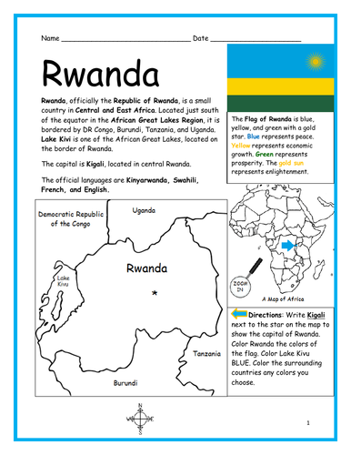
Introduce your students to the country of RWANDA with this printable handout of two worksheets (plus answer key). Your students will read a brief introduction to Rwanda (location, capital, flag, language), write ‘Kigali’ next to the star on the map to show the capital, color the small map, and use the map and compass to answer 7 questions on page 2. Colored pencils and a pen or pencil are needed for this activity. No other prep needed. Basic Geography worksheet includes a simple map to introduce the country of Rwanda and practice cardinal/ordinal directions.
For use with Interactive Notebooks: After the worksheets are completed, students can cut out the map and flag and paste into the notebook under the topic of Africa/Sub-topic: Rwanda. Under the map and flag, your students can write a summary in their own words of what they now know about this country. Collect worksheets for other countries of Africa to add to the notebook! Please browse this store for a selection of printable Geography worksheets for other countries of Africa (and beyond!).
Thank you so much for using my Geography worksheets in your classroom!