Hero image

Willson Education's Shop

Average Rating4.11
(based on 753 reviews)

I'm a Geography teacher with experience educating at various levels, ranging from mainstream schools, SEN and extra-curricular tuition. I also have experience in teaching humanities, English and PSHE topics. My resources are designed primarily as schemes of works for mainly Geographical topics with all levels considered

555Uploads

725k+Views

403k+Downloads

I'm a Geography teacher with experience educating at various levels, ranging from mainstream schools, SEN and extra-curricular tuition. I also have experience in teaching humanities, English and PSHE topics. My resources are designed primarily as schemes of works for mainly Geographical topics with all levels considered
The Quechua Tribe
WillsonEducationWillsonEducation

The Quechua Tribe

(0)
High in the Andes Mountains of South America live the Quechua tribe. They live by farming potatoes, barley and maize, as well as other crops. They keep cattle, sheep, chickens and…llamas. Llamas are close cousins of camels, minus the hump, and come in very handy for riding and carrying heavy loads. These worksheets have the students explore how llamas and the Quechua Tribes have adapted to their environment and how, with our changing climate, the llamas and Quechue could continue to adapt.
The Matmata People
WillsonEducationWillsonEducation

The Matmata People

(0)
Matmata is a small Berber speaking town in southern Tunisia with a population of about 2,226 who live in traditional underground structures. This type architecture is based on localized needs and construction materials, and reflecting local traditions. It evolves over time to reflect the environmental, cultural, technological and historical content in which it exists. These methods can often be dismissed as crude and unrefined. These worksheets have the students explore the Matmata People’s homes and debate whether having a Star Wars picture filmed at the location would have a positive ro negative affect on their lives.
The Matses Tribe
WillsonEducationWillsonEducation

The Matses Tribe

(1)
Around 2,200 Matsés live on the Peru-Brazil frontier in the Amazon rainforest. The international boarder that splits their home is the Yaquerana River and it runs through the heart of their land. To the Matsés the streams, floodplains and white-sand forests make up an ancestral territory that is shared by the entire tribe. These worksheets have the students look closely at the acate green tree frog which, as well as being a culinary delicacy, are used to increase hunting ability. Additionally the students investigate an oil company who are exploring the Matses’s land to drill.
The Awa Tribe
WillsonEducationWillsonEducation

The Awa Tribe

(0)
The most endangered tribe in the world live deep in the Amazon rainforest, they are an ancient group of around 400 who carry everything they own; their children, their weapons and their pets. These people are so close to being wiped out forever that they are kept safe, away from the modern world. As a result, very few people have ever met the Awá. These worksheets have the students gather information from a video and use it to explain the plight and rescue of the Awa Tribe.
The Chagga People
WillsonEducationWillsonEducation

The Chagga People

(0)
The Chagga people have lived on the slopes of Mount Kilimanjaro for hundreds of years, they believe the mountain is holy and treat it with respect. However, since the area was given National Park status in 1970 there has been a sharp increase in hikers. These worksheets have the students imagining they run a local primary school, however the families struggle to afford the uniforms, shoes, books and lunches which result in many children not attending. Their task is to decide how best to use aid money to help try double attendance to the school.
India's Wealth
WillsonEducationWillsonEducation

India's Wealth

(0)
These worksheets have the students reasoning what we need to live and looking specifically at how wealth is distributed in India
Indian Food
WillsonEducationWillsonEducation

Indian Food

(0)
This lesson allows students to identify different fruits and vegetables which originate from India. They sample the foods and give a detailed description of specific fruits. They also have the opportunity to compare differences between ours and traditional Indian meal times
India's Climate
WillsonEducationWillsonEducation

India's Climate

(0)
As India is such a large country it’s not surprising to find that the climate varies from place to place and that these variations have different impacts of people’s lives. These worksheets help students to understand climate graphs, how to read and draw them. They also give them a chance to develop their own graph and peer mark eachothers ideas with supporting comments.
India's Culture
WillsonEducationWillsonEducation

India's Culture

(0)
The culture of a group of people is their way of life. It includes their customs, hobbies, foods, fashions, beliefs and traditions; these are dependent of the country they live in, family background, sex and age. Many parts of the world are multicultural which means many different groups of people live alongside one another as a result of moving to new areas to live ad bringing their cultures with them. This is a chance for your students to get out of your seats and, sensibly, move around the classroom gathering evidence with their classmates to learn about India’s culture.
What Is The Route Of The Tsars - The Trans-Siberian Railway
WillsonEducationWillsonEducation

What Is The Route Of The Tsars - The Trans-Siberian Railway

(0)
In the late 19th century, Japan, Britain and America gained footholds on the Chinese coast as bases for their trade with China and the Orient. Russia needed to secure a foothold in the east as well as securing the vast expanses of Siberia, so in 1891 Tsar Alexander III approved a plan for a trans-continental line linking Moscow and St Petersburg with Vladivostok on the Pacific coast, as this was the only year-round ice-free port in Russia. These worksheets allow the students to study the Trans-Siberian railway, study its timeline and produce a suitable logo an slogan which could be used to advertise the journey.
Russia's Climate
WillsonEducationWillsonEducation

Russia's Climate

(0)
Due to Russia’s vast size and compact shape its climate spans many environments, European Russia and Asian Russia have continental climates; apart from the extreme southeast and the northern tundra. These worksheets look at four locations within Russia and learn how to draw climate graphs and how to read them
Where In Russia?
WillsonEducationWillsonEducation

Where In Russia?

(0)
This worksheets helps students to produce a map with the main cities and physical features of Russia, including rivers and mountain ranges
Who Makes Up Russia?
WillsonEducationWillsonEducation

Who Makes Up Russia?

(0)
These worksheets look at the Russian language and the others which are spoken within the country as well as the religions and ethnic groups which make up the people
The Winter Palace, Russia
WillsonEducationWillsonEducation

The Winter Palace, Russia

(0)
These worksheets help students learn about the history of the Winter Palace in Russia through a wordfill exercise and develop the skill of field sketching
The United Nations
WillsonEducationWillsonEducation

The United Nations

(0)
After the atrocities of the Second World War (millions of Jews were killed and many others) some countries got together and decided that something like that could not happen again. They formed the United Nations. The United Nations drew up a list of basic Human Rights (1948) that everyone should be entitled to – this is called the Universal Declaration of Human Rights. These worksheets help the students to discuss what they consider essential to living and compare their thoughts to Maslow’s hierarchy of needs. In addition they look in detail at the Universal Declaration of Human Rights and discuss whose responsibility it is to uphold these
Geography Of Sport - FIFA World Cup Russia
WillsonEducationWillsonEducation

Geography Of Sport - FIFA World Cup Russia

(0)
This 32 page booklet gives students the opportunity to explore the FIFA World Cup, Russia and their connections to geography using different Geographical themes and skills. Chapters include: Why Is Football So Popular? How Is Football Linked To Geography? Who Are FIFA? Who’s Taking Part In 2018? Friendly Rivals We Are Number One! Football As An Economic Activity Flag Crossword Getting The Vote What Do You Know About Russia? Where In Russia? Population And Nationality Country Climate Seeing The Sites What Have We Borrowed? Build A Brand Knowing The Neighbours Football Acrostic How Is This Omar Linked To Football?
Victoria Falls, Africa - Field Sketches
WillsonEducationWillsonEducation

Victoria Falls, Africa - Field Sketches

(0)
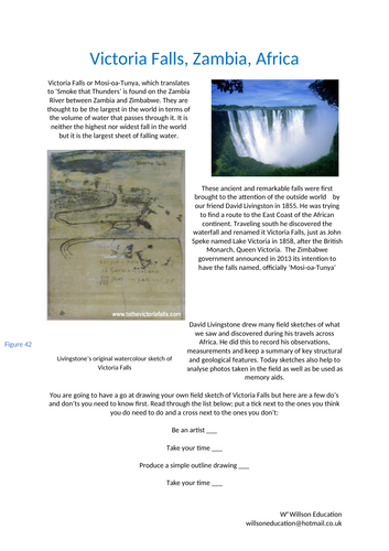
Victoria Falls or Mosi-oa-Tunya, which translates to ‘Smoke that Thunders’ is found on the Zambia River between Zambia and Zimbabwe. They are thought to be the largest in the world in terms of the volume of water that passes through it. It is neither the highest nor widest fall in the world but it is the largest sheet of falling water. This worksheet helps your students to understand the dos and don’ts of field sketching. Victoria Falls is used as an example to help practice this important skill
The Lighthouse Of Alexandria
WillsonEducationWillsonEducation

The Lighthouse Of Alexandria

(0)
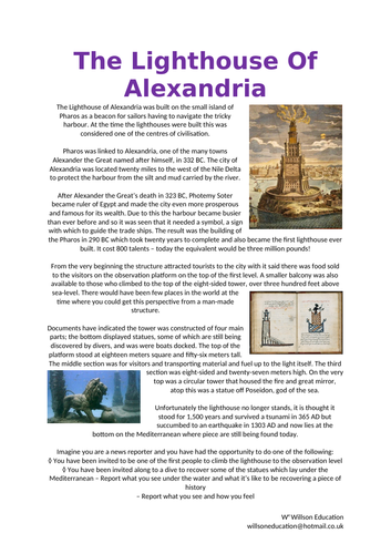
The Lighthouse of Alexandria was built on the small island of Pharos as a beacon for sailors having to navigate the tricky harbour. At the time the lighthouses were built this was considered one of the centers of civilisation. Unfortunately the lighthouse no longer stands, it is thought it stood for 1,500 years and survived a tsunami in 365 AD but succumbed to an earthquake in 1303 AD and now lies at the bottom on the Mediterranean where piece are still being found today. Imagine you are a news reporter and you have had the opportunity to do one of the following: ◊ You have been invited to be one of the first people to climb the lighthouse to the observation level ◊ You have been invited along to a dive to recover some of the statues which lay under the Mediterranean – Report what you see under the water and what it’s like to be recovering a piece of history – Report what you see and how you feel
Machu Picchu
WillsonEducationWillsonEducation

Machu Picchu

(0)
These worksheets help your students to learn about the history of how Machu Picchu was discovered by the Western World and how it is used today as a tourism destination. The Inca Trail is also discussed. Please email me at willswoneducation@hotmail.co.uk for the two videos to go with this lesson
Chichén Itzá
WillsonEducationWillsonEducation

Chichén Itzá

(0)
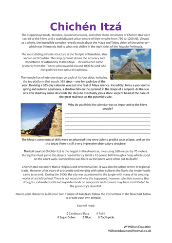
The stepped pyramids, temples, columned arcades, and other stone structures of Chichén Itzá were sacred to the Maya and a sophisticated urban centre of their empire from 750 to 1200 AD. Viewed as a whole, the incredible complex reveals much about the Maya and Toltec vision of the universe—which was intimately tied to what was visible in the night skies of the Yucatán Peninsula. The most distinguishable structure is the Temple of Kukulkan, also known as El Castillo. This step pyramid shows the accuracy and importance of astronomy to the Maya – This influence came primarily from the Toltecs who invaded around 1000 AD and who merged their two cultural traditions. This lesson gives your students the chance to build their own Temple Of Kukulkan and test the shadow produced to see how successful the Maya People were at producing an accurate calendar.