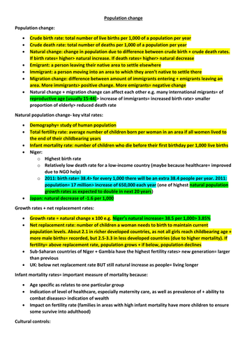
Population change
Models of natural population change- the demographic transition model
Britain’s demographic transition
Demographic transition model applied to countries with contrasting physical + human settings
Population structure
Migration
European migrant crisis 2015
Colour coded: green statistics; yellow definitions; blue dates
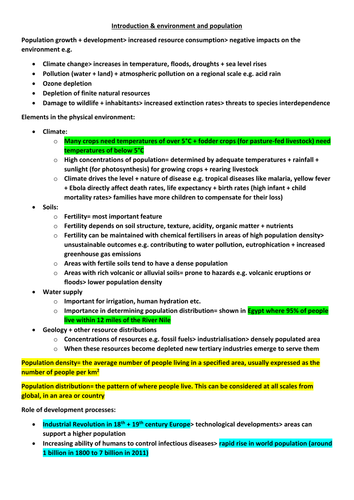
Elements in the physical environment
Role of development processes
Food production and consumption
Polar and tropical monsoon climates
Climate change and agriculture
Soils
Food security
Colour coded: green statistics; yellow definitions; blue dates
Powerpoint and worksheet where pupils find out how various problems on Planet Earth link together and have climate change as a common thread
Starter: label a temperature graph of the past 1000 years with major events that added pollution to the atmosphere
Students then answer a series of differentiated questions after reading and discussing different aspects of our changing climate:
sea level rise + migration + starvation + drought + extreme weather + disease + extinction
Powerpoint and worksheets covering constructive plate boundaries, collision zones and volcanic hot spots.
Starter is an odd-one-out game involving keywords and place names linked to tectonics.
Constructive margins focuses on the Galapagos Islands (Nazca and Cocos Plates) where pupils draw a cross section of the boundary then use clues to annotate key features.
Hot spots and magma plumes are then introduced, linking to the African Rift Valley as a land-based plate boundary above a magma plume. A half-time Plenary looks at the importance of the Rift Valley to human evolution.
Then pupils find the answers to questions about the San Andreas Fault through a comprehension exercise and report back to the class.
The final piece of work is an A3 worksheet which combines constructive, destructive and collision boundaries. Pairs of pupils try to remember as much as they can by summarising their recent learning.
The Plenary returns to the Galapagos and the islands' importance in Darwin's Theory of Evolution.
Includes video links and differentiated questions.
Enough for two lessons...
Powerpoint and worksheet where pupils work together to find links between climate change, human health, animal habitats and water supplies
Starter looks at pupils' opinions of greatest threats to humanity, then statements from major organisations as a comparison
Students then swap info (from fact sheets) so that each can complete their own set of links
Differentiated questions:
1-3: How will climate change affect the World?
4-6: What are the social and economic effects of climate change?
7-9: What are the possible political effects of future climate change?
Plenary: discussion of pupils' concerns for the future, then a video of Leonardo DiCaprio's speech at the United Nations
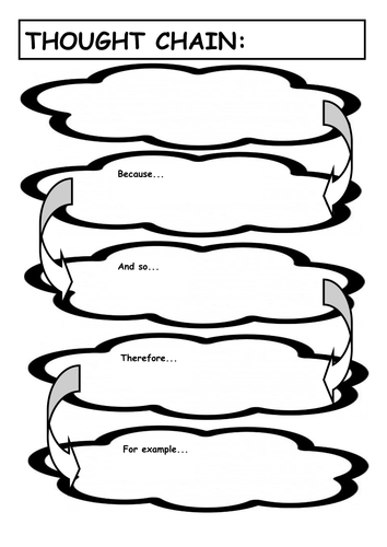
I use this layout to train pupils from KS3 how to put added detail into their answers
The first cloud is for the initial idea that starts of their answer
The following clouds (because, and so, Therefore) make them explain and then expand on their answer
The final cloud (For example) makes them give place specific info (eg data, placename, quote) needed for higher level answers
After using the 'clouds' a few times, the pupils become used to the layout/technique and can write their answers as more detailed paragraphs
Powerpoint and worksheets explaining the Milankovitch Cycles, obliquity, precession and eccentricity. Starter covers the Greenhouse effect. Then goes onto volcanic and sunspot activity. Differentiated questions about sunspots:
1-3: How does the Sun’s energy affect the Earth’s climate?
4-6: How do sunspots affect climate change on Earth?
7-9: What is the correlation between sunspot activity and climate change?
Also, differentiated questions about the Greenhouse Effect.
Links to videos showing computer simulations of glaciation and the Greenhouse Effect.
Enough for two lessons
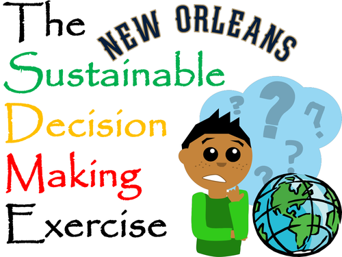
A decision making exercise (set up as a lesson) looking at future options for protecting New Orleans from hurricanes/flooding
New Orleans lies below sea level with a levee system that was designed for hurricanes of no greater intensity than Category 3. The city’s natural defence of the surrounding marshland has been drained, built on or eroded away. A computer model predicted that up to 250,000 people could die in the next Category 5 storm.
The US Government has four options for the 21st Century…
Option 1:
Regenerate the wetlands of the Mississippi Delta
Option 2:
Maintain and heighten the existing levées
Option 3:
Do nothing, let nature take her course
Option 4:
Evacuate the people of New Orleans in hazardous times
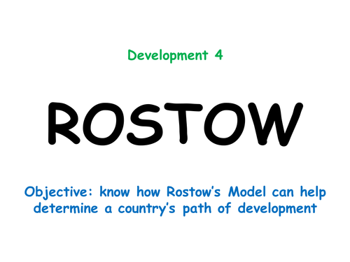
Powerpoint and worksheets covering Rostow's Model and the UN's Millennium Development Goals. Starter involves fitting countries onto an A3 version of the model by comparing socio-economic data. Nigeria is used as a Case Study for the MDGs. Pupils assess the success of Nigeria in working towards those Goals and suggest further improvements. Written conclusion: F: Describe how Nigeria is improving her level of development
H: Explain how well Nigeria is meeting her Millennium Development Goals
G&T: Is Nigeria ready to move up on the Rostow Model? Explain your answer
Powerpoint looking at the Upper Stage of the River Tay
Starter: Pupils use maps to discuss the links between the location of Britain’s rivers, patterns of landscape and patterns of precipitation
Main activities: video link introducing the Upper Stage of the Tay
Carousel of activities about erosion types (memorisation), forestry (exam-style questions), features of upland valleys (SPAG), hill sheep (exam-style question), waterfalls (use mystery clues to annotate sequence of diagrams) and HEP (exam-style questions)
Second lesson used for class discussions to recap learning using slides and videos
Class debate on the sustainability of forestry, sheep farming and HEP in the Tay Valley
Differentiated questions about the features found in the Upper Stage
Plenary: simple living graph of the deforestation of Britain over the past 1,000 years
Enough for two lessons
Powerpoint looking at the skill of constructing cross-sections from contour lines
Starter: recap of the formation of v-shaped valleys (including video link)
Main activities: step-by-step slides taking pupils through how to construct a labelled cross-section of the Upper Stage of the River Tay
Analysis of a photo of the Middle Stage of the River Tay to compare human and physical features and then to compare those with a photo of the Upper Stage
Pupils then construct their own cross-section of the Middle Stage
Differentiated questions comparing the cross-sections of the three river stages (the Upper Stage is already completed for them)
Plenary: pupils have to look for clues in photos of a completely different river (the Wisla in Poland) to decide in which stages they were taken
Powerpoint looking at the effect of weathering on the UK's landscapes
Starter: Pupils discuss what might have damaged various materials shown in photos
Main activities: video links, discussion and annotation of diagrams to show sequence of freeze-thaw (frost shatter) and exfoliation (onion skin) weathering
Slides about chemical and biological weathering (for note taking)
Differentiated questions to explain how weathering has affected the chalk landscape of The Seven Sisters (East Sussex, Southern England)
Plenary: video links recapping the four types of weathering covered in the lesson
Powerpoint looking at the formation of meanders and oxbow lakes in the Middle Stage of the River Tay
Starter: sketch and match definitions of four types of transportation
Main activities: step-by-step slides taking pupils through the formation of meanders and oxbow lakes. Each pupil is given a fact about the processes involved. Sketches are made of meanders in different stages then pupils use their clues to teach the rest of the class about what is happening so they can label their diagrams. Also includes some photo analysis of river valleys in the real world
Second part gets pupils to draw and label a cross-section of an asymmetrical meander using width, depth and velocity data
Differentiated question: 1-3: Describe how a river channel changes from one side of a meander to the other; 4-6: Explain how a meander can become an oxbow lake over time; 7-9: Explain how meanders and oxbow lakes can be both useful and cause problems for humans
Plenary: pupils recap learning by describing and explaining features seen in a series of satellite photos showing a meander turning into an oxbow over time
Powerpoint and worksheets introducing the concept of distinctive landscapes
Two main activities: assessment of five landscape photos using description (looking for evidence of physical, human and transitory features) followed by bilpolar evaluations of two further landscapes
Differentiated question:
1-3: Describe the main features of the landscape where you live
4-6: Explain the differences between urban and rural landscapes in the UK
7-9: Explain how human and physical features interact to form a named UK landscape
Plenary gets pupils to discuss the most beautiful landscapes they have seen locally, nationally and internationally
Includes video link ('Beautiful Britain')
Case Study: The 2015 Nepal Earthquake
One Powerpoint but with enough detail for two or three lessons
Starter looks at possible advantages and disadvantages of Nepal's geography when it comes to dealing with earthquakes
Main body of the work is divided into:
LOCATION: map skills exercise
CAUSES: plate tectonics, India/Eurasia collision zone; graphing of historic data to look for tectonic patterns; shallow depth earthquakes below the Himalayas
EFFECTS: mapping proportional circles to show aftershocks; choropleth mapping exercise to show deaths by district; discussion of social, economic and environmental effects which are then analysed using an A3 worksheet to link and pairs of effects
SOLUTIONS: analysis of the usefulness of accepting foreign aid; grid worksheet to assess the sustainability of alternative earthquake proofing (car tyres, plastic bottles, straw and bamboo!)
PLENARY: how was Mount Everest affected by the 2015 earthquake?
Includes several resources, differentiated questions and links to internet media
Powerpoint and worksheet covering the Global Circulation System and the effects of latitude on climate. Starter looks at photos and how extreme weather might affect human life in those places. Lesson then goes through why the equator is hot/wet, the formation of deserts at 30 degrees and the reasons for cold deserts at the Poles. The worksheet is filled in through the lesson to explain the links between latitude, atmospheric cells and biomes. Differentiated GCSE style questions at the end of each section.