I'm a teacher and the Author of the Amazon e-book;' Time Smart Teaching' and my mission is to create Geography resources to help teachers save time and reduce their workload. I am sharing additional time saving tips for teachers on my YOUTUBE channel ' Time Smart Teaching' if you fancy dropping by!
I'm a teacher and the Author of the Amazon e-book;' Time Smart Teaching' and my mission is to create Geography resources to help teachers save time and reduce their workload. I am sharing additional time saving tips for teachers on my YOUTUBE channel ' Time Smart Teaching' if you fancy dropping by!
This is a table designed to compare all major aspects of your chosen human/ physical fieldwork for GCSE Geography. Written specifically for AQA specification and filled in with examples from Urban regeneration and a coastal long-shore drift investigation, it can easily be adapted to suit your needs. Great revision tool for the paper 3 examination.
In this 5th lesson in our cold climate series ’ Pol to Pole’ and following on from lesson 4 on extreme tourism in the Antarctic Cruise, learners examine human impacts on cold climates and Antarctica. Students main task is to evaluate which human threats are the most pressing and urgent, but completing a diamond 9 activity. Students could then follow this up by writing an international code of conduct for Antarctic scientists and visitors.
This building-off-grid project is ideal for delivery in the classroom for years 8 through to 11 or set as an independent task for distance-learning or home-based study. Also suitable for celebrating ’ Earth Day’ in April with a focus on reducing carbon footprint. Since being stuck on lock-down I have been binge-watching episodes of USA based TV-series like ’ last of the Alaskans’ and ’ Building off Grid’ which follow families as they design and self-build their own cabins and earth-ship style homes in remote areas of Arizona and Alaska. The aim is to live sustainably and in harmony with the landscape and ecosystem around them.
This lesson / project will help GCSE/ KS4 students make connections in their learning with the Geography ’ Living World’ topic, especially around explaining how humans have adapted to the opportunities and challenges of living in extreme conditions such as the Tundra Biome and the Hot Desert regions. Students could easily talk about home design and crop growing/ subsistence farming in their examinations following the AQA spec A curriculum.
The students must choose where they want to live their off grid lifestyle; either Arizona or Alaska, and the Power Point goes through the benefits and drawbacks of doing so in each ecosystem. There are video links to relevant video content showing some aspects of cabin-building in both of these environments.
Then students enlist 3 helpers to help build their cabin, and roll a dice to determine their allocated budget they can use to buy materials for the cabin project. Using this budget, they can chose from a ‘menu’ worksheet of construction options to custom-build their cabin. They have a choice of sketching out their design with a floor plan, or actually building a model of their cabin from lego/ cardboard/ paydough etc. If submitted as a distance learning activity it would be great to make it into a competition, and invite students to submit pictures of their designs electronically for display. There are some ideas for follow-on activities on the slides.
Written for year 7, this lesson has a literacy focus and introduces students to some of the physical geography and landscape characteristics of the Tundra Biome and it’s cold environment. Students analyse the descriptive vocabulary and adjectives used to describe Svalbard, then build a bank of keywords as a class to use independently in their travel writing. The aim of the lesson is to complete an extended piece of writing to take the reader on an imaginary journey through the tundra around the archipelago of Svalbard ( travel journalism skills). There is a writing frame worksheet to support students write about the physical and human geography using the 5 senses. This differentiated lesson could easily be adapted for year 8 or 9 and gets student familiar with cold environments at GCSE geography.
This GCSE Geography lessons looks in-depth at the land use patterns around the edge of Manchester’s city, or the urban-rural fringe. This area is where the city meets the countryside and is desirable for a range of development opportunities including golf courses, airports and out of town shopping centres.
This lesson looks at an OS map of Manchester for the starter task, although using BING maps online will substitute if you do not have hard copies. The lesson develops map skills and annotation skills. There is a brownfield site card sort activity also to help students understand the advantages and disadvantages of building on brown field sites.
This lesson was written to compliment the AQA spec A GCSE curriculum, and briefly touches on the Burgess model, and how Manchester fits into this framework. It is part of other Manchester-based case study resources, also available from my shop. To go with the Urban Issues and Challenges topic SOW.
Threats to the tropical rainforest stem from population pressure and climate change. This fragile biome is used for subsidence farming mineral extraction and hydro-electric power. This code breaking resource can be used to introduce threats for the first time, or as a revision activity. This worksheet is designed for Edexcel B specification, however it is suitable for AQA also/ The completion requires access to the textbook 'Edexcel geography B - pages 270-271 in the Pearson Textbook by John Hopkin et al ISBN: 9781446927762. ( page copy available with this resource) The resource is a reading comprehension exercise where they find relevant information from the 2 page of text and images.
This full lesson gets students thinking about describing and explaining where most of the world’s ice is found. The Tundra biome is found at far north and south latitudes where the days are short and the winters are long. Permafrost and taiga forests are located here and only well adapted plants and animals survive, hence the name ’ treeless mountain tract’. The lesson has a differentiated map task where student must shade and label places within the tundra biome. There is also a match-up activity where they must link up definitions of icy landscape features with their pictures: glaciers, ice sheet, ice caps and snow patches.
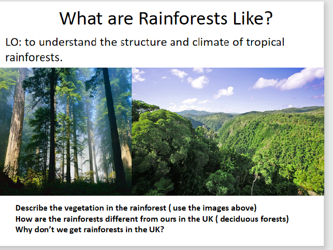
This full lesson combines sketching skills and reading comprehension to annotate a diagram of the different rainforest layers: forest floor, understory, canopy and emergent layer. Tropical rainforest biomes are found around 0 degrees lattitude, also known as the equator. Almost all GCSE geography examination boards expect students to have a detailed understanding on the layers and features of the rainforest. This lesson includes a kinathstectic mini-quiz to test students understading on each of the layers; they move around the 4 corners of the room to classify statements on each of the different layer characteristics.
Most countries devise their electricity generation mean through a mix of fossil fuels and renewable energy resources. This A3 revision poster gets students analysing energy mix trends from pie charts located onto the world map. The original map is available as a free download from the EDF energy website; edfenergy.com/energy/education however a large copy is made available on the second slide of the powerpoint. Students answer prompt questions onto the A3 sheet around a copy of the pie-chart map, such as ’ describe the UK’s energy mix’ and also ’ compare the energy mix between the USA and Brazil.’ There are questions designed to make student connect more broadly to the topic ’ Challenge of Resource Management. The energy mix section on this topic is core contact, therefore important for all students to understand. These would make ideal classroom displays or as independent revision work in the lead up to examinations. This worksheet is designed for middle to higher ability students but could be easily adapted for lower abilities with a few prompts/ sentence starters here and there.
This lesson introduces the concept of ‘sustainable toursim’ and then students are given a task of designing an eco-lodge according to the principles of sustainability. there is a peer assessment grid to judge the sustainability of pupil designs. This lesson was made for the Unit 1 examinatioin for Btec Travel and Tourism, but equally as good for Ks3 Geography.
The geology of a coastline will have an impact on how quickly it retreats backwards due to the erosion processes off hydraulic action and abrasion. This lesson considers how the aspect, rock type, layers and existing sea defenses all contribute to different rates of erosion. The meanings of the terms lithology, concordant and discordant coastlines are apparent throughout the lesson. This lesson was designed initially for an interview, and worked really well for a 50 minute lesson duration.
starter: Students examine the picture and discuss what is happening to the houses and why. They then compare two coastlines; Durdle Door and Swanage Bay, and predict which one they think will retreat the quickest, with the aid of maps.
Main - students annotate their images/ maps with information about the geology of each coastline, from either the teacher talk or print-outs from the slides. they can be encouraged to do their own research also at this point. Then they attempt a 4 mark exam question designed to test their understanding of the geology and how it influences coastal erosion.
plenary- a gap fill exercise on an image to test students recall on the main factors discussed in the lesson.
A code-busting themed revision worksheet aimed at developing key terms associated with fieldwork activities and the paper 3 AQA examination for GCSE geography. This easily lends itself to any school or centre and develops both literacy and numerical skills needed for the paper 3 exam. Full answers are provided.
Combining creativity and map skills where students need to read the map to fill out gaps in a story. The story will test students understanding on map symbols, grid references,direction, scale and distance, and there are extension questions which require critical thinking around the map for the most able students. Answers included! You could even ask your students to write their own map skills story too based on a map of their choice to embrace national story telling week.
This is a stand-alone activity using De Bono’s thinking skills/ hats to analysis a GIS image of air pollution levels accorss the uk.
There is a link to the met office website to help complete the task, and an extension activity for the more able. The questions are colour-coded into the 6 hats, however you don’t need any prior knowlege on these to utilize the resource. Originally written for our year 9 GIS scheme of work.
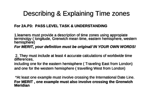
This Powerpoint lesson describes what time zones are, and explains how travellers are effected as they travel East or West ( Jetlag, DVT. There are activities where students have to calculate time zone differences and questions to check their understanding in conjunction with the official Btec Travel and Tourism Textbook. This lesson is ideal to accompany the coursework element at Pass and Merit level.
A differentiated main activity to allow students to find important places within the city of Manchester using an OS map. Could easily be adapted to other cities. Good for a range of abilities and incorporates 4 and figure grid references and extention task for independant work of more able using online Bing maps GIS free website.
This is a great visual revision resource for GCSE AQA Spec, covering the basics on causes, effects and sustainable management strategies for the Amazon Rainforest case study. I initially gave students blank copies of a tree and asked them to fill in their own knowlege, then gave my filled out version to lower ability students. They then used this infomation to help answer a range of past paper questions on the case study. There are 2 exam questions below the work sheet to test their understanding.
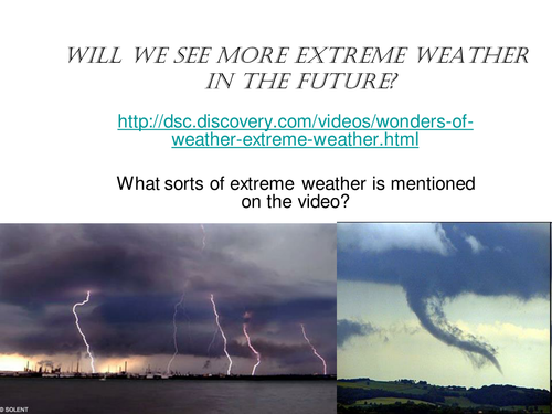
This is a lesson looking at trends in extreme tornadoes and where they occur. Activities include a mapping activity, analyzing data and a group facts race exercise, followed by a journalistic report.
Differentiated resource to allow students to show what they know about the causes effects and solutions to climate change (global warming).\n\nThere is a level assesment criteria and a writing frame to help less able students.\n\nSuitable for years 7 and 8
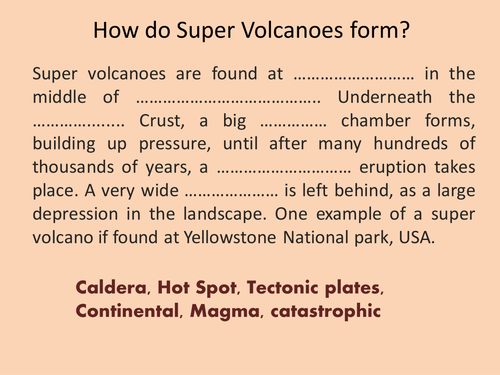
Mercalli scale, Richter scale, Super volcano
Full lesson with a starter recapping on how super volcanoes form (close passage/ gap fill) then moves on to look at how earthquakes are measured. A practical task on classifying earthqake damage by analysing video footage from youtube is included.