Thank you for visiting! Here you will find a selection of printable, interactive worksheets for your classroom: Basic Geography worksheets with simple maps, ESL, Spanish, Bible, Reading Comprehension and more. I hope you find the resources useful! Reviews are welcome and very much appreciated. Thank you so much.
Thank you for visiting! Here you will find a selection of printable, interactive worksheets for your classroom: Basic Geography worksheets with simple maps, ESL, Spanish, Bible, Reading Comprehension and more. I hope you find the resources useful! Reviews are welcome and very much appreciated. Thank you so much.
Find the 21 Spanish-Speaking Countries in the Word Search Puzzle! One printable Word Search Puzzle (plus answer key).
Countries to find in the Word Search Puzzle: Argentina, Bolivia, Chile, Colombia, Costa Rica, Cuba, Dominican Republic, Ecuador, El Salvador, Equatorial Guinea, Guatemala, Honduras, Mexico, Nicaragua, Panama, Paraguay, Peru, Puerto Rico, Spain Uruguay, Venezuela.
Flags for each country included!
Please browse this store for other worksheets to introduce your learners to the Spanish-Speaking Countries! SPANISH-SPEAKING COUNTRIES FILL IN THE BLANKS, SPANISH-SPEAKING COUNTRIES SCRAMBLE, and more! Worksheets also available to introduce your learners to each Spanish-Speaking country!
Thank you so much for using my worksheets in your classroom! I hope you find them useful and fun. Reviews are welcome and very much appreciated. Please FOLLOW THIS STORE!!
Introduce your students to GREECE with this printable handout of two worksheets (plus answer key). Your students will read a brief introduction to Greece (location, capital, flag), write ‘Athens’ next to the star on the map to show the location of the capital, color the map and flag, and use the map and compass to answer 7 questions on page 2. Colored pencils and a pen or pencil are needed for this activity. No other prep needed. Basic Geography worksheet with a simple map to introduce Greece and practice cardinal and ordinal directions.
For use with Interactive Notebooks: After the worksheets for Greece are completed, students can cut out the map and flag and paste into the notebook under the topic of Europe/Sub-Topic: Greece. Under the map, students can write a summary in their own words of what they now know about this country. Collect worksheets for other countries of Europe to add to the notebook! Please browse this store for a selection of worksheets for other countries of Europe (and beyond!).
Thank you so much for using my Geography worksheets in your classroom! I hope you find them useful! Reviews are welcome and very much appreciated.
Albania, Turkey Crete, Macedonia, Bulgaria, Aegean Sea, Mediterranean Sea, Ionian Sea.
Introduce your learners to the countries of the Middle East with this printable activity!
Using the map of the Middle East, find the 17 countries in this Word Search Puzzle. They can be found forward or backward. Included: Bahrain, Cyprus, Egypt, Iran, Iraq, Israel, Jordan, Kuwait, Lebanon, Oman, Palestine, Qatar, Saudi Arabia, Syria, Turkey, UAE (United Arab Emirates), Yemen. One printable worksheet (plus answer key). Instant download. Print and go!
Thank you so much for using my Geography worksheets in your classroom!
Please browse this store for a selection of printable worksheets for each country of the Middle East (and beyond!).
Introduce your students to the country of Slovenia in Europe with two worksheets (plus answer key). Your students will read a brief introduction to Slovenia (location, capital, flag, language), write Ljubljana next to the star on the map to show the location of the capital, color the small map, and use the map and compass to answer 9 questions on page 2. Colored pencils and a pen or pencil are needed for this activity. No other prep needed. Basic Geography worksheet with a simple map to introduce Slovenia and practice cardinal and ordinal directions.
For use with Interactive Notebooks: After completing the worksheets, students can cut out the map and flag and paste into the notebook under the topic of Europe/Sub-Topic: Slovenia. Under the map and flag, students can write a summary in their own words of what they now know about this country. Collect worksheets for other countries of Europe to add to the notebook! Please browse this store for a list of worksheets for other countries of Europe (and beyond!).
Thank you so much for using my Geography worksheets in your classroom! I hope you find them useful. Reviews are welcome and very much appreciated!
Printable Handout (1 page plus answer key) ‘A Summer Day at the Beach.’ Students will fill in the blanks using the word bank of past-tense verbs: parked, swam, collected, drove, decided, watched, walked, sat, read, ate, packed, carried.
Cloze activity for ESL, EFL, ELL, ESOL. Vocabulary building, Reading Comprehension, Grammar.
Introduce your learners to Kenya with two worksheets (plus answer key). Your students will read a brief introduction to Kenya (location, capital, flag, language), write ‘Nairobi’ next to the star on the map to show the location of the capital, trace the line of the equator across Kenya, color the small map and flag, and use the map and compass to answer 9 questions on page 2. Colored pencils and a pen or pencil are needed for this activity. No other prep needed. Basic Geography worksheet with a simple map to introduce Kenya and practice cardinal and ordinal directions.
For use with Interactive Notebooks: After the worksheets are completed, students can cut out the map and flag and paste into the notebook under the topic of Africa / Sub-Topic: Kenya. Under the map and flag, students can write a summary in their own words of what they now know about this country. Collect worksheets for other countries of Africa to add to the notebook! Please browse this store for a selection of worksheets for other countries of Africa (and beyond!).
Thank you so much for using my Geography worksheets in your classroom! Reviews are welcome and very much appreciated.
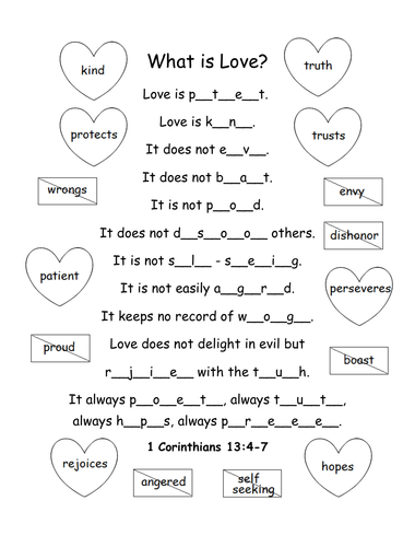
Printable activity/coloring page for 1 Corinthians 13:4-7. What is love? Fill in the blank letters for each word to complete the bible verse.
Love is patient, love is kind. It does not envy, it does not boast, it is not proud. It does not dishonor others, it is not self-seeking, it is not easily angered, it keeps no record of wrongs. Love does not delight in evil but rejoices with the truth. It always protects, always trusts, always hopes, always perseveres.
1 Corinthians 13:4-7 (NIV)
Thank you so much! God bless!
This printable handout of 5 pages includes a mini-bio of Bert Lahr, the actor who played the cowardly lion on The Wizard of Oz. ‘The Man Behind the Whiskers’ includes 4 photos, 7 vocabulary words, and 7 ‘True or False’ questions for reading comprehension.
Vocabulary words include: cowardly, leapt, ferociously, sobbing, journey, ad-libbed, biography
Thank you so much for using my worksheets! I hope you find them useful. Reviews are welcome and very much appreciated! Please browse this store for more worksheets to use in your classroom!
Introduce your students to the SOUTHEAST REGION of the United States with this printable handout of one page (plus answer key). Using the map of the Southeast Region, find the twelve states in the word search puzzle: Virginia, North Carolina, South Carolina, Georgia, Florida, Alabama, Arkansas, Kentucky, Louisiana, Mississippi, Tennessee, West Virginia.
Handouts also available for other regions! Please check out this store for:
-SOUTHWEST REGION MAP AND WORD SEARCH
-NORTHEAST REGION MAP AND WORD SEARCH
-MIDWEST REGION MAP AND WORD SEARCH
-WEST REGION MAP AND WORD SEARCH
Thank you so much for using my Geography worksheets in your classroom!
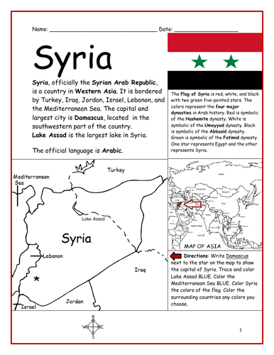
Introduce your students to SYRIA with this printable handout of 2 worksheets (plus answer key). Your students will read a brief introduction to Syria (location, capital, flag, language), write 'Damascus’ next to the star on the map to show the capital, color the small map, and use the map and compass to answer 9 questions on page 2. Colored pencils and a pen or pencil are needed for this activity. No other prep needed. Basic Geography worksheet with a simple map to introduce Syria and practice cardinal and ordinal directions.
For use with Interactive Notebooks: After the worksheets are completed, students can cut out the map and flag of Syria and paste into the notebook under the topic of Asia/Sub-Topic: Syria. Under the map and flag, your students can write a summary in their own words of what they now know about this country. Collect handouts for other countries of Asia to add to the notebook! All available in this store! Please browse this store for a selection of printable handouts for other countries of Asia (and beyond!).
Thank you so much for using my Geography worksheets in your classroom! I hope you find them useful. Reviews are welcome and very much appreciated!
Using the map of Ireland, find the four provinces and thirty-two counties of Ireland in the Word Search Puzzle! They can be found forward or backward.
Provinces and Counties included:
Connacht: Galway, Leitrim, Mayo, Roscommon, Sligo
Ulster: Antrim, Armagh, Cavan, Donegal, Down, Fermanagh, Londonderry, Monaghan, Tyrone
Munster: Cork, Kerry, Limerick, Tipperary, Waterford, Clare
Leinster: Carlow, Dublin, Kildare, Kilkenny, Laois, Longford, Louth, Meath, Offaly, Westmeath, Wexford, Wicklow
One printable word search puzzle (plus answer key).
You may also be interested in:
IRELAND - INTRODUCTORY GEOGRAPHY WORKSHEET
IRELAND - PROVINCES AND COUNTIES INTRODUCTORY WORKSHEET
Thank you so much for using my Geography worksheets to introduce your learners to the countries of the world! I hope you find them useful. Reviews are welcome and very much appreciated.
Color the map of Europe. Printable handout of 1 page includes a map of Europe to color and learn.
Countries of Europe included: Albania, Andorra, Armenia, Austria, Azerbaijan, Belarus, Belgium, Bosnia and Herzegovina, Bulgaria, Croatia, Cyprus, Czech Republic, Denmark, Estonia, Finland, France, Georgia, Germany, Greece, Hungary, Iceland, Ireland, Italy, Kazakhstan, Kosovo, Latvia, Lithuania, Luxembourg, Macedonia, Malta, Moldova, Monaco, Montenegro, Netherlands, Norway, Poland, Portugal, Romania, Russia, San Marino, Serbia, Slovakia, Slovenia, Spain, Sweden, Switzerland, Turkey, Ukraine, United Kingdom, Vatican City.
Thank you for using my Geography worksheets in your classroom! I hope you find them useful. Reviews are welcome and very much appreciated. Please browse this store for a selection of worksheets to introduce your students to the countries of the world!
Introduce your students to Spain with two worksheets (plus answer key). Your students will read a brief introduction to Spain (location, capital, flag, language), write ‘Madrid’ next to the star on the map to show the location of the capital, color the flag and map, and use the map and compass to answer 7 questions on page 2. Colored pencils and a pen or pencil are needed for this activity. No other prep needed. Basic Geography worksheet includes a simple map to introduce Spain and practice cardinal/ordinal directions.
For use with Interactive Notebooks: After completing the worksheets, students can cut out the map and flag and paste into the notebook under the topic of Europe (or Spanish-Speaking Countries), Sub-Topic: Spain. Under the map and flag, students can write a summary in their own words of what they now know about this country. Collect worksheets for other countries of Europe to add to the notebook! Please browse this store for a selection of worksheets for other countries of Europe (and beyond!).
Thank you so much for using my worksheets in your classroom! I hope you find them useful. Reviews are welcome and very much appreciated.
Using the map of the Middle East, fill in the blank letters for each of the 17 countries: Bahrain, Cyprus, Egypt, Iran, Iraq, Israel, Jordan, Kuwait, Lebanon, Oman, Palestine, Qatar, Saudi Arabia, Syria, Turkey, UAE (United Arab Emirates), Yemen.
Thank you for using my printable handouts in your classroom! Please browse this store for a selection of Geography worksheets for countries of the Middle East (and beyond!).
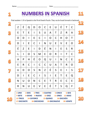
Find numbers 1-20 in Spanish in this Word Search Puzzle. They can be found forward or backward. 1 printable handout. Includes: uno, dos, tres, cuatro, cinco, seis, siete, ocho, nueve, diez, once, doce, trece, catorce, quince, dieciséis, diecisiete, dieciocho, diecinueve, veinte.
For numbers 1-20 in English, please visit: ENGLISH NUMBERS 1-20 WORD SEARCH PUZZLE.
Thanks so much for using my handouts in your classroom! I hope you find them useful. Reviews are welcome and very much appreciated. Please follow this store for more printables.
Introduce your students to the islands of the Caribbean with this printable activity! Instant download. Print and go!
Using the map of the Caribbean, find the Caribbean islands in the word search puzzle! They can be found forward or backward. List of Caribbean islands to find: Anguilla, Antigua and Barbuda, Aruba, Bahamas, Barbados, British Virgin Islands, Cayman Islands, Cuba, Dominica, Dominican Republic, Grenada, Guadeloupe, Haiti, Jamaica, Martinique, Montserrat, Navassa Island, Puerto Rico, Saint Barthelemy, Saint Kitts and Nevis, Saint Lucia, Saint Martin, Saint Vincent, Trinidad and Tobago, Turks and Caicos Islands, Virgin Islands.
One printable map/word search puzzle (plus answer key).
Thank you so much for using my worksheets in your classroom! I hope you find them useful. Reviews are welcome and very much appreciated! Please browse this store for more worksheets to introduce your learners to the countries of the world!
Introduce your learners to Ireland with this printable handout of two worksheets (plus answer key). Your students will read a brief overview of Ireland (location, capital, flag, language), write ‘Dublin’ next to the star on the map to show the location of the capital, color the small map and flag, and use the map and compass to answer 6 multiple-choice questions on page 2. Colored pencils or and a pen or pencil are needed for this activity. No other prep needed. Basic Geography worksheet with a simple map to introduce the country of Ireland.
For use with Interactive Notebooks: After completing the worksheets, students can cut out the map and flag and paste it into the notebook under the topic of Europe / Sub-Topic: Ireland. Under the map, students will write a summary in their own words of what they now know about this country. Collect worksheets for other countries of Europe to add to the notebook! Please browse this store for a selection of worksheets for other countries of Europe (and beyond!).
Thank you so much for using my Geography worksheets in your classroom! I hope you find them useful. Reviews are welcome and very much appreciated.
Introduce your learners to the regions of France with this printable activity!
Using the map of France, find the 18 regions in the Word Search Puzzle. 1 printable word search puzzle with map (plus answer key).
Regions of France to find in Word Search Puzzle:
Auvergne-Rhône-Alpes
Bourgogne-Franche-Comté
Bretagne
Centre-Val de Loire
Corse
Grand Est
Hauts-de-France
Ile-de-France
Normandie
Nouvelle-Aquitaine
Occitanie
Pays de la Loire
Provence–Alpes–Côte d’Azur
Guadeloupe
Guyane
La Réunion
Martinique
Mayotte
Thank you so much for using my worksheets in your classroom! I hope you find them useful. Reviews are welcome and very much appreciated! Please browse this store for a selection of printable worksheets with simple maps to introduce your students to the countries of the world!
Mexico is located south of the United States and north of Central America. Introduce your learners to Mexico and surrounding with this printable map activity! Two worksheets (plus answer key).
Page 1:
FILL IN THE BLANKS on the map for each of the following: Alabama, Arizona, Arkansas, Atlantic Ocean, Belize, California, Caribbean Sea, Costa Rica, Cuba, El Salvador, Florida, Georgia, Guatemala, Gulf of Mexico, Honduras, Louisiana, Mexico, Mississippi, New Mexico, Nicaragua, Oklahoma, Pacific Ocean, Panama, South Carolina, Texas.
COLOR CODE: Choose a color for the United States, Mexico, Central America, and Bodies of Water. Then color the map.
Page 2: Use your completed map and compass to answer 7 questions.
Page 3: Answer Key.
Colored pencils and a pen or pencil are needed for this activity. No other prep needed.
Thank you so much for using my printables with your learners! I hope you find them useful. Reviews are welcome and very much appreciated. Please browse this store for more worksheets to introduce your learners to the countries of the world!
Using the map, find the 17 regions of Spain in the Word Search Puzzle. 1 printable word search puzzle with map (plus answer key).
Regions of Spain to find in Word Search Puzzle:
Andalucía
Aragon
Asturias
Balearic Islands
Basque Country
Canary Islands
Cantabria
Castilla-La Mancha
Castilla Y Leon
Catalonia
Extremadura
Galicia
La Rioja
Madrid
Murcia
Navarra
Valencia
Thank you so much for using my worksheets in your classroom! I hope you find them useful. Reviews are welcome and very much appreciated! Please browse this store for a selection of Geography worksheets, word search puzzles and more!