Thank you for visiting! Here you will find a selection of printable, interactive worksheets for your classroom: Basic Geography worksheets with simple maps, ESL, Spanish, Bible, Reading Comprehension and more. I hope you find the resources useful! Reviews are welcome and very much appreciated. Thank you so much.
Thank you for visiting! Here you will find a selection of printable, interactive worksheets for your classroom: Basic Geography worksheets with simple maps, ESL, Spanish, Bible, Reading Comprehension and more. I hope you find the resources useful! Reviews are welcome and very much appreciated. Thank you so much.
Introduce your learners to Liechtenstein with two worksheets (plus answer key). Your learners will read a brief introduction to Liechtenstein (location, capital, flag, language), write ‘Vaduz’ next to the star on the map to show the location of the capital, color a small map, and use the map and compass to answer 7 multiple-choice questions on page 2. Colored pencils and a pen or pencil are needed for this activity. No other prep needed. Basic Geography worksheet with a simple map to introduce Liechtenstein and practice cardinal and ordinal directions.
For use with Interactive Notebooks: After completing the worksheets, students can cut out the map and flag and paste into the notebook under the topic of Europe/Sub-Topic: Liechtenstein. Under the map and flag, students can write a summary in their own words of what they now know about this country. Collect worksheets for other countries of Europe to add to the notebook! Please browse this store for worksheets for other countries of Europe (and beyond!)
Thank you so much for using my Geography worksheets in your classroom! I hope you find them useful. Reviews are welcome and very much appreciated!
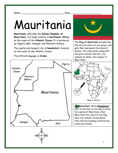
Introduce your students to the country of MAURITANIA in Africa with this printable handout of two worksheets (plus answer key). Your students will read a brief overview of Mauritania (location, capital, flag, language), write ‘Nouakchott’ next to the star on the map to show the capital, color the small map, and use the map and compass to answer 8 questions on page 2. Colored pencils and a pen or pencil are needed for this activity. No other prep needed. Basic Geography worksheet with a simple map to introduce the country of Mauritania and practice cardinal/ordinal directions.
For use with Interactive Notebooks: After the handout is completed, students can cut out the map and flag and paste into the notebook under the topic of Africa/Sub-topic: Mauritania. Under the map and flag, your students can write a summary in their own words of what they now know about this country. Collect handouts for other countries of Africa to add to the notebook! Please browse this store for a selection of printable handouts for other countries of Africa (and beyond!)
Thank you for using my Geography worksheets in your classroom!
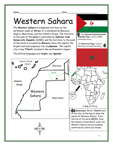
Introduce your students to the WESTERN SAHARA in Africa with two worksheets (plus answer key). Your students will read a brief introduction to Western Sahara (location, capital, flags, language), write ‘Tifariti’ next to the star on the map to show the capital, color the small map, and use the map and compass to answer 8 questions on page 2. Colored pencils and a pen or pencil are needed for this activity. No other prep needed. Basic Geography worksheet with a simple map to introduce the Western Sahara and practice cardinal/ordinal directions.
For use with Interactive Notebooks: After the worksheets are completed, students can cut out the map and flag and paste into the notebook under the topic of Africa/Sub-topic: Western Sahara. Under the map and flag, your students can write a summary in their own words of what they now know about Western Sahara. Collect worksheets for other countries of Africa to add to the notebook! Please browse this store for a selection of printable worksheets for all other countries of Africa (and beyond!).
Thank you for using my Geography worksheets in your classroom! I hope you find them useful. Reviews are welcome and very much appreciated!
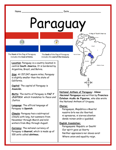
This printable handout includes a fact sheet about Paraguay (with basic info such as location, climate, language, currency, national motto), followed by a cloze activity/fill-in-the-blank page.
Thank you so much for using my worksheets in your classroom!
Introduce your students to the country of BURKINA FASO in West Africa with this printable handout of two worksheets (plus answer key). Your students will read a brief overview of Burkina Faso (location, capital, flag, language), write ‘Ouagadougou’ next to the star on the map to show the capital, color the small map, and use the map and compass to answer 9 questions on page 2. Colored pencils and a pen or pencil are needed for this activity. No other prep needed. Basic Geography worksheet with a simple map to introduce the country of Burkina Faso and practice cardinal/ordinal directions.
For use with Interactive Notebooks: After the handout is completed, students can cut out the map and flag and paste into the notebook under the topic of Africa/Sub-topic: Burkina Faso. Under the map and flag, your students can write a summary in their own words of what they now know about this country. Collect handouts for other countries of Africa to add to the notebook! Please browse this store for a selection of printable handouts for other countries of Africa (and beyond!).
Thanks so much for using my Geography worksheets in your classroom!
Introduce your students to the country of BURUNDI in the Great Lakes Region of Africa with this printable handout of two worksheets (plus answer key). Your students will read a brief introduction to Burundi (location, capital, flag, language), write ‘Gitega’ next to the star on the map to show the capital, trace Lake Tanganyika on the southwest border of Burundi, color the small map, and use the map and compass to answer 8 questions on page 2. Colored pencils and a pen or pencil are needed for this activity. No other prep needed. Basic Geography worksheet with a simple map to introduce the country of Burundi and practice cardinal/ordinal directions.
For use with Interactive Notebooks: After the worksheets are completed, students can cut out the map and flag and paste into the notebook under the topic of Africa/Sub-topic: Burundi. Under the map and flag, your students can write a summary in their own words of what they now know about this country. Collect worksheets for other countries of Africa to add to the notebook! Please browse this store for a selection of printable worksheets for all other countries of Africa (and beyond!).
Thank you so much for using my Geography worksheets in your classroom! I hope you find them useful. Reviews are welcome and very much appreciated!
Introduce your students to the country of GABON in West Africa with two worksheets (plus answer key). Your students will read a brief introduction to Gabon (location, capital, flag, language), write ‘Libreville’ next to the star on the map to show the capital, trace the line of the equator, color the small map, and use the map and compass to answer 8 questions on page 2. Colored pencils and a pen or pencil are needed for this activity. No other prep needed. Basic Geography worksheet with a simple map to introduce the country of Gabon and practice cardinal/ordinal directions.
For use with Interactive Notebooks: After the worksheets are completed, students can cut out the map and flag and paste into the notebook under the topic of Africa/Sub-topic: Gabon. Under the map and flag, your students can write a summary in their own words of what they now know about this country. Collect worksheets for other countries of Africa to add to the notebook! Please browse this store for a selection of printable handouts for other countries of Africa (and beyond!).
Thank you so much for using my Geography worksheets in your classroom! I hope you find them useful. Reviews are welcome and very much appreciated!
Introduce your students to the island country of COMOROS in Africa with this printable handout of two worksheets (plus answer key). Your students will read a brief introduction to Comoros (location, capital, flag, language), write ‘Maroni’ next to the star on the map to show the capital, color the small map, and use the map and compass to answer 8 questions on page 2. Colored pencils and a pen or pencil are needed for this activity. No other prep needed. Basic Geography worksheet with a simple map to introduce Comoros and practice cardinal and ordinal directions.
For use with Interactive Notebooks: After the worksheets are completed, students can cut out the map and flag and paste into the notebook under the topic of Africa/Sub-topic: Comoros. Under the map and flag, your students can write a summary in their own words of what they now know about this country. Collect worksheets for other countries of Africa to add to the notebook! Please browse this store for a selection of printable handouts for all other countries of Africa (and beyond!).
Thank you so much for using my Geography worksheets in your classroom! I hope you find them useful. Reviews are welcome and very much appreciated!
Included: Grande Comore, Mohéli, Anjouan, Mayotte, Mozambique, Madagascar, Indian Ocean.
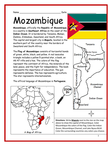
Introduce your students to the country of MOZAMBIQUE in Africa with this printable handout of two worksheets (plus answer key). Your students will read a brief introduction to Mozambique (location, capital, flag, language), write ‘Maputo’ next to the star on the map to show the capital, color the small map, and use the map and compass to answer 9 questions on page 2. Colored pencils and a pen or pencil are needed for this activity. No other prep needed. Basic Geography worksheet with a simple map to introduce Mozambique and practice cardinal and ordinal directions.
For use with Interactive Notebooks: After the worksheets are completed, students can cut out the map and flag and paste into the notebook under the topic of Africa/Sub-topic: Mozambique. Under the map and flag, your students can write a summary in their own words of what they now know about this country. Collect worksheets for other countries of Africa to add to the notebook! Please browse this store for a selection of printable worksheets for all other countries of Africa (and beyond!).
Thank you so much for using my Geography worksheets in your classroom! I hope you find them useful. Reviews are welcome and very much appreciated!
Introduce your students to the country of LESOTHO in Africa with two worksheets (plus answer key). Your students will read a brief introduction to Lesotho (location, capital, flag, language), write ‘Maseru’ next to the star on the map to show the location of the capital, trace the line of the Caledon River, color the small map, and use the map and compass to answer 6 multiple-choice questions on page 2. Colored pencils and a pen or pencil are needed for this activity. No other prep needed. Basic Geography worksheet with a simple map to introduce the country of Lesotho.
For use with Interactive Notebooks: After the worksheets are completed, students can cut out the map and flag and paste into the notebook under the topic of Africa/Sub-topic: Lesotho. Under the map and flag, your students can write a summary in their own words of what they now know about this country. Collect worksheets for other countries of Africa to add to the notebook! Please browse this store for a selection of printable handouts for all other countries of Africa (and beyond!)
Thank you so much for using my Geography worksheets in your classroom! I hope you find them useful. Reviews are welcome and very much appreciated!
Introduce your students to CAPE VERDE, the island country in the Atlantic Ocean off the coast of West Africa, with this printable handout of two worksheets (plus answer key). Your students will read a brief introduction to Cape Verde (location, capital, flag, language), write ‘Praia’ next to the star on the map to show the capital, color the small map, and use the map and compass to answer 8 questions on page 2. Colored pencils and a pen or pencil are needed for this activity. No other prep needed. Basic Geography worksheet with a simple map to introduce the African country of Cape Verde.
For use with Interactive Notebooks: After the worksheets are completed, students can cut out the map and flag and paste into the notebook under the topic of Africa/Sub-topic: Cape Verde. Under the map and flag, your students can write a summary in their own words of what they now know about this country. Collect worksheets for other countries of Africa to add to the notebook! Please browse this store for a selection of printable Geography worksheets for all other countries of Africa (and beyond!).
Thank you so much for using my Geography worksheets in your classroom! I hope you find them useful. Reviews are welcome and very much appreciated.
Included: Barlavento Islands: Santo Antão, São Vicente, Santa Luzia, São Nicolau, Sal, Boa Vista. Sotavento Islands: Maio, Santiago, Fogo, Brava. Senegal, Mauritania, The Gambia
Introduce your students to the island country of São Tomé and Príncipe in Africa with this printable handout of two worksheets (plus answer key). Your students will read a brief overview of São Tomé and Príncipe (location, capital, flag, language), write ‘São Tomé’ next to the star on the map to show the capital, trace the line of the equator, color the small map, and use the map and compass to answer 8 questions on page 2. Colored pencils and a pen or pencil are needed for this activity. No other prep needed. Basic Geography worksheet with a simple map to introduce São Tomé and Príncipe and practice cardinal and ordinal directions.
For use with Interactive Notebooks: After the handout is completed, students can cut out the map and flag and paste into the notebook under the topic of Africa/Sub-topic: São Tomé and Príncipe. Under the map and flag, your students can write a summary in their own words of what they now know about this country. Collect handouts for other countries of Africa to add to the notebook. Please browse this store for a selection of printable handouts for other countries of Africa (and beyond!).
Thank you so much for using my Geography worksheets in your classroom!
Rôlas, Caroço, Tinhosas, Portuguese
Introduce your students to the island country of MAURITIUS in Africa with two worksheets (plus answer key). Your students will read a brief introduction to Mauritius (location, capital, flag, language), write ‘Port Louis’ next to the star on the map to show the capital, color the small map, and use the map and compass to answer 8 questions on page 2. Colored pencils and a pen or pencil are needed for this activity. No other prep needed. Basic Geography worksheet with a simple map to introduce Mauritius and practice cardinal and ordinal directions.
For use with Interactive Notebooks: After the worksheets are completed, students can cut out the map and flag and paste into the notebook under the topic of Africa/Sub-topic: Mauritius. Under the map and flag, your students can write a summary in their own words of what they now know about this country. Collect worksheets for other countries of Africa to add to the notebook! Please browse this store for worksheets for other countries of Africa (and beyond!)
Thank you so much for using my Geography worksheets in your classroom! I hope you find them useful. Reviews are welcome and very much appreciated!
Mascarene Islands, Rodrigues, Réunion, Agaléga, Indian Ocean, Madagascar.
Introduce your students to the country of ESWATINI, formerly known as SWAZILAND in Africa with this printable handout of two worksheets (plus answer key). Your students will read a brief introduction to Eswatini (location, capital, flag, language), write ‘Mbabane and Lobamba’ next to the stars on the map to show the two capitals, color the small map, and use the map and compass to answer 7 questions on page 2. Colored pencils and a pen or pencil are needed for this activity. No other prep needed. Basic Geography worksheet with a simple map to introduce Eswatini/Swaziland and practice cardinal and ordinal directions.
For use with Interactive Notebooks: After the worksheets are completed, students can cut out the map and flag and paste into the notebook under the topic of Africa/Sub-topic: Eswatini. Under the map and flag, your students can write a summary in their own words of what they now know about this country. Collect worksheets for other countries of Africa to add to the notebook! Please browse this store for a selection of printable handouts for all other countries of Africa (and beyond!).
Thank you for using my Geography worksheets in your classroom! I hope you find them useful. Reviews are welcome and very much appreciated!
Introduce your learners to the U.S. state of KANSAS with two worksheets (plus answer key). Your students will read a brief introduction to Kansas (location, capital, flag, state bird, state flower), write ‘Topeka’ next to the star on the map to show the location of the capital, trace the line of the Kansas River blue, color the small map of Kansas and surrounding states, color the state bird and state flower (Western Meadowlark and Sunflower) and use the map and compass to answer 9 questions on page 2. Colored pencils and a pen or pencil are needed for this activity. No other prep needed. Basic Geography worksheet with a simple map to introduce the state of Kansas and practice cardinal and ordinal directions.
For use with Interactive Notebooks: After the worksheets are completed, students can cut out the map, flag, state bird and state flower, and paste into the notebook under the topic of United States / Sub-Topic: Kansas. Under the map, students can write a summary in their own words of what they now know about this state. Collect worksheets for all U.S. states to add to notebook! Please browse this store for worksheets for other states of the USA (and beyond!).
Thank you so much for using my Geography worksheets in your classroom! I hope you find them useful. Reviews are welcome and very much appreciated.
Wichita, 34th state, Kansa Native Americans, Midwestern region, Nebraska, Missouri, Oklahoma, Colorado, Sunflower, Western Meadowlark
Introduce your learners to the country of Samoa in Oceania with two interactive worksheets (plus answer key). Your students will read a brief introduction to Samoa (location, capital, flag, language), locate and circle Samoa on the map of Oceania, write ‘Apia’ next to the star on the map of Samoa to show the location of the capital, color the small map, and use the map and compass to answer 7 multiple-choice questions on page 2. Colored pencils and a pen or pencil are needed for this activity. No other prep needed. Basic Geography worksheet with a simple map to introduce Samoa and practice cardinal and ordinal directions.
For use with Interactive Notebooks: After your students complete the worksheets, they can cut out the map and flag and paste into the notebook under the topic of (example) Oceania/Sub-Topic: Samoa. Under the map and flag, students can write a summary in their own words of what they now know about Samoa. Collect worksheets for other countries of Oceania to add to the notebook! Please browse this store for a selection of worksheets for other countries of Oceania (and beyond!).
Thank you so much for using my Geography worksheets in your classroom! I hope you find them useful and fun. Reviews are welcome and very much appreciated.
Introduce your learners to the U.S. state of WASHINGTON with two worksheets (plus answer key). Your students will read a brief introduction to Washington (location, capital, flag, state bird, state flower), write ‘Olympia’ next to the star on the map to show the capital, color the small map, state bird (American Goldfinch) and state bird (Rhododendron), and use the map and compass to answer 9 questions on page 2. Colored pencils and a pen or pencil are needed for this activity. No other prep needed. Basic Geography worksheet with a simple map to introduce the state of Washington and practice cardinal and ordinal directions.
For use with Interactive Notebooks: After the worksheets are completed, students can cut out the map, flag, state bird and state flower, and paste into the notebook under the topic of United States/Sub-Topic: Washington. Under the map, students can write a summary in their own words of what they now know about this state. Collect worksheets for all U.S. states to add to notebook! Please browse this store for a selection of printable Geography worksheets for all 50 states of the USA!
Thank you so much for using my Geography worksheets in your classroom. I hope you find them useful. Reviews are welcome and very much appreciated.
Included on map: Oregon, Idaho, Canada, Pacific Ocean, Seattle, State Seal.
Introduce your learners to the country of Kyrgyzstan in Central Asia with this printable handout of two worksheets (plus answer key). Printable or digital. Your students will read a brief overview of Kyrgyzstan (location, capital, language, flag), write ‘Bishkek’ next to the star on the map to show the capital, color the small map, and use the map and compass to answer 8 true/false questions on page 2. Colored pencils and a pen or pencil are needed for this activity. No other prep needed. Basic Geography worksheet with a simple map to introduce the country of Kyrgyzstan and practice cardinal and ordinal directions.
For use with Interactive Notebooks: After your students complete the worksheets, they can cut out the map and flag of Kyrgyzstan and paste into the notebook under the topic of Asia / Sub-topic: Kyrgyzstan. Under the map, students can write a summary in their own words of what they now know about this country. Collect worksheets for other countries of Asia to add to the notebook! Please browse this store for a selection of worksheets for other countries of Asia (and beyond!).
Thank you so much for using my Geography worksheets in your classroom! Reviews are welcome and very much appreciated.
Included: Kazakhstan, Uzbekistan, Tajikistan, China, Yurt, Manas, Kyrgyz and Russian.
Introduce your learners to the country of LAOS in Asia with this printable handout of two worksheets (plus answer key). Your students will read a brief overview of Laos (location, capital, language, flag), write ‘Vientiane’ next to the star on the map to show the capital, color the small map, and use the map and compass to answer 8 true/false questions on page 2. Colored pencils and a pen or pencil are needed for this activity. No other prep needed. Basic Geography worksheet with a simple map to introduce the country of Laos and practice cardinal and ordinal directions.
For use with Interactive Notebooks: After your students complete the worksheets, they can cut out the map and flag of Laos and paste into the notebook under the topic of Asia / Sub-topic: Laos. Under the map, students can write a summary in their own words of what they now know about this country. Collect worksheets for other countries of Asia to add to the notebook! Please browse this store for a selection of printable worksheets for other countries of Asia (and beyond!).
Thank you so much for using my Geography worksheets in your classroom! I hope you find them useful and fun. Reviews are welcome and very much appreciated!
Introduce your learners to the state of NEW MEXICO in the USA with this printable handout of two worksheets (plus answer key). Your students will read a brief overview of New Mexico (location, capital, flag, state bird, state flower), write ‘Santa Fe’ next to the star on the map to show the location of the capital, color the small map, and use the map and compass to answer 10 true/false questions on page 2. Colored pencils and a pen or pencil are needed for this activity. No other prep needed. Basic Geography worksheet with a simple map to introduce New Mexico and practice cardinal and ordinal directions.
For use with Interactive Notebooks: After the worksheets are completed, students can cut out the map and flag of New Mexico and paste into the notebook under the topic of United States/Sub-Topic: New Mexico. Under the map, students can write a summary in their own words of what they now know about this state. Collect worksheets for other states of the US to add to the notebook! Please browse this store for a selection of worksheets for other states of the USA (and beyond!).
Thank you so much for using my worksheets in your classroom! Reviews are welcome and very much appreciated.
Included: Colorado, Oklahoma, Texas, Arizona, Mexico, Albuquerque, Greater Roadrunner, Yucca Flower, Zia sun symbol, Land of Enchantment, southwestern region.