EUROPEAN DAYS OF LANGUAGES QUIZ EUROPEAN COUNTRIES AND CAPITAL CITIES - 2 QUIZZES WITH 120 MULTIPLE-CHOICE QUESTIONS
Files are non-editable in a zipped format. The produce is copyright, all rights reserved. It may not be copied, rewritten, amended, shared or distributed outside your own classroom in any way. The license for purchase is a single-user license only. Please read the Terms of Use carefully.
Ideal multiple-choice quizzes for the European Day of Languages. Students can develop their knowledge of Europe in a cooperative, communicative and interactive way, independently of the teacher. Play both as a whole-group team quiz, or in pairs / small groups on a regular basis - students are particularly keen to see if they can beat their own points record, and are really motivated by their developing knowledge.
The set contains all European countries and capital cities, including some island communities such as the Faroe Islands and Guernsey. Each question has 4 answers to choose from. The correct answer is given in capital letters. The quiz cards are numbered, but questions can be asked in random order too: simply place all the cards in a bowl, box or tin, and work your way through.
There are two quiz challenges:
Challenge 1 gives the country as a prompt, with four possible capital cities to choose from.
Challenge 2 gives the capital city as a prompt, with four possible countries to choose from.
The card numbers for Challenge 1 are in the top right-hand corner; Challenge 2 in the top left-hand corner so that the cards can be organised and sorted easily. Laminate the cards if possible: they’re more learner-friendly, and remain in excellent condition for years.
Please note this is the European Day of Languages Europe Countries & Capitals quizzes edition of our Geography Europe Countries & Capitals quizzes - please ensure you have not already purchased the Geography edition.
Before playing, it’s useful to show students a clear map of Europe, so that they can visualise the location of each country and capital city, not only as an individual location with Europe, but also as a location in relation to other European countries and capital cities. This definitely helps students understand and memorise the countries and capital cities.
Have a browse in my store for more European Day of Languages resources and activities!
THANK YOU AND ENJOY THE EUROPEAN DAY OF LANGUAGES!
EUROPEAN DAY OF LANGUAGES EUROPE COUNTRIES CAPITAL CITIES FLAGS PRESENTATION & QUIZ
The resource is non-editable in a zipped format. It may not be copied, rewritten, shared or distributed outside your own classroom in any way. The license for purchase is a single-user license only. Please read the Terms of Use.
An instant introduction to Europe which really helps students develop their awareness of European countries, capital cities and flags. There are***60 countries*** featured in the quiz. Each country is presented individually with its capital city and flag - as you show the slides, encourage students to shout out the country names as they appear - this tends to aid memory quite considerably - I point out the location of each country on the background map, which helps students situate each country within the continent, and visualizing the location of the countries again aids memory.
The presentation is followed by a series of 100 questions. The questions are structured slightly differently to differentiate the challenge a little: some focus on the countries, others on capital cities, and some on flags. Taken together, students will definitely develop a sound locational knowledge of the countries of Europe, their capital cities and flags.
The quiz works particularly well with several teams - encourage each team to choose a European-themed team game. Teams can either take it in turns to answer a question, but it’s also great fun, and keeps up a lively pace, to play as a Shout it out! quiz - whoever shouts out the correct answer first wins the point.
The resource is not editable for copyright reasons - the presentation moves on with a click. Each question slide is followed by the relevant answer slide - simply click, and it appears!
Please note this is the European Day of Languages edition of my Geography Europe Presentation & Quiz - please ensure you have not already purchased the geography edition
Have a browse in my store for more European Day of Languages resources!
THANKS AND HAVE A GREAT EUROPEAN DAY OF LANGUAGES!
EUROPEAN DAY OF LANGUAGES EUROPE COUNTRIES & CAPITAL CITIES LIST FREEBIE
The resource is non-editable in a zipped format. It is copyright, all rights reserved. It may not be copied, rewritten, shared or distributed outside your own classroom in any way. The available license is a single-user license only. Please read the Terms of Use. The resource is free to download, but Terms of Use still apply.
Ideal reference resource, also useful for quizzes, guessing games and team competitions across the school year, but especially on the European Day of Languages - a great teacher time-saver too, if you’re preparing resources on Europe, its countries and capital cities, the list will save you a ton of time!
Have a browse in my store for more European Day of Languages resources and activities!
THANKS AND ENJOY YOUR EUROPEAN DAY OF LANGUAGES!
EUROPEAN DAY OF LANGUAGES
THIS RESOURCE IS BEING UPDATED AND IS NOT CURRENTLY FOR SALE. PLEASE CHECK BACK SOON FOR THE REVISED EDITION
Files are non-editable in a zipped format. Please read the Terms of Use carefully - the resource is copyright, all rights reserved. It may not be copied, rewritten, shared or distributed in any way. The license for purchase is a single-user license only.
THANKS AND ENJOY THE EUROPEAN DAY OF LANGUAGES!
EUROPEAN DAY OF LANGUAGES EUROPE COUNTRIES AND FLAGS I HAVE, WHO HAS? GAME
The resource is non-editable in a zipped format It is copyright, with all rights reserved. It may not be copied, rewritten, shared or distributed outside your own classroom in any way. The user license for purchase is a single-user license only. School licences are available. Please read the Terms of Use carefully.
Ideal whole-group communicative game for the European Days of Languages. The repetitive nature of the questions and answers, supported by the visual prompt of the flags, makes it perfect for learning the countries of Europe and their national flags.
The aim of the game is to make an alphabetical country line as quickly as possible, starting with the first card, Albania, and ending with the final card, Wales. Students will probably have several cards each, depending on the size of your group. Playing in teams against a timer adds a very popular competitive edge, and you will need a couple of sets of cards, depending on the size of your group. I generally start with a rapid whole-group warm-up, asking simple questions such as How many European countries can you name in 15 seconds? and so on.
Laminate the cards if you can, as they are more learner-friendly, and remain in excellent condition for years, so you’ll get lots of use from them. There are six cards per A4 (8.5x11) landscape, 60 cards in total.
Have a browse in my store for more European Day of Languages resources and activities!
THANKS AND HAVE A GREAT EUROPEAN DAY OF LANGUAGES!
GEOGRAPHY AFRICAN COUNTRIES & CAPITAL CITIES REFERENCE LIST A great addition to student learning files - my students find reference resources really useful - they also work well printed double-sided and laminated as a classroom reference resource, or printed single-sided and glued into reference books.
The resource is non-editable in a zipped format. The resource is free to download, but remains copyright, all rights reserved - it may not be copied, rewritten, shared or distributed in any way - please read the Terms of Use.
THANKS AND ENJOY YOUR TRIP AROUND AFRICA!
KS4 GEOGRAPHY KS3 GEOGRAPHY USA STATES AND STATE CAPITALS GEOGRAPHY AMERICAN STATES AND CAPITALS FOUR MULTIPLE-CHOICE QUIZZES
***Files are non-editable in a zipped format. The product is copyright, all rights reserved. It may not be copied, rewritten, shared or distributed outside your own classroom in any way. The license is a single-user licence only. Please read the Terms of Use. ***
Perfect for geography class, as well as a general knowledge quiz: an ideal way for students to learn and test their knowledge of the states and capitals of the USA. There are four multiple choice quizzes, each question with four possible answers to choose from, 160 individual questions in total. The correct answer is given in capital letters.
The quizzes work well as a whole, small-group or paired oral quiz. Each quiz card is numbered in a particular place according to the particular quiz, so that the cards can be easily sorted and organised before and after playing. Laminate if you can - it’s definitely worth the extra prep time and expense, as they cards are more learner-friendly and remain in excellent condition for years, so you’ll get lots of use from them.
Quiz Challenge 1: The capital of… is… (4 choices, 50 questions)
Quiz Challenge 2: … is the capital of… (4 choices, 50 questions)
Quiz Challenge 3: True or false: The capital of… is… (4 choices, 30 questions) - where the answer is false, students should also give the correct answer
Quiz Challenge 4: True or false: … is the capital of… (4 choices, 30 questions) - where the answer is false, students should also give the correct answer
Have a browse in my store for more Geography resources, including special offer bundles and freebies.
THANK YOU AND ENJOY THE QUIZZES!
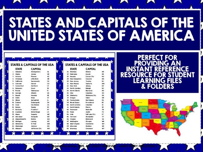
50 STATES AND CAPITALS OF THE UNITED STATES OF AMERICA IN ALPHABETICAL ORDER
A great addition to student learning files - my students find reference resources really useful - they also work well printed double-sided and laminated as a classroom reference resource, or printed single-sided and glued into reference books
Please read the Terms of Use carefully - the resource is free to download, but remains copyright - thanks!
KS3 GEOGRAPHY EUROPE KS4 GEOGRAPHY EUROPE EUROPEAN COUNTRIES AND CAPITAL CITIES LIST
***The resource is non-editable in a zipped format. It is copyright, all rights reserved. It may not be copied, rewritten, amended, shared or distributed outside your own classroom in any way. The resource is free to download, but Terms of Use still apply. ***
Features all European countries and capital cities, including some island communities such as the Faroe Islands and Guernsey. There are several countries, for example Armenia, that are often classed as belonging either to Europe or to Asia.
There are more Europe resources here:
GEOGRAPHY EUROPEAN COUNTRIES, CAPITALS & FLAGS CARDS
https://www.tes.com/teaching-resource/geography-europe-country-cards-11121610
GEOGRAPHY EUROPEAN COUNTRIES, CAPITALS & FLAGS POSTERS
https://www.tes.com/teaching-resource/geography-europe-countries-capitals-flags-posters-11473492
GEOGRAPHY EUROPEAN COUNTRIES, CAPITALS & FLAGS PRESENTATION & QUIZ
https://www.tes.com/teaching-resource/geography-europe-countries-capitals-flags-presentation-and-quiz-11982609
GEOGRAPHY EUROPEAN COUNTRIES & CAPITALS QUIZZES
https://www.tes.com/teaching-resource/geography-europe-countries-and-capitals-2-multiple-choice-quizzes-12128928
Have a browse in my store for more world geography resources, with special offer bundles and freebies.
THANKS AND ENJOY YOUR TRIP AROUND EUROPE!
KS3 GEOGRAPHY EUROPE KS4 GEOGRAPHY EUROPE COUNTRIES AND CAPITAL CITIES EUROPE TWO MULTIPLE-CHOICE QUIZZES
Files are non-editable in a zipped format. The produce is copyright, all rights reserved. It may not be copied, rewritten, amended, shared or distributed outside your own classroom in any way. The license for purchase is a single-user license only. Please read the Terms of Use carefully.
Students can develop their knowledge of the geography of Europe in a cooperative, communicative and interactive way, independently of the teacher. We play both as a whole-group team quiz, and in pairs or small groups on a regular basis - students are particularly keen to see if they can beat their own points record, and are really motivated by their developing knowledge.
The set contains all European countries and capital cities, including some island communities such as the Faroe Islands and Guernsey. Each question has 4 answers to choose from. The correct answer is given in capital letters. The quiz cards are numbered, but questions can be asked in random order too: simply place all the cards in a bowl, box or tin, and work your way through.
There are two quiz challenges:
Challenge 1 gives the country as a prompt, with four possible capital cities to choose from.
Challenge 2 gives the capital city as a prompt, with four possible countries to choose from.
The card numbers for Challenge 1 are in the top right-hand corner; Challenge 2 in the top left-hand corner so that the cards can be organised and sorted easily. Laminate the cards if possible: they’re more learner-friendly, and remain in excellent condition for years.
Before playing, it’s useful to show students a map of Europe, so that they can visualize the location of each country and capital city, not only as an individual location with Europe, but also as a location in relation to other European countries and capital cities. This definitely helps students understand and memorise the countries and capital cities.
Have a browse in my store for more Geography resources, including special offer bundles and freebies.
THANKS AND ENJOY THE QUIZZES!
Please note this is the Geography World Continents Europe Countries & Capitals Quizzes version of my European Day of Languages Europe Countries & Capital Cities quizzes - please ensure you have not already purchased the European Day of Languages version.
PRIMARY FRENCH VOCABULARY KS3 FRENCH VOCABULARY BEGINNER FRENCH VOCABULARY CARDS FIVE SETS @ £2.95 EACH IN THE BUNDLE 990 matching French and English games cards with two Reference, Recall & Write Workbooks, focusing on 495 beginner French words and phrases.
Files are non-editable n a zipped format. Please read the Terms of Use - the resource is copyright, all rights reserved. It may not be copied, rewritten, shared or distributed outside your own classroom in any way. The license for purchase is a single-user license only.
The vocabulary groups are as follows:
=Les salutations
=Les jours de la semaine
=Les mois et les saisons de l’année
=Les nombres 0-100
=Ma famille
=Les animaux
=Les matières scolaires
=Les fruits et légumes
=Les couleurs
=Les parties du corps
=Le temps
=Les pays
=Quelle heure est-il? (o’clock/half past)
=Les adjectifs
=La nourriture et les boissons
=Verbes français
=En ville
=Mots fréquents
=Le français pour la salle de classe
=Bavardons ensemble ! Conversation
=Questions et réponses
My students really like to work independently, in pairs and in small groups, and these vocabulary cards enable them to do that. There are lots of games and activities to play, and I’ve described several that are successful with my groups. I’ve found that giving students regular and frequent opportunities to play with the cards, not only when we’re focusing on these particular vocab groups, but across the school year, and even when they’re far more advanced in their learning - all learners benefit from going back to the start! There’s definitely some prep involved - printing, laminating and cutting out - laminating is certainly worth the effort, as the cards are a lot more learner-friendly, and do last for years. Students don’t have to play with full sets - they can work with selected vocab groups.
There is an 18-page workbook for each set, which gives students a different way of consolidating their vocabulary - writing it out really helps to embed language, and is great for spelling too. There are 3 differentiated recall and write challenges, as well as a full alphabetical French-English vocabulary list, which works well as a longer-term reference resource too. My students learn a lot from applying their French practically with the game card templates - they enjoy creating cards for each other. I use the workbook for homework, holiday work, practice and revision or cover lessons - they’re really versatile.
Written Recall Challenge One: students write the English word / phrase from a French prompt, with all the words and phrases grouped together in the same category
Written Recall Challenge Two: with this challenge, students write the words / phrases in French from an English prompt, and again, they’re all group together in the same category
Written Recall Challenge Three: this final challenge ‘switches’ at each question from French to English, and lists words and phrases randomly from each category - I’ve found that this really does encourage my students to think hard about their French vocab.
Have a browse in my store for more French independent learning activities, and a wide range of other French teaching and learning resources, with French resource boxes, special offer bundles, and lots of freebies - I’ve included a couple here for you to try.
MERCI BEAUCOUP ET BON APPRENTISSAGE !
KS3 GEOGRAPHY KS4 EUROPE COUNTRIES CAPITAL CITIES FLAGS PRESENTATION & QUIZ
The resource is non-editable for copyright reasons, and is in a zipped format. It may not be copied, rewritten, shared or distributed outside your own classroom in any way. The license for purchase is a single-user license only. Please read the Terms of Use.
An ideal introduction to Europe, helping students develop their awareness of European countries, capital cities and flags.
There are 60 countries featured in the quiz. Each country is presented individually with its capital city and flag - as you show the slides, encourage students to shout out the country names as they appear - this tends to aid memory quite considerably - I point out the location of each country on the background map, which helps students situate each country within the continent, and visualizing the location of the countries again aids memory.
The presentation is followed by a series of 100 questions. The questions are structured slightly differently to differentiate the challenge a little: some focus on the countries, others on capital cities, and some on flags. Taken together, students will definitely develop a sound locational knowledge of the countries of Europe, their capital cities and flags.
The quiz works particularly well with several teams - encourage each team to choose a***European-themed team game***. Teams can either take it in turns to answer a question, but it’s also great fun, and keeps up a lively pace, to play as a Shout it out! quiz - whoever shouts out the correct answer first wins the point. The quiz works really well across the entire school year, and not just in geography or social science lessons - it’s really popular in form time too!.
The presentation moves on with a click. Each question slide is followed by the relevant answer slide - simply click, and it appears! The resource cannot be edited due to copyright and licensing restrictions of the fonts and clipart.
Please note this is the Geography World Continents Europe Presentation & Quiz version of my European Day of Languages Europe Presentation & Quiz - please ensure you have not already purchased the European Day of Languages version.
THANKS AND ENJOY YOUR JOURNEY AROUND EUROPE!
GEOGRAPHY AFRICA COUNTRIES, CAPITAL CITIES & FLAGS GAMES CARDS
NEWLY-REVISED AND UPDATED RESOURCE COMING SOON - THIS PRODUCT IS CURRENTLY NOT FOR PURCHASE
perfect for developing knowledge and locational understanding of Africa the game cards provide great learning opportunities for any appropriate age group, at any time of the school year! Students can develop their knowledge of the geography of Africa in a cooperative, communicative and interactive way, independently of the teacher. There are 54 flag cards, and 54 country with capital city cards, featuring all African countries, capital cities and flags. There are also detachable country, capital cities and country & capitals together labels that students use to label the flags - labeling the flags with their respective countries and capitals is a really good way of consolidating learning.
There may be a number of countries and capital cities that students do not know, or are not aware of, so the games help them fully develop their general awareness, knowledge and understanding of Africa, its capital cities, and its flags. The cards use the current formal names of countries, such as Gabonese Republic, and I’ve used the more common Gabon on the labels, as I’ve found that this helps learners familiarize themselves with both names.
There is a country, capital city and flag reference list of all countries and capitals, which students find useful to read through before playing - allow them only 60 seconds on a timer to really focus their reading and increase the sense of competition if you are playing competitive team games! It can also be used as a year-round reference resource, which students can file in their workbooks or learning folders. Laminate the cards and reference sheets if you can - you will be able to use them for years to come. The games work best if played regularly and frequently, as this consolidates learning really successfully, and students love to see if they can beat their own time record.
Laminate the cards, labels and reference sheets if you can - it’s definitely a lot of prep, but it’s well worth it, as not only are the materials far more learner-friendly, they also last for absolutely years.
The resource is non-editable in a zipped format. It is copyright, all rights reserved. It may not be copied, rewritten, shared or distributed outside your own classroom in any way. The license for purchase is a single-user license only. Please read the Terms of Use carefully.
THANKS AND WELCOME TO AFRICA!
AFRICA GEOGRAPHY KS3 GEOGRAPHY KS4 GEOGRAPHY AFRICA AFRICAN COUNTRIES, CAPITAL CITIES AND FLAGS POSTERS / FLASHCARDS an instant and comprehensive introduction to Africa perfect for developing knowledge of world countries and continents
Files are non-editable in a zipped format. The produce is copyright, all rights reserved. It may not be copied, rewritten, amended, shared or distributed outside your own classroom in any way. The license for purchase is a single-user license only. Please read the Terms of Use carefully.
This kind of classroom decor provides a real learning opportunity in geography class, and this set is also a great visual prompt when you are discussing world geography in general, and Africa in particular. There may be a number of countries and capital cities that students do not know, or are not aware of, so the posters help students develop their general awareness, knowledge and understanding of Africa and its geography. It's useful to show students a clear map of Africa, so that students can visualise the location of each country and capital city, not only as an individual location with Africa, but also as a location in relation to other African countries and capital cities.
There are two formats to choose from - Africa map background or plain without frame. I laminate my classroom learning decor, even though it's extra prep time and expense. The posters display better, as flashcards they're a lot easier to manipulate, and they do remain in excellent condition for years, so you'll be able to recycle them many times.
The posters work just as well in the world languages classroom as well as the geography classroom, aligning learning between language and knowledge of the world.
Have a browse in my store for more world geography resources, with special offer bundles and lots of freebies.
THANKS AND HAVE A GREAT TRIP AROUND AFRICA!
GEOGRAPHY EUROPE EUROPEAN COUNTRIES, CAPITAL CITIES AND FLAGS POSTERS / FLASHCARDS an instant and comprehensive introduction to Europe perfect for developing knowledge of world countries and continents.
Files are non-editable in a zipped format. The produce is copyright, all rights reserved. It may not be copied, rewritten, amended, shared or distributed outside your own classroom in any way. The license for purchase is a single-user license only. Please read the Terms of Use carefully.
This kind of classroom decor provides a real learning opportunity in geography class, and this set is also a great visual prompt when you are discussing world geography in general, and Europe in particular. There may be a number of countries and capital cities that students do not know, or are not aware of, so the posters help students develop their general awareness, knowledge and understanding of Europe and its geography. It's useful to show students a clear map of Europe, so that students can visualise the location of each country and capital city, not only as an individual location with Europe, but also as a location in relation to other European countries and capital cities.
There are two formats to choose from - Europe map or plain without frame. I laminate my classroom learning decor, even though it's extra prep time and expense. The posters display better, as flashcards they're a lot easier to manipulate, and they do remain in excellent condition for years, so you'll be able to recycle them many times.
Have a browse in my store for more world geography resources, with special offer bundles and lots of freebies.
THANKS AND HAVE A GREAT TRIP AROUND EUROPE!
GCSE GERMAN KS4 GERMAN KS3 GERMAN KS5 GERMAN EUROPEAN COUNTRIES, CAPITAL CITIES, FLAGS POSTERS
Files are non-editable in zipped format. The product is copyright, all rights reserved. It may not be copied, amended, rewritten, shared or distributed outside your own classroom in any way. The license for purchase is a single-user license only. Please read the Terms of Use carefully.
These German Europe flashcards / posters are always really popular with my students and great for the beginning of a new school year to decorate your learning environment with specific learning goals. They’re really useful for creating and instant and comprehensive introduction to Europe in German. There are 144 portrait posters (A4, 8.5 x 11) in German showing European countries, capital cities and flags. They give your classroom a great multicultural look and feel, at the same time promoting German as a living language, featuring in the everyday life of your - and your students’ - classroom. There may be a number of countries and capital cities that students do not know, or are not aware of, so the posters can help students develop their general knowledge and understanding of European geography.
I’ve included a range of islands, such as the Faroe Islands, to extend students’ knowledge of Europe a little further, and I’ve also shown some countries, for example Armenia, that are often classed as belonging either to Europe or to Asia. I’ve also included two posters for some countries, such as France, officially known as Französische Republik - you can choose either that, or the more frequently-used Frankreich to display.
The posters look great displayed horizontally across a particular learning area - alphabetically works well, though non-alphabetically is perfect for a country quest activity. They’re ideal for the annual Europe Day celebration, and the European Day of Languages, as well as an all year round display. It’s definitely extra prep and expense, but I do always laminate my classroom display posters / flashcards - they hang on the walls more easily, and I recycle them to display at different times of the school year. There are two backgrounds to choose from - World Map or plain, so 144 posters in total.
My students find this Europe countries and capitals list freebie helpful:
https://www.tes.com/teaching-resource/german-europe-countries-and-capitals-list-freebie-12133858
Have a browse in my store for more German resources, including German cross-curricular resources, special offer bundles and freebies.
VIELEN DANK UND SCHÖNE REISE!
KS3 GEOGRAPHY KS4 EUROPE COUNTRIES, CAPITAL CITIES & FLAGS GAMES CARDS perfect for developing knowledge and locational understanding of Europe the game cards provide great learning opportunities for any appropriate age group, at any time of the school year! Students can develop their knowledge of the geography of Europe in a cooperative, communicative and interactive way, independently of the teacher.
There are 60 flag cards, and 60 country with capital city cards, featuring all European countries, capital cities and flags. There may be a number of countries and capital cities that students do not know, or are not aware of, so the games help them fully develop their general awareness, knowledge and understanding of Europe. I’ve also included a range of islands, such as the Faroe Islands, to extend students’ knowledge of Europe a little further, as well as several countries, for example Armenia, that are often classed as belonging either to Europe or to Asia. Great as a regular starter, refresher or plenary activity at any time of the school to really embed knowledge, as well as being a core learning resource when introducing Europe - playing in teams against a timer is really popular - students love to see if they can beat their own time record.
There is a country, capital city and flag reference list of all countries and capitals, which students find useful to read through before playing - allow them only 60 seconds on a timer to really focus their reading and increase the sense of competition if you are playing competitive team games! It can also be used as a year-round reference resource, which students can file in their workbooks or learning folders. There is also a full set of country and capital labels - labeling the flags with their respective countries and capitals is a really good way of consolidating learning. Laminate the cards, labels and reference sheets if you can - it’s definitely a lot of prep, but it’s well worth it, as not only are the materials far more learner-friendly, they also last for absolutely years.
The resource is non-editable in a zipped format. It is copyright, all rights reserved. It may not be copied, rewritten, shared or distributed in any way. The license for purchase is a single-user license only. Please read the Terms of Use carefully.
THANK YOU AND WELCOME TO EUROPE!