Creative and innovative resources that meet the needs of every learner in every lesson.
Why create numerous resources when one can do it all.
Most resources are for geography lessons, but many are for whole-school too and cross over into numerous subjects.
Creative and innovative resources that meet the needs of every learner in every lesson.
Why create numerous resources when one can do it all.
Most resources are for geography lessons, but many are for whole-school too and cross over into numerous subjects.
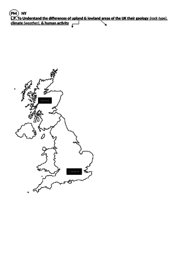
All the resources needed to teach pupils about the uses and characteristics of upland & lowland areas in the UK.
Pupils create an overlay (see video). This is a nice way to introduce GIS. Pupils then sort, analyse & explain the pictures.
Usually takes two lessons to complete.
Suitable for all age groups & easily amended to suit all GCSE geography specifications.
An entire unit of study that is applicable to most 1-9 GCSE geography specifications.
Content can easily be adapted (if needed).
Lots of lessons that have been designed to promote independent learning, creativity & engagement.
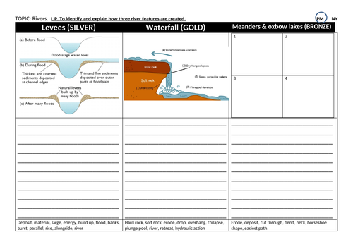
A lesson on the human impacts upon a river system.
All resources needed to deliver great learning.
Resources are structured to support the needs of all learners, from grade 9-1.
Links to mst geography GCSE specifications.
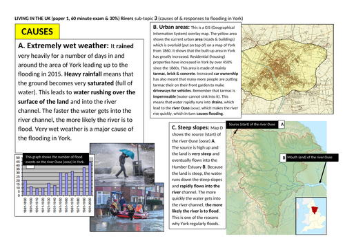
A lesson on the causes, effects & responses to flooding.
This uses the River Ouse in York, but could easily be adapted for any river.
Aimed at all year groups and all specifications.
A lesson on the human activity on rivers. Flood defence & causes.
Suitable for all age groups and specifications.
Resources really allow for independent learning and provide all of the ingredients needed for all abilities of students to access the learning.
It also has a quick GCSE style test that puts learning into context.
2 to 3 lessons worth of content.
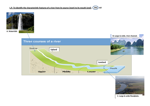
A lesson to provide learners with the opportunity to create understanding of river features.
Information sheets have been created that allow pupils to drive their own learning. The structured A3 worksheet has all of the ingredients needed for all levels of pupil to succeed and access the learning. e.g. images & glossary sections.
For any age group & specification.
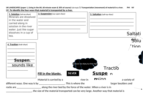
A lesson to provide learners with the opportunity to create understanding of the ways that material is transported by a river (traction, saltation, suspension & solution).
For any age group & specification.
A lesson where students learn all about the water cycle.
They create a sequenced description, which leads to the creation of a piece of poetry.
For all age groups & GCSE/KS3/KS2 specifications.
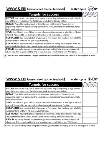
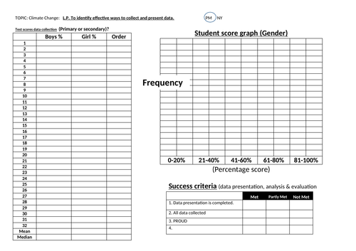
A worksheet to use with pupils post assessment.
Students firstly create a percentage from their test score.
They then collect data from their peers and fill in the table.
Once completed, they order the data and calculate the mean & median.
They then plot the data as a stack graph or double bar graph (boys & girls).
To finish, they complete the target setting sheet.
Data can be analysed once all elements have been done.
Can be used with all year groups, but works well for KS3.
A booklet that allows pupils to practice a wide and varied number of skills on school grounds.
It supports pupils in the development of key skills needed for GCSE geographical success. e.g. grid references, mapping, location, data presentation, data evaluation, questionnaires, methods and explaining.
Pupils use the booklet as a step by step guide to work through tasks, after collection of data on the school grounds.
Simple hypotheses are included along with the opportunity for conclusions.
It will require the changing of the Google earth image of the school, with your own.
This takes roughly half a term for year 7.
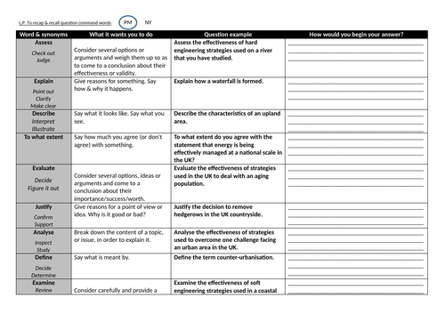
A work sheet (ideally printed in A3) that allows pupils to breakdown the correct way to answer specific command words in questions.
Designed for all levels and ages of pupils, but with a specific GCSE focus.
A 37 page revision guide for OCR GCSE Geography.
Has command word breakdown & exemplar answer sections along with higher level detail needed for longer answer success.
Lots of detail to allow pupils to access the learning needed for the more complex and longer mark questions.
Although created for OCR A & B, it can easily be amended for Edexcel & AQA.
I used it as a revision tool before the mock & final examinations.
A matrix that easily allows pupils to complete the evaluation of fieldwork/project data collection and presentation.
It outlines the hypotheses used for both human & physical fieldwork tasks and then puts all of the learning into a structured GCSE style Q & A format.
Can be used for all GCSE & A Level Geography exam boards (OCR, AQA & Edexcel)
Best printed onto A3 & back to back.
Worked brilliantly with my classes post fieldwork & as a recap lesson.
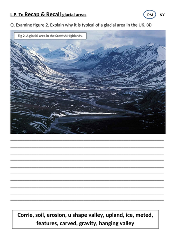
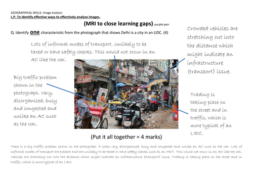
A simple task that allows pupils to analyse an image from a glacial area and compare it to a lowland area in the UK.
It provides them with a key work bank and example of what a good one should look like.
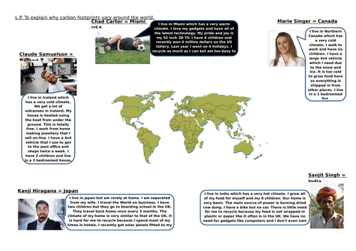
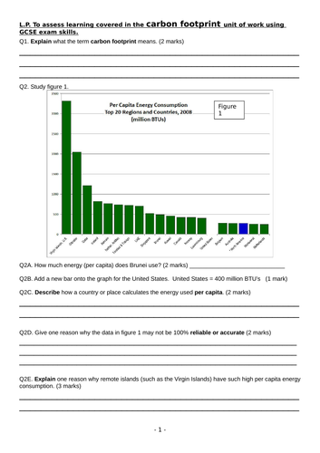
All of the resources needed to take a detailed look at why carbon footprints vary around the world related to a countries leve of development.
Linked to the geography KS 3 & 4 curriculum & covers many specifications. OCR, AQA & Edexcel
A great lesson on the effects of tourism in glacial areas.
I used this to great effect for both observation and interview lessons.
It includes all of the resources that you need and covers a huge amount of content related to AQA, OCR & edexcel 1-9 specifications.
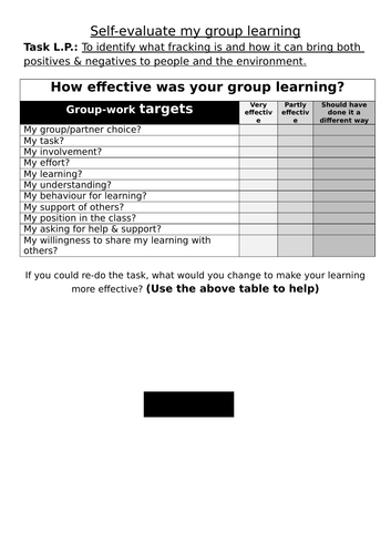
A sheet designed to be used by pupils after a piece of workwork.
It allows students to think about the processes that they undertook and how & why their practice could/should be improved in the future.
It ties well in to metacognitive thinking in that it allows learners to address the entire learning experience and not simply knowledge. This should help promote even more effective learners at a departmental & whole school level.