Lesson 10 focuses on hard and soft management strategies for rivers.
Key ideas:
Geographical skills: selecting information
Exam skills: assessment type question ‘assess’, time management, knowledge recall, information selection from unknown source, reading comprehension
Knowledge: key terms definitions, different hard and soft river management strategies
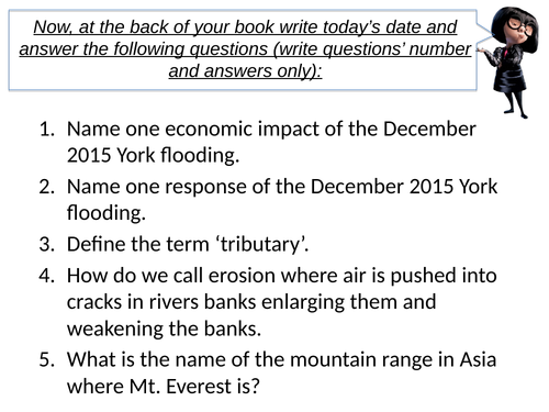
Lesson 11 focuses on the Five Year Flood plan for York following the 2015 flood.
Key ideas:
Geographical skills: selecting information, decision making
Exam skills: assessment type question ‘justify’, time management, knowledge recall, information selection from unknown source, reading comprehension, decision making
Knowledge: key terms definitions, the five-year flood plan for York
Lesson designed for KS3. All resources are in the PPT.
The lesson cover the following aspects:
importance of glaciers
results of melting of glaciers
assessment type question ‘explain’
Enjoy teaching.
Lesson designed for KS3. All resources are in the PPT.
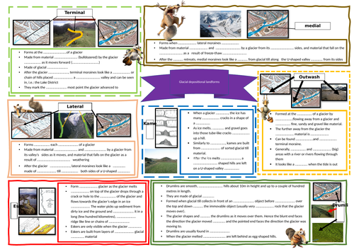
The lesson cover the following aspects:
types of moraines
drumlins
kames
eskers
erratics
assessment type question ‘label’
Enjoy teaching.
KS3 lesson. All resources are in the PPT.
The lesson covers the following aspects:
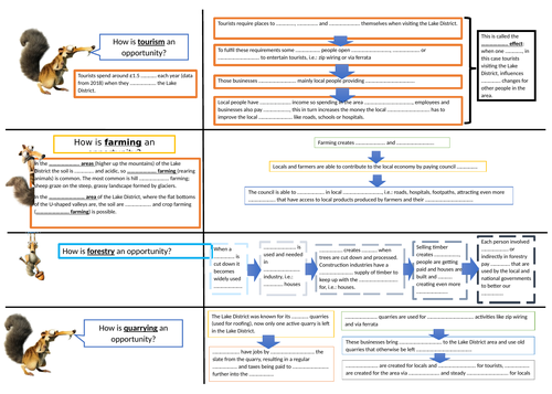
Key terminology
Economic opportunities
challenges
assessment type question ‘to what extent’
Enjoy teaching
KS3 lesson. All resources are in the PPT.
The lesson covers the following aspects:
Reasons why areas like the Lake District should be managed
Strategies used to manage the challenges in the Lake District
Evaluation of management strategies
Enjoy teaching
All resources needed are in the PPT. The lesson contains:
knowledge rich quiz for a starter
definition of coasts
types of coastal landscapes
examples of coastal cities and how coastline is used there
assessment type question
knowledge quiz at the end
Enjoy teaching
AQA GCSE Geography. All resources in the PPT + one worksheet attached.
This lesson covers the following aspects:
social, economic and environmental challenges and opportunities
GCSE type question ‘explain’ + sample answer
Enjoy teaching
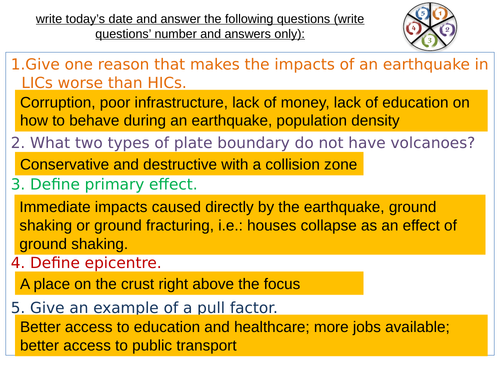
This lesson compares the responses to Japan’s earthqauke in 2011 and Haiti’s earthquake in 2010. It covers the AQA GCSE specification.
The lesson contains:
starter: knowledge quiz
task where students form their own hypothesis based on data shared with them in our previous lesson (Impacts comparison Japan and Haiti)
task where students differentiate between immediate and long term responses to Japan and Haiti’s earthqaukes
GCSE type task where students ‘examine’ their hypothesis that their formed in our first task using the information about responses
sample ‘examine’ answer
All resources needed are in the PPT.
The lesson contains:
knowledge rich starter
picture description of cave, arch, stack and stump
creation of pop up headland
explanation of the sequence of headland erosion
putting diagrams in order to consolidate the understanding of the sequence
assessment type question: explain (with answer outline)
end of lesson quiz
All resources needed are attached or included in the PPT.
The lesson contains:
knowledge rich quiz as a starter
sequence of the longshore drift
Figure based activity
assessment style question: explain
All resources are within the PPT.
The lesson contains:
knowledge rich quiz as a starter
references to specification
definitions of primary and secondary effects with examples
task where students distinguish between primary and secondary effects
definitions of immediate and long term responses with examples
task where student distinguish between immediate and long term responses
photos analysis
GCSE type question ‘explain using a picture’
All resources and answers to tasks are in the PPT.
Enjoy teaching
The lesson contains the following:
knowledge rich quiz as a starter
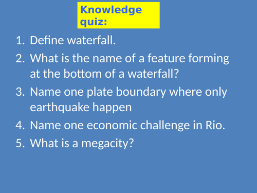
definition of meanders and ox-bow lakes
characteristics of both
sequence of formation
progress check
cross section of a meander
GCSE type question ‘explain’
end of lesson quiz
All resources are in the PPT.
Enjoy teaching
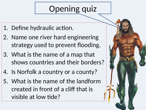
How does water flow into rivers? is a second lesson in the KS3 Geography Rivers scheme of work. Key ideas: OS map reading (geographical skills), terminology definitions (knowledge), reading comprehension (understanding), assessment focus ‘describe a sequence of…’ (exam skills).
The lesson contains:
knowledge rich starter
five main reasons for living near volcanoes
differentiation between social, economic and environmental reasons
‘explain’ GCSE type question
All resources are included in the PPT
The lesson includes:
knowledge rich quiz at the start (with answers)
definitions of hard and soft engineering, explanation of whom decision makers are and what choice do they have before taking the final decision of protecting or not
reading comprehension/information selection from unknown source based on textbook
assessment type question ‘evaluate’ with success criteria
plenary: oak academy quiz, link provided
Enjoy teaching
The lesson contains:
knowledge rich quiz as a starter
recall of stakeholder and conflict definitions
instructions for group work to study possible conflicts and finding solutions to those conflicts
Enjoy teaching
The lesson contains:
knowledge rich starter
reasons why Happisburgh needs to be protected
causes of fast erosion in Happsiburgh
opinion of different stakeholders
history of sea defenses in Happisburgh
advantages and disadvantages of proposed managed retreat
assessment type question ‘evaluate’, including an outline to structure an answer to ‘evaluate’ question
Enjoy teaching