Thank you for visiting! Here you will find a selection of printable, interactive worksheets for your classroom: Basic Geography worksheets with simple maps, ESL, Spanish, Bible, Reading Comprehension and more. I hope you find the resources useful! Reviews are welcome and very much appreciated. Thank you so much.
Thank you for visiting! Here you will find a selection of printable, interactive worksheets for your classroom: Basic Geography worksheets with simple maps, ESL, Spanish, Bible, Reading Comprehension and more. I hope you find the resources useful! Reviews are welcome and very much appreciated. Thank you so much.
Introduce your students to Argentina with this printable handout of two worksheets (plus answer key). Your students will read a brief overview of Argentina (location, capital, flag, language), write 'Buenos Aires' next to the star on the map to show the capital, color the small map and flag, and use the map and compass to answer 7 questions. Colored pencils and a pen or pencil are needed for this activity. No other prep needed. Basic Geography worksheet with a simple map to introduce Argentina and practice cardinal and ordinal directions.
For use with Interactive Notebooks: After the worksheets are completed, students can cut out the map and paste into the notebook under the topic of South America/Sub-topic: Argentina. Under the map, students can write a summary in their own words of what they now know about this country. Collect worksheets for other countries of South America to add to the notebook! Please browse this store for a selection of printable worksheets for other countries of South America (and beyond)!
Thank you so much for using my Geography worksheets in your classroom!
Introduce your learners to AUSTRIA with two worksheets (plus answer key). Your students will read a brief introduction to Austria (location, capital, flag, language), write ‘Vienna’ next to the star on the map to show the location of the capital, color the small map and flag, and use the map and compass to answer 7 questions on page 2. Colored pencils and a pen or pencil are needed for this activity. No other prep needed. Basic Geography worksheet with a simple map to introduce Austria and practice cardinal and ordinal directions.
For use with Interactive Notebooks: After the worksheets are completed, students can cut out the map and flag and paste into the notebook under the topic of Europe / Sub-topic: Austria. Under the map, students can write a summary in their own words of what they now know about Austria. Collect worksheets for other countries of Europe to add to the notebook! All available in this store! Please browse this store for a selection of printable Geography worksheets for other countries of Europe (and beyond!).
Thank you for using my Geography worksheets in your classroom! I hope you find them useful. Reviews are welcome and very much appreciated!
German
Introduce your learners to Finland with two worksheets (plus answer key). Your students will read a brief introduction to Finland (location, capital, flag, language), write 'Helsinki' next to the star on the map to show the location of the capital, color the map, and use the map and compass to answer 6 questions on page 2. Colored pencils and a pen or pencil are needed for this activity. No other prep needed. Basic Geography worksheet with a simple map to introduce Finland and practice cardinal and ordinal directions.
For use with Interactive Notebooks: After completing the worksheets, students can cut out the map and flag and paste it into the notebook under the topic of Europe / Sub-Topic: Finland. Under the map and flag, students can write a summary in their own words of what they now know about Finland. Collect worksheets for other countries of Europe to add to the notebook! Please browse this store for worksheets for other countries of Europe (and beyond!)
Thank you so much for using my worksheets in your classroom!
Introduce your students to Hungary with two worksheets (plus answer key). Your students will read a brief introduction to Hungary (location, capital, flag, language), write 'Budapest' next to the star on the map to show the location of the capital, color the small map and flag, and use the map and compass to answer 9 questions on page 2. Colored pencils and a pen or pencil are needed for this activity. No other prep needed. Basic Geography worksheet with a simple map to introduce Hungary and practice cardinal and ordinal directions.
For use with Interactive Notebooks: After completing the worksheets, students can cut out the map and flag and paste it into the notebook under the topic of Europe / Sub-Topic: Hungary. Under the map and flag, students can write a summary in their own words of what they now know about this country. Collect worksheets for other countries of Europe to add to the notebook! Please browse this store for a selection of worksheets for other countries of Europe (and beyond!).
Thank you so much for using my Geography worksheets in your classroom! Reviews are welcome and very much appreciated.
Introduce your students to Czech Republic with this printable handout of two worksheets (plus answer key). Your students will read a brief overview of Czech Republic (location, capital, flag, language), write 'Prague' next to the star on the map to show the capital, color the small flag and map, and use the map and compass to answer 7 questions. Colored pencils and a pen or pencil are needed for this activity. No other prep needed.
For use with Interactive Notebooks: After completing the handout, students can cut out the map and flag and paste it into the notebook under the topic of Europe / Sub-Topic: Czech Republic. Under the map and flag, students can write a summary in their own words of what they now know about Czech Republic. Collect handouts for all countries of Europe to add to notebook.
Thank you so much for using my Geography worksheets in your classroom! Reviews are welcome and very much appreciated. Please follow my store for more Geography worksheets.
Thank you again!
cardinal, ordinal, directions, Czechoslovakia, north, south, east, west.
Introduce your students to the country of Paraguay in South America with this printable handout of two worksheets (plus answer key). Your students will read a brief introduction to Paraguay (location, capital, flag, language), write 'Asunción' next to the star on the map to show the location of the capital, color the map and flag, and use the map and compass to answer 6 questions on page 2. Colored pencils and a pen or pencil are needed for this activity. No other prep needed. Basic Geography worksheet with a simple map to introduce the country of Paraguay and practice cardinal and ordinal directions.
For use with Interactive Notebooks: After the worksheets for Paraguay are completed, students can cut out the map and flag and paste into the notebook under the topic of South America/Sub-Topic: Paraguay. Under the map, students can write a summary in their own words of what they now know about this country. Please browse this store for a selection of worksheets for other countries of South America (and beyond!)
Thank you so much for using my Geography worksheets in your classroom! Reviews are welcome and very much appreciated!
Introduce your learners to South America one country at a time with printable handouts for each country. For each country of South America, your students will read a brief overview of the country (location, capital, flag, language), write the capital next to the star on the map, color the small map and flag, and use the map and compass to answer questions and identify the locations of surrounding countries. Printable handouts for countries of South America include: Argentina, Bolivia, Brazil, Chile, Colombia, Ecuador, Guyana, Paraguay, Peru, Suriname, Uruguay, Venezuela, and French Guiana. Colored pencils and a pen or pencil are needed for this activity. Cover one country a day or one country a week. Use the printable handouts for South America (South America List of Countries and Capitals, Fill in the Blanks, Word Search) after individual countries are completed. For use with Interactive Notebooks: After your student completes the handout for a country, cut out the map and flag and paste into the notebook under the topic of South America / Sub-Topic (country). Under the map and flag, the student will write a summary in their own words about what they now know about that country.
Thank you for using my Geography worksheets in your classroom!
Introduce your students to the countries and capitals of South America! This printable handout of 4 pages includes a list of the 12 countries and capitals and the 3 dependent territories and capitals of South America. Your students will read a brief introduction to South America, write the capital of each country on the map, color the map, and answer the questions that follow. Answer key included.
For worksheets for each country of South America, please check out this discounted bundle: https://www.tes.com/teaching-resource/resource-12525113
Thank you so much for using my Geography worksheets in your classroom! I hope you find them useful. Reviews are welcome and very much appreciated!
Introduce your students to Uruguay with this printable handout of two worksheets (plus answer key). Your students will read a brief overview of Uruguay (location, capital, language, flag), write 'Montevideo' next to the star on the map to show the capital, color the small map and flag, and use the map and compass to answer 7 questions. Basic Geography worksheet with a simple map to introduce Uruguay and practice cardinal and ordinal directions.
For use with Interactive Notebooks: After the handout is completed, students can cut out the map and flag and paste into the notebook under the topic of South America/Sub-Topic: Uruguay. Under the map, your students will write a summary in their own words of what they now know about this country. Collect handouts for other countries of South America to add to the notebook! Please browse this store for a selection of printable Geography worksheets for other countries of South America (and beyond!).
Thank you so much for using my Geography worksheets in your classroom! I hope you find them useful. Reviews are welcome and very much appreciated. Please follow this store for more printables.
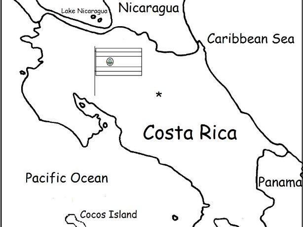
Introduce your students to Costa Rica with two worksheets (plus answer key). Your students will read a brief introduction to Costa Rica (location, capital, language, flag), write 'San José' next to the star on the map to show the location of the capital, color the small flag and map, and use the map and compass to answer 6 questions on page 2. Colored pencils and a pen or pencil are needed for this activity. No other prep needed. Basic Geography worksheet with a simple map to introduce Costa Rica and practice cardinal and ordinal directions.
For use with Interactive Notebooks: After the worksheets are completed, students can cut out the map and flag and paste into the notebook under the topic of Central America (or Spanish-Speaking Countries) /Sub-Topic: Costa Rica. Under the map and flag, students can write a summary in their own words of what they now know about this country. Collect worksheets for other countries of Central America (or Spanish-Speaking Countries) to add to the notebook! Worksheets for all countries available in this store! Please browse this store for a selection of printable Geography worksheets for other countries of Central America and beyond!
Thank you so much for using my Geography worksheets in your classroom! I hope you find them useful. Reviews are welcome and very much appreciated! Please browse this store for a selection of worksheets to introduce your learners to the countries of the world!
Introduce your students to French Guiana with this printable handout of 2 worksheets (plus answer key). Your students will read a brief overview of French Guiana (location, capital, language, flag), write 'Cayenne' next to the star on the map to show the capital, color a small map and flag, and use the map and compass to answer 6 questions. Basic Geography worksheet with a simple map to introduce French Guiana and practice cardinal and ordinal directions.
For use with Interactive Notebooks: After the handout is completed, students can cut out the map and flag and paste into the notebook under the topic South America/Sub-Topic: French Guiana. Under the map, your students can write a summary in their own words of what they now know about French Guiana. Collect handouts for other countries of South America to add to the notebook. Please browse this store for a selection of printable handouts of other countries of South America (and beyond!).
Thank you so much for using my Geography worksheets in your classroom! Reviews are welcome and very much appreciated.
This printable handout includes a map of Ecuador and surrounding countries. Directions: Write ‘Quito’ next to the star on the map to show the capital of Ecuador. Fill in the blanks on the map for each country (Ecuador, Peru, Colombia, Pacific Ocean). Color the map. Then using your map and compass, answer 4 questions on page 2.
Crayons or colored pencils are needed for this activity. No other prep needed.
Introduce your students to Guyana with this printable handout of two worksheets (plus answer key). Your students will read a brief overview of Guyana (location, capital, flag, language), write 'Georgetown' next to the star on the map to show the capital, color the small map and flag, and use the map and compass to answer 6 questions. Colored pencils and a pen or pencil are needed for this activity. No other prep needed. Basic Geography worksheet with a simple map to introduce Guyana and practice cardinal and ordinal directions.
For use with Interactive Notebooks: After the handout is completed, students can cut out the map and paste into the notebook under the topic of South America/Sub-Topic: Guyana. Under the map, your students will write a summary in their own words of what they now know about this country. Collect handouts for other countries of South America to add to the notebook! Please browse this store for a selection of printable handouts for other countries of South America (and beyond!).
This activity is usually done in class but can also be assigned as homework.
Thank you so much for using my Geography worksheets in your classroom!
Introduce your students to North Korea with this printable handout of 2 worksheets (plus answer key). Your students will read a brief introduction to North Korea (location, capital, flag, language), write 'Pyongyang’ next to the star on the map to show the location of the capital, write DMZ on the border of North and South Korea to show the location of the Korean Demilitarized Zone, color the small flag and map, and use the map and compass to answer 9 questions on page 2. Colored pencils and a pen or pencil are needed for this activity. No other prep needed. Basic Geography worksheet with a simple map to introduce North Korea.
For use with Interactive Notebooks: After the worksheets are completed, students can cut out the map and flag and paste into the notebook under the topic of Asia/Sub-Topic: North Korea. Under the map, students can write a summary in their own words of what they now know about North Korea. Collect handouts for other countries of Asia to add to the notebook! Please browse this store for a selection of printable handouts for other countries of Asia (and beyond!).
Thank you so much for using my Geography worksheets in your classroom! I hope you find them useful. Reviews are welcome and very much appreciated! Please browse this store for worksheets with simple maps to introduce your learners to the countries of the world!
Teach your students about KOREA with this printable handout of two worksheets (plus answer key). Your students will read a brief overview of Korea (located in East Asia, consists of North and South Korea, bordered by China, Russia, and Japan and surrounded by the Sea of Japan, Yellow Sea, Korea Bay, and Korea Strait). Your students will color a small map of Korea and surrounding area and then use the map and compass to answer five questions.
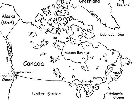
Introduce your students to CANADA with this printable handout of two worksheets (plus answer key). Your students will read a brief overview of Canada (location, capital, flag, language), write ‘Ottawa’ next to the star on the map to show the capital, color the small flag and map, and use the map and compass to answer 9 questions. Colored pencils or crayons and a pen or pencil are needed for this activity. No other prep needed.
For use with Interactive Notebooks: After the handout is completed, students can cut out the map and flag and paste into the notebook under the topic of North America / Sub-Topic: Canada. Under the map and flag, students will write a summary in their own words of what they now know about Canada.
Thank you for using my Geography worksheets in your classroom!
Included on this map: Alaska, Greenland, Iceland, United States, Arctic Ocean, Pacific, Atlantic Ocean, Vancouver, Montreal, Toronto. Cardinal, ordinal directions.
Introduce your learners to the US state of TEXAS with two worksheets (plus answer key). Your students will read a brief introduction to Texas (location, capital, flag, state bird and state flower), write ‘Austin’ next to the star on the map to show the location of the capital, color the small map, state bird and state flower, and use the map and compass to answer 7 questions on page 2. Colored pencils and a pen or pencil are needed for this activity. No other prep needed. Basic Geography worksheet with a simple map to introduce Texas and practice cardinal and ordinal directions.
For use with Interactive Notebooks: After the worksheets are completed, students can cut out the map, flag, state bird and state flower, and paste into the notebook under the topic of United States/Sub-Topic: Texas. Under the map, students can write a summary of what they now know about this state. Collect worksheets for all states to add to the notebook! Please browse this store for worksheets for other states of the USA (and beyond!)
Thank you so much for using my Geography worksheets in your classroom! I hope you find them useful. Reviews are welcome and very much appreciated.
State bird: Northern Mockingbird
State flower: Bluebonnet
Introduce your students to EQUATORIAL GUINEA with two worksheets (plus answer key). Your students will read a brief introduction to Equatorial Guinea (location, capital, flag, language), write ‘Malabo’ next to the star on the map to show the location of the capital, trace the dotted line to show the equator, color the small flag and map, and then use the map and compass to answer 8 questions on page 2. Pen or pencil and colored pencils needed for this activity. No other prep needed. Basic Geography worksheet with a simple map to introduce Equatorial Guinea and practice cardinal and ordinal directions.
For use with Interactive Notebooks: After the worksheets are completed, students can cut out the map and flag and paste into the notebook under the topic of Topic: Africa / Sub-Topic: Equatorial Guinea. (or Topic: Spanish-Speaking Countries / Sub-Topic: Equatorial Guinea). Under the map, your students can write a summary in their own words of what they now know about this country. Collect worksheets for other countries of Africa or Spanish-speaking countries to add to the notebook! Please browse this store for worksheets for other countries!
Thank you so much for using my Geography worksheets in your classroom! Reviews are welcome and very much appreciated.
Africa, Spanish, Gulf of Guinea, cardinal, ordinal directions.
Introduce your students to Puerto Rico with this printable handout of two worksheets (plus answer key). Your students will read a brief introduction to Puerto Rico (location, capital, flag, language), write ‘San Juan’ next to the star on the map to show the location of the capital, color the small map and flag, and use the map and compass to answer 6 questions on page 2. Colored pencils and a pen or pencil are needed for this activity. No other prep needed.
For use with Interactive Notebooks: After the worksheets are completed, students can cut out the map and flag of Puerto Rico and paste into the notebook. Under the map and flag, students can write a summary in their own words of what they now know about Puerto Rico. Collect worksheets for other countries to add to the notebook! Please browse this store for a selection of worksheets for Caribbean Islands, Spanish-speaking countries, and beyond!
Thank you so much for using my Geography worksheets in your classroom! I hope you find them useful. Reviews are welcome and very much appreciated!
Included on map of Puerto Rico and surrounding: Atlantic Ocean, Caribbean Sea, Mona, Culebra, Viequez, Desecheo, Florida, Dominican Republic, Haiti, Cuba. Cardinal, ordinal directions.
Introduce your students to the state of Nevada with this printable handout of two worksheets (plus answer key). Your students will read a brief overview of Nevada (location, capital, flag, state bird and state flower), write ‘Carson City’ next to the star on the map to show the capital, color the small map, and use the map and compass to answer 7 questions on page 2. Colored pencils or crayons and a pen or pencil are needed for this activity. No other prep needed.
For use with Interactive Notebooks: After the handout is completed, students can cut out the map and paste into the notebook under the topic of United States / Sub-Topic: Nevada. (students can also cut and paste the state flag, bird, flower to include on page). Under the map, students will write a summary in their own words of what they now know about the state of Nevada. Collect handouts for all states to add to notebook. Other handouts available for ARKANSAS, KENTUCKY, MISSOURI, NEW YORK, TEXAS. More to come soon! Please Follow This Store for more worksheets.
Thank you so much for using my Geography worksheets in your classroom! I hope you find them useful. Reviews are welcome and very much appreciated.