Thank you for visiting! Here you will find a selection of printable, interactive worksheets for your classroom: Basic Geography worksheets with simple maps, ESL, Spanish, Bible, Reading Comprehension and more. I hope you find the resources useful! Reviews are welcome and very much appreciated. Thank you so much.
Thank you for visiting! Here you will find a selection of printable, interactive worksheets for your classroom: Basic Geography worksheets with simple maps, ESL, Spanish, Bible, Reading Comprehension and more. I hope you find the resources useful! Reviews are welcome and very much appreciated. Thank you so much.
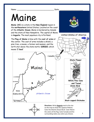
Introduce your learners to the state of MAINE in the USA with this printable handout of two worksheets (plus answer key). Your students will read a brief overview of Maine (location, capital, flag, state bird, state flower), write ‘Augusta’ next to the star on the map to show the location of the capital, color the small map, and use the map and compass to answer 10 true/false questions on page 2. Colored pencils and a pen or pencil are needed for this activity. No other prep needed. Basic Geography worksheet with a simple map to introduce the state of Maine and practice cardinal and ordinal directions.
For use with Interactive Notebooks: After the worksheets are completed, students can cut out the map and flag of Maine and paste into the notebook under the topic of United States/Sub-Topic: Maine. Under the map, students can write a summary in their own words of what they now know about this state. Collect worksheets for other states of the United States to add to the notebook! Please browse this store for a selection of worksheets for other states of the USA (and beyond!)
Thank you so much for using my worksheets in your classroom! Reviews are welcome and very much appreciated.
Included: Canada, New Hampshire, Portland, Dirigo, state motto, Black-capped chickadee, White pine cone and tassel
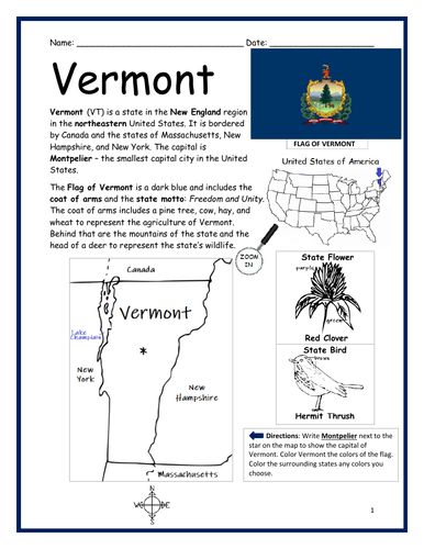
Introduce your learners to the state of VERMONT in the USA with this printable handout of two worksheets (plus answer key). Your students will read a brief overview of Vermont (location, capital, flag, state bird, state flower), write ‘Montpelier’ next to the star on the map to show the location of the capital, color the small map, and use the map and compass to answer 10 true/false questions on page 2. Colored pencils and a pen or pencil are needed for this activity. No other prep needed. Basic Geography worksheet with a simple map to introduce the state of Vermont and practice cardinal and ordinal directions.
For use with Interactive Notebooks: After the worksheets are completed, students can cut out the map and flag of Vermont and paste into the notebook under the topic of United States/Sub-Topic: Vermont. Under the map, students can write a summary in their own words of what they now know about this state. Collect worksheets for other states of the United States to add to the notebook! Please browse this store for a selection of worksheets for other states of the USA (and beyond!)
Thank you so much for using my worksheets in your classroom. Reviews are welcome and very much appreciated!
Included: Canada, New Hampshire, New York, Massachusetts, state motto Freedom and Unity, Hermit Thrush, Red Clover
Introduce your learners to the US state of TENNESSEE with this printable handout of two worksheets (plus answer key). Your students will read a brief overview of Tennessee (location, capital, flag, state bird, state flower), write ‘Nashville’ next to the star on the map to show the location of the capital, color the small map, state bird and flower, and use the map and compass to answer 10 true/false questions on page 2. Colored pencils and a pen or pencil are needed for this activity. No other prep needed. Basic Geography worksheet with a simple map to introduce the state of Tennessee and practice cardinal and ordinal directions.
For use with Interactive Notebooks: After the worksheets are completed, students can cut out the map, flag, state bird and flower of Tennessee and paste into the notebook under the topic of United States/Sub-Topic: Tennessee. Under the map, students can write a summary in their own words of what they now know about this state. Collect worksheets for other states of the United States to add to the notebook! Please browse this store for a selection of worksheets for other states of the USA (and beyond!).
Thank you so much for using my worksheets in your classroom. Reviews are welcome and very much appreciated!
Included: Memphis, Cumberland River, Mississippi River, Appalachian Mountains, Kentucky, Virginia, North Carolina, Georgia, Alabama, Mississippi, Arkansas, Missouri, Mockingbird, Iris, three geographic regions.
Introduce your learners to the state of North Dakota in the USA with this printable handout of two worksheets (plus answer key). Your students will read a brief overview of North Dakota (location, capital, flag, state bird, state flower), write ‘Bismarck’ next to the star on the map to show the location of the capital, trace the lines of the Missouri River and Red River BLUE, color the small map, state bird and flower, and use the map and compass to answer 10 true/false questions on page 2. Colored pencils and a pen or pencil are needed for this activity. No other prep needed. Basic Geography worksheet with a simple map to introduce the state of North Dakota and practice cardinal and ordinal directions.
For use with Interactive Notebooks: After the worksheets are completed, students can cut out the map, flag, state bird and flower of North Dakota and paste into the notebook under the topic of United States/Sub-Topic: North Dakota. Under the map, students can write a summary in their own words of what they now know about this state. Collect worksheets for other states of the United States to add to the notebook! Please browse this store for a selection of worksheets for other states of the USA (and beyond!).
Thank you so much for using my worksheets in your classroom! Reviews are welcome and very much appreciated.
Included: Fargo, Dakota Native American Tribe, State Motto E Pluribus Unum, Western Meadowlark, Wild Prairie Rose, Lake Sakakawea, Minnesota, South Dakota, Montana, Canada, Great Plains Region, Dakota Territory.
Introduce your learners to the state of OKLAHOMA in the USA with this printable handout of two worksheets (plus answer key). Your students will read a brief overview of Oklahoma (location, capital, flag, state bird, state flower), write ‘Oklahoma City’ next to the star on the map to show the location of the capital, color the small map, and use the map and compass to answer 10 true/false questions on page 2. Colored pencils and a pen or pencil are needed for this activity. No other prep needed. Basic Geography worksheet with a simple map to introduce the state of Oklahoma and practice cardinal and ordinal directions.
For use with Interactive Notebooks: After the worksheets are completed, students can cut out the map and flag of Oklahoma and paste into the notebook under the topic of United States/Sub-Topic: Oklahoma. Under the map, students can write a summary in their own words of what they now know about this state. Collect worksheets for other states of the United States to add to the notebook! Please browse this store for a selection of worksheets for other states of the USA (and beyond!).
Thank you so much for using my worksheets in your classroom. Reviews are welcome and very much appreciated!
Included: Texas, Kansas, Missouri, Arkansas, state motto, state bird, state flower, 46th state, Scissor-Tailed flycatcher, Oklahoma Rosa.
Introduce your learners to the state of South Dakota in the USA with this printable handout of two worksheets (plus answer key). Your students will read a brief overview of South Dakota (location, capital, flag, state bird, state flower), write ‘Pierre’ next to the star on the map to show the location of the capital, trace the lines of the Missouri River and Red River BLUE, color the small map, state bird and flower, and use the map and compass to answer 10 true/false questions on page 2. Colored pencils and a pen or pencil are needed for this activity. No other prep needed. Basic Geography worksheet with a simple map to introduce the state of South Dakota and practice cardinal and ordinal directions.
For use with Interactive Notebooks: After the worksheets are completed, students can cut out the map, flag, state bird and flower and paste into the notebook under the topic of United States/Sub-Topic: South Dakota. Under the map, students can write a summary in their own words of what they now know about this state. Collect worksheets for other states of the United States to add to the notebook! Please browse this store for a selection of worksheets for other states of the USA (and beyond!).
Thank you so much for using my worksheets in your classroom! Reviews are welcome and very much appreciated.
Included: Mount Rushmore, Ring-necked Pheasant, American Pasque, Sioux Falls, 1889, East River, West River, Black Hills, Great Plains region, North Dakota, Minnesota, Iowa, Nebraska, Wyoming, Montana, mid-west region.
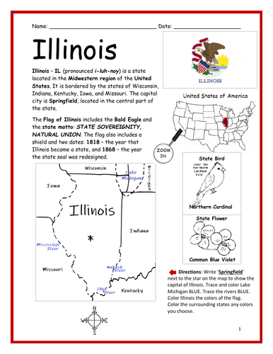
Introduce your learners to the state of Illinois in the USA with this printable handout of two worksheets (plus answer key). Your students will read a brief overview of Illinois (location, capital, flag, state bird, state flower), write ‘Springfield’ next to the star on the map to show the location of the capital, trace the lines of Lake Michigan, Mississippi River, Ohio River, and Wabash River BLUE, color the small map, state bird and flower, and use the map and compass to answer 10 true/false questions on page 2. Colored pencils and a pen or pencil are needed for this activity. No other prep needed. Basic Geography worksheet with a simple map to introduce the state of Illinois and practice cardinal and ordinal directions.
For use with Interactive Notebooks: After the worksheets are completed, students can cut out the map, flag, state bird and flower and paste into the notebook under the topic of United States/Sub-Topic: Illinois. Under the map, students can write a summary in their own words of what they now know about this state. Collect worksheets for other states of the United States to add to the notebook! Please browse this store for a selection of worksheets for other states of the USA (and beyond!).
Thank you so much for using my worksheets in your classroom! Reviews are welcome and very much appreciated. Please click here to FOLLOW THIS STORE for alerts and free printables!
Included: Midwest region, Wisconsin, Michigan, Indiana, Kentucky, Iowa, Missouri, Northern Cardinal, Common Blue Violet, 1818, 1868, state motto: STATE SOVEREIGNITY, NATURAL UNION. Bald eagle.
Introduce your learners to the US state of Iowa with this printable handout of two worksheets (plus answer key). Your students will read a brief overview of Iowa (location, capital, flag, state bird, state flower), write ‘Des Moines’ next to the star on the map to show the location of the capital, trace the lines of the Des Moines River, Mississippi River and Missouri River, color the small map, state bird and flower, and use the map and compass to answer 10 true/false questions on page 2. Colored pencils and a pen or pencil are needed for this activity. No other prep needed. Basic Geography worksheet with a simple map to introduce the state of Iowa and practice cardinal and ordinal directions.
For use with Interactive Notebooks: After the worksheets are completed, students can cut out the map, flag, state bird and flower and paste into the notebook under the topic of United States/Sub-Topic: Iowa. Under the map, students can write a summary in their own words of what they now know about this state. Collect worksheets for other states of the United States to add to the notebook! Please browse this store for a selection of worksheets for other states of the USA (and beyond!)
Thank you so much for using my worksheets in your classroom! Reviews are welcome and very much appreciated.
Included: midwestern region, Des Moines pronunciation, American Goldfinch, Prairie Rose, Ioway, Bald Eagle, state motto: Our Liberties we prize and our rights we will remain. Wisconsin, Illinois, Missouri, Nebraska, South Dakota, Minnesota.
Introduce your learners to the US state of Louisiana with this printable handout of two worksheets (plus answer key). Your students will read a brief overview of Louisiana (location, capital, flag, state bird, state flower), write ‘Baton Rouge’ next to the star on the map to show the location of the capital, trace the line of the Mississippi River BLUE, color the small map, state bird and flower, and use the map and compass to answer 10 true/false questions on page 2. Colored pencils and a pen or pencil are needed for this activity. No other prep needed. Basic Geography worksheet with a simple map to introduce the state of Louisiana and practice cardinal and ordinal directions.
For use with Interactive Notebooks: After the worksheets are completed, students can cut out the map, flag, state bird and flower and paste into the notebook under the topic of United States/Sub-Topic: Louisiana. Under the map, students can write a summary in their own words of what they now know about this state. Collect worksheets for other states of the United States to add to the notebook! Please browse this store for a selection of worksheets for other states of the USA (and beyond!)
Thank you so much for using my worksheets in your classroom! Reviews are welcome and very much appreciated.
Included: southeast region, Texas, Arkansas, Mississippi, Gulf of Mexico, Mississippi River, New Orleans, Mardi Gras, State motto Union, Justice, Confidence. Brown Pelican, Magnolia
Introduce your students to Brazil in South America with this black & white printable handout of two worksheets (plus answer key). Your students will read a brief overview of Brazil (location, capital, flag, language), write ‘Brasília’ next to the star on the map to show the location of the capital, color the map and flag, and use the map and compass to answer 9 questions on page 2. Colored pencils and a pen or pencil are needed for this activity. No other prep needed. Basic Geography worksheet with a simple map to introduce the country of Brazil and practice cardinal and ordinal directions.
This worksheet can be printed in black and white. Students will color the color the map and flag.
Thank you so much for using my Geography worksheets in your classroom! Reviews are welcome and very much appreciated!
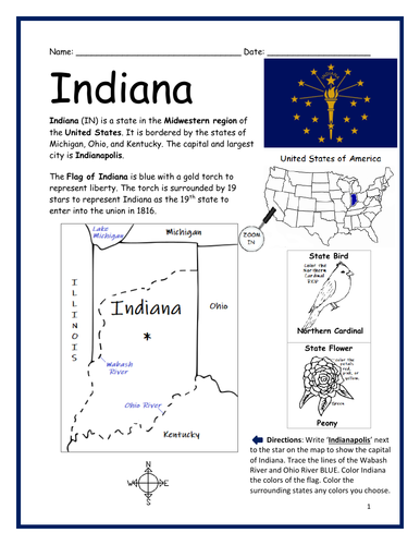
Introduce your learners to the US state of Indiana with this printable handout of two worksheets (plus answer key). Your students will read a brief overview of Indiana (location, capital, flag, state bird, state flower), write ‘Indianapolis’ next to the star on the map to show the location of the capital, trace the lines of Wabash River and Ohio River, color the small map, state bird and flower, and use the map and compass to answer 10 true/false questions on page 2. Colored pencils and a pen or pencil are needed for this activity. No other prep needed. Basic Geography worksheet with a simple map to introduce the state of Indiana and practice cardinal and ordinal directions.
For use with Interactive Notebooks: After the worksheets are completed, students can cut out the map, flag, state bird and flower and paste into the notebook under the topic of United States/Sub-Topic: Indiana. Under the map, students can write a summary in their own words of what they now know about this state. Collect worksheets for other states of the United States to add to the notebook! Please browse this store for a selection of worksheets for other states of the USA and countries around the world!
Thank you so much for using my worksheets in your classroom! Reviews are welcome and very much appreciated.
Included: midwestern region, Michigan, Lake Michigan, Ohio, Kentucky, Illinois, Peony, Northern Cardinal, torch, 19th state.
Introduce your learners to the state of Michigan in the USA with this printable handout of two worksheets (plus answer key). Your students will read a brief overview of Michigan (location, capital, flag, state bird, state flower, state motto), write ‘Lansing’ next to the star on the map to show the location of the capital, color the small map, state bird and flower, and use the map and compass to answer 10 true/false questions on page 2. Colored pencils and a pen or pencil are needed for this activity. No other prep needed. Basic Geography worksheet with a simple map to introduce the state of Michigan and practice cardinal and ordinal directions. Map includes the Upper and Lower Peninsulas, Detroit, Straits of Mackinac, Lake St. Clair, Canada, surrounding states of Ohio, Indiana, Illinois and Wisconsin, and 4/5 Great Lakes that border Michigan: Lake Superior, Lake Michigan, Lake Huron and Lake Erie.
For use with Interactive Notebooks: After the worksheets are completed, students can cut out the map, flag, state bird and flower and paste into the notebook under the topic of United States/Sub-Topic: Michigan. Under the map, students can write a summary in their own words of what they now know about this state. Collect worksheets for other states of the United States to add to the notebook! Please browse this store for a selection of worksheets for other states of the USA and countries around the world!
Thank you so much for using my worksheets in your classroom! Reviews are welcome and very much appreciated.
state motto, American Robin Apple Blossom
Introduce your learners to the state of Minnesota in the USA with this printable handout of two worksheets (plus answer key). Your students will read a brief introduction to Minnesota (location, capital, flag, state bird, state flower, state motto), write ‘Saint Paul’ next to the star on the map to show the location of the capital, trace the lines of the Mississippi River and St. Croix River BLUE, color the small map, state bird and flower, and use the map and compass to answer 10 true/false questions on page 2. Colored pencils and a pen or pencil are needed for this activity. No other prep needed. Basic Geography worksheet with a simple map to introduce the state of Minnesota and practice cardinal and ordinal directions.
For use with Interactive Notebooks: After the worksheets are completed, students can cut out the map, flag, state bird and flower and paste into the notebook under the topic of United States/Sub-Topic: Minnesota. Under the map, students can write a summary in their own words of what they now know about this state. Collect worksheets for other states of the United States to add to the notebook! All available in this store. Please browse this store for a selection of worksheets for other states of the USA! (and beyond!)
Thank you so much for using my worksheets in your classroom! I hope you find them useful. Reviews are welcome and very much appreciated!
Midwestern region, Great Lakes Region, Lake Superior, Wisconsin, Michigan, Wisconsin, Iowa, North Dakota, South Dakota, Canada, Twin Cities, Minneapolis, Twin Cities
Introduce your students to Bolivia in South America with this black & white printable handout of two worksheets (plus answer key). Your students will read a brief overview of Bolivia (location, capital, flag, language), write ‘Sucre’ next to the star on the map to show the location of the capital, color the map and flag, and use the map and compass to answer 7 questions on page 2. Colored pencils and a pen or pencil are needed for this activity. No other prep needed. Basic Geography worksheet with a simple map to introduce the country of Bolivia and practice cardinal and ordinal directions.
Please note this worksheet is in black and white so students can color the flag in addition to the map.
Thank you so much for using my Geography worksheets in your classroom! Reviews are welcome and very much appreciated!
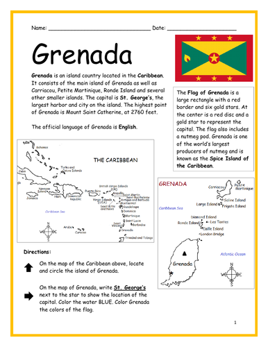
Introduce your learners to the Caribbean island country of Grenada with two printable worksheets (plus answer key). Simple map activity and reading comprehension questions. Your students will read a brief introduction to Grenada (location, capital, flag, language), locate and circle Grenada on the map of the Caribbean (map 1), write ‘St. George’s’ next to the star on the map of Grenada (map 2) to show the location of the capital, color the map, and use the reading passage, maps and compass to answer 10 true/false questions on page 2. Colored pencils and a pen or pencil are needed for this activity. No other prep needed. Basic Geography worksheet with a simple map to introduce Dominica and practice cardinal and ordinal directions. Print and Go!
For use with Interactive Notebooks: After the worksheets are completed, students can cut out the map and flag and paste into the notebook under the topic of (example) The Caribbean / Sub-topic: Grenada. Under the map, your students can write a summary in their own words of what they now know about this country. Collect worksheets of other countries of the Caribbean (or North America) to add to the notebook! All available in this store!
Thank you so much for using my Geography worksheets in your classroom! I hope you find them useful. Reviews are welcome and very much appreciated! Please browse this store for more worksheets to introduce your learners to the countries of the world!
Islands included on map of Grenada: Carriacou, Petite Martinique, Saline Island, Frigate, Large, Diamond, Ronde, Les Tantes, Caille, London Bridge
SPED, Resource Room Teacher, Primary school, elementary.
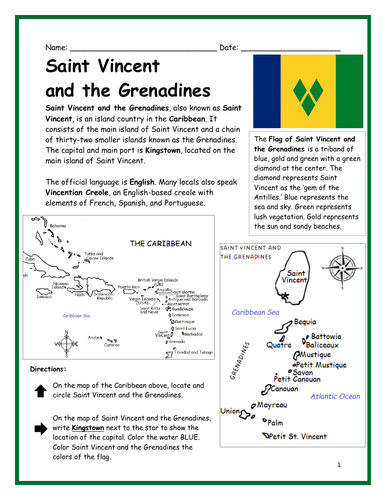
Introduce your learners to Saint Vincent and the Grenadines with two printable worksheets (plus answer key). Simple map activity and reading comprehension questions. Your students will read a brief introduction to Saint Vincent and the Grenadines (location, capital, flag, language), locate and circle Saint Vincent on the map of the Caribbean (map 1), write ‘Kingstown’ next to the star on the map of Saint Vincent (map 2) to show the location of the capital, color the map, and use the reading passage, maps and compass to answer 10 true/false questions on page 2. Colored pencils and a pen or pencil are needed for this activity. No other prep needed. Basic Geography worksheet with a simple map to introduce Saint Vincent and the Grenadines and practice cardinal and ordinal directions. Print and Go!
For use with Interactive Notebooks: After the worksheets are completed, students can cut out the map and flag and paste into the notebook under the topic of (example) The Caribbean / Sub-topic: Saint Vincent and the Grenadines. Under the map, your students can write a summary in their own words of what they now know about this country. Collect worksheets of other countries of the Caribbean (or North America) to add to the notebook! All available in this store!
Thank you so much for using my Geography worksheets in your classroom. I hope you find them useful. Reviews are welcome and very much appreciated!
Introduce your students to Peru with this printable handout of two worksheets (plus answer key). Your students will read a brief overview of Peru (location, capital, flag, language), write 'Lima' next to the star on the map to show the capital, color a small map and flag, and use the map and compass to answer 7 questions. Basic Geography worksheet with a simple map to introduce Peru and practice cardinal and ordinal directions.
For use with Interactive Notebooks: After the handouts are completed, students can cut out the map and flag of Peru and paste into the notebook under the topic of South America/Sub-Topic: Peru. Under the map, your students will write a summary in their own words of what they now know about this country.
Collect handouts for other countries of South America to add to the notebook. Please browse this store for a selection of printable handouts for other countries of South America (and beyond!).
Thank you so much for using my Geography worksheets in your classroom!
Introduce your learners to Ecuador with this printable handout of two worksheets (plus answer key). Instant download. No prep. Print and go!
This worksheet includes a basic fact sheet about Ecuador with info such as location, climate, currency, language, and national motto, followed by a Cloze Activity / Fill-in-the-blank worksheet.
Thank you for using my worksheets in your classroom! I hope you find them useful. Reviews are welcome and very much appreciated! Please browse this store for more worksheets to introduce your learners to the countries of the world!
Do your students know all 51 countries of Europe? With this printable activity, your students will fill in the blank letters for each country of Europe! One printable worksheet plus answer key that includes the list of countries in alphabetical order. Print and go!
List of countries included: Albania, Andorra, Armenia, Austria, Azerbaijan, Belarus, Belgium, Bosnia and Herzegovina, Bulgaria, Croatia, Cyprus, Czech Republic, Denmark, Estonia, Finland, France, Georgia, Germany, Greece, Hungary, Iceland, Ireland, Italy, Kazakhstan, Kosovo, Latvia, Lithuania, Luxembourg, Macedonia, Malta, Moldova, Monaco, Montenegro, Netherlands, Norway, Poland, Portugal, Romania, Russia, San Marino, Serbia, Slovakia, Slovenia, Spain, Sweden, Switzerland, Turkey, Ukraine, United Kingdom, Vatican City.
Introduce your learners to each country of Europe one country at a time with a printable worksheet for each country. Each country includes a simple map activity and reading comprehension activities. All available in this store!
Thank you so much for using my worksheets in your classroom. I hope you find them useful. Reviews are welcome and very much appreciated! Please browse this store for more printable worksheets to introduce your learners to the countries of the world!
Introduce your learners to the island of Saint Martin with two printable worksheets (plus answer key). Simple map activity and reading comprehension questions. Instant download. Print and Go!
Your students will read a brief introduction to Saint Martin (location, capital, flag, language), locate and circle the island of Saint Martin on the map of the Caribbean (map 1), trace the dotted line on the map of Saint Martin (map 2) to show the border of Saint Martin (an overseas region of France) and Sint Maarten (an overseas region of the Netherlands), write ‘Marigot’ next to the star on the map of Saint Martin to show the location of the capital, write ‘Philipsburg’ next to the star on the map of Sint Maarten to show the location of the capital, and use the reading passage, maps and compass to answer 9 true/false questions on page 2.
For use with Interactive Notebooks: After the worksheets are completed, students can cut out the map and flags and paste into the notebook under the topic of (example) The Caribbean / Sub-topic: Saint Martin. Under the map, your students can write a summary in their own words of what they now know about this island. Collect worksheets of other countries of the Caribbean to add to the notebook! All available in this store!
Thank you so much for using my Geography worksheets in your classroom! I hope you find them useful. Reviews are welcome and very much appreciated! Please browse this store for more printable worksheets with simple maps to introduce your students to the countries of the world!