Thank you for visiting! Here you will find a selection of printable, interactive worksheets for your classroom: Basic Geography worksheets with simple maps, ESL, Spanish, Bible, Reading Comprehension and more. I hope you find the resources useful! Reviews are welcome and very much appreciated. Thank you so much.
Thank you for visiting! Here you will find a selection of printable, interactive worksheets for your classroom: Basic Geography worksheets with simple maps, ESL, Spanish, Bible, Reading Comprehension and more. I hope you find the resources useful! Reviews are welcome and very much appreciated. Thank you so much.
Introduce your students to the countries and capitals of South America! This printable handout of 4 pages includes a list of the 12 countries and capitals and the 3 dependent territories and capitals of South America. Your students will read a brief introduction to South America, write the capital of each country on the map, color the map, and answer the questions that follow. Answer key included.
For worksheets for each country of South America, please check out this discounted bundle: https://www.tes.com/teaching-resource/resource-12525113
Thank you so much for using my Geography worksheets in your classroom! I hope you find them useful. Reviews are welcome and very much appreciated!
Teach your students about KOREA with this printable handout of two worksheets (plus answer key). Your students will read a brief overview of Korea (located in East Asia, consists of North and South Korea, bordered by China, Russia, and Japan and surrounded by the Sea of Japan, Yellow Sea, Korea Bay, and Korea Strait). Your students will color a small map of Korea and surrounding area and then use the map and compass to answer five questions.
Introduce your students to Germany with this printable handout of 2 worksheets (plus answer key). Your students will read a brief introduction to Germany (location, capital, flag), write ‘Berlin’ next to the star on the map to show the location of the capital, color the small flag and map, and use the map and compass to answer 7 questions on page 2. Colored pencils and a pen or pencil are needed for this activity. No other prep needed. Basic Geography worksheet with a simple map to introduce Germany and practice cardinal and ordinal directions.
For use with Interactive Notebooks: After the worksheets for Germany are completed, students can cut out the map and flag and paste into the notebook under the topic of Europe/Sub-Topic: Germany. Under the map, your students can write a summary in their own words of what they now know about Germany. Collect worksheets for other countries of Europe to add to the notebook! Please browse this store for worksheets for other countries of Europe (and beyond!).
Thank you so much for using my Geography worksheets in your classroom to introduce your students to the countries of the world! I hope you find them useful and fun. Reviews are welcome and very much appreciated.
Included on map: Poland, Czech Republic, Austria, France, Luxembourg, Belgium, Netherlands, North Sea.
Teach your students the countries of Central America with this printable handout (2 worksheets plus answer key). Students will read a brief overview of Central America, write the capital next to the star of each country, write NORTH AMERICA on the upper left side of the map and SOUTH AMERICA on the lower right, color the map, then answer the questions that follow.
Colored pencils and a pen or pencil are needed for this activity. No other prep needed. This printable handout can be used after the handouts of each individual country of Central America are complete (Belize, Guatemala, Honduras, El Salvador, Nicaragua, Costa Rica, Panama) or on its own.
Thank you for using my printable handouts in your classroom! I hope you find them useful. Reviews are welcome and very much appreciated.
Introduce your learners to the continent of ANTARCTICA with this printable worksheet of 2 pages (plus answer key). Your students will read a brief overview of Antarctica (location, climate, etc), color a small map, and answer 7 true/false questions on page 2. Basic Geography worksheet with a simple map to introduce the continent of Antarctica.
Thank you so much for using my Geography worksheets!
Includes: Victoria Land, Wilkes Land, Ice Shelves: Ross, Ronne, and Amery.
Introduce your learners to French Polynesia (also referred to as Tahiti) with two worksheets (plus answer key).
Your students will read a brief introduction to French Polynesia (location, capital, flag, language, islands), locate and circle the location of French Polynesia on the map of Oceania (map 1), write ‘Papeete’ next to the star on the map of French Polynesia to show the location of the capital (map 2) and use the maps and compass to answer 10 true/false questions on page 2. Colored pencils and a pen or pencil are needed for this activity. No other prep needed. Basic Geography worksheet with a simple map to introduce French Polynesia and practice cardinal and ordinal directions.
For use with Interactive Notebooks: After the worksheets are completed, students can cut out the maps and flag and paste into the notebook underthe topic of (example) Oceania/Sub-Topic: French Polynesia. Under the maps and flag, students can write a summary in their own words of what they now know about French Polynesia. Collect worksheets for other countries of Oceania (and beyond!) to add to the notebook! All available in this storez
Thank you so much for using my Geography worksheets in your classroom! I hope you find them useful. Reviews are welcome and very much appreciated.
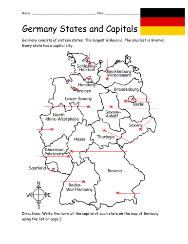
Introduce your students to the 16 states and capital cities of Germany with three worksheets (plus answer key). Using the list of states and capitals on page 2, your students will write the capital city of each state on the map of Germany (page 1). Then answer 8 true/false questions on page 3.
States - Capitals included:
Baden-Württemberg - Stuttgart
Bavaria - Munich
Berlin - Berlin
Brandenburg - Potsdam
Bremen - Bremen
Hamburg - Hamburg
Hesse - Wiesbaden
Lower Saxony - Hanover
Mecklenburg-Vorpommern - Shwerin
North Rhine-Westphalia - Düsseldorf
Rhineland-Palatinate - Mainz
Saarland - Saarbrücken
Saxony - Dresden
Saxony-Anhalt - Magdeburg
Schleswig-Holstein - Kiel
Thuringia - Erfurt
Thank you so much for using my worksheets in your classroom! I hope you find them useful. Reviews are welcome and very much appreciated. Please browse this store for more Geography worksheets!
Using the map of Germany, find the 16 states in the Word Search Puzzle.
States to find:
Baden-Württemberg
Bavaria
Berlin
Brandenburg
Bremen
Hamburg
Hesse
Lower Saxony
Mecklenburg-Vorpommern
North Rhine-Westphalia
Rhineland-Palatinate
Saarland
Saxony
Saxony-Anhalt
Schleswig-Holstein
Thuringia
(1) printable worksheet plus answer key.
Thank you so much for using my worksheets in your classroom! I hope you find them useful. Please browse this store for other worksheets! Reviews are welcome and very much appreciated!
Introduce your students to the 20 regions and capital cities of Italy with three worksheets (plus answer key). Using the list of regions and capitals on page 2, your students will write the capital city of each region on the map of Italy (page 1). Then answer 8 true/false questions on page 3.
Regions/Capitals included:
Region - Capital
Abruzzo - L’Aquila
Basilicata - Potenza
Calabria - Catanzaro
Campania - Naples
Emilia-Romagna - Bologna
Friuli-Venezia Giulia - Trieste
Lazio - Rome
Liguria - Genoa
Lombardy - Milan
Marche - Ancona
Molise - Campobasso
Piedmont - Turin
Puglia - Bari
Sardinia - Cagliari
Sicily - Palermo
Tuscany - Florence
Trentino-Alto Adige - Trento
Umbria - Perugia
Valle d’Aosta - Aosta
Veneto - Venice
Thank you so much for using my worksheets in your classroom! I hope you find them useful. Reviews are welcome and very much appreciated.
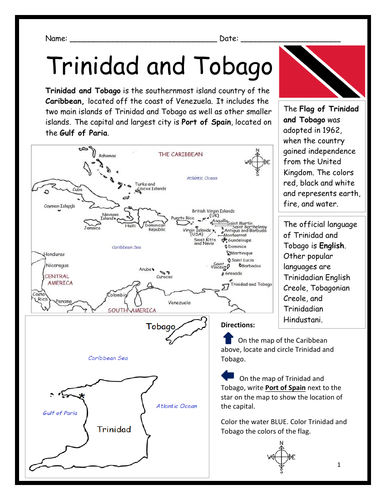
Introduce your learners to Trinidad and Tobago with two printable handouts (plus answer key). Your students will read a brief introduction to Trinidad and Tobago (location, capital, flag, language), write ‘Port of Spain’ next to the star on the map to show the location of the capital, locate and circle Trinidad and Tobago on the map of the Caribbean, color the map, and use the reading passage, maps and compass to answer 9 true/false questions on page 2. Colored pencils and a pen or pencil are needed for this activity. No other prep needed. Basic Geography worksheet with a simple map to introduce Trinidad and Tobago and practice cardinal and ordinal directions. Print and Go!
For use with Interactive Notebooks: After the worksheets are completed, students can cut out the map and flag and paste into the notebook under the topic of (example) The Caribbean / Sub-topic: Trinidad and Tobago. Under the map, your students can write a summary in their own words of what they now know about Trinidad and Tobago. Collect worksheets of other countries of the Caribbean to add to the notebook! All available in this store!
Thank you so much for using my Geography worksheets in your classroom! I hope you find them useful. Reviews are welcome and very much appreciated!
Included: Gulf of Paria, South America, United Kingdom
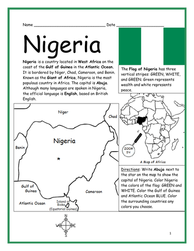
Introduce your students to Nigeria with this printable handout of two worksheets (plus answer key). Your students will read a brief introduction to Nigeria (location, capital, flag, language), write ‘Abuja’ next to the star on the map to show the capital, color the small map, and use the map and compass to answer 8 questions on page 2. Colored pencils and a pen or pencil are needed for this activity. Basic Geography worksheet includes a simple map to introduce the country of Nigeria and practice cardinal/ordinal directions.
For use with Interactive Notebooks: After the worksheets are completed, students can cut out the map and flag and paste into the notebook under the topic of Africa / Sub-topic: Nigeria. Under the map and flag, your students can write a summary in their own words of what they now know about this country. Collect worksheets for other countries of Africa to add to the notebook! Please see this store for a selection of printable worksheets for other countries of Africa (and beyond!).
Thank you so much for using my Geography worksheets in your classroom! I hope you find them useful. Reviews are welcome and very much appreciated!
Introduce your students to NEW ZEALAND with this printable handout of two worksheets (plus answer key). Your students will read a brief overview of New Zealand (location, capital, flag, language), write ‘Wellington’ next to the star on the map to show the capital, color the small map, and use the map and compass to answer 7 questions. Colored pencils and a pen or pencil are needed for this activity. Basic Geography worksheet with a simple map to introduce New Zealand and practice cardinal and ordinal directions.
For use with Interactive Notebooks: After the handout is completed, students can cut out the map and flag of New Zealand and paste into the notebook. Under the map and flag, students can write a summary in their own words of what they now know about New Zealand. Collect handouts for other countries to add to the notebook. Please check out my store for a selection of worksheets for other countries!
Thank you so much for using my Geography worksheets in your classroom. I hope you find them useful. Reviews are welcome and very much appreciated! Happy Teaching!
Included: Auckland, North Island, South Island, Cook Strait, Stewart Island, Pacific Ocean, Tasman Sea.
Introduce your students to GHANA in Africa with two worksheets (plus answer key). Your students will read a brief introductio to Ghana (location, capital, flag, language), write ‘Accra’ next to the star on the map to show the capital, color the small map, and use the map and compass to answer 9 questions on page 2. Colored pencils and a pen or pencil are needed for this activity. No other prep needed. Basic Geography worksheet with a simple map to introduce the country of Ghana and practice cardinal/ordinal directions.
For use with Interactive Notebooks: After the worksheets are completed, students can cut out the map and flag and paste into the notebook under the topic of Africa/Sub-topic: GHANA. Under the map and flag, your students can write a summary in their own words of what they now know about this country. Collect worksheets for other countries of Africa to add to the notebook! Please browse this store for a selection of printable handouts for other countries of Africa (and beyond!).
Thank you so much for using my Geography worksheets in your classroom!
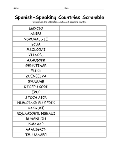
Unscramble each Spanish-speaking country using the list of countries on page 2. Countries included: Argentina, Bolivia, Chile, Colombia, Costa Rica, Cuba, Dominican Republic, Ecuador, El Salvador, Equatorial Guinea, Guatemala, Honduras, Mexico, Nicaragua, Panama, Paraguay, Peru, Puerto Rico, Spain Uruguay, Venezuela. Answer key included.
Thank you so much for using my handouts in your classroom!
Introduce your students to the country of INDONESIA with this printable handout of two worksheets (plus answer key). Your students will read a brief introduction to Indonesia (location, capital, language, flag), write ‘Jakarta’ next to the star on the map to show the location of the capital, trace the line of the equator, color the small map, and use the map and compass to answer 7 multiple-choice questions on page 2. Colored pencils and a pen or pencil are needed for this activity. No other prep needed. Basic Geography worksheet with a simple map to introduce Indonesia in Asia.
For use with Interactive Notebooks: After the worksheets are completed, students can cut out the map and flag and paste into the notebook under the topic Asia/Sub-topic: Indonesia. Under the map, your students can write a summary in their own words of what they now know about this country. Collect worksheets for other countries of Asia to add to the notebook! Please browse this store for a selection of worksheets for all other countries of Asia (and beyond!).
Thank you so much for using my Geography worksheets in your classroom! I hope you find them useful. Reviews are welcome and very much appreciated.
Included: Indian Ocean, Pacific Ocean, Java, Sumatra, Borneo, Sulawesi, New Guinea, Malaysia.
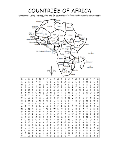
Using the map, find the 54 countries of Africa in this printable Word Search Puzzle! One printable word search puzzle with map (plus answer key).
Countries to find: ALGERIA, ANGOLA, BENIN, BOTSWANA, BURKINA FASO, BURUNDI, CAMEROON, CAPE VERDE, CENTRAL AFRICAN REPUBLIC, CHAD, COMOROS, DJIBOUTI, ESWATINI, GABON, KENYA, EGYPT, EQUATORIAL GUINEA, ERITREA, ETHIOPIA, DR CONGO, CONGO, THE GAMBIA, GHANA, GUINEA, GUINEA-BISSAU, IVORY COAST, LESOTHO, LIBERIA, LIBYA, MADAGASCAR, MALAWI, MALI, MAURITANIA, MAURITIUS, MOROCCO, MOZAMBIQUE, NAMIBIA, NIGER, NIGERIA, RWANDA, SAO TOME AND PRINCIPE, SENEGAL, SEYCHELLES, SIERRA LEONE, SOMALIA, SOUTH AFRICA, SOUTH SUDAN, SUDAN, TANZANIA, TOGO, TUNISIA, UGANDA, WESTERN SAHARA, ZIMBABWE
To introduce your learners to each country of Africa, please browse this store for printable worksheets!
Thank you so much for using my Geography worksheets in your classroom! I hope you find them useful. Reviews are welcome and very much appreciated.
Introduce your learners to Albania in Europe with this printable handout of two worksheets (plus answer key). Your students will read a brief introduction to Albania (location, capital, flag, language), write ‘Tirana’ next to the star on the map to show the location of the capital, color the small map, and use the map and compass to answer 7 questions on page 2. Colored pencils and a pen or pencil are needed for this activity. No other prep needed. Basic Geography worksheet with a simple map to introduce Albania and practice cardinal and ordinal directions.
For use with Interactive Notebooks: After completing the worksheets for Albania, students can cut out the map and flag and paste into the notebook under the topic of Europe / Sub-Topic: Albania. Under the map and flag, students can write a summary in their own words of what they now know about this country. Collect worksheets for other countries of Europe to add to the notebook! Please browse this store for a selection of worksheets for other countries of Europe (and beyond!).
Thank you so much for using my Geography worksheets in your classroom! I hope you find them useful and fun. Reviews are welcome and very much appreciated. :)
Introduce your students to the country of SAN MARINO with two worksheets (plus answer key). Your students will read a brief introduction to San Marino (location, capital, flag, language), write ‘City of San Marino’ next to the star on the map to show the location of the capital, color the small map, and use the map and compass to answer 6 multiple-choice questions on page 2. Colored pencils and a pen or pencil are needed for this activity. No other prep needed. Basic Geography worksheet with a simple map to introduce the country of San Marino and practice cardinal and ordinal directions.
For use with Interactive Notebooks: After completing the worksheets, students can cut out the map and flag and paste into the notebook under the topic of Europe/Sub-Topic: San Marino. Under the map and flag, students can write a summary in their own words of what they now know about this country. Collect worksheets for other countries of Europe to add to the notebook! Please browse this store for the list of worksheets for other countries of Europe (and beyond!).
Thank you so much for using my Geography worksheets in your classroom! I hope you find them useful. Reviews are welcome and very much appreciated.
Introduce your students to the country of JORDAN with two worksheets (plus answer key). Your students will read a brief introduction to Jordan (location, capital, language, flag), write ‘Amman’ next to the star on the map to show the location of the capital, color the small map, and use the map and compass to answer 9 questions on page 2. Colored pencils and a pen or pencil are needed for this activity. No other prep needed. Basic Geography worksheet with a simple map to introduce Jordan and practice cardinal/ordinal directions.
For use with Interactive Notebooks: After the worksheets are completed, students can cut out the map and flag an paste into the notebook under the topic of Asia or Middle East /Sub-topic: Jordan. Under the map, your students can write a summary in their own words of what they now know about this country. Collect worksheets for other countries of Asia or Middle East to add to the notebook! All available in this store. Please browse this store for a selection of printable Geography worksheets for other countries of Asia, Middle East and beyond!
Thank you so much for using my Geography worksheets in your classroom! I hope you find them useful. Reviews are welcome and very much appreciated!
Hashemite Kingdom of Jordan, Western Asia, Middle East, Saudi Arabia, Iraq, Syria, Israel, Palestinian West Ban, Dead Sea, Red Sea, Amman, Arabic, Pan-Arab, Al-Fatiha
Introduce your students to UKRAINE with this printable handout of two worksheets (plus answer key). Your students will read a brief introduction to Ukraine (location, capital, flag, language), write 'Kiev' next to the star on the map to show the location of the capital, color the small map and flag, and use the map and compass to answer 7 questions on page 2. Colored pencils and a pen or pencil are needed for this activity. No other prep needed. Basic Geography worksheet with a simple map to introduce the Ukraine and practice cardinal and ordinal directions.
For use with Interactive Notebooks: After the worksheets are completed, students can cut out the map and flag and paste into the notebook under the topic of Europe/Sub-Topic: Ukraine. Under the map, students can write a summary in their own words of what they now know about this country. Collect worksheets for other countries of Europe to add to the notebook! All available in this store. Please browse this store for a selection of printable handouts for other countries of Europe (and beyond!).
Thank you so much for using my Geography worksheets in your classroom! I hope you find them useful. Reviews are welcome and very much appreciated!