Thank you for visiting! Here you will find a selection of printable, interactive worksheets for your classroom: Basic Geography worksheets with simple maps, ESL, Spanish, Bible, Reading Comprehension and more. I hope you find the resources useful! Reviews are welcome and very much appreciated. Thank you so much.
Thank you for visiting! Here you will find a selection of printable, interactive worksheets for your classroom: Basic Geography worksheets with simple maps, ESL, Spanish, Bible, Reading Comprehension and more. I hope you find the resources useful! Reviews are welcome and very much appreciated. Thank you so much.
Introduce your students to Bolivia with this printable handout of two worksheets (plus answer key). Your students will read a brief overview of Bolivia (location, capital, flag, language), write 'Sucre' next to the star on the map to show the capital, color the small map and flag, and use the map and compass to answer 7 questions. Colored pencils and a pen or pencil are needed for this activity. No other prep needed. Basic Geography worksheet with a simple map to introduce Bolivia and practice cardinal and ordinal directions.
For use with Interactive Notebooks: After the handout is completed, students can cut out the map and flag and paste into the notebook under the topic of South America/Sub-topic: Bolivia. Under the map, students will write a summary in their own words of what they now know about this country. Collect handouts for other countries of South America to add to the notebook! Please browse this store for a selection of printable handouts for other countries of South America (and beyond!).
Thank you so much for using my Geography worksheets in your classroom!
Introduce your students to COLOMBIA in South America with two printable worksheets (plus answer key). Your students will read a brief introduction to Colombia (location, capital, language, flag), write Bogotá next to the star on the map to show the location of the capital, color the map, and use the map and compass to answer (7) questions on page 2. Colored pencils and a pen or pencil are needed for this activity. No other prep needed. Basic Geography worksheet with a simple map to introduce Colombia and practice cardinal and ordinal directions.
For use with Interactive Notebooks: After the worksheets are completed, students can cut out the map and flag and paste into the notebook under the topic of South America/Sub-topic: Colombia. Under the map, they can write a summary in their own words of what they now know about this country. Collect handouts for other countries of South America to add to the notebook! All available in this store. Please browse this store for a selection of printable handouts for other countries of South America (and beyond!).
Thank you so much for using my Geography worksheets in your classroom! I hope you find them useful. Reviews are welcome and very much appreciated!
Introduce your students to Honduras with this printable handout of two worksheets (plus answer key). Your students will read a brief introduction to Honduras (location, capital, flag, language), write 'Tegucigalpa' next to the star on the map to show the capital, color a small map and flag, and use the map and compass to answer 6 questions on page 2. Colored pencils and a pen or pencil are needed for this activity. No other prep needed. Basic Geography worksheet with a simple map to introduce Honduras and practice cardinal and ordinal directions.
For use with Interactive Notebooks: After the worksheets are completed, students can cut out the map and flag and paste into the notebook under the topic of Central America/Sub-Topic: Honduras. Under the map, your students can write a summary in their own words of what they now know about this country. Collect worksheets for all countries of Central America to add to the notebook! Please browse this store for a selection of printable handouts for other countries of Central America (and beyond!).
Thank you so much for using my Geography worksheets in your classroom! I hope you find them useful. Reviews are welcome and very much appreciated!
Introduce your students to El Salvador with two printable worksheets (plus answer key). Your students will read a brief introduction to El Salvador (location, capital, flag, language), write 'San Salvador' next to the star on the map to show the capital, color the small map and flag, and use the map and compass to answer 7 questions on page 2. Colored pencils and a pen or pencil needed for this activity. No other prep needed. Basic Geography worksheet with a simple map to introduce El Salvador and practice cardinal and ordinal directions.
For use with Interactive Notebooks: After the worksheets are completed, students can cut out the map and flag and paste into the notebook under the topic of Central America (or Spanish-Speaking Countries)/Sub-topic: El Salvador. Under the map and flag, students can write a summary in their own words about what they now know about this country. Collect worksheets for other countries of Central America (or Spanish-speaking countries) to add to the notebook! All available in this store! Please browse this store for a selection of worksheets for countries of Central America (and beyond!).
Thank you so much for using my Geography worksheets in your classroom! I hope you find them useful. Reviews are welcome and very much appreciated!
This printable handout of 2 pages (plus answer key) includes a map and flag of Colombia. Your students will fill in the blanks for each Colombia and surrounding countries (Venezuela, Brazil, Peru, Ecuador, and Panama) and the Atlantic and Pacific Ocean, write Bogotá next to the star on the map to show the capital of Colombia, color the flag and map, and then use the map and compass to answer 7 questions.
This printable handout of one page includes a map of South America. Your students will write each country of South America on the map, using the list of countries to fill in the blanks: Argentina, Bolivia, Brazil, Chile, Colombia, Ecuador, French Guiana, Guyana, Paraguay, Peru, Suriname, Uruguay, and Venezuela, as well as the Pacific Ocean and Atlantic Ocean. Then your students can color the map. Colored pencils or crayons and a pen or pencil are needed for this activity. No other prep needed.
Introduce your students to IRAQ with this printable handout of two worksheets (plus answer key). Your students will read a brief introduction to Iraq (location, capital, flag, language), write ‘Baghdad’ next to the star on the map to show the capital, color the small flag and map, and use the map and compass to answer 9 questions on page 2. Colored pencils and a pen or pencil are needed for this activity. No other prep needed. Basic Geography worksheet with a simple map to introduce Iraq and practice cardinal and ordinal directions.
For use with Interactive Notebooks: After the worksheets are completed, students can cut out the map and flag and paste into the notebook under the topic of Asia / Sub-Topic: Iraq. Under the map, students can write a summary in their own words of what they now know about this country. Collect worksheets for other countries of Asia to add to the notebook! Please browse this store for worsheets for all other countries of Asia (and beyond!).
Thank you so much for using my Geography worksheets in your classroom! I hope you find them useful. Reviews are welcome and very much appreciated!
Tigris River, Euphrates River, Cardinal, Ordinal directions.
Introduce your students to Japan with this printable handout of two worksheets (plus answer key). Your students will read a brief introductin to Japan (location, capital, flag, language), write ‘Tokyo’ next to the star on the map to show the location of the capital, color the small map and flag, and use the map and compass to answer 7 questions on page 2. Colored pencils and a pen or pencil are needed for this activity. No other prep needed. Basic Geography worksheet with a simple map to introduce Japan and practice cardinal and ordinal directions.
For use with Interactive Notebooks: After the worksheets are completed, students can cut out the map and flag and paste into the notebook under the topic of Asia / Sub-Topic: Japan. Under the map and flag, your students can write a summary in their own words of what they now know about this country. Collect handouts for other countries of Asia to add to the notebook! Please browse this store for a selection of worksheets for all other countries of Asia (and beyond!)
Thank you so much for using my Geography worksheets in your classroom! I hope you find them useful. Reviews are welcome and very much appreciated!
Japanese Archipelago, Islands of Honshu, Hokkaido, Kyushu, Shikoku.
Nisshōki, Hinomaru, Maritime borders. Dialect. Okinawa, Ryukyu Islands.
Introduce your students to the United States of America with two worksheets (plus answer key). Your students will read a brief introduction to the United States (location, capital, flag, language, 13 original colonies), write ‘Washington D.C.’ next to the star on the map to show the location of the capital, color the small map, and use the map and compass to answer 10 questions on page 2.
Please note: This map includes the United States and surrounding, including Canada, Mexico, Atlantic Ocean, Pacific Ocean, Arctic Ocean, Gulf of Mexico, Cuba, Haiti, Dominican Republic, Puerto Rico. Individual states of America are not included on this map (except for Alaska, Hawaii and 13 original colonies). For worksheets to introduce your learners to each of the 50 states of the USA, please browse this store!
For use with Interactive Notebooks: After the worksheet is completed, students can cut out the map and flag and paste into the notebook under the topic of North America/Sub-Topic: United States. Under the map and flag, students can write a summary in their own words of what they now know about the United States of America! Collect worksheets for other countries of North America to add to the notebook! Please browse this store for worksheets to introduce your learners to countries of North America, such as Canada, Mexico, Cuba, Dominican Republic, Haiti, Puerto Rico, and countries of Central America!
Thank you so much for using my Geography worksheets in your classroom! I hope you find them useful. Reviews are welcome and very much appreciated.
Included: Washington D.C. formerly District of Columbia, named after first president and Founding Father George Washington.
Introduce your students to Bangladesh with this printable handout of two worksheets (plus answer key). Your students will read a brief introduction to Bangladesh (location, capital, flag, language), write ‘Dhaka’ next to the star on the map to show the location of the capital, color the small map and flag, and use the map and compass to answer 6 questions on page 2. Colored pencils and a pen or pencil are needed for this activity. No other prep needed. Basic Geography worksheet with a simple map to introduce Bangladesh and practice cardinal and ordinal directions.
For use with Interactive Notebooks: After the worksheets are completed, students can cut out the map and flag and paste into the notebook under the topic of Asia / Sub-topic: Bangladesh. Under the map and flag, students can write a summary in their own words of what they now know about this country. Collect worksheets for other countries of Asia to add to the notebook! Please browse this store for a selection of worksheets for countries of Asia (and beyond!)
Thank you for using my Geography worksheets in your classroom! I hope you find them useful. Reviews are welcome and very much appreciated!
Introduce your students to PORTUGAL with two worksheets (plus answer key). Your students will read a brief introduction to Portugal (location, capital, flag, language), write ‘Lisbon’ next to the star on the map to show the location of the capital, color the small flag and map, and use the map and compass to answer 6 questions on page 2. Colored pencils and a pen or pencil are needed for this activity. No other prep needed. Basic Geography worksheet with a simple map to introduce Portugal and practice cardinal and ordinal directions.
For use with Interactive Notebooks: After completing the worksheets, students can cut out the map and flag and paste into the notebook under the topic of Europe / Sub-Topic: Portugal. Under the map and flag, students can write a summary in their own words of what they now know about this country. Collect worksheets for other countries of Europe to add to the notebook! Please browse this store for worksheets for other countries of Europe (and beyond!).
Thank you so much for using my Geography worksheets in your classroom. I hope you find them useful! Reviews are welcome and very much appreciated.
Introduce your students to the country of GEORGIA with this printable handout of two worksheets (plus answer key). Your students will read a short introductory passage about Georgia (location, capital, flag, language), write ‘Tbilisi’ next to the star on the map to show the location of the capital, color the small map and flag, and use the map and compass to answer 7 questions on page 2. Colored pencils and a pen or pencil are needed for this activity. No other prep needed. Basic Geography worksheet with a simple map to introduce the country of Georgia and practice cardinal and ordinal directions.
For use with Interactive Notebooks: After completing the worksheets, students can cut out the map and flag and paste it into the notebook under the topic of Europe (or Asia or Eurasia) / Sub-Topic: Georgia. Under the map and flag, students can write a summary in their own words of what they now know about the country of Georgia. Collect worksheets for other countries to add to the notebook! Please browse this store for a selection of worksheets for other countries of Europe, Asia, and beyond!
Thank you so much for using my Geography worksheets in your classroom! Reviews are welcome and very much appreciated.
Caucasus region, Black Sea, Caspian Sea, cardinal and ordinal directions.
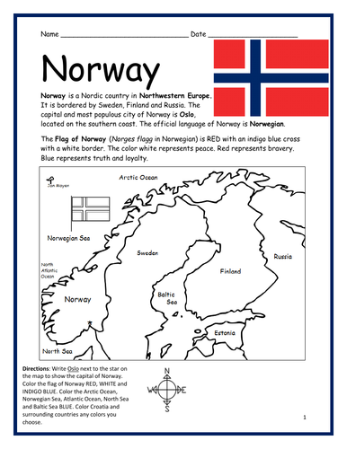
Introduce your learners to NORWAY with this two worksheets (plus answer key). Your students will read a brief introduction to Norway (location, capital, flag, language), write ‘Oslo’ next to the star on the map to show the location of the capital, color the small flag and map, and use the map and compass to answer 6 questions on page 2. Colored pencils and a pen or pencil are needed for this activity. No other prep needed. Basic Geography worksheet with a simple map to introduce Norway and practice cardinal and ordinal directions.
For use with Interactive Notebooks: After completing the worksheets, students can cut out the map and flag of Norway and paste into the notebook under the topic of Europe / Sub-Topic: Norway. Under the map and flag, students can write a summary in their own words of what they now know about this country. Collect worksheets for other countries of Europe to add to the notebook! Please browse this store for worksheets for other countries of Europe (and beyond!).
Thank you so much for using my Geography worksheets in your classroom! Reviews are welcome and very much appreciated.
Introduce your students to Belgium with this printable handout of two worksheets (plus answer key). Your students will read a brief introduction to Belgium (location, capital, flag, language), write ‘Brussels’ next to the star on the map to show the capital, color the small flag and map, and use the map and compass to answer 7 questions on page 2. Colored pencils and a pen or pencil are needed for this activity. No other pep needed. Basic Geography worksheet with a simple map to introduce Belgium and practice cardinal and ordinal directions.
For use with Interactive Notebooks: After the worksheets are completed, students can cut out the map and flag and paste into the notebook under the topic of Europe/Sub-Topic: Belgium. Under the map and flag, students can write a summary in their own words of what they now know about this country. Collect worksheets for other countries of Europe to add to the notebook! All available in this store! Please browse this store for a selection of worksheets for other countries of Europe (and beyond!).
Thank you so much for using my Geography worksheets in your classroom! I hope you find them useful. Reviews are welcome and very much appreciated!
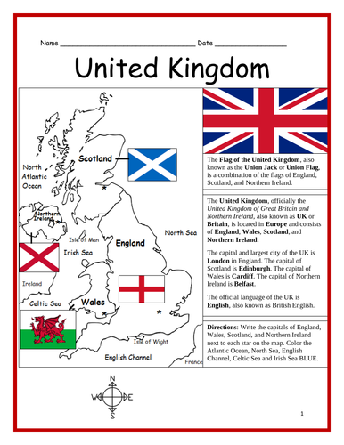
Introduce your learners to the United Kingdom with three interactive worksheets (plus answer key). Page 1: Your learners will read a brief introduction to the United Kingdom (location, capital, flag, language), write the capital of England, Scotland, Wales and Northern Ireland next to each star on the map, and color the water surrounding the UK BLUE. Page 2: Use the map and compass to answer 6 multiple choice questions. Page 3: Match the flag to the country: England, Scotland, Wales and Northern Ireland. Page 4: Answer Key. Basic Geography worksheet with a simple map to introduce the United Kingdom.
For use with Interactive Notebooks: After completing the worksheets, students can cut out the map and flag and paste into the notebook under the topic of Europe / Sub-Topic: United Kingdom. Under the map and flag, students can write a summary in their own words of what they now know about the UK. Collect worksheets for other countries of Europe to add to the notebook! Please browse this store for worksheets for other countries of Europe (and beyond!).
Thank you for using my Geography worksheets in your classroom! I hope you find them useful! Reviews are welcome and very much appreciated.
Introduce your students to the country of MONACO with two worksheets (plus answer key). Your students will read an introduction to Monaco (location, capital, flag, language), write ‘Monte Carlo’ next to the star on the map to show the location of the capital, color a small map and flag, and use the map and compass to answer 6 multiple-choice questions on page 2. Colored pencils and a pen or pencil are needed for this activity. No other prep needed. Basic Geography worksheet with a simple map to introduce the country of Monaco and practice cardinal and ordinal directions.
For use with Interactive Notebooks: After completing the worksheets, students can cut out the map and flag and paste into the notebook under the topic of Europe / Sub-Topic: Monaco. Under the map and flag, students can write a summary in their own words of what they now know about this country. Collect worksheets for other countries of Europe to add to the notebook! Please browse this store for a selection of worksheets for other countries of Europe (and beyond!)
Thank you so much for using my Geography worksheets in your classroom! I hope you find them useful. Reviews are welcome and very much appreciated!
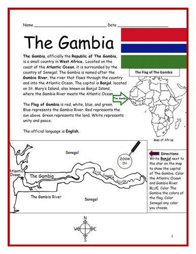
Introduce your students to THE GAMBIA in Africa with this printable handout of two worksheets (plus answer key). Your students will read a brief introduction to The Gambia (location, capital, flag, language), write ‘Banjul’ next to the star on the map to show the capital, color the small map, and use the map and compass to answer 7 questions on page 2. Colored pencils and a pen or pencil are needed for this activity. No other prep needed. Basic Geography worksheet includes a simple map to introduce The Gambia and practice cardinal/ordinal directions.
For use with Interactive Notebooks: After the worksheets are completed, students can cut out the map and flag and paste into the notebook under the topic of Africa/Sub-topic: The Gambia. Under the map and flag, your students can write a summary in their own words of what they now know about this country. Collect handouts for other countries of Africa to add to the notebook! Please browse this store for a selection of printable Geography worksheets for other countries of Africa (and beyond!).
Thank you so much for using my Geography worksheets in your classroom! I hope you find them useful. Reviews are welcome and very much appreciated!
Introduce your students to the country of SENEGAL in West Africa with this printable handout of two worksheets (plus answer key). Your students will read a brief overview of Senegal (location, capital, flag, language), write ‘Dakar’ next to the star on the map to show the capital, write ‘Casamance’ in the area of Senegal south of The Gambia, color the small map, and use the map and compass to answer 10 questions on page 2. Colored pencils and a pen or pencil are needed for this activity. No other prep needed. Basic Geography worksheet with a simple map to introduce the country of Senegal and practice cardinal/ordinal directions.
For use with Interactive Notebooks: After the handout is completed, students can cut out the map and flag and paste into the notebook under the topic of Africa/Sub-topic: Senegal. Under the map and flag, your students can write a summary in their own words of what they now know about this country. Collect handouts for other countries of Africa to add to the notebook! Please browse this store for a selection of printable handouts for other countries of Africa (and beyond!).
Thank you so much for using my Geography worksheets in your classroom!
Introduce your learners to the country of Yemen with this printable handout of two worksheets (plus answer key). Your students will read a brief introduction to Yemen (location, capital, language, flag), write ‘Sana’a’ next to the star on the map to show the capital (Aden declared as the temporary capital in 2015), color the small map, and use the map and compass to answer 6 multiple-choice questions on page 2. Colored pencils and a pen or pencil are needed for this activity. No other prep needed. Basic Geography worksheet with a simple map to introduce Yemen and practice cardinal/ordinal directions.
For use with Interactive Notebooks: After your students complete the worksheets, they can cut out the map and flag and paste into the notebook under the topic of Asia or Middle East / Sub-topic: Yemen. Under the map, students can write a summary in their own words of what they now know about this country. Collect worksheets for other countries of Asia or Middle East to add to the notebook! All available in this store! Please browse this store for a selection of printable worksheets for other countries of the Middle East and Asia (and beyond!)
Thank you so much for using my Geography worksheets in your classroom! I hope you find them useful. Reviews are welcome and very much appreciated!
Using the map of the island of Hispaniola, find the countries, capitals, islands and surrounding in the Word Search Puzzle: HAITI, DOMINICAN REPUBLIC, PORT-AU-PRINCE, SANTO DOMINGO, SAONA ISLAND, BEATA ISLAND, TORTUGA ISLAND, GONAVE ISLAND, LES CAYEMITES, ILE-A-VACHE ISLAND, ATLANTIC OCEAN, CARIBBEAN SEA, CUBA. Then write the remaining letters below to spell out a fact about the island of Hispaniola! The remaining letters will spell out the following: When Christopher Columbus landed on this island of Hispaniola in 1492, he named it La Isla Espanola, which means The Spanish island.
Answer key included.
Thank you for using my worksheets in your classroom! Please browse this store for more Geography worksheets and Word Search Puzzles.