Thank you for visiting! Here you will find a selection of printable, interactive worksheets for your classroom: Basic Geography worksheets with simple maps, ESL, Spanish, Bible, Reading Comprehension and more. I hope you find the resources useful! Reviews are welcome and very much appreciated. Thank you so much.
Thank you for visiting! Here you will find a selection of printable, interactive worksheets for your classroom: Basic Geography worksheets with simple maps, ESL, Spanish, Bible, Reading Comprehension and more. I hope you find the resources useful! Reviews are welcome and very much appreciated. Thank you so much.
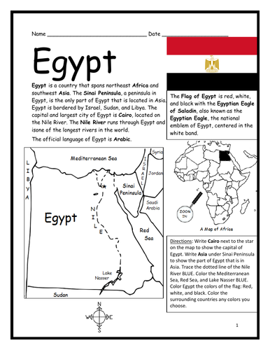
Introduce your students to Egypt with two worksheets (plus answer key). Your students will read a brief introduction to Egypt (location, capital, flag, language), write ‘Cairo’ next to the star on the map to show the location of the capital, write ‘Asia’ under the Sinai Peninsula to show the part of Egypt that is located in Asia, trace the dotted line of the Nile River, color the small map, and use the map and compass to answer 9 questions on page 2. Colored pencils and a pen or pencil are needed for this activity. No other prep needed. Basic Geography worksheet with a simple map to introduce the country of Egypt and practice cardinal/ordinal directions.
For use with Interactive Notebooks: After the worksheets are completed, students can cut out the map and flag and paste into the notebook under the topic of Africa, Asia, or Middle East / Sub-topic: Egypt. Under the map and flag, your students can write a summary in their own words of what they now know about this country. Collect worksheets for other countries of Africa, Asia or the Middle East to add to the notebook! Please browse this store for a selection of worksheets for countries of Africa or Asia (and beyond!)
Thank you so much for using my Geography worksheets in your classroom! I hope you find them useful. Reviews are welcome and very much appreciated.
Introduce your students to the country of ALGERIA in Africa with two worksheets (plus answer key). Your students will read a brief introduction to Algeria (location, capital, flag, language), write ‘Algiers’ next to the star on the map to show the location of the capital, color the small map, and use the map and compass to answer 9 questions on page 2. Colored pencils and a pen or pencil are needed for this activity. No other prep needed. Basic Geography worksheet with a simple map to introduce the country of Algeria and practice cardinal/ordinal directions.
For use with Interactive Notebooks: After the worksheets are completed, students can cut out the map and flag and paste into the notebook under the topic of Africa/Sub-topic: Algeria. Under the map and flag, your students will write a summary in their own words of what they now know about this country. Collect worksheets for other countries of Africa to add to the notebook! Please browse this store for a selection of worksheets for other countries of Africa (and beyond!).
Thank you so much for using my worksheets in your classroom! I hope you find them useful. Reviews are welcome and very much appreciated!
Introduce your students to SEYCHELLES with two worksheets (plus answer key). Your students will read a brief introduction to Seychelles (location, capital, flag, language), write ‘Victoria’ next to the star on the map to show the location of the capital, color the small map, and answer 7 questions on page 2. Colored pencils and a pen or pencil are needed for this activity. No other prep needed. Basic Geography worksheet with a simple map to introduce Seychelles. Included on this map are the three main islands of Mahé, Praslin, and La Digue, and 16 other islands (out of 115) including: Aride, Cerf, Conception, Cousin, Cousine, Curieuse, Félicité, Frégate, Grand Soeur, Île aux Récifs, Marianne, North Island, Petite Soeur, Sainte Anne, Silhouette, and Thérèse.
For use with Interactive Notebooks: After the worksheets are completed, students can cut out the map and flag and paste into the notebook under the topic of Africa / Sub-topic: Seychelles. Under the map and flag, your students can write a summary in their own words of what they now know about this country. Collect worksheets for other countries of Africa to add to the notebook! Available individually or as a discounted COUNTRIES OF AFRICA BUNDLE! Please browse this store for a selection of printable worksheets for other countries of Africa (and beyond)!
Thank you so much for using my Geography worksheets in your classroom! I hope you find them useful. Reviews are welcome and very much appreciated!
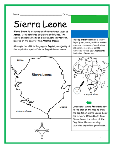
Introduce your students to Sierra Leone with two worksheets (plus answer key). Your students will read a brief introduction to Sierra Leone (location, capital, flag, language), write ‘Freetown’ next to the star on the map to show the location of the capital, color the small map, and use the map and compass to answer 6 questions on page 2. Colored pencils and a pen or pencil are needed for this activity. Basic Geography worksheet with a simple map to introduce Sierra Leone and practice cardinal and ordinal directions.
For use with Interactive Notebooks: After the worksheets are completed, students can cut out the map and flag and paste into the notebook under the topic of Africa/Sub-topic: Sierra Leone. Under the map and flag, your students can write a summary in their own words of what they now know about this country. Collect worksheets for other countries of Africa to add to the notebook! Please browse this store for a selection of worksheets for other countries of Africa (and beyond!)
Thank you so much for using my Geography worksheets in your classroom! I hope you find them useful. Reviews are welcome and very much appreciated.
Introduce your students to GUINEA with two worksheets (plus answer key). Your students will read a brief introduction to Guinea (location, capital, flag, language), write ‘Conakry’ next to the star on the map to show the location of the capital, color the small map, and use the map and compass to answer 8 questions. Colored pencils and a pen or pencil are needed for this activity. No other prep needed. Basic Geography worksheet with a simple map to introduce the country of Guinea and practice cardinal and ordinal directions.
For use with Interactive Notebooks: After the worksheets are completed, students can cut out the map and flag and paste into the notebook under the topic of Africa/Sub-topic: Guinea. Under the map and flag, your students can write a summary in their own words of what they now know about this country. Collect worksheets for other countries of Africa to add to the notebook! Please browse this store for a selection of printable worksheets for other countries of Africa (and beyond!).
Thank you so much for using my Geography worksheets in your classroom! I hope you find them useful. Reviews are welcome and very much appreciated. :)
Introduce your students to the South Pole with this printable handout of two worksheets (plus answer key). Your students will read a brief overview of the South Pole, trace the line of the Antarctic Circle, color the map of the South Pole and surrounding (Antarctica, Southern Ocean, Atlantic Ocean, Pacific Ocean, Indian Ocean, South America, Africa, Australia) and answer 7 questions on page 2.
For use with Interactive Notebooks: After the handout is completed, cut out the map and paste into the notebook under the topic of The South Pole. Under the map, your students will write a summary in their own words of what they now know about the South Pole. Collect handouts for surrounding continents/countries to add to the notebook!
Thank you so much for using my Geography worksheets in your classroom! Reviews are welcome and very much appreciated.
Introduce your students to Ethiopia with two worksheets (plus answer key). Your students will read a brief introduction to Ethiopia (location, capital, flag, language), write ‘Addis Ababa’ next to the star on the map to show the location of the capital, color the small map, and use the map and compass to answer 8 questions on page 2. Colored pencils and a pen or pencil are needed for this activity. No other prep needed. Basic Geography worksheet includes a simple map to introduce the country of Ethiopia and practice cardinal/ordinal directions.
For use with Interactive Notebooks: After the worksheets are completed, students can cut out the map and flag and paste into the notebook under the topic of Africa / Sub-topic: Ethiopia. Under the map and flag, your students can write a summary in their own words of what they now know about Ethiopia. Collect worksheets for other countries of Africa to add to the notebook! Please browse this store for worksheets for other countries of Africa (and beyond!).
Thank you so much for using my Geography worksheets in your classroom! I hope you find them useful. Reviews are welcome and very much appreciated!
Introduce your students to MOROCCO with two worksheets (plus answer key). Your students will read a brief introduction to Morocco (location, capital, flag, language), write ‘Rabat’ next to the star on the map to show the location of the capital, color the small map, and use the map and compass to answer 8 questions on page 2. Colored pencils and a pen or pencil are needed for this activity. No other prep needed. Basic Geography worksheet with a simple map to introduce Morocco and practice cardinal and ordinal directions.
For use with Interactive Notebooks: After the worksheets are completed, students can cut out the map and flag and paste into the notebook under the topic of Africa/Sub-topic: Morocco. Under the map and flag, your students can write a summary in their own words of what they now know about this country. Collect worksheets for other countries of Africa to add to the notebook! Please browse this store for a selection of worksheets for other countries of Africa (and beyond!).
Thank you so much for using my Geography worksheets in your classroom! I hope you find them useful. Reviews are welcome and very much appreciated.
Introduce your learners to MADAGASCAR in Africa with two worksheets (plus answer key). Your students will read a brief introduction to Madagascar (location, capital, flag, language), write ‘Antananarivo’ next to the star on the map to show the location of the capital, color the small map, and use the map and compass to answer 6 multiple-choice questions on page 2. Colored pencils and a pen or pencil are needed for this activity. No other prep needed. Basic Geography worksheet with a simple map to introduce the country of Madagascar and practice cardinal/ordinal directions.
For use with Interactive Notebooks: After the worksheets are completed, students can cut out the map and flag and paste into the notebook under the topic of Africa / Sub-topic: Madagascar. Under the map and flag, your students can write a summary in their own words of what they now know about this country. Collect worksheets for other countries of Africa to add to the notebook! All available in this store!
Thank you so much for using my Geography worksheets in your classroom! I hope you find them useful. Reviews are welcome and very much appreciated! Please browse this store for worksheets to introduce your learners to all countries of Africa and the world!
Introduce your students to the 7 continents with this printable handout of 2 worksheets (plus answer key). Your students will write the name of each continent on the map: Africa, Antarctica, Asia, Europe, North America, Oceania (Australia), and South America, trace the line of the equator, color the small map, and use the map and compass to answer 7 questions. Colored pencils and a pen or pencil are needed for this activity. No other prep needed. Basic geography worksheet with a simple map to introduce the continents and practice cardinal and ordinal directions.
For use with Interactive Notebooks: After the handout is completed, students can cut out the map of the 7 continents and paste into the notebook. Under the map, students can write a summary in their own words of what they now know about the continents. Collect handouts for countries of Africa, Antarctica, Asia, Europe, North America, Oceania/Australia, and South America to add to the notebook! Please browse this store for a selection of printable handouts.
Thank you so much for using my Geography worksheets in your classroom! I hope you find them useful!
Introduce your students to GUINEA-BISSAU with two worksheets (plus answer key). Your students will read a brief introduction to Guinea-Bissau (location, capital, flag, language), write ‘Bissau’ next to the star on the map to show the location of the capital, color the small map, and use the map and compass to answer 8 questions on page 2. Colored pencils and a pen or pencil are needed for this activity. No other prep needed. Basic Geography worksheet with a simple map to introduce the country of Guinea-Bissau and practice cardinal and ordinal directions.
For use with Interactive Notebooks: After the worksheets are completed, students can cut out the map and flag and paste into the notebook under the topic of Africa/Sub-topic: Guinea-Bissau. Under the map and flag, your students can write a summary in their own words of what they now know about this country. Collect worksheets for other countries of Africa to add to the notebook! Please browse this store for worksheets for other countries of Africa (and beyond!)
Thank you so much for using my Geography worksheets in your classroom! I hope you find them useful Reviews are welcome and very much appreciated.
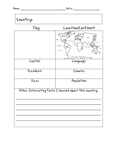
Assign a country or have your students choose a country to learn about on their own. With this printable blank ‘Country Fact Sheet,’ your students will write the name of the assigned country, find the location of that country on the map of the 7 continents, write the country’s capital, language, president, climate, size, population, and list any other interesting facts they learned in their research.
Great for homework and independent study.
Thank you so much for using my printable handouts in your classroom! I hope you find them useful. Reviews are welcome and very much appreciated! Please browse this store for more worksheets to introduce your learners to the countries of the world!
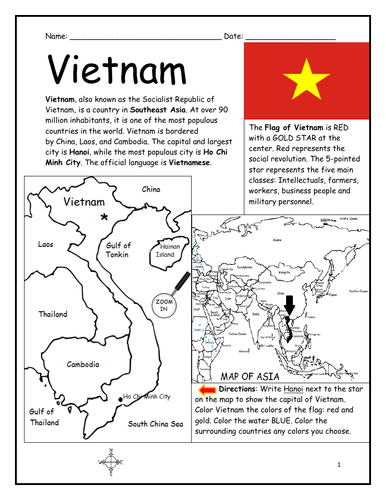
Introduce your students to VIETNAM with this printable handout of two worksheets (plus answer key). Your students will read a brief introduction to Vietnam (location, capital, flag, language), write 'Hanoi’ next to the star on the map to show the capital, color the small map of Vietnam and surrounding, and use the map and compass to answer 7 questions on page 2. Colored pencils and a pen or pencil are needed for this activity. No other prep needed. Basic Geography worksheet with a simple map to introduce Vietnam and practice cardinal and ordinal directions.
For use with Interactive Notebooks: After the worksheets are completed, students can cut out the map and flag and paste into the notebook under the topic of Asia/Sub-Topic: Vietnam. Under the map and flag, your students can write a summary in their own words of what they now know about Vietnam. Collect handouts for other countries of Asia to add to the notebook! All available in this store. Please browse this store for a selection of printable Geography worksheets for countries of Asia (and beyond!).
Thank you for using my Geography worksheets in your classroom! I hope you find them useful. Reviews are welcome and very much appreciated!
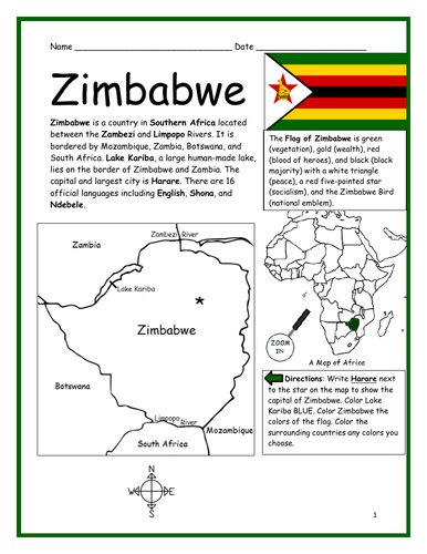
Introduce your students to ZIMBABWE in Africa with this printable handout of two worksheets (plus answer key). Your students will read a brief introduction to Zimbabwe (location, capital, flag, language), write ‘Harare’ next to the star on the map to show the capital, color the small map, and use the map and compass to answer 9 questions on page 2. Colored pencils and a pen or pencil are needed for this activity. No other prep needed. Basic Geography worksheet includes a simple map to introduce the country of Zimbabwe and practice cardinal/ordinal directions.
For use with Interactive Notebooks: After the worksheets are completed, students can cut out the map and flag and paste into the notebook under the topic of Africa/Sub-topic: Zimbabwe. Under the map and flag, your students can write a summary in their own words of what they now know about this country. Collect handouts for other countries of Africa to add to the notebook! Please browse this store for a selection of printable handouts for other countries of Africa (and beyond!).
Thank you so much for using my Geography worksheets in your classroom!
Included in resource: Lake Kariba, Zambezi River, Limpopo River, South Africa, Botswana, Zambia, Mozambique.
Resource Room
Introduce your students to LIBYA in Africa with two worksheets (plus answer key). Your students will read a brief introduction to Libya (location, capital, flag, language), write ‘Tripoli’ next to the star on the map to show the capital, color the small map, and use the map and compass to answer 9 questions on page 2. Colored pencils and a pen or pencil are needed for this activity. No other prep needed. Basic Geography worksheet with a simple map to introduce the country of Libya and practice cardinal/ordinal directions.
For use with Interactive Notebooks: After the worksheets are completed, students can cut out the map and flag and paste into the notebook under the topic of Africa/Sub-topic: Libya. Under the map and flag, your students can write a summary in their own words of what they now know about this country. Collect handouts for other countries of Africa to add to the notebook! Please browse this store for a selection of printable Geography worksheets for other countries of Africa (and beyond!)
Thank you so much for using my Geography worksheets in your classroom! I hope you find them useful.
Included on this map: Fezzan, Cyrenaica, Tripolitania, Mediterranean Sea, Egypt, Sudan, Chad, Niger, Algeria, Tunisia.
Introduce your students to SOMALIA in Africa with this printable handout of two worksheets (plus answer key). Your students will read a brief introduction to Somalia (location, capital, flag, language), write ‘Mogadishu’ next to the star on the map to show the capital, trace the line of the equator, color the small map, and use the map and compass to answer 9 questions on page 2. Colored pencils and a pen or pencil are needed for this activity. No other prep needed. Basic Geography worksheet includes a simple map to introduce Somalia and practice cardinal/ordinal directions.
For use with Interactive Notebooks: After the worksheets are completed, students can cut out the map and flag and paste into the notebook under the topic of Africa/Sub-topic: Somalia (or Horn of Africa). Under the map and flag, your students can write a summary in their own words of what they now know about this country. Collect handouts for other countries of Africa to add to the notebook! Please browse this store for a selection of printable handouts for other countries of Africa (and beyond!).
Thank you for using my Geography worksheets in your classroom! I hope you find them useful. Reviews are welcome and very much appreciated!
Included on map: Horn of Africa, Ethiopia, Djibouti, Kenya, Gulf of Aden, Somali Sea, Indian Ocean, Equator
Introduce your students to DJIBOUTI in Africa with this printable handout of two worksheets (plus answer key). Your students will read a brief introduction to Djibouti (location, capital, flag, language), write ‘Djibouti’ next to the star on the map to show the capital, color the small map, and use the map and compass to answer 8 questions on page 2. Colored pencils and a pen or pencil are needed for this activity. No other prep needed. Basic Geography worksheet includes a simple map to introduce Djibouti and practice cardinal/ordinal directions.
For use with Interactive Notebooks: After the worksheets are completed, students can cut out the map and flag and paste into the notebook under the topic of Africa/Sub-topic: Djibouti. Under the map and flag, your students can write a summary in their own words of what they now know about this country. Collect handouts for other countries of Africa to add to the notebook! Please browse this store for a selection of printable handouts for other countries of Africa (and beyond!).
Thank you so much for using my Geography worksheets in your classroom! I hope you find them useful. Reviews are welcome and very much appreciated!
Introduce your students to the Midwest region of the United States with this printable handout of one page (plus answer key). Using the map of the Midwest Region, find the twelve states in the word search puzzle: Iowa, Kansas, Missouri, Nebraska, North Dakota, South Dakota, Illinois, Indiana, Michigan, Minnesota, Ohio, Wisconsin.
Handouts for other 4 regions also available! Please check out this store for:
-SOUTHWEST REGION MAP AND WORD SEARCH
-NORTHEAST REGION MAP AND WORD SEARCH
-SOUTHEAST REGION MAP AND WORD SEARCH
-WEST REGION MAP AND WORD SEARCH
Thank you so much for using my Geography worksheets in your classroom!
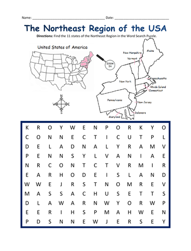
Introduce your students to the NORTHEAST REGION of the United States with this printable handout of one page (plus answer key). Using the map of the Northeast Region, find the eleven states in the word search puzzle: Connecticut, Maine, Massachusetts, New Hampshire, Rhode Island, Vermont, Delaware, Maryland, New Jersey, New York, Pennsylvania.
Other regions also available! Please browse this store for printable handouts for other regions of the United States and other Geography worksheets!
-SOUTHWEST REGION MAP AND WORD SEARCH
-MIDWEST REGION MAP AND WORD SEARCH
-SOUTHEAST REGION MAP AND WORD SEARCH
-WEST REGION MAP AND WORD SEARCH
Thank you so much for using my Geography worksheets in your classroom!
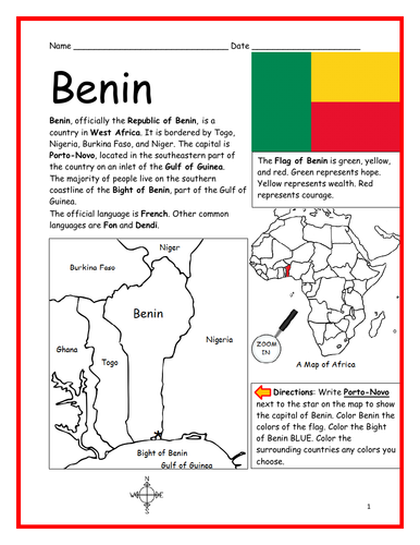
Introduce your students to the country of BENIN in Africa with this printable handout of two worksheets (plus answer key). Your students will read a brief overview of Benin (location, capital, flag, language), write ‘Porto-Novo’ next to the star on the map to show the capital, color the small map, and use the map and compass to answer 8 questions on page 2. Colored pencils and a pen or pencil are needed for this activity. No other prep needed. Basic Geography worksheet with a simple map to introduce the country of Benin and practice cardinal/ordinal directions.
For use with Interactive Notebooks: After the handout is completed, students can cut out the map and flag and paste into the notebook under the topic of Africa/Sub-topic: Benin. Under the map and flag, your students can write a summary in their own words of what they now know about this country. Collect handouts for other countries of Africa to add to the notebook! Please browse this store for a selection of printable handouts for other countries of Africa (and beyond!).
Thank you so much for using my Geography worksheets in your classroom!