Two lessons covering the first introductory lessons to Geography:<br />
<br />
L1: What is Geography? - introduction to geography and allows students to consider how geography is all around us.<br />
L2: Human & Physical Geography - introducing students to the differences between human, physical and environmental geography, before locating various human and physical features around the world.<br />
<br />
Challenge activities (in pink bubbles) have also been included in each lesson.<br />
<br />
Used with a new higher-ability Year 7 class, but can easily be adapted to fit other ages and abilities.<br />
<br />
Please rate my resources! Thank you :)
<p>Introduce your learners to Ireland with this printable handout of two worksheets (plus answer key). Your students will read a brief overview of Ireland (location, capital, flag, language), write ‘Dublin’ next to the star on the map to show the location of the capital, color the small map and flag, and use the map and compass to answer 6 multiple-choice questions on page 2. Colored pencils or and a pen or pencil are needed for this activity. No other prep needed. Basic Geography worksheet with a simple map to introduce the country of Ireland.</p>
<p>For use with Interactive Notebooks: After completing the worksheets, students can cut out the map and flag and paste it into the notebook under the topic of Europe / Sub-Topic: Ireland. Under the map, students will write a summary in their own words of what they now know about this country. Collect worksheets for other countries of Europe to add to the notebook! Please browse this store for a selection of worksheets for other countries of Europe (and beyond!).</p>
<p>Thank you so much for using my Geography worksheets in your classroom! I hope you find them useful. Reviews are welcome and very much appreciated.</p>
<p>Five complete lessons for KS1 Geography focused on Hot and Cold Places. The lessons include:</p>
<p>Lesson 1: To identify hot and cold places and locate them on a map.<br />
Lesson 2: To recognise the features of hot and cold places.<br />
Lesson 3: To identify animals that live in hot and cold places.<br />
Lesson 4: To pack a suitcase for a hot and cold country.<br />
Lesson 5: Hot and Cold Places Assessment.</p>
<p>This geography display features bold images of both human and physical features as outlined by the National Curriculum. Each A4 poster has a beautiful picture, title and short definition. These posters support pupils to associate the term with the visual representation and are great to reinforce learning. You can use them as a stand alone geography display or you can utilize the posters as they match up with your units of work.</p>
<p>Physical features include: beach, cliff, coast, forest, hill, mountain, sea,<br />
ocean, river, soil, valley, vegetation, season and weather</p>
<p>Human features include: city, town, village, factory, farm, house, office, port,<br />
harbour and shop</p>
<p>Included:<br />
24 posters (PDF)<br />
3 Headings (PDF): geography vocabulary, human features, physical features.</p>
<p>You might also be interested in:</p>
<p><a href="https://www.tes.com/teaching-resource/human-and-physical-features-clip-cards-12561052">https://www.tes.com/teaching-resource/human-and-physical-features-clip-cards-12561052</a></p>
<p><a href="https://www.tes.com/teaching-resource/construction-cards-human-and-physical-features-12569843">https://www.tes.com/teaching-resource/construction-cards-human-and-physical-features-12569843</a></p>
<p>If you like this resource, then please rate it and/or leave a comment.<br />
If the rate-resource button on this page does not work, then go to your ratings page by clicking <a href="https://www.tes.com/my-resources/reviews">https://www.tes.com/my-resources/reviews</a></p>
<p>This is a great activity pack to cover the Geography topic of ‘Our Local Area’ in KS1. There is an animated, interactive powerpoint created in a very child friendly format, to engage and inspire learning. Also included are I spy sheets, to encourage young children to look carefully around their local area to see what they can find. A checklist and some drawing activities and address writing. A lovely bundle of teaching resources to put the love back in learning.</p>
<p>Introduce your students to Nigeria with this printable handout of two worksheets (plus answer key). Your students will read a brief introduction to Nigeria (location, capital, flag, language), write ‘Abuja’ next to the star on the map to show the capital, color the small map, and use the map and compass to answer 8 questions on page 2. Colored pencils and a pen or pencil are needed for this activity. Basic Geography worksheet includes a simple map to introduce the country of Nigeria and practice cardinal/ordinal directions.</p>
<p>For use with Interactive Notebooks: After the worksheets are completed, students can cut out the map and flag and paste into the notebook under the topic of Africa / Sub-topic: Nigeria. Under the map and flag, your students can write a summary in their own words of what they now know about this country. Collect worksheets for other countries of Africa to add to the notebook! Please see this store for a selection of printable worksheets for other countries of Africa (and beyond!).</p>
<p>Thank you so much for using my Geography worksheets in your classroom! I hope you find them useful. Reviews are welcome and very much appreciated!</p>
<p>Introduce your students to GHANA in Africa with two worksheets (plus answer key). Your students will read a brief introductio to Ghana (location, capital, flag, language), write ‘Accra’ next to the star on the map to show the capital, color the small map, and use the map and compass to answer 9 questions on page 2. Colored pencils and a pen or pencil are needed for this activity. No other prep needed. Basic Geography worksheet with a simple map to introduce the country of Ghana and practice cardinal/ordinal directions.</p>
<p>For use with Interactive Notebooks: After the worksheets are completed, students can cut out the map and flag and paste into the notebook under the topic of Africa/Sub-topic: GHANA. Under the map and flag, your students can write a summary in their own words of what they now know about this country. Collect worksheets for other countries of Africa to add to the notebook! Please browse this store for a selection of printable handouts for other countries of Africa (and beyond!).</p>
<p>Thank you so much for using my Geography worksheets in your classroom!</p>
<p>The perfect geography and history unit focusing on Polar Explorers - completely ready to teach!</p>
<p>Each of the 6 lessons contains a highly detailed PowerPoint with all of the necessary subject knowledge presented in child-friendly terminology and an accompanying task. Where appropriate, simplified versions of the task are provided to enable differentiation.</p>
<p>With easy-to-follow lesson plans, this unit is an absolute time saver and will leave you feeling Ready To Teach!</p>
<p>Lesson 1 - locating the polar regions (geography)<br />
Lesson 2 - features of the polar regions (geography)<br />
Lesson 3 - the significance of Matthew Henson (history)<br />
Lesson 4 - expeditions in the past (history)<br />
Lesson 5 - the significance of Robert Scott and the Race to the South Pole (history)<br />
Lesson 6 - the significance of Felicity Aston (history)</p>
<p><em>Files now saved with Comic Sans font to reduce file size</em></p>
Ireland Lesson of the Western Europe series. Powerpoint presentation and 4-page worksheets about the human and physical geography involving size, borders, area, travel, capital city, population, climate, landmarks, currency and culture.
<p>Introduce your learners to AUSTRIA with two worksheets (plus answer key). Your students will read a brief introduction to Austria (location, capital, flag, language), write ‘Vienna’ next to the star on the map to show the location of the capital, color the small map and flag, and use the map and compass to answer 7 questions on page 2. Colored pencils and a pen or pencil are needed for this activity. No other prep needed. Basic Geography worksheet with a simple map to introduce Austria and practice cardinal and ordinal directions.</p>
<p>For use with Interactive Notebooks: After the worksheets are completed, students can cut out the map and flag and paste into the notebook under the topic of Europe / Sub-topic: Austria. Under the map, students can write a summary in their own words of what they now know about Austria. Collect worksheets for other countries of Europe to add to the notebook! All available in this store! Please browse this store for a selection of printable Geography worksheets for other countries of Europe (and beyond!).</p>
<p>Thank you for using my Geography worksheets in your classroom! I hope you find them useful. Reviews are welcome and very much appreciated!</p>
<p>German</p>
<p>Introduce your students to the country of LESOTHO in Africa with two worksheets (plus answer key). Your students will read a brief introduction to Lesotho (location, capital, flag, language), write ‘Maseru’ next to the star on the map to show the location of the capital, trace the line of the Caledon River, color the small map, and use the map and compass to answer 6 multiple-choice questions on page 2. Colored pencils and a pen or pencil are needed for this activity. No other prep needed. Basic Geography worksheet with a simple map to introduce the country of Lesotho.</p>
<p>For use with Interactive Notebooks: After the worksheets are completed, students can cut out the map and flag and paste into the notebook under the topic of Africa/Sub-topic: Lesotho. Under the map and flag, your students can write a summary in their own words of what they now know about this country. Collect worksheets for other countries of Africa to add to the notebook! Please browse this store for a selection of printable handouts for all other countries of Africa (and beyond!)</p>
<p>Thank you so much for using my Geography worksheets in your classroom! I hope you find them useful. Reviews are welcome and very much appreciated!</p>
<p>A lesson that focuses on being able to introduce the Americas.</p>
<p>Included in the lesson is:<br />
A lesson presentation that includes maps of North America and South America to discuss as well as some introductory information to the continents. This is finished off with some true or false questions.</p>
<p>A recap task (this lesson is the third in a sequence having focused on continents, oceans etc.) which can be used or ignored as the lesson can stand alone or if children have been taught about continents, Equator and hemisphere then they can complete this. An answer sheet is also included for the recap task.</p>
<p>An independent activity that includes identifying the two continents, true or false questions and sorting countries into which continent they are part of. There is also an extension task to then research and make notes on any country from either continent. An answer sheet is also included for this alongside a support sheet with maps of North and South America.</p>
<p>These interesting and highly-stimulating lessons enable students to develop an in-depth understanding of the physical and human geography features of the African continent. It culminates with them creating their very own African country geography study presentations. The scheme promotes engagement with varied geographical concepts including biomes, population, rivers, lakes, mountains, climate, borders and capital cities.</p>
<p>The lessons included are:<br />
1.African Overview - Facts and Key Information<br />
2.African Rivers and Lakes<br />
3.Country Study - Egypt (inc. Sahara Desert)<br />
4.Country Study - Kenya (inc. the Savanna)<br />
5.The Congo Rainforest<br />
6.Creating Country Studies</p>
<p>Each lesson contains eye-catching and comprehensive presentations, in addition to all of the worksheets and activity templates needed. Some of the lessons benefit from access to atlases and/or web-searching devices.</p>
<p>The scheme is most fitting for children across Key Stage 2.</p>
<p>The resources within this lesson can be easily adapted to suit home/remote learning.</p>
<p>Geography activities for year 1 and year 2. Teaching Power Point and print and go activities to teach The UK unit in KS1.<br />
**This product includes: ** Planning and resources for 2 weeks worth of lessons.<br />
A power point for each lesson, plus an end of lesson quiz.<br />
Printable activities for each lesson.<br />
<em>Lesson 1</em><br />
Name and locate the 7 continents and 5 oceans<br />
Choice of 4 worksheets<br />
<em>Lesson 2</em><br />
Name, locate and identify characteristics of the 4 UK countries and capital cities<br />
Activities - Colour UK Countries, label capital cities, label seas and oceans, UK landmarks cut and stick<br />
<em>Lesson 3</em><br />
Use basic geographical language<br />
Match words and pictures<br />
Label the locations<br />
Geographical questions<br />
<em>Lesson 4 and 5</em><br />
Identify physical and human features<br />
Local walk worksheet, Where I live, Draw a map, draw/label/sort physical and human features.<br />
<em>Lesson 6</em><br />
Use simple compass directions<br />
Label a map, directions, my school<br />
<em>Lesson 7</em><br />
Understand geographical differences and similarities<br />
Compare locations, compare countries,<br />
<em>Lesson 8</em><br />
Identify daily and seasonal weather patterns in the UK<br />
Daily weather charts<br />
Seasonal sorting<br />
<em>Lesson 9</em><br />
Identify hot and cold areas of the world<br />
Hot and cold climates of the world sorting<br />
<em>Lesson 10</em><br />
Assessment Quiz</p>
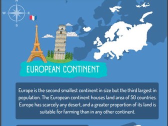
<p>Europe plan<br />
8 lesson plan that focuses on a range of topics related to Europe.<br />
Lesson 1 - What is Europe like?<br />
Lesson 2 - Countries in Europe<br />
Lesson 3 - Fact file on a country in Europe<br />
Lesson 4 - Capital cities<br />
Lesson 5 - Population and currency<br />
Lesson 6 - Temperature<br />
Lesson 7 - Mountains in Europe<br />
Lesson 8 - Landmarks (persuasive writing)<br />
Initially planned for Year 4 but could be adapted for other year groups.</p>
A map skills homework booklet for use with KS3 Geography classes.<br />
<br />
An amalgamation of worksheets I have gathered over the years to create a comprehensive and easy to mark Map Skills Homework Booklet!
Renewable and Non-Renewable Energy awareness with questions for discussion and answering.<br />
Cut and paste the water cycle (answer sheet included)<br />
Blank UK and World Map to create your own exercises.
Based around the question 'What is geography?', this display looks at geography from different viewpoints: politics, maths, history, writing, science etc to show why geography is important today!
 Quick View
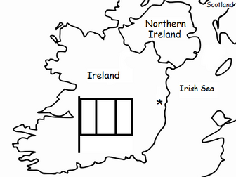 Quick View
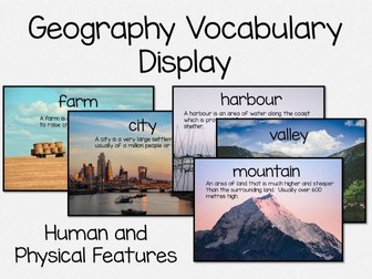 Quick View
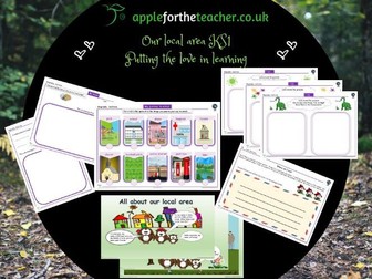 Quick View
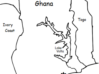 Quick View
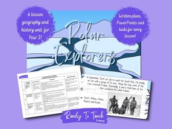 Quick View
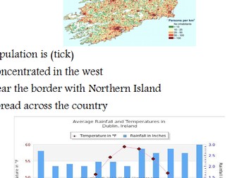 Quick View
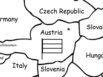 Quick View
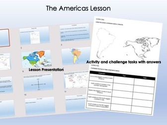 Quick View
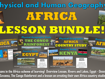 Quick View
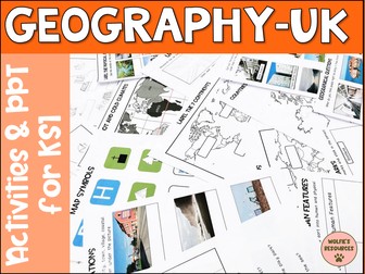 Quick View