Providing quality tested Geography resources at an affordable price. Take the stress out of your teaching and enjoy what many teachers joined the profession for, working with young people. Please follow & review to help me grow my store!
Providing quality tested Geography resources at an affordable price. Take the stress out of your teaching and enjoy what many teachers joined the profession for, working with young people. Please follow & review to help me grow my store!
In this 2 hour KS3 resource pupils contrast the quality of life in Ghana with that of the UK. Pupils are first taught how to describe the location of Ghana at various scales. Source analysis is used to stimulate discussion regarding living conditions within Ghana. Pupils read an interview of a girl living in Ghana and consider how her quality of life will be affected by her living conditions. The text is annotated with prompt questions to stimulate discussion and allow pupils to complete the worksheet activity. The learning is later assessed through a extended independent writing task. A writing frame is provided to guide pupils and improve structure.
**Bundle and save! This lesson is part of a larger bundle:- **
Development topic bundle
Check out some of my other products relating to weather and climate:-
What is development?
How can we measure development?
What are the causes of global inequality?
What is Africa like?
What are Africa’s climate zones?
How do squatter settlements affect peoples quality of life?
How can fair trade help to reduce the development gap?
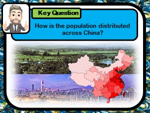
This 2 hour KS3 lesson teaches pupils to create and analyse choropleth maps. Pupils use population data to create distribution maps which they later describe and explain using satallite source images. Writing frames are provided to support and guide weaker learners as well as differentiated worksheets.
Check out some of my other products relating to China:-
Where is China?
What physical and human Geography exists across China?
What is rural to urban migration and why does it occur?
What are the problems of overpopulation?
How developed is China?
Was China’s one child policy an example of successful population control?
This** 2 hour KS3 lesson** teaches pupils about the key processes of the water cycle. The activities are designed to help pupils understand the sequencing of physical processes. A wide range of class exercises are provided and included: a card sort, diagram annotation, comic creation, a class game and extended independent creative writing task.
**Bundle and save! This lesson is part of a larger bundle:- **
Weather topic bundle
Check out some of my other products relating to weather and climate:-
What is the difference between weather and climate?
How can symbols be used to show weather patterns?
How can we describe weather patterns using weather symbols?
Is all rainfall produced in the same way?
Why does the UK experience the weather it does?
Why do floods occur and what are the effects?
This 1-2 hour KS3 resource investigates the factors influencing rural to urban migration in China. Pupils learn why individuals seek a better life in the city, and reflect on whether the grass is really greener. Students use a video case study to create a story board of one migrants experiences.
Check out some of my other products relating to China:-
Where is China?
What physical and human Geography exists across China?
How is the population distributed across China?
What are the problems of overpopulation?
How developed is China?
Was China’s one child policy an example of successful population control?
If you like my work, please follow me for more resources and leave a review!
This 2 hour KS3 lesson looks at how the damage from natural hazards can be reduced. A card-sort task is used to provide examples of prediction, protection and planning. A research task is used to look into how retrofitting and modern building techniques can reduce the chance of structural damage. An 8 mark exam question is included, with guidance and a basic writing frame for weaker pupils.
Bundle and save! This lesson is part of a larger bundle:-
Tectonic Hazards Topic Bundle
Check out some of my other products relating to Tectonic Hazards:-
What factors effect the risk from natural hazards?
What are the layers of the Earth?
What are tectonic plates?
Why are earthquakes and volcanoes found at plate boundaries?
What are earthquakes?
Are tsunamis the deadliest natural hazard?
Why live in tectonically active regions?
How can hazard risk be mitigated?
If you like my work, please follow me for more resources and leave a review!
This 2 hour KS3 lesson teaches students about the hazards of ocean plastic. Pupils develop their analytical skills, using a line graph to describe the ever increasing production of plastic products. Pupils reflect on how plastic is disposed of, and consider if recycling is really as effective as governments make out. A heads and tails exercise teaches pupils about the impact of ocean plastic, encouraging pupils to elaborate and develop their ideas. Pupils are asked to decide for themselves if enough is being done to tackle this global issue.
Bundle and save! This lesson is part of a larger bundle:-
India & The Plastic Problem
Check out some of my other products relating to India & The Plastic Problem:-
Why is plastic hazardous?
Where is India and what is it like?
How does India’s physical Geography influence the location of its major cities?
Why does India have a monsoon climate?
How do ocean gyres move plastic pollution?
How developed is India?
Why does India have so many squatter settlements?
What are the impacts of marine plastic waste?
How can plastic waste be reduced?
If you like my work, please follow me for more resources and leave a review!
This 1-2 hour KS3 lesson teaches pupils to use map symbols. Students are initially required to try to identify potential map symbols on an OS image. Understanding is developed through a mix and match task, followed by a fun kinaesthetic ‘pairs’ style activity. Students finally design their own treasure map, being required to write a descriptive paragraph to guide their partner to the buried treasure!
Bundle and save! This lesson is part of a larger bundle:-
Geographical skills topic bundle
Check out some of my other products relating to Geographical skills:-
Where are the major oceans, countries, continents, rivers and mountains?
How can we use a compass?
What are lines of latitude and longitude?
How can we use 4 & 6 figure grid references?
How is height represented on a map?
How can we measure distance using maps?
If you like my work, please follow me for more resources and leave a review!
This 3 hour KS3 lesson investigates the formation of the universe. Pupils try to appreciate the shear scale of the universe, learning the difference between solar systems and galaxies. Students are provided with two comic strips, which they must arrange into the correct sequence. One outlines the formation of the universe itself and the other planets like Earth. The lesson includes a independent writing tasks, with supporting writing frames. A video resource and respective question sheet is also provided.
Bundle and save! This lesson is part of a larger bundle:-
Earth’s Story topic bundle
Check out some of my other products relating to Earth’s history:-
What is evolution?
How did life on Earth evolve?
What killed the dinosaurs?
If you like my work, please follow me for more resources and leave a review!
This 2 hour KS3 resource looks at both 4 and 6 figure grid referencing. Clean instructional slides are provided on how to demonstrate such skills. Two respective worksheets are provided as well as some whole class tasks.
Bundle and save! This lesson is part of a larger bundle:-
Geographical skills topic bundle
Check out some of my other products relating to Geographical skills:-
Where are the major oceans, countries, continents, rivers and mountains?
How can we use a compass?
What are lines of latitude and longitude?
Why are map symbols useful?
How is height represented on a map?
How can we measure distance using maps?
If you like my work, please follow me for more resources and leave a review!
This 1 hour KS3 lesson teaches pupils about the various types of tourism. Students first discover what separates tourism from travel. Pupils are required to organise a holiday package for different customer types, before justifying why each aspect of the holiday has been selected for their chosen customer. A mix and match card sort is used to teach students about the vast range of tourism opportunities and environments.
Bundle and save! This lesson is part of a larger bundle:-
Tourism topic bundle
Check out some of my other products relating to Tourism:-
Why has the tourism industry grown?
Why do coasts, mountains and cities attract visitors?
How do glaciers shape the landscape?
What are the features of a glaciated landscape?
Why does conflict exist in national parks?
How can conflict in national parks be managed?
Where is the Amazon Rainforests & what is it like?
Why is the Amazon Rainforests under threat?
How can eco-tourism help to manage rainforests sustainably?
Why do tourists visit extreme environments?
How does tourism impact Antarctica?
If you like my work, please follow me for more resources and leave a review!
In this** 2 hour KS3 lesson**, pupils investigate extreme tourism in Antarctica. Students watch a video clip to understand why tourists visit this extreme but beautiful continent. Source images are used to teach pupils about the conflicts caused by tourists. A card sort activity is included in which pupils categorise the positive and negative impacts of tourism. Students are taught about the strategies being use to make Antarctica tourism more sustainable.
Bundle and save! This lesson is part of a larger bundle:-
Tourism topic bundle
Check out some of my other products relating to Tourism:-
What types of tourism exist?
Why has the tourism industry grown?
Why do coasts, mountains and cities attract visitors?
How do glaciers shape the landscape?
What are the features of a glaciated landscape?
Why does conflict exist in national parks?
How can conflict in national parks be managed?
Where is the Amazon Rainforests & what is it like?
Why is the Amazon Rainforests under threat?
How can eco-tourism help to manage rainforests sustainably?
Why do tourists visit extreme environments?
How does tourism impact Antarctica?
If you like my work, please follow me for more resources and leave a review!
This 1 hour KS3 lesson focuses on extreme tourism in Antarctica. Students reflect on the rational for undertaking such a trip and consider the appeal of extreme destinations. The lesson includes a link to an Antarctica interactive quiz. Pupils listen to the sounds of Antarctica, helping to students to visualise visiting this isolated area. Pupils then complete a piece of creative writing using source images and supporting word bank. A mapping task is included to improving locational knowledge.
Bundle and save! This lesson is part of a larger bundle:-
Tourism topic bundle
Check out some of my other products relating to Tourism:-
What types of tourism exist?
Why has the tourism industry grown?
Why do coasts, mountains and cities attract visitors?
How do glaciers shape the land?
What are the features of a glaciated landscape?
Why does conflict exist in national parks?
How can conflict in national parks be managed?
Where is the Amazon Rainforests & what is it like?
Why is the Amazon Rainforests under threat?
How can eco-tourism help to manage rainforests sustainably?
How does tourism impact Antarctica?
If you like my work, please follow me for more resources and leave a review!
This 1-2 hour lesson teaches pupils about the sensitive nature of food webs. Students first engage in an interactive task in which they must create their own food web using cards and other members of the class. Once the food chain has been ‘found’ they answer questions about their said chain. Pupils then reflect on the difference between a food chain and a food web. Students are taught how energy flows through a food web, before adding arrows to a example, representing predator pray relationships. In the final tasks the idea of interdependence is introduced. Here pupils are required to explain the impact of various changes to a food web.
Workbook pintables are provided which follow the PowerPoint lesson. Multiple choice checking for understanding slides are included, as well as links and videos to allow pupils to secure their learning at home.
Bundle and save! This lesson is part of a larger bundle:-
Rainforest ecosystems
Check out some of my other products relating to Rainforests & Ecosystems:-
What is a food chain?
What are the major biomes?
What are rainforests like?
How do animal and plants adapt to the rainforest?
Why does deforestation occur in tropical rainforests?
Why has deforestation occurred in Malaysia?
How can deforestation be managed sustainably?
If you like my work, please follow me for more resources and leave a review!
This 2-3 hour lesson teaches pupils about the importance of the rainforest. Students learn why tropical forests are being removed, despite them being such a precious resource both locally and globally. In the first task pupils use dual coding to mind map and categorise the importance of the forest. Satellite images are used to highlight global forest loss hot spots. Students then improve their numerical skills by comparing forest loss of the Brazilian and Non-Brazilian Amazon. A writing frame is provided here to support weaker pupils. Source images are used to stimulate discussion, as to why forest is being removed. Pupils then undertake a guided reading exercise, before finally completing a card sort task.
Workbook pintables are provided which follow the PowerPoint lesson. Multiple choice checking for understanding slides are included, as well as links and videos to allow pupils to secure their learning at home.
Bundle and save! This lesson is part of a larger bundle:-
Rainforest ecosystems
Check out some of my other products relating to Rainforests & Ecosystems:-
What is a food chain?
What are food webs?
What are the major biomes?
What are rainforests like?
How do animal and plants adapt to the rainforest?
Why has deforestation occurred in Malaysia?
How can deforestation be managed sustainably?
This 1-2 hour lesson investigates the concept of development. Pupils describe the location of countries of contrasting development, and learn to identify global patterns. A game activity is used to reinforce key geographical terms and a writing frame is provided for the written task.
**Bundle and save! This lesson is part of a larger bundle:- **
Development topic bundle
Check out some of my other products relating to weather and climate:-
How can we measure development?
What are the causes of global inequality?
What is Africa like?
What are Africa’s climate zones?
How do squatter settlements affect peoples quality of life?
How does quality of life differ between HIC & LIC countries?
How can fair trade help to reduce the development gap?
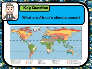
In this 2-3 hour KS3 lesson, pupils will learn about Africa’s diverse climate and physical environment. Students are introduced to the various biomes that exist across the African continent and learn how animals and plants adapt to the harsh conditions. Geographical skills are developed within the lesson as pupils analyse the climate graphs of four contrasting biomes.
**Bundle and save! This lesson is part of a larger bundle:- **
Development topic bundle
Check out some of my other products relating to weather and climate:-
What is development?
How can we measure development?
What are the causes of global inequality?
What is Africa like?
How do squatter settlements affect peoples quality of life?
How does quality of life differ between HIC & LIC countries?
How can fair trade help to reduce the development gap?
If you like my work, please follow me for more resources and leave a review!
This** 2 hour KS3 lesson** explores rainforest environments. Pupils learn to describe the locations of such environments and learn the reasons for their global distribution. Pupils analyse source images and use a sense wheel to imagine themselves in such an environment. Students improve Geographical skills, being taught to use a climate graph to describe Brazil’s climatic conditions.
Bundle and save! This lesson is part of a larger bundle:-
Tourism topic bundle
Check out some of my other products relating to Tourism:-
What types of tourism exist?
Why has the tourism industry grown?
Why do coasts, mountains and cities attract visitors?
How do glaciers shape the land?
What are the features of a glaciated landscape?
Why does conflict exist in national parks?
How can conflict in national parks be managed?
Why is the Amazon Rainforests under threat?
How can eco-tourism help to manage rainforests sustainably?
Why do tourists visit extreme environments?
How does tourism impact Antarctica?
This 1-2 hour KS3 lesson investigates the strategies used to manage tourism in national parks sustainably. The lesson uses the UK’s Lake District national park as a case study. Students use information cards to fill in a table overviewing the advantages, disadvantages and relative sustainability of seven different approaches.
Bundle and save! This lesson is part of a larger bundle:-
Tourism topic bundle
Check out some of my other products relating to Tourism:-
What types of tourism exist?
Why has the tourism industry grown?
Why do coasts, mountains and cities attract visitors?
How do glaciers shape the land?
What are the features of a glaciated landscape?
Why does conflict exist in national parks?
Where is the Amazon Rainforests & what is it like?
Why is the Amazon Rainforests under threat?
How can eco-tourism help to manage rainforests sustainably?
Why do tourists visit extreme environments?
How does tourism impact Antarctica?
If you like my work, please follow me for more resources and leave a review!
This three hour KS3 lesson investigates the impact of glaciers on the physical landscape. Pupils learn how ice changes the shape of mountain valleys over time, using key terms to describe the features of such landscapes. The lesson includes a worksheet that guides pupils through the transition of ‘V’ and ‘U’ shaped valleys. Students then identify glacial features on a source image, using written descriptions. Pupils finally undertake a ‘carousel’ style exercise, collecting information about: corries, aretes, pyramidal peaks, glacial troughs, hanging valleys an ribbon lakes. Supporting worksheets included.
Bundle and save! This lesson is part of a larger bundle:-
Tourism topic bundle
Check out some of my other products relating to Tourism:-
What types of tourism exist?
Why has the tourism industry grown?
Why do coasts, mountains and cities attract visitors?
How do glaciers shape the land?
Why does conflict exist in national parks?
How can conflict in national parks be managed?
Where is the Amazon Rainforests & what is it like?
Why is the Amazon Rainforests under threat?
How can eco-tourism help to manage rainforests sustainably?
Why do tourists visit extreme environments?
How does tourism impact Antarctica?
If you like my work, please follow me for more resources and leave a review!
This 1 hour KS3 lesson investigates the features that attract people to both human and physical landscapes. Students use source images to consider the unique characteristics of coastal, mountainous and urban destinations. Pupils then complete their worksheet, which overviews the features of each area. Students are taught the difference between labels and annotates, and are required to select one area to work on independently. Exemplars and answer sheet included.
Bundle and save! This lesson is part of a larger bundle:-
Tourism topic bundle
Check out some of my other products relating to Tourism:-
What types of tourism exist?
Why has the tourism industry grown?
How do glaciers shape the land?
What are the features of a glaciated landscape?
Why does conflict exist in national parks?
How can conflict in national parks be managed?
Where is the Amazon Rainforests & what is it like?
Why is the Amazon Rainforests under threat?
How can eco-tourism help to manage rainforests sustainably?
Why do tourists visit extreme environments?
How does tourism impact Antarctica?