I've worked in primary teaching for over 10 years and specialise in creating fun and engaging educational resources, particularly for Geography and History.
I've worked in primary teaching for over 10 years and specialise in creating fun and engaging educational resources, particularly for Geography and History.
This lesson is designed for KS2 children. It can be taught as a stand alone lesson but is also available as part of two wider units, both of which are available on TES:
-Earthquakes
-Volcanoes & Earthquakes
First the presentation looks at how the Earth’s crust is split into tectonic plates. It then examines the causes of earthquakes, how they occur at the fault lines between tectonic plates and what the hypocentre and epicentre of an earthquake are.
There are three different activities to choose from which can be done in Geography and/or Literacy lessons. These include:
Quiz Activity
Students watch a video clip about earthquakes and answer comprehension questions about it. This is differentiated two ways.
Cloze Procedure Activity
Students fill in the blanks in an explanation text about earthquakes. This is differentiated two ways.
Writing Activity
Student write an explanation text about earthquakes. This is differentiated three ways and comes with vocabulary and sentence starter prompts.
If you like this resource, we would appreciate a review! We will happily send you a free resource in return for a review or useful suggestions/feedback. Contact us at ed@teachitforward.co.uk.
This lesson is designed for KS2 students. It can be taught as a stand alone lesson but is also available as part of three wider units, all of which are available on TES:
-Volcanoes
-Earthquakes
-Volcanoes & Earthquakes
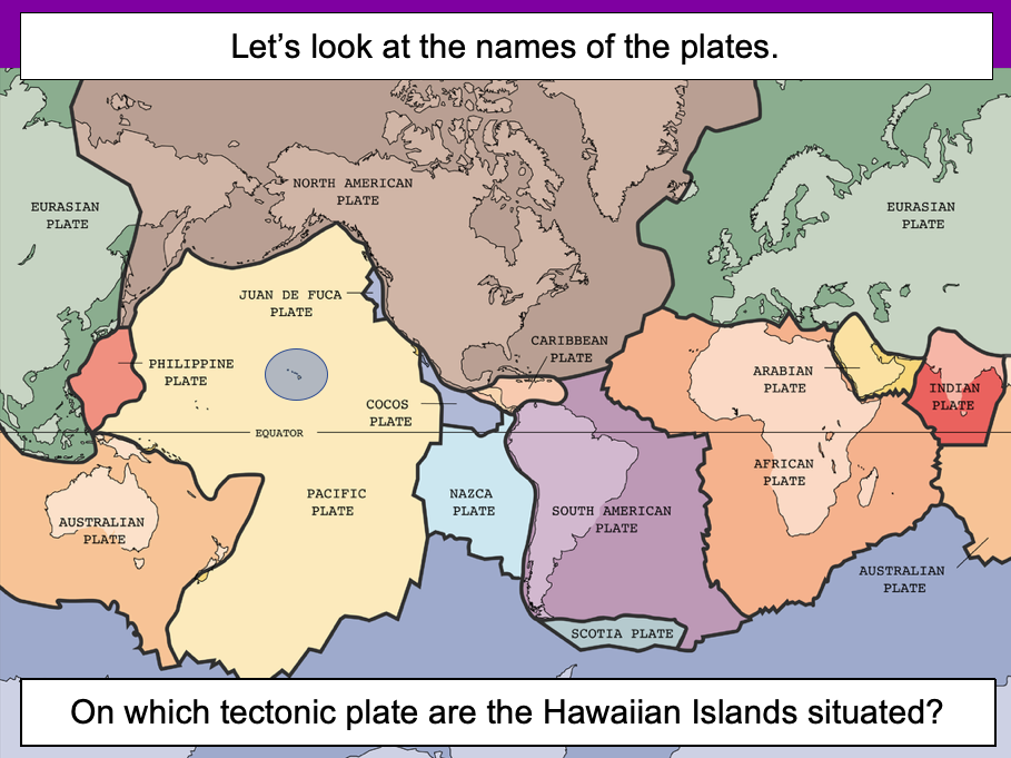
The presentation introduces the idea that the world’s crust is split into tectonic plates and looks at how these are related to volcanoes and earthquakes.
The activity challenges students to identify tectonic plates using a map. It is differentiated two ways:
Easier – Students identify the world’s tectonic plates using a colour-coordinated map.
Harder – Students identify the world’s tectonic plates using a plain map.
Extension – Students use an atlas to find out which tectonic plate countries of the world are located on.
If you like this resource, we would appreciate a review! We will happily send you a free resource in return for a review or useful suggestions/feedback. Contact us at ed@teachitforward.co.uk.
This lesson is designed for KS2 students and is a great introduction to any volcanoes or earthquakes topic. It can be taught as a stand alone lesson but is also available as part of three wider units, all of which are available on TES:
-Volcanoes
-Earthquakes
-Volcanoes & Earthquakes
The presentation investigates the structure of the Earth and looks into the basic composition of the inner core, outer core, mantle and crust.
Students then complete an activity which is differentiated three ways:
Easier – Students label layers of the Earth and complete cloze procedure paragraph (6 gaps).
Medium – Students label layers of the Earth and complete cloze procedure paragraph (10 gaps).
Harder – Students label layers of the Earth – including drawing arrows – and complete cloze procedure paragraph (10 gaps).
Extension – Students think about what they would like to find out about volcanoes or earthquakes or both, depending on which topic you are doing.
If you like this resource, we would appreciate a review! We will happily send you a free resource in return for a review or useful suggestions/feedback. Contact us at ed@teachitforward.co.uk.
This lesson is an ideal introduction to the world’s three main climate zones.
It is part of Our World, a Geography unit designed for students in KS1 and lower KS2 (Y1-3), but can also be taught as a stand alone lesson.
First the presentation helps students understand that different places in the world have different climates. It then looks at the location of the Equator and North/South poles, and how these relate to the three main climate zones. To keep things simple, these are referred to as hot (tropical), mild (temperate) and cold (frigid).
The activity challenges students to locate the Equator and poles and then identify various climate zones around the world. It is differentiated two ways:
Easier – Students identify the climate zone of 8 numbered points around the world.
Harder – Students identify climate zone and continent of 8 numbered points around the world.
Extension – Students cut and stick pictures of four animals – elephant, lion, polar bear and penguin – onto their world climate zone map.
If you like this resource, we would appreciate a review! We will happily send you a free resource in return for a review or useful suggestions/feedback. Contact us at ed@teachitforward.co.uk.
This lesson is part of Understanding Trade, a Geography unit designed for students in upper KS2 (Y5-6).
The presentation starts by recapping what imports and exports are. It goes on to look at the UK’s top ten exports – mainly manufactured products – and the human and physical factors which help UK exports in this area.
In the activity, students use Microsoft PowerPoint to create a table of the UK’s top ten exports. They then use an online chart maker to produce either a pie chart or bar graph to illustrate this data. It is differentiated three ways:
Easier – Students use step-by-step instructions with some data already filled in
Medium – Students use step-by-step instructions
Harder – Minimal instructions – IT experts only!
If you like this resource, we would appreciate a review! We will happily send you a free resource in return for a review or useful suggestions/feedback. Contact us at ed@teachitforward.co.uk.
This lesson is part of Exploring the United Kingdom, a Geography unit designed for KS1 and lower KS2 (Y2-4).
The presentation helps students understand the difference between human and physical geographical features. It then challenges them to classify famous UK landmarks as either human or physical.
There are two engaging activities included:
Partner activity:
Students sort pictures/descriptions of UK landmarks into human and physical geographical features.
Individual activity:
Students match pictures of UK landmarks to their descriptions. This is differentiated three ways:
Easier – Students match 8 features to their descriptions.
Medium – Students match 12 features to their descriptions.
Harder – Students write a description of each UK landmark using a word bank.
Extension – Students sort the UK landmarks into human and physical geographical features.
If you like this resource, we would appreciate a review! We will happily send you a free resource in return for a review or useful suggestions/feedback. Contact us at ed@teachitforward.co.uk.
This lesson is part of Understanding Latitude and Longitude, a unit designed for students in upper KS2 and KS3. It can also be taught as a stand-alone lesson.
The presentation introduces the concept of lines of latitude and longitude, including the Equator and Prime Meridian, and goes on to explain their purpose and relationship to Earth’s hemispheres and poles.
In the activity, students have to identify all of these features on diagrams of the Earth. It is differentiated two ways and includes an extension:
Easier – Students have label clues and a vocabulary bank to help them.
Harder – Students have only a vocabulary bank to help them.
Extension – Students fill in the missing words in a text about latitude and longitude.
If you like this resource, we would appreciate a review! We will happily send you a free resource in return for a review or useful suggestions/feedback. Contact us at ed@teachitforward.co.uk.
This lesson is designed for KS2 children. It can be taught as a stand alone lesson but is also available as part of two wider units, both of which are available on TES:
-Earthquakes
-Volcanoes & Earthquakes
The presentation looks at three famous earthquakes from the previous decade including Haiti (2010), New Zealand (2011) and Japan (2011).
The activity then challenges students to research an earthquake online (e.g. Simple Wikipedia) and write a fact file about it. A completed fact file about the earthquake in Christchurch in 2011 is included as an example.
Easier – Students research and create a fact file about their chosen earthquake.
Harder – Students research and create a fact file about their chosen earthquake plus insert a map and add photo captions.
If you like this resource, we would appreciate a review! We will happily send you a free resource in return for a review or useful suggestions/feedback. Contact us at ed@teachitforward.co.uk.
This lesson is designed for KS2 children. It can be taught as a stand alone lesson but is also available as part of two wider units, both of which are available on TES:
-Earthquakes
-Volcanoes & Earthquakes
N.B. Ideally children have a grounding in latitude and longitude prior to this lesson. The unit Understanding Latitude & Longitude is an ideal introduction to the topic.
First the presentation introduces students to latitude and longitude and goes through how to find the coordinates of a point step-by-step. It then asks them to find the latitude and longitude of several world capital cities.
The activity challenges students to locate the world’s biggest earthquakes using their latitude and longitude. It is differentiated three ways:
Easier – Students locate 12 earthquakes using latitude and longitude.
Medium – Students locate 15 earthquakes using latitude and longitude.
Harder – Students locate 18 earthquakes using latitude and longitude.
If you like this resource, we would appreciate a review! We will happily send you a free resource in return for a review or useful suggestions/feedback. Contact us at ed@teachitforward.co.uk.
This lesson is part of Mountain Environments, a Geography unit designed for students in upper KS2 (Y4-6).
First the presentation introduces some of the most famous mountain ranges from around the world.
The differentiated activity then challenges students to locate the world’s mountain ranges and encourages them to use and explore atlases. It is recommended that students do the activity in pairs.
Easier – Students identify the world’s famous mountain ranges (less writing).
Medium – Students identify the world’s famous mountain ranges (first letter clues)
Harder – Students identify the world’s famous mountain ranges (no clues)
If you like this resource, we would appreciate a review! We will happily send you a free resource in return for a review or useful suggestions/feedback. Contact us at ed@teachitforward.co.uk.
This lesson is designed for KS2 children. It can be taught as a stand alone lesson but is also available as part of two wider units, both of which are available on TES:
-Earthquakes
-Volcanoes & Earthquakes
The presentation investigates the five deadly features of earthquakes including ground shaking, tsunamis, landslides, raising/lowering of land and liquefaction.
It is followed up by an activity which is differentiated four ways:
Easier – Students match pictures of the five features of an earthquake to descriptions.
Medium – Students complete cloze procedure sentences. They then match pictures to each description.
Harder – Students complete cloze procedure sentences. They then match pictures to each description and add a title for each section.
Hardest – Students stick pictures of the five features of an earthquake in their books and write their own description next to each one.
Extension – Can students unscramble the jumbled up earthquake facts?
If you like this resource, we would appreciate a review! We will happily send you a free resource in return for a review or useful suggestions/feedback. Contact us at ed@teachitforward.co.uk.
This lesson is part of Understanding Latitude and Longitude, a unit designed for students in upper KS2 and KS3. It can also be taught as a stand-alone lesson.
This lesson explains step-by-step how to find the coordinates of a point on a world map using lines of latitude and longitude.
In the activity, students are challenged to find the latitude and longitude of 12 points in all four quadrants of a world map. It is differentiated three ways:
Easier – Students find coordinates of 12 points in the NE, SE, SW and NW quadrants of the world map respectively. The compass directions are already filled in.
Medium – Students find coordinates of 12 points in the NE, SE, SW and NW quadrants of the world map respectively.
Harder – Students find coordinates of 12 points randomly distributed across the four quadrants of the world map.
Extension – Students are challenged to draw and label 4 more points on to their map.
If you like this resource, we would appreciate a review! We will happily send you a free resource in return for a review or useful suggestions/feedback. Contact us at ed@teachitforward.co.uk.
This lesson is part of Understanding Trade, a Geography unit designed for students in upper KS2 (Y5-6).
First the presentation helps students understand what trade is and introduces the concepts of imports and exports. It does this by linking these ideas to every day products we buy. It also looks at the different scales of trade – local, national and international.
The activity then challenges students to match up products with statements about the company which makes them and where they are produced/manufactured.
Easier – Match the products to the statements (on stickers)
Harder – Match the products to the statements (written)
Extension – Students complete a cloze procedure paragraph about trade.
If you like this resource, we would appreciate a review! We will happily send you a free resource in return for a review or useful suggestions/feedback. Contact us at ed@teachitforward.co.uk.
This lesson is designed for KS2 students. It can be taught as a stand alone lesson but is also available as part of two wider units, both of which are available on TES:
-Volcanoes
-Volcanoes & Earthquakes
First the presentation looks at Mount Etna and Mount Vesuvius in Italy and asks why people choose to live so close to volcanoes.
The activities then challenges students to think about the advantages and disadvantages of living near a volcano:
Partner Activity:
Students sort statements and photos into advantages and disadvantages of living near a volcano.
Writing Activity:
Students write about the advantages and disadvantages of living near a volcano. Stickers and a vocabulary prompt are provided for this activity.
If you like this resource, we would appreciate a review! We will happily send you a free resource in return for a review or useful suggestions/feedback. Contact us at ed@teachitforward.co.uk.
This lesson is part of Exploring Brazil, a Geography unit designed for students in KS2 (Y4-6), but can also be taught as a stand alone lesson.
It takes students on a tour of the geographical features of Brazil. First students investigate a satellite photo of South America. They then look at a map of Brazil itself to see what human and physical features they can spot (e.g. Brazilian cities, Amazon rainforest).
In the activity students identify human and physical features of Brazil. It is differentiated three ways:
Easier – Students label 10 physical features of Brazil.
Medium – Students draw in arrows and label 10 physical features of Brazil.
Harder – Students stick a map of Brazil into their book, draw in arrows and label 10 physical features.
Extension – Students use atlases to also identify 8 Brazilian cities.
If you like this resource, we would appreciate a review! We will happily send you a free resource in return for a review or useful suggestions/feedback. Contact us at ed@teachitforward.co.uk.
This lesson is part of Understanding Trade, a Geography unit designed for students in upper KS2 (Y5-6).
The presentation first asks students to think about how the products we buy arrive in the shops. It then introduces the concept of supply chains. To explain this concept, students look at the processes involved in the production of milk.
There are two activities:
Group Activity:
Students sort and sequence four mixed up supply chains including those of bananas, T-shirts, bookshelves and coffee.
Individual Activity:
Students sequence the supply chains of bananas, T-shirts, bookshelves and coffee.
Easier – Students sequence supply chains (first and last process given)
Harder – Students sequence supply chains (no clues)
If you like this resource, we would appreciate a review! We will happily send you a free resource in return for a review or useful suggestions/feedback. Contact us at ed@teachitforward.co.uk.
This lesson is part of Mountain Environments, a Geography unit designed for students in upper KS2 (Y4-6).
First the presentation looks at features of a mountain climate including lower temperatures and increased rainfall. It then focuses in more detail on the climate of Mount Everest.
There are two activities:
Interpreting climate graphs
In this activity students look at and answer questions about temperature graphs for both the summit and base camp of Mount Everest. It is differentiated two ways:
Easier – Students answer questions about temperature graphs for Mount Everest (suitable for Year 4 and 5).
Harder – Students answer questions about temperature graphs for Mount Everest (suitable for Year 6).
Creating a climate graph in Excel
In this ICT activity, students create their own climate graph, including temperature and rainfall, for the summit of Mount Everest using Microsoft Excel.
If you like this resource, we would appreciate a review! We will happily send you a free resource in return for a review or useful suggestions/feedback. Contact us at ed@teachitforward.co.uk.
This lesson is part of Exploring Brazil, a Geography unit designed for students in KS2 (Y4-6), but can also be taught as a stand alone lesson.
It is a great introduction to using 6-figure grid references. The presentation first recaps how to find 4-figure grid references, then demonstrates how to find 6-figure grid references step by step.
There are two activities:
Activity 1:
Students locate 16 Brazilian cities using 4-figure grid references.
Extension – Students answer questions involving grid references and compass directions.
Activity 2:
Students have a go at describing the location of Brazilian cities more precisely using 6-figure grid references.
Easier – Students use mini-grids to help them locate 16 cities using 6-figure grid references.
Medium – Students use mini-grids to locate 8 cities, then estimate 6-figure grid references for 8 more cities.
Harder – Students have to estimate 6-figure grid references for all 16 cities (i.e. no mini-grids).
If you like this resource, we would appreciate a review! We will happily send you a free resource in return for a review or useful suggestions/feedback. Contact us at ed@teachitforward.co.uk.
This lesson is designed for KS2 children. It can be taught as a stand alone lesson but is also available as part of two wider units, both of which are available on TES:
-Earthquakes
-Volcanoes & Earthquakes
The presentation first asks students how they would go about finding information about earthquakes. It then introduces them to the online encyclopedia Wikipedia.
The activity then challenges students to research the world’s 12 biggest earthquakes:
Easier – Students use Wikipedia to find one piece of information per earthquake.
Harder – Students use Wikipedia to find two pieces of information per earthquake.
Extension – Students answer questions about the world’s famous earthquakes using Wikipedia.
If you like this resource, we would appreciate a review! We will happily send you a free resource in return for a review or useful suggestions/feedback. Contact us at ed@teachitforward.co.uk.
This lesson is part of Exploring Brazil, a Geography unit designed for students in KS2 (Y4-6), but can also be taught as a stand alone lesson.
The presentation first locates Brazil in the world’s climate zones and asks children to infer what the country’s weather and climate might be like.
Next, students look at three areas of Brazil in more detail – Manaus in the Amazon, Teresina in the caatinga desert region and Porto Alegre in the south of the country – and investigate a climate graph.
There are two activities:
Activity 1:
Students first investigate three climate graphs, looking at temperature and rainfall. Their challenge is to match each graph to an area of Brazil, explaining their reasoning for their choices. It is differentiated 2 ways:
Easier – Students match two statements to each climate graph, then match each graph to one of the three cities/regions.
Harder – Students write sentence describing the temperature and rainfall patterns in each climate graph, then match each graph to one of the three cities/regions.
Activity 2:
Students create their own Brazil climate graphs in Microsoft Excel using step-by-step instructions.
If you like this resource, we would appreciate a review! We will happily send you a free resource in return for a review or useful suggestions/feedback. Contact us at ed@teachitforward.co.uk.