I've worked in primary teaching for over 10 years and specialise in creating fun and engaging educational resources, particularly for Geography and History.
I've worked in primary teaching for over 10 years and specialise in creating fun and engaging educational resources, particularly for Geography and History.
This lesson is designed for KS2 students. It can be taught as a stand alone lesson but is also available as part of three wider units which are available on TES:
Volcanoes
Volcanoes & Earthquakes
Mountain Environments
First the presentation looks at the features of a volcano, how they are formed and the causes of volcanic eruptions. In the activity, which is differentiated three ways, students identify ten features of a volcano.
Easier – Students identify ten features of a volcano (with prompt boxes and arrows).
Medium – Students identify ten features of a volcano (no prompt boxes or arrows).
Harder – Students identify ten features of a volcano and write a sentence explanation for each one.
Extension – Children complete a cloze procedure activity (differentiated two ways).
If you like this resource, we would appreciate a review! We will happily send you a free resource in return for a review or useful suggestions/feedback. Contact us at ed@teachitforward.co.uk.
This is the free planning overview for Volcanoes. A vocabulary page and topic title page are also included.
The unit is designed for KS2 students and includes seven fully-planned lessons complete with differentiated activities and worksheets.
All the resources described in this unit plan are available on TES, either as individual lessons or as a bundle. Lessons include:
L1 – Understanding the structure of the Earth
L2 – Investigating the structure of a volcano
L3 – Locating the world’s famous volcanoes
L4 – Investigating the five deadly features of a volcanic eruption
L5 – Understanding tectonic plates
L6 – Exploring the effects of volcanic eruptions on Montserrat
L7 – Why do people live near volcanoes?
A free newspaper report template is also included in this unit.
If you like this resource, we would appreciate a review! We will happily send you a free resource in return for a review or useful suggestions/feedback. Contact us at ed@teachitforward.co.uk.
This lesson is designed for KS2 students. It can be taught as a stand alone lesson but is also available as part of two wider units, both of which are available on TES:
-Volcanoes
-Volcanoes & Earthquakes
First the presentation looks at Mount Etna and Mount Vesuvius in Italy and asks why people choose to live so close to volcanoes.
The activities then challenges students to think about the advantages and disadvantages of living near a volcano:
Partner Activity:
Students sort statements and photos into advantages and disadvantages of living near a volcano.
Writing Activity:
Students write about the advantages and disadvantages of living near a volcano. Stickers and a vocabulary prompt are provided for this activity.
If you like this resource, we would appreciate a review! We will happily send you a free resource in return for a review or useful suggestions/feedback. Contact us at ed@teachitforward.co.uk.
This lesson is designed for KS2 students. It can be taught as a stand alone lesson but is also available as part of two wider units, both of which are available on TES:
-Volcanoes
-Volcanoes & Earthquakes
First the presentation locates the Caribbean island of Montserrat. It then looks in detail at the eruption of the Soufriere Hills volcano from 1995-99 and the devastating impact on the island.
There are two activities which accompany this lesson, plus extension activities:
Quiz Activity:
Video quiz activity which can be done in pairs/groups.
Writing Activity:
Students write a volcano fact file about the Soufriere Hills volcanic eruptions. This is differentiated three ways:
Easier – Students have statements to stick or copy into their fact file.
Medium – Students have a sequenced vocabulary prompt to scaffold their writing.
Harder – Students have an unsequenced vocabulary prompt to support their writing.
Extension – Students complete a cloze procedure text about the eruptions of Soufriere Hills.
If you like this resource, we would appreciate a review! We will happily send you a free resource in return for a review or useful suggestions/feedback. Contact us at ed@teachitforward.co.uk.
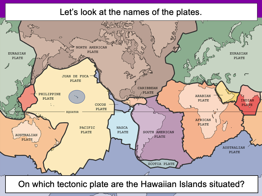
This lesson is designed for KS2 students. It can be taught as a stand alone lesson but is also available as part of three wider units, all of which are available on TES:
-Volcanoes
-Earthquakes
-Volcanoes & Earthquakes
The presentation introduces the idea that the world’s crust is split into tectonic plates and looks at how these are related to volcanoes and earthquakes.
The activity challenges students to identify tectonic plates using a map. It is differentiated two ways:
Easier – Students identify the world’s tectonic plates using a colour-coordinated map.
Harder – Students identify the world’s tectonic plates using a plain map.
Extension – Students use an atlas to find out which tectonic plate countries of the world are located on.
If you like this resource, we would appreciate a review! We will happily send you a free resource in return for a review or useful suggestions/feedback. Contact us at ed@teachitforward.co.uk.
This lesson is designed for KS2 students. It can be taught as a stand alone lesson but is also available as part of two wider units, both of which are available on TES:
-Volcanoes
-Volcanoes & Earthquakes
The presentation investigates the five deadly features of a volcanic eruption including volcanic ash, lava flows, volcanic bombs, pyroclastic flows and mud flows (or ‘lahars’).
The activity challenges students to match pictures of each feature to a description. It is differentiated four ways:
Easier – Students match pictures of the five features of a volcanic eruption to the descriptions.
Medium – Students complete cloze procedure sentences. They then match pictures to each description.
Harder – Students complete cloze procedure sentences. They then match pictures to each description and add a title for each section.
Hardest – Children stick pictures of the five features of a volcanic eruption in their books and write their own description next to each one.
Extension – Which feature of a volcanic eruption do children think is the most deadly? Can they explain their answer?
If you like this resource, we would appreciate a review! We will happily send you a free resource in return for a review or useful suggestions/feedback. Contact us at ed@teachitforward.co.uk.
This lesson is designed for KS2 students and is a great introduction to any volcanoes or earthquakes topic. It can be taught as a stand alone lesson but is also available as part of three wider units, all of which are available on TES:
-Volcanoes
-Earthquakes
-Volcanoes & Earthquakes
The presentation investigates the structure of the Earth and looks into the basic composition of the inner core, outer core, mantle and crust.
Students then complete an activity which is differentiated three ways:
Easier – Students label layers of the Earth and complete cloze procedure paragraph (6 gaps).
Medium – Students label layers of the Earth and complete cloze procedure paragraph (10 gaps).
Harder – Students label layers of the Earth – including drawing arrows – and complete cloze procedure paragraph (10 gaps).
Extension – Students think about what they would like to find out about volcanoes or earthquakes or both, depending on which topic you are doing.
If you like this resource, we would appreciate a review! We will happily send you a free resource in return for a review or useful suggestions/feedback. Contact us at ed@teachitforward.co.uk.
This lesson is designed for KS2 students. It can be taught as a stand alone lesson but is also available as part of two wider units, both of which are available on TES:
-Volcanoes
-Volcanoes & Earthquakes
First the presentation introduces some of the world’s most famous volcanoes and classes them as active, dormant or extinct.
The activity then challenges students to locate volcanoes using an atlas or the internet (e.g. Google maps). Alternatively, a map of famous world volcanoes is also provided.
Easier – Students locate volcanoes using the map of famous volcanoes (writing numbers).
Medium – Students locate volcanoes using the map of famous volcanoes (writing volcano names).
Harder – Students locate volcanoes using an atlas.
(N.B. It is recommended you check the atlas has the relevant maps prior doing the activity.)
If you like this resource, we would appreciate a review! We will happily send you a free resource in return for a review or useful suggestions/feedback. Contact us at ed@teachitforward.co.uk.
This lesson is part of Exploring Spain, a Geography unit designed for upper KS2 students (Y4-6), but can also be taught as a stand alone lesson.
First the presentation covers key vocabulary (e.g. population, currency). It then locates Spain within Europe, asks students what they know about Spain and challenges them to think of ways to find out more.
There are two activities:
Research Activity:
Students research Spain using information sources (e.g. information books or suggested websites).
Easier – Students research famous landmarks, people, wildlife and Spanish food.
Harder – Students choose their own topics to research.
Extension: – Students draw pictures for each topic or find appropriate images online.
Writing Activity:
Students write a fact file using the information they have found.
Easier – Students write about famous landmarks, people, wildlife and Spanish food.
Harder – Students write about their own topics.
Extension – Students draw pictures or stick photos into the boxes for each topic.
If you like this resource, we would appreciate a review! We will happily send you a free resource in return for a review or useful suggestions/feedback. Contact us at ed@teachitforward.co.uk.
This is the free planning overview for London Zoo, a fun introduction to one of the world’s most famous zoos. A topic title page is also included.
This cross-curricula unit is designed for KS1 and lower KS2 students (Y2-4) and includes fully-planned lessons complete with differentiated activities and worksheets.
All the resources described in this unit plan are available on TES, either as individual lessons or as a bundle. Lessons include:
L1 – Writing a fact file about London Zoo
L2 – Taking a tour of London Zoo
L3 – Using compass directions at London Zoo
L4 – Using grid references at London Zoo
L5 – Matching animals to their habitat
L6 – The history of London Zoo
If you like this resource, we would appreciate a review! We will happily send you a free resource in return for a review or useful suggestions/feedback. Contact us at ed@teachitforward.co.uk.
This lesson is part of a wider unit called Exploring St Lucia and is designed to teach KS2 students about a contrasting non-European country.
This lesson looks at similarities and differences between St Lucia and the UK including:
– location in the world
– population
– languages
– currency
– heads of state
– physical geography
– types of employment
In the partner activity students sort statements about the countries into two groups – those describing St Lucia and those describing the UK. It is differentiated two ways:
Easier – Students sort statements about St Lucia and the UK (using stickers and a worksheet).
Harder – Students sort statements about St Lucia and the UK (completed in an exercise book).
Extension – Students think of similarities & differences between St Lucia and the UK.
If you like this resource, we would appreciate a review! We will happily send you a free resource in return for a review or useful suggestions/feedback. Contact us at ed@teachitforward.co.uk.
This is the free planning overview for Exploring St Lucia, a colourful introduction to the geography of St Lucia, a beautiful tropical island in the Caribbean. A topic title page is also included.
The unit is designed for students in KS2 and includes six engaging lessons complete with differentiated activities and worksheets.
All the resources described in this unit plan are available on TES, either as individual lessons or as a bundle. Lessons include:
L1 – Locating St Lucia in the Caribbean
L2 – Identifying the human and physical features of St Lucia
L3 – Investigating satellite photos of St Lucia
L4 – Using compass directions to locate places in St Lucia
L5 – Comparing the weather of St Lucia and the UK
L6 – Comparing St Lucia with the UK
If you like this resource, we would appreciate a review! We will happily send you a free resource in return for a review or useful suggestions/feedback. Contact us at ed@teachitforward.co.uk.
This lesson is part of Mountain Environments, a Geography unit designed for students in upper KS2 (Y4-6).
First the presentation introduces some of the most famous mountain ranges from around the world.
The differentiated activity then challenges students to locate the world’s mountain ranges and encourages them to use and explore atlases. It is recommended that students do the activity in pairs.
Easier – Students identify the world’s famous mountain ranges (less writing).
Medium – Students identify the world’s famous mountain ranges (first letter clues)
Harder – Students identify the world’s famous mountain ranges (no clues)
If you like this resource, we would appreciate a review! We will happily send you a free resource in return for a review or useful suggestions/feedback. Contact us at ed@teachitforward.co.uk.
Understanding Trade is a Geography unit suitable for upper KS2 (Y5-6) and is a great way to teach students about global trade.
The planning overview, topic title page and vocabulary page can be downloaded for free here. Lessons include:
L1 – Investigating where the products we buy come from
L2 – Understanding that all products have a supply chain
L3 – Exploring the chocolate supply chain
L4 – Investigating the UK’s biggest exports
L5 – Investigating the highest value exports of different countries
L6 – Is the banana trade fair? (FREE)
Each lesson includes a presentation and differentiated activities/worksheets.
If you like this resource, we would appreciate a review! We will happily send you a free resource in return for a review or useful suggestions/feedback. Contact us at ed@teachitforward.co.uk.
This is the free planning overview for Understanding Trade, a Geography topic designed to help student understand global trade. A topic title page is also included.
The unit is suitable for KS2 students from Y5 to Y6 and includes six fully-planned lessons complete with differentiated activities and worksheets.
All the resources described in this unit plan are available on TES, either as individual lessons or as a bundle. Lessons include:
L1 – Investigating where the products we buy come from
L2 – Understanding that all products have a supply chain
L3 – Exploring the chocolate supply chain
L4 – Investigating the UK’s biggest exports
L5 – Investigating the highest value exports of different countries
L6 – Is the banana trade fair?
If you like this resource, we would appreciate a review! We will happily send you a free resource in return for a review or useful suggestions/feedback. Contact us at ed@teachitforward.co.uk.
This lesson is part of Understanding Trade, a Geography unit designed for students in upper KS2 (Y5-6).
The presentation first asks students to think about how the products we buy arrive in the shops. It then introduces the concept of supply chains. To explain this concept, students look at the processes involved in the production of milk.
There are two activities:
Group Activity:
Students sort and sequence four mixed up supply chains including those of bananas, T-shirts, bookshelves and coffee.
Individual Activity:
Students sequence the supply chains of bananas, T-shirts, bookshelves and coffee.
Easier – Students sequence supply chains (first and last process given)
Harder – Students sequence supply chains (no clues)
If you like this resource, we would appreciate a review! We will happily send you a free resource in return for a review or useful suggestions/feedback. Contact us at ed@teachitforward.co.uk.
Exploring Spain is a Geography unit suitable for KS2 (Y4-6).
The planning overview, topic title page and vocabulary page can be downloaded for free here. Lessons include:
L1 – Writing a Spain fact file
L2 – Identifying human and physical features of Spain
L3 – Using 8 points of the compass to locate cities in Spain
L4 – Using 4-figure grid references in Spain
L5 – Investigating Spain’s weather and climate
L6 – Taking a tour of Madrid
Optional lesson – Identifying the countries and capital cities of Europe
Each lesson includes a presentation and differentiated activities/worksheets.
If you like this resource, we would appreciate a review! We will happily send you a free resource in return for a review or useful suggestions/feedback. Contact us at ed@teachitforward.co.uk.
This is the free planning overview for Exploring Spain, a great introduction to the geography of Spain. A vocabulary page and topic title page are also included.
This unit is designed for students in KS2 from Y4 to Y6 and includes seven fully-planned lessons complete with differentiated activities and worksheets.
All the resources described in this unit plan are available on TES, either as individual lessons or as a bundle. Lesson include:
L1 – Writing a Spain fact file
L2 – Identifying human and physical features of Spain
L3 – Using 8 points of the compass to locate cities in Spain
L4 – Using 4-figure grid references in Spain
L5 – Investigating Spain’s weather and climate
L6 – Taking a tour of Madrid
Optional lesson – Identifying the countries and capital cities of Europe
If you like this resource, we would appreciate a review! We will happily send you a free resource in return for a review or useful suggestions/feedback. Contact us at ed@teachitforward.co.uk.
This lesson is part of Exploring Spain, a Geography unit designed for upper KS2 students (Y4-6), but can also be taught as a stand alone lesson.
In the presentation students embark on a tour of Madrid, learning interesting facts about Spain’s capital city along the way. They visit sites including the famous Royal Palace, the Sun Gate and the Santiago Bernabeú Stadium, home of Real Madrid.
The lesson has two activities:
Quiz activity:
Students use an online encyclopedia to answer questions about Madrid.
Guided tour writing activity:
Students give their very own guided tour of Madrid.
Easier – Students write a guided tour of Madrid using a writing frame.
Harder – Students write a guided tour of Madrid by sticking images into their exercise books.
If you like this resource, we would appreciate a review! We will happily send you a free resource in return for a review or useful suggestions/feedback. Contact us at ed@teachitforward.co.uk.
This lesson is part of Exploring Spain, a Geography unit designed for upper KS2 students (Y4-6), but can also be taught as a stand alone lesson.
The presentation first recaps the climate zones of the world (i.e. tropical, temperate & polar zones) and locates Spain within these.
It then looks in more detail at Spain’s weather, climate zones and the climate of Madrid. Students are then encouraged to find clues about Madrid’s weather using a climate graph.
This lesson includes two activities:
Comprehension activity:
Students interpret climate graphs for Madrid and London and compare the climates of both cities.
ICT activity:
Students create their own climate graph for Madrid using Microsoft Excel.
If you like this resource, we would appreciate a review! We will happily send you a free resource in return for a review or useful suggestions/feedback. Contact us at ed@teachitforward.co.uk.