I've worked in primary teaching for over 10 years and specialise in creating fun and engaging educational resources, particularly for Geography and History.
I've worked in primary teaching for over 10 years and specialise in creating fun and engaging educational resources, particularly for Geography and History.
This lesson is part of Mountain Environments, a Geography unit designed for students in upper KS2 (Y4-6).
First the presentation looks at features of a mountain climate including lower temperatures and increased rainfall. It then focuses in more detail on the climate of Mount Everest.
There are two activities:
Interpreting climate graphs
In this activity students look at and answer questions about temperature graphs for both the summit and base camp of Mount Everest. It is differentiated two ways:
Easier – Students answer questions about temperature graphs for Mount Everest (suitable for Year 4 and 5).
Harder – Students answer questions about temperature graphs for Mount Everest (suitable for Year 6).
Creating a climate graph in Excel
In this ICT activity, students create their own climate graph, including temperature and rainfall, for the summit of Mount Everest using Microsoft Excel.
If you like this resource, we would appreciate a review! We will happily send you a free resource in return for a review or useful suggestions/feedback. Contact us at ed@teachitforward.co.uk.
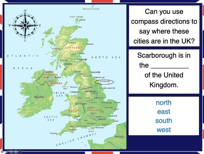
This lesson is part of Exploring the United Kingdom, a Geography unit designed for KS1 and lower KS2 (Y2-4).
N.B. If students are new to compass directions, use Introduction to compass directions to introduce the topic prior to this lesson.
First the presentation reminds students of the four cardinal compass directions. It then encourages them to use compass directions to describe the position of towns and cities around the UK.
In the activity, students have to find UK cities using compass clues. There are two differentiated activity worksheets:
Easier – Students locate cities using compass clues and starting letter clues.
Harder – Students locate cities using compass and harder starting letter clues.
Extension – Students complete cloze procedure sentence about the location of cities in the UK.
If you like this resource, we would appreciate a review! We will happily send you a free resource in return for a review or useful suggestions/feedback. Contact us at ed@teachitforward.co.uk.
This lesson is part of Exploring Spain, a Geography unit designed for upper KS2 students (Y4-6), but can also be taught as a stand alone lesson.
Students first learn about the Iberian peninsula. They then explore some of the main geographical features of Spain itself and categorise these into human (e.g. cities) and physical (e.g. mountains).
The activity challenges students to identify these features on a map of Spain. It is differentiated two ways:
Easier – Students identify human & physical features of Spain using a colour-coded map and word bank
Harder – Students identify human & physical features of Spain using a map & word bank
Extension – Students complete a cloze procedure text about the human and physical geography of Spain.
If you like this resource, we would appreciate a review! We will happily send you a free resource in return for a review or useful suggestions/feedback. Contact us at ed@teachitforward.co.uk.
This lesson is part of Exploring Spain, a Geography unit designed for upper KS2 students (Y4-6), but can also be taught as a stand alone lesson.
The presentation first recaps the climate zones of the world (i.e. tropical, temperate & polar zones) and locates Spain within these.
It then looks in more detail at Spain’s weather, climate zones and the climate of Madrid. Students are then encouraged to find clues about Madrid’s weather using a climate graph.
This lesson includes two activities:
Comprehension activity:
Students interpret climate graphs for Madrid and London and compare the climates of both cities.
ICT activity:
Students create their own climate graph for Madrid using Microsoft Excel.
If you like this resource, we would appreciate a review! We will happily send you a free resource in return for a review or useful suggestions/feedback. Contact us at ed@teachitforward.co.uk.
This resource is designed for teaching the Great Fire of London KS1 History unit. You can download the planning for free here. It is suitable for Year 2 children and more able Year 1 children.
The presentation explores how the Great Fire of London gave birth to the very first fire brigades in the late 17th century. It also looks at how fire safety has improved, including changes in our homes and innovations in fire fighting equipment.
There are two differentiated worksheets which challenge children to sort fire safety related pictures and vocabulary into ‘Now’ and ‘Then (1666)’. They include:
a standard activity sheet with eight words/phrases for children to draw and label
an easier activity sheet (with stickers) with ten words/phrases for children to label
If you like this resource, we would appreciate a review! We will happily send you a free resource in return for a review or useful suggestions/feedback. Contact us at ed@teachitforward.co.uk.
This lesson is part of Exploring Brazil, a Geography unit designed for students in KS2 (Y4-6), but can also be taught as a stand alone lesson.
The presentation introduces students to Brazil’s six main biomes including the tropical rainforest, caatinga (desert), Pantanal wetlands, cerrado (savannah) and Atlantic Forest. Students then read an information text to find out more.
In the activity, students write an information text about Brazil’s ecosystems. This can either be done as a short activity or as an extended write in Literacy. (N.B. The activity sheets need to be enlarged to A3 size to provide adequate space for writing.)
Short Activity:
Easier – Students match statements to each ecosystem and write them in each box.
Medium – Students add titles, then match statements to each ecosystem and write them in each box.
Harder – Students add titles and write their own sentences about each ecosystem in the box.
Extension – Students label the different ecosystems on the map, including drawings of animals found in each one.
Extended Writing Activity:
Easier – Students write an information text about Brazil’s ecosystems, including an introductory paragraph.
Harder – Students write an information text about Brazil’s ecosystems, including sub-headings and an introductory paragraph.
If you like this resource, we would appreciate a review! We will happily send you a free resource in return for a review or useful suggestions/feedback. Contact us at ed@teachitforward.co.uk.
This set of resources is designed for teaching the Great Fire of London KS1 History unit. You can download the planning for free here. It is suitable for Year 2 children and more able Year 1 children.
The presentation introduces Samuel Pepys and extracts of his diary which recorded his eyewitness account of the Great Fire of London . The activity challenges children to investigate this primary source to find out more about the events of September 1666.
There are two differentiated worksheets:
- one has an extract from Pepys’ diary and comprehension questions
- one has an extract from Pepys’ diary and comprehension questions with coloured text to help children find the answers
If you like this resource, we would appreciate a review! We will happily send you a free resource in return for a review or useful suggestions/feedback. Contact us at ed@teachitforward.co.uk.
This lesson is part of Investigating Rivers, a unit designed for upper KS2 (Y4-6).
It introduces many key river concepts and a wide range of related vocabulary. First the presentation recaps the main processes of the water cycle. It then introduces some of the well known features of river systems (e.g. waterfalls and lakes). There are two activities:
Group Activity:
Students are challenged to match eight features of river systems to photos, satellite images and maps. This activity can easily be differentiated by giving groups different numbers of cards.
Individual Activity:
In the worksheet activity students identify the same features on a simplified drawing of a river system. It is differentiated two ways:
Easier – Students identify river features and complete cloze procedure definitions.
Harder – Students identify river features and write their own definitions of four river features.
If you like this resource, we would appreciate a review! We will happily send you a free resource in return for a review or useful suggestions/feedback. Contact us at ed@teachitforward.co.uk.
This lesson is part of Investigating Rivers, a unit designed for upper KS2 (Y4-6).
Students are first introduced to the three stages of a river – the upper course, middle course and lower course – and some of the key features of each. The presentation then challenges students to think about the characteristics of rivers in these different stages (e.g. altitude, channel width, water speed).
In the activity, students match descriptions to each stage of a river. It is differentiated two ways:
Easier – Students match colour-coded descriptions to either the upper, middle or lower course of a river.
Harder – Students match descriptions to either the upper, middle or lower course of a river.
If you like this resource, we would appreciate a review! We will happily send you a free resource in return for a review or useful suggestions/feedback. Contact us at ed@teachitforward.co.uk.
This lesson is part of Exploring Spain, a Geography unit designed for upper KS2 students (Y4-6), but can also be taught as a stand alone lesson.
The presentation first shows students how to work out a 4-figure grid reference.
The activity then challenges students to describe the position of different cities in Spain using 4-figure grid references. It is differentiated two ways:
Easier – Students locate Spanish cities using 4-figure grid references (with clues).
Harder – Students locate Spanish cities using 4-figure grid references.
Extension – Students identify Spanish cities using compass direction and grid reference clues.
If you like this resource, we would appreciate a review! We will happily send you a free resource in return for a review or useful suggestions/feedback. Contact us at ed@teachitforward.co.uk.
This lesson is part of Investigating Rivers, a unit designed for upper KS2 (Y4-6).
It challenges students to think about all the different ways we use water and where we get it from. Are these necessary (needs) or luxury (wants)?
Students then categorise these uses of water as agricultural, recreational, commercial/industrial or community. Lastly, they consider how we can balance human water requirements with those of Earth’s wildlife.
In the activity students sort photos of different water uses into six different categories:
Household
Commercial/industrial
Recreational
Agricultural
Community
Wildlife
In the extension activity, students classify each water use as either necessary or luxury and explain their reasoning.
If you like this resource, we would appreciate a review! We will happily send you a free resource in return for a review or useful suggestions/feedback. Contact us at ed@teachitforward.co.uk.
This lesson is part of Exploring the United Kingdom, a Geography unit designed for KS1 and lower KS2 (Y2-4).
The presentation first introduces students to satellite photos before going on to challenge them to match satellite photos to famous UK landmarks (e.g. Wembley Stadium, Edinburgh Castle).
In the activity, students use their geography detective skills to describe satellite photos and infer which famous UK landmark or feature each one is. It is differentiated two ways:
Easier – Students write description of each satellite photo on a writing template sheet.
Harder – Students stick satellite photos into their exercise book and write descriptions next to them.
If you like this resource, we would appreciate a review! We will happily send you a free resource in return for a review or useful suggestions/feedback. Contact us at ed@teachitforward.co.uk.
This lesson is part of Exploring Brazil, a Geography unit designed for students in KS2 (Y4-6), but can also be taught as a stand alone lesson.
It gives students a chance to find out all about Brazil. The presentation introduces key vocabulary (e.g. population, currency) and then asks students what they know about Brazil and how they could find out more.
There are two activities:
Research Activity:
Students research Brazil using information sources (e.g. information books or suggested websites).
Easier – Students research famous landmarks, people, wildlife and Brazilian food.
Harder – Students choose their own topics to research.
Extension: – Students draw pictures for each topic or find appropriate images online.
Writing Activity:
Students write a fact file using the information they have found.
Easier – Students write about famous landmarks, people, wildlife and Brazilian food.
Harder – Students write about their own topics.
Extension – Students draw pictures or stick photos into the boxes for each topic.
If you like this resource, we would appreciate a review! We will happily send you a free resource in return for a review or useful suggestions/feedback. Contact us at ed@teachitforward.co.uk.
This lesson is part of Understanding Trade, a Geography unit designed for students in upper KS2 (Y5-6).
First the presentation asks students to consider how everyday products arrive in our supermarkets. It then introduces and explains the concept of supply chains, looking specifically at the chocolate supply chain. There are two activities:
Group Activity:
The group activity challenges students to order the chocolate supply chain.
Writing Activity:
An accompanying writing activity is based on ‘The Story of Our Chocolate Journey’ (available on YouTube). It challenges students to sequence and explain the processes involved in the chocolate supply chain. It is differentiated three ways:
Easier – Students use a writing frame.
Harder – Students write in an exercise book using a vocabulary prompt.
If you like this resource, we would appreciate a review! We will happily send you a free resource in return for a review or useful suggestions/feedback. Contact us at ed@teachitforward.co.uk.
This lesson is part of Exploring the United Kingdom, a Geography unit designed for KS1 and lower KS2 (Y2-4).
In the lesson, students learn about the four seasons and characteristics associated with each. First they have to guess each season using different clues. They then find out about the different types of weather associated with each season.
The colourful activity is differentiated three ways:
Easier – Students match 16 pictures (with labels) to the seasons.
Medium – Students match 20 pictures (with labels) to the seasons.
Harder – Students match 20 pictures to the seasons and label them.
If you like this resource, we would appreciate a review! We will happily send you a free resource in return for a review or useful suggestions/feedback. Contact us at ed@teachitforward.co.uk.
This lesson is part of Mountain Environments, a Geography unit designed for students in upper KS2 (Y4-6).
First the presentation recaps the structure of the Earth and how its crust is split into tectonic plates. It then investigates the different ways tectonic plates can move and how two tectonic plates colliding can form fold mountains (e.g. the Himalayas).
The differentiated activity challenges students to work out which tectonic plates formed different fold mountain ranges around the world.
Easier – Students have to find one tectonic plate.
Medium – Students have to find two tectonic plates.
Harder – Students find the name of each mountain range and two tectonic plates.
Extension – Students complete a cloze procedure paragraph about fold mountains.
If you like this resource, we would appreciate a review! We will happily send you a free resource in return for a review or useful suggestions/feedback. Contact us at ed@teachitforward.co.uk.
This lesson is designed for KS2 students. It can be taught as a stand alone lesson but is also available as part of two wider units, both of which are available on TES:
-Volcanoes
-Volcanoes & Earthquakes
The presentation investigates the five deadly features of a volcanic eruption including volcanic ash, lava flows, volcanic bombs, pyroclastic flows and mud flows (or ‘lahars’).
The activity challenges students to match pictures of each feature to a description. It is differentiated four ways:
Easier – Students match pictures of the five features of a volcanic eruption to the descriptions.
Medium – Students complete cloze procedure sentences. They then match pictures to each description.
Harder – Students complete cloze procedure sentences. They then match pictures to each description and add a title for each section.
Hardest – Children stick pictures of the five features of a volcanic eruption in their books and write their own description next to each one.
Extension – Which feature of a volcanic eruption do children think is the most deadly? Can they explain their answer?
If you like this resource, we would appreciate a review! We will happily send you a free resource in return for a review or useful suggestions/feedback. Contact us at ed@teachitforward.co.uk.
This lesson is part of Understanding Trade, a Geography unit designed for students in upper KS2 (Y5-6).
The presentation introduces the concept of highest value exports. It then draws a link between a country’s highest value export and its human and physical resources (e.g. transport links, oil reserves). Four example countries and their highest value export are then looked at in more detail.
In the activity, students are challenged to identify the highest value exports and GDP/capita of countries around the world using Google Maps/atlases and an online map. The activity is differentiated three ways:
Easier – Students identify highest value exports of 25 countries
Medium – Students identify highest value exports and GDP/capita of 25 countries
Harder – Students identify highest value exports and GDP/capita of 30 countries
If you like this resource, we would appreciate a review! We will happily send you a free resource in return for a review or useful suggestions/feedback. Contact us at ed@teachitforward.co.uk.
This lesson is designed for KS2 students. It can be taught as a stand alone lesson but is also available as part of two wider units, both of which are available on TES:
-Volcanoes
-Volcanoes & Earthquakes
First the presentation locates the Caribbean island of Montserrat. It then looks in detail at the eruption of the Soufriere Hills volcano from 1995-99 and the devastating impact on the island.
There are two activities which accompany this lesson, plus extension activities:
Quiz Activity:
Video quiz activity which can be done in pairs/groups.
Writing Activity:
Students write a volcano fact file about the Soufriere Hills volcanic eruptions. This is differentiated three ways:
Easier – Students have statements to stick or copy into their fact file.
Medium – Students have a sequenced vocabulary prompt to scaffold their writing.
Harder – Students have an unsequenced vocabulary prompt to support their writing.
Extension – Students complete a cloze procedure text about the eruptions of Soufriere Hills.
If you like this resource, we would appreciate a review! We will happily send you a free resource in return for a review or useful suggestions/feedback. Contact us at ed@teachitforward.co.uk.
This lesson is part of Mountain Environments, a Geography unit designed for students in upper KS2 (Y4-6).
N.B. Ideally students have a grounding in latitude and longitude prior to this lesson. The unit Understanding Latitude & Longitude is an ideal introduction to the topic.
First the presentation introduces students to latitude and longitude and goes through how to find the coordinates of a point step-by-step. It then asks students to find the latitude and longitude of several world capital cities.
The activity and extension then challenge children to locate famous world mountains using their latitude and longitude:
Easier - Students locate 12 famous world mountains using latitude and longitude.
Harder - Students locate 16 famous world mountains using latitude and longitude.
Extension - Students add more famous mountains to their world map using latitude and longitude clues.
If you like this resource, we would appreciate a review! We will happily send you a free resource in return for a review or useful suggestions/feedback. Contact us at ed@teachitforward.co.uk.