I'm a Geography teacher with experience educating at various levels, ranging from mainstream schools, SEN and extra-curricular tuition. I also have experience in teaching humanities, English and PSHE topics. My resources are designed primarily as schemes of works for mainly Geographical topics with all levels considered
I'm a Geography teacher with experience educating at various levels, ranging from mainstream schools, SEN and extra-curricular tuition. I also have experience in teaching humanities, English and PSHE topics. My resources are designed primarily as schemes of works for mainly Geographical topics with all levels considered
This booklet introduces the students to why we carry out fieldwork within Geography for coursework or class investigations, and the types and uses of data sources. Four and six figure grid references are explained and practised alongside learning OS map symbols. Environmental surveys are carried out within their learning surroundings, with their positive and negative aspects being discussed.
The students practice drawing their own field sketches having discussed the “Do’s” and “Don’ts” of these and carry out a practical using quadrats in which they build their bar graph skills by presenting their results. Measuring litter gives the students the opportunity to survey their school grounds and progress their pie graph skills and draw conclusions from their results. The booklet concludes with a discussion of appropriate and suitable questions for questionnaires.
A range of individual and group activities are incorporated within this booklet, including, gathering research from print and in person, drawing graphs and annotating the data, as well as discussing the pros and cons of each technique and how some of these can be overcome or restricted.
Please like and follow us on Facebook @WillsonEducation or Pinterest @willsoned for more exciting resources, activities, and upcoming events to incorporate into your lessons.
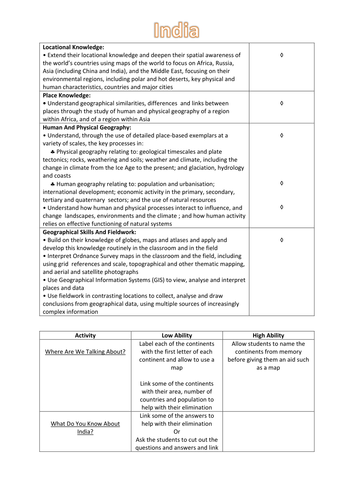
This 62 page booklet allows students to explore India through a variety of activities both students and teacher lead. Chapters include, amongst others,:
Why Travel To India?
What Is India’s Climate Like?
What Makes Up India’s Culture?
A Taste Of India?
Taj Mahal
Ganges River
Himalayas
Thar Desert
India’s Wealth
Cycle Of Poverty
What’s In India’s Future?
For further resources on Hinduism and Diwali please visit:
https://www.tes.com/teaching-resource/hinduism-ks-3-and-4-10000468
https://www.tes.com/teaching-resource/diwali-ks-3-and-4-11147240
This 60 page booklet allows students to explore Brazil through a variety of activities both students and teacher lead. Chapters include, amongst others:
What Do You Know About Brazil?
Why Travel To Brazil?
What’s The Landscape Like In Brazil?
What Is Brazil’s Climate like?
What Is Brazil’s Vegetation Like?
What Is Brazil’s Culture Like?
A Taste Of Brazil
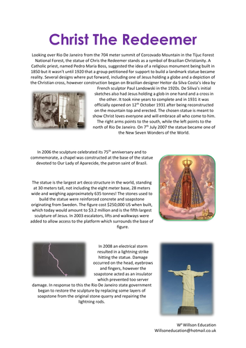
Christ The Redeemer
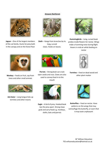
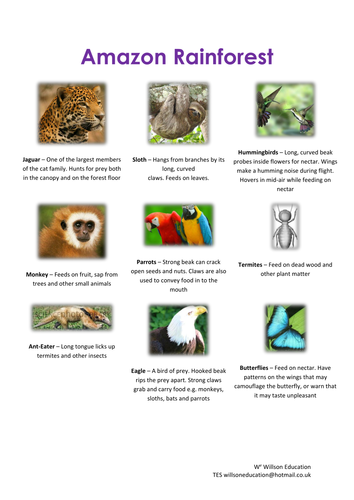
Amazon Rainforest
Sugarloaf Mountain
Iguazu Falls
Rio Carnival
How Does The South Of Brazil Compare To The Rest Of The Country?
How Is Brazil’s Population Distributed?
Who Lives In The City?
Who Lives In The Rainforest?
Brazil’s Threatened Wildlife
Can The Urucu Gas Project Provide Energy For Manaus Without Harming The Environment?
For resource about the Rio 2016 Olympics please refer to:
www.tes.co.uk/teaching-resource/olympic-booklet--rio-2016-ks-3-and-4-11060224
This 29 page booklet gives students the opportunity to explore the Olympics and Brazil using different Geographical themes and skills. Chapters include:
History Of The Olympics
The Rings
Rio De Janeiro – Host City 2016
London’s Olympic Legacy
City Climate
Seeing The Sites
Population And Nationality
General Geography Of Olympic Countries
Build A Brand
For an additional booklet about Brazil please visit:
https://www.tes.co.uk/teaching-resource/brazil-ks3-and-4-11073383
This 60 page booklet allows students to explore Brazil through a variety of activities both students and teacher lead. Chapters include, amongst others:
What Do You Know About Brazil?
Why Travel To Brazil?
What’s The Landscape Like In Brazil?
What Is Brazil’s Climate like?
What Is Brazil’s Vegetation Like?
What Is Brazil’s Culture Like?
A Taste Of Brazil
Christ The Redeemer
Amazon Rainforest
Sugarloaf Mountain
Iguazu Falls
Rio Carnival
How Does The South Of Brazil Compare To The Rest Of The Country?
How Is Brazil’s Population Distributed?
Who Lives In The City?
Who Lives In The Rainforest?
Brazil’s Threatened Wildlife
Can The Urucu Gas Project Provide Energy For Manaus Without Harming The Environment?
For resource about the Rio 2016 Olympics please refer to:
www.tes.co.uk/teaching-resource/olympic-booklet--rio-2016-ks-3-and-4-11060224
Seven fun brainteasers and images which could be used as lesson starters or displayed in the classroom and corridor in a Geography department.
Please like and follow us on Facebook @WillsonEducation or Pinterest @willsoned for more exciting resources, activities, and upcoming events to incorporate into your lessons.
This five page activity allows students to explore where Las Vegas is, whether it is sustainable, why it is so dry and how they are trying to over come this by using Xeriscaping
This Unit Of Work helps students to define ‘food deserts’ and outline research which has attempted to identify these within the United Kingdom. They will be able to explain how the location of food outlets within the United Kingdom and America influence the geography of affordable health food baskets and identify what is meant by ‘obesogenic environments.’ In addition, they will be able to establish whether the physical environment has an impact to exercise and whether there is a link between social deprivation and fast-food availability.
A range of individual and group activities are incorporated within this booklet for students including; drawing and explaining their thoughts and ideas, drawing maps and graphs and interpreting all of these.
Please like and follow us on Facebook @WillsonEducation or Pinterest @willsoned for more exciting resources, activities, and upcoming events to incorporate into your lessons.
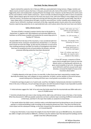
This unit of work begins with how mountains are defined, where they are located and how they are formed. We look at the weather in mountainous areas and its effects on shaping mountains. We explore the human and physical influences on landslides, avalanches, and glaciers. An investigation delves into how we use mountainous areas, specifically The Alps and Atlas Mountains. This leads to exploring Everest Base Camp and the Chagga people who live on Mount Kilimanjaro.
The social, economic, and environmental impacts of visitors is discussed with a look at how negative impacts could be diminished within the Lake District. The foreign influence on the Sherpas way of life is studied. We see how plants and animals’ can adapt to life in the Andes which leads to the future of our mountains in terms of climate change and global warming.
The students build on the fieldwork techniques of interpretating photographs and field sketches with Sugarloaf Mountain and Table Mountain. This concludes with asking: “are there monsters in our mountains?” looking at evidence for and against the existence of The Yeti…
A range of individual and group activities are incorporated within this booklet including annotating maps, completing flow diagrams, gathering research independently and from provided print, hands on experiments, case studies, and a peer assessment task.
Please like and follow us on Facebook @WillsonEducation or Pinterest @willsoned for more exciting resources, activities, and upcoming events to incorporate into your lessons.
This booklet introduces the students to some of the many tribes still found around the world, it helps them to understand their individualities, as well as their struggles and accomplishes over their harsh environment, be it the rainforest, mountains, deserts, or an island, and the ever changing modern and outside world. Tribe’s studies are:
The Kayapo Tribe
The Yanomami Tribe
The Matsés Tribe
The Awá
The Chagga People
The Sherpa People
The Quechua Tribe
The San People
The Matmata People
The Pitcairn People
The Inuit People
The Maasai Tribe
A suitable settlement site is investigated before discussing what is meant by an indigenous tribe and their locations around the world. The booklet concludes with the students creating their own tribe and explaining their various characteristics.
A range of individual and group activities are incorporated within this booklet, including, gathering research from print and video, annotating maps, their thoughts, and ideas, drawing graphs and story boards, face painting and peer assessing.
Please like and follow us on Facebook @WillsonEducation or Pinterest @willsoned for more exciting resources, activities, and upcoming events to incorporate into your lessons.
This 5 page worksheet introduced students to what we mean by endangered wildlife and the different grades this can include. It also allows them to look at the human and physical aspects which are threatening our wildlife and what is being tried to overcome this
This unit of work explores England beginning with the country’s location, make up and statistics. England’s landscape is explored using the lyrics from ‘Jerusalem’ and what the students consider the be English are discussed.
England’s population is studied in terms of minorities and majorities, census information and its history to help explain this. Why people would want to move to England is explored with the benefits and problems which may arise from this. The country’s roll within the EU (European Union) and United Nations is explored.
The weather in England is looked at through the physical factors which effect it across four distinct regions, these features are also studied in relation to where people live and human features.
The makeup of the Union Jack is touched upon as well as some of the quirkier sayings from the language. England’s culture is investigated through traditional dress, dance and music, religion, sport, language, royal family, national emblems, and Saint George. The students have the opportunity to discuss and try some products produced within England.
Some of England’s more unusual famous landmarks are explored including the Angel of the North, Cheddar Gorge, Sherwood Forest, Stonehenge, Hadrian’s Wall, and Chalk Figures. In addition, how England’s landscape is used in many blockbuster films is investigated with the positive and negative aspects being considered. The beauty of England’s National Parks is appreciated with a discussion as to whether the South Down should have become one and the resulting fallout from various groups.
The booklet concludes with the students creating a touring holiday for a visiting family to specific location types. This can be differentiated by including accommodation and a travel log.
A range of individual and group activities are incorporated within this booklet, including, annotating maps, their thoughts and ideas, word fills, gathering research from print, drawing, and reading graphs, recording weather, field sketch skills and decision-making exercises.
Please like and follow us on Facebook @WillsonEducation or Pinterest @willsoned for more exciting resources, activities, and upcoming events to incorporate into your lessons.
This 20 page booklet allows students to discover and explore the original seven wonders of the world though individual and group activities. Chapters include:
The Colossus Of Rhodes
The Great Pyramid Of Giza
The Hanging Baskets Of Babylon
The Lighthouse Of Alexandria
The Mausoleum At Halicarnassus
The Statue Of Zeus At Olympia
The Temple Of Artemis At Ephesus
This 69 page booklets allows the students to explore and discover the Seven Original and New Wonders of the World and Natural World through a range of different activities including individual and group tasks. Wonders include:
The Original Seven Wonders Of The World
The Colossus Of Rhodes
The Great Pyramid Of Giza
The Hanging Baskets Of Babylon
The Lighthouse Of Alexandria
The Mausoleum At Halicarnassus
The Statue Of Zeus At Olympia
The Temple Of Artemis At Ephesus
The New Seven Wonders Of The World
Chichen Itza
Christ The Redeemer
The Great Wall Of China
The Taj Mahal
Machu Picchu
Petra
The Roman Colosseum
The Seven Natural Wonders Of The World
Grand Canyon
The Great Barrier Reef
The Harbour At Rio De Janeiro
Mount Everest
Aurora Borealis
Paricutin Volcano
Victoria Falls
The New Seven Natural Wonders Of The World
Iguazu Falls
Halong Bay
Jeju Island
Puerto Pricesa Underground River
Table Mountain
Komodo Island
Amazon Rainforest
This 15 page booklets allows the students to explore and discover the Seven Original and New Wonders of the World and Natural World through a range of different activities including individual and group tasks. Wonders include:
The New Seven Wonders Of The World
Chichen Itza
Christ The Redeemer
The Great Wall Of China
The Taj Mahal
Machu Picchu
Petra
The Roman Colosseum
This 31 page booklets allows the students to explore and discover the Seven Original and New Wonders of the World and Natural World through a range of different activities including individual and group tasks. Wonders include:
The New Seven Wonders Of The World
Chichen Itza
Christ The Redeemer
The Great Wall Of China
The Taj Mahal
Machu Picchu
Petra
The Roman Colosseum
The New Seven Natural Wonders Of The World
Iguazu Falls
Halong Bay
Jeju Island
Puerto Pricesa Underground River
Table Mountain
Komodo Island
Amazon Rainforest
This 32 page booklets allows the students to explore and discover the Seven Original and New Wonders of the World and Natural World through a range of different activities including individual and group tasks. Wonders include:
The Original Seven Wonders Of The World
The Colossus Of Rhodes
The Great Pyramid Of Giza
The Hanging Baskets Of Babylon
The Lighthouse Of Alexandria
The Mausoleum At Halicarnassus
The Statue Of Zeus At Olympia
The Temple Of Artemis At Ephesus
The New Seven Wonders Of The World
Chichen Itza
Christ The Redeemer
The Great Wall Of China
The Taj Mahal
Machu Picchu
Petra
The Roman Colosseum
This 39 page booklets allows the students to explore and discover the Seven Original and New Wonders of the World and Natural World through a range of different activities including individual and group tasks. Wonders include:
The Seven Natural Wonders Of The World
Grand Canyon
The Great Barrier Reef
The Harbour At Rio De Janeiro
Mount Everest
Aurora Borealis
Paricutin Volcano
Victoria Falls
The New Seven Natural Wonders Of The World
Iguazu Falls
Halong Bay
Jeju Island
Puerto Pricesa Underground River
Table Mountain
Komodo Island
Amazon Rainforest
This booklet introduces students to the global links within sports, specifically the Six Nations Rugby tournament. They explore the six countries who play in the competition, England, Scotland, Ireland, Wales, Italy, and France through topics of weather, population, cuisine, coastal landforms, tourism, and multinational companies.
Rugby as an economic activity is explored. We also look at the various aspects of our cultures we have ‘borrowed’ and adapted from our neighbours including language, traditions food, fashion, music, and sports.
The unit concludes with the students designing a brand and logo for a sustainable rugby competition at their school. The final designs are then peer assessed.
A range of individual and group activities are incorporated within this booklet including map reading and annotating, gathering research from print and video, with students drawing their own conclusions from materials gathered.
Please like and follow us on Facebook @WillsonEducation or Pinterest @willsoned for more exciting resources, activities, and upcoming events to incorporate into your lessons.