11Uploads
3k+Views
82Downloads
Geography

GPS Coordinates (Geogebra)
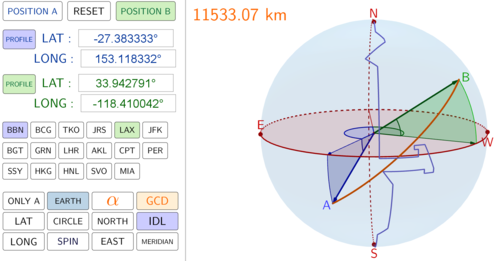
This is a Geogebra program for use as a visual aid in the teaching of coodinates for the Global Positioning System (GPS). This program has been designed for use with Geogebra 5.0 (download version). This resource assists the teacher in clearly showing students how latitude and longitude angles are able to define any position on a 3D simulation of the Earth’s surface. Simply enter a specific GPS position (in degrees, minutes, seconds) and the program will show this location on the Earth. The program also shows a 2D represention of the position in vertical and horizontal planes, which can also be dynamically adjusted. The Earth will also spin so students can clearly identify the position from different perspectives or you can manually rotate the Earth to any perspective.
This is a resource that will visually engage your students, improve their comprehension and save you significant effort from trying to represent three dimensions on a two dimensional surface.

The Great Circle Distance (Geogebra)
This program will show the Great Circle line between any two GPS coordinates over the surface of the Earth. It has been designed for use in Geogebra v5.0 (install version). Simply enter two GPS coordinates and the program will calculate the great circle distance and sweep angle between your two locations. You can also display a 2D circle in a 3D plane to show students how the Great Circle line wraps around the circumference of the circle.
You can highlight the latitude and longitude components of your GPS locations so that students can easily visualise how this navigation system works. Simply click on the “SPIN” button and your students will get a 360 degree view of the situation. I have also pre-programmed some GPS locations for quick access.
This is an excellent tool to help your students visualise a 3D enivronment on a 2D surface.


