My shop is a non profit making concern & it supports homeless charities (Crisis, The Salvation Army & The Berwick Youth Project). Teaching has been my life & I continue to support learning around the World. My subjects were: History, Geography and Physical Education. I have competed in a wide variety of sports inc.: Gymnastics, Badminton, Rugby, Football, Athletics & many others. Check out my recent bundle with 11 of my best publications. A vast amount of support material on offer.
My shop is a non profit making concern & it supports homeless charities (Crisis, The Salvation Army & The Berwick Youth Project). Teaching has been my life & I continue to support learning around the World. My subjects were: History, Geography and Physical Education. I have competed in a wide variety of sports inc.: Gymnastics, Badminton, Rugby, Football, Athletics & many others. Check out my recent bundle with 11 of my best publications. A vast amount of support material on offer.
This is a Power Point Presentation about Poole, Dorset and the Jurrasic Coast. Within the commentary boxes each slide offers fairly simple writing or sketching challenges for students from Year 6 through to GCSE level. The study is presented in such a way that individual students can work through each challenge from home on a PC or lap top. The geographical skills involve drawing of maps, field sketches and analytical writing that will give each student familiarity with common geographical terminology. Working for between 1 and 2 hours per day, this project should last for about 7 session but may last up to 10 one hour sessions in total. There is potential for extension work using the many images that lend themselves to field sketch drawings. This resource is offered at a minimum price of £3 and all income will be forwarded to homeless charities in 2021. It is also offered at this time especially for parents and teachers who are providing children at home with appropriate educational challenges during the Covid crisis.
Orienteering - PPP9
Navigation, Gathering Points and Handrails.
This Power Point Presentation aims to help competitors in the art of navigation. Two ways of making the navigation challenge easier, involves making the most of gathering points and Handrails. The use of these navigation skills can help the novice to progress into an experienced, confident and successful competitor. The presentation offers the following: 1. Map examples of linear map symbols that help the runner to maintain a parallel track to the intended control point. Examples of linear features might be a) a fence, b) a wall, c) the edge of woodland. These are a few of many possibles. 2. In contrast gathering points are a number of isolated map symbols that can also help the runner to progress accurately between two control points. This is particularly useful when following a compass bearing. Isolated map features might include a) a large rock, b) a small thicket, c) an isolated tree d) a ditch running across the direction of travel, etc. There are many more examples. Long navigational legs may have as many as 5 or more gathering points. Gathering points also helps to sub-divide the leg into specific distances.
This presentation also includes a section on how to set a compass bearing using the Silva (plate) compass. As long as you have the map and compass in your hand you will not be lost! However, you may be unsure of your exact location - In these circumstances - check the orientation of the map and look for prominent physical or man made objects nearby to relocate.
Handrails and gathering points help to create bite size challenges. Learning these advanced skills help to establish stress free progress in an Orienteering event. Enjoy the challenges.
Orienteering - PPP10
The Shape of the Land & Understanding the Contours.
The aim of this presentation is to help the beginner and intermediate orienteer to get a mental image of the rise and fall of the landscape. In order to achieve success in this challenge, we need to understand the concept of contour lines. These brown lines on an orienteering map represents the differing levels in the landscape. In terms of altitude each line, (level on the land) could be between 2.5 and 5.0 metres apart. Contour lines close together reflect very steep slopes whereas lines wider apart would describe flat or gradually sloping land. This presentation aims to describe how the landscape can be pictured in one’s own mind thanks to the specific contour patterns shown on the maps. Some of the landscape features have specific names and shapes so they are easier to recognise and identify. Reading the contours and knowing the shapes takes the orienteer to a different level of success.
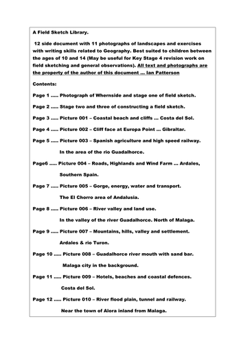
Field sketch drawing. How to draw a field sketch + 10 extra practice photographs for students to develop their drawing and geographical knowledge.
Topics include: Coastlines, beaches, cliffs, tourism, agriculture, road, rail, highlands and river valleys.
This resource is a Tudor timeline covering the main people and events that took place between 1485 and 1603. It is ideal for teachers delivering information about the reign of the Tudors. The resource covers a little more than 118 years of History and would be an ideal support for teachers of History in both the Primary and Secondary sectors. Included are 90 images of people, documents, castles, maps, battles and many other connected visual aids that can support the delivery of History lessons. Throughout this year (2020 - 2021) all of my resources support homeless charities and I hope that with your help we can give a few people on the streets much needed support in getting their lives back on track. Good luck in your Schools and Colleges this coming year 2020 - 2021.
Ian Patterson (IanPCostaDelSol).
Advice and a Warning … Please note that this play makes use of sound effects like irate animals, a rather mad parrot and a deaf old lady who breaks wind!! If you use this resource, I recommend using it in the final lesson of the day. It is not for use by teachers who are faint hearted or do not have a good rapport with their students. Read on if you are interested.
This is both a short story and a short play about Diego the Parrot. The title of the play is “My Neighbour Has A Parrot”. I used to enjoy interactive lessons with my students and in partnership with my classes we used to produce plays, drama sketches and pantomimes. These were the most memorable experiences in my career as a teacher. This resource targets English and Drama or it can be used as a platform for a short stage production. Acting out plays has always been a winner for me. There are lots of sound effects included in this production and it affords the opportunity to have lots of fun with your students. As a play it would last between 10 and 15 minutes. The main characters in this production could include a narrator, old man, old lady, parrot and possibly a sound effects expert! I would target this resource at Key Stage 2 and 3 (Ages 8 to 14 year old). Initially I would read the story to the class (with the sound effects) and then develop the production as a whole class exercise and then, perhaps, in groups of between 4 and 5 children. The main aim of this classroom activity is 1) Building inner confidence and 2) Having fun in the classroom. Further developments can involve creative writing about Diego the parrot. One in particular that I have used in the past would be “Diego and the Ventriloquist”. Each child can have a go at performing and writing a small individual sketch for fun. A toy parrot strapped to the shoulder would be a useful extra. I hope you have fun with this resource.
My shop supports the Berwick Youth Project. This charity helps to keep young people safe and tries to prevent them from ending up on the streets or homeless.
All 2021 income on this resource will go to Homeless Charities. Learn at school or at home about USA Cities.
This presentation can be used for children between the ages of 9 and sixteen. There are fifty five slides and thirty nine pages of additional resource materials. I have selected the following cities because of their contrasting site, situation and geographical locations. They are: Boston, New York, Washington DC, Chicago, Detroit, Las Vegas, Los Angeles, San Francisco and New Orleans. This selection of cities offers extended studies in both Physical and Human Geography. Included in the slide notes and the resource file are suggested work challenges involving on line work, historical links, geographical writing skills, discussions and other map drawing exercises. The presentation can be targeted at nine and ten year old students but it will be necessary to use the shortened version of the script. Children between the age of eleven and fourteen should be able to cope well with most of the challenges. Key Stage 4 (fourteen to sixteen years) students involved in examinations will be able to link this resource with a large range of the exam topics. Some examples include: Boston and New York - Settlements, site, situation and geographical location. New Orleans - Flooding, Mississippi Drainage Basin, River features including deltas. Detroit - Industrial and population change. Chicago and Detroit - Location, Waterways and Trade, Glaciation and the Great Lakes. Los Angeles and San Francisco - Environmental Hazards and Tourism. Las Vegas - Desert environment, Water resources and the Entertainment Industry. Washington DC - Capital City, history, location, population, government and tourism. There are several IT challenges on offer that involve constructing a quiz word grid, following the course of the River Colorado by using on line maps, developing knowledge of site, situation and geographical location with a starting point in Downtown Chicago. The whole project is aimed at developing a wide range of geographical knowledge along with IT skills and the opportunity to improve writing techniques in preparation for higher level studies. I personally would use this resource for Year 9 groups in preparation for Key Stage 4 Geography. The History content makes it just that little bit more interesting.
This chapter highlights the structure and content of an Orienteering Event and it is presented as a Power Point Presentation. The key elements include: The map and planning, Orienteering controls and the officials (the people behind the scenes), Preparing the maps and checking out the lay of the land, Advertising the event and taking in the entries, Setting up a suitable start and finish zone. Other interesting features include aspects of coaching, working with young competitors and also the benefits of family participation.All in all a sport with a healthy outlook and well worth trying.
This resource is part of a larger coaching document and all presentations will serve to support three homeless charities.
Any income from this resource will go to Homeless Charities in the UK
A selection of basic skills for learning about maps. Topics covered include: Use of symbols, Directions and Bearings, Grid References, Contours, Scales and Distances on maps.
This resource offers introduction to map skills and gives the opportunity for students to complete work challenges. This resource unit is best suited to students from 10 years through to 16 years of age.*
A 268 page document with over 50 outline maps from around the World. This resource book is to be used in conjunction with a school atlas. There are a multitude of exercises and challenges for students to use as homework or in the classroom with or without guidance from the teacher. Also included, there are over 180 photographs from the UK and around the World that can be used individually for lesson starters or as topic slide shows.This resource work book can be used with a wide range of age groups. The outline maps and questions are suitable for children between the age of 9 to 16 years. The content has a wide degree of differentiation for more and less able children. The many pictures included in this document are ideal as introductions to new topics. Although the main focus of this resource is on Geography, much of the content can be linked to, Travel and Tourism, History, English and Social Studies. Special featured sections: China, London, Spain, Bristol and WW1 Flanders. All income from this resource will be donated to 3 Homeless Charities in 2021 . The Salvation Army, Crisis and The Berwick Project.
Adolf Hitler 1889 to 1918 – His Early Years and WW1 - This resource comes in the form of a fact file and a selection of classroom exercises that are aimed at 13 to 16 year old students of 20th Century History. In addition to this there is a small section (images) that would be suitable for the PSHE programme especially in the month of November. The material in this 21 page resource documents the birth of Adolf Hitler through to the conclusion of WW1. It contains written information, pictures, maps, quiz questions and research challenges. The research challenges are ideal for perhaps two internet sessions where students need to search for extra information. The contents are best suited for Key Stage 3 and students in Key Stage 4 preparing for History examinations, particularly the topics “The Rise of Adolf Hitler”, “Development of a Dictatorship” and “The Events of WW1”. The resource materials offered should satisfy between 4 and 8 hours of work in the classroom. As an alternative it may also be offered as a home research project in preparation for GCSE examinations.
This resource can be linked and used alongside - Adolf Hitler - Early Years (Powerpoint Presentation created by this same author).
This Powerpoint Presentation is specifically targeting 13 to 16 year old students of History. There are 22 slides with a selection of appropriate pictures, fact files and maps included. It is an introductory part of a wider document about “The Development of a Dictatorship – Adolf Hitler”. The resource documents the early years of Hitler up to the end of World War One and it looks more closely at the experiences that shaped his life. Who and what influenced him as he was growing up in Austria and how did being part of an Infantry Regiment in WW1 mould his character. The critical question is asked, how and why did Hitler take his chosen path to infamy?
In terms of historical understanding, many National Curriculum prerequisites have been covered and include evidence, continuity, change, cause and effect, perspectives, empathy, significance and contestability. However in short, the most important content is evidence of how and why Adolf Hitler turned into a cruel demagogue. A key element in the presentation is the chronological nature of the study. The World War 1 years also offer an ideal opportunity to learn more about the advances in technology.
There are 22 slides with images that are followed by suggested challenges for students to complete. The slides containing maps are available for printing and use in lessons.
Slide 25 offers suggested ways in which the presentation can be managed in the classroom.
Slide 26 to 38 contains sets of quiz questions that are differentiated for a wide range of abilities.
Slide 39 offers writing challenges that are aimed at helping 13 year old students to extend their writing skills from a basic level to advanced levels in preparation for higher examination targets in the future.
Slides 40 to 45 are script notes for use by students who can take part in the presentation if directed by the teacher. This unit of work is ideal for between 3 and 6 hours of commitment in the classroom and possibly for use as a homework challenge.
Income for this resource will go to homeless charities. The work serves to satisfy the type of work associated with field studies and research. The content targets Geography, Travel and Tourism and Business Studies students from 14 to 16 years of age. They will gain experience in handling data related to service industries. The work serves to satisfy the type of work associated with field studies and research. The data is presented on a spreadsheet that highlights the Service Industry of Poole in Dorset. Using the information, students will be able to propose a hypothesis and then attempt to prove or refute the chosen statement.
Within the folder there is a power point presentation that can be used independently as a collection of Geography topics about the English County of Dorset. Specifically it addresses the concepts of Site, Situation and Function of a settlement. The power point presentation alone can be used to support up to 10 contrasting lessons. The photographs can be used for introductions to a number of Human and Physical Geography topics including the following specifics and links:
Poole Port, Service Industry, Tourism, Shopping Streets, Spreadsheet statistics, Bays and Headlands, Lulworth Cove, Lulworth Village, Swanage Bay, Groynes, Stair Hole, Durdle Door, Corfe Castle, Dorset Geology, Settlements, Site, Situation, Function and finally a number of excellent photographs that can be converted to field sketch diagrams.
This resource is a two lesson powerpoint presentation that tracks the developments of the Weimar Republic from its conception (1918) to its final demise (1933). In particular it features the political rise of Adolf Hitler from Lance Corporal to Fuhrer. It takes the form of a timeline of events and the frames can be reduced to create a pack of 48 revision cards. This presentation is ideal for students of History between the ages of 14 and 16. Frames 52 and 53 can be printed for students to compile brief notes on the two presentations. This is a quick fix exercise to help students to put the key events of the Weimar Republic into chronological order. All abilities can learn from the images and discussions inspired by this resource.
Geography Bundle - Price Reduction - Amazing value for money!
All income in 2021 will go to Homeless Charities.
This Geography resource is ideal for home learning.
It is everything I needed when I first started teaching Geography. It targets children from the age of 8 through to 16 and it includes: 1) World Mapwork Skills & literacy. Every possible outline map for Britain, Europe and the rest of the World is included. 2) Basic Skills for teaching OS - mapwork.
3) How to interpret pictures and then convert them into field sketch images.
There are also many challenges offered for writing sentences and passages using geographical terminology and vocabulary. This bundle is a special offer to young teachers of Geography in the Secondary sector. It also targets (KS3 and KS4) . Junior School Teachers responsible for delivering Humanities at Key Stage 2 Level will also find this resource invaluable. The whole package makes up 100’s of lessons.
This resource is aimed at giving Geography, Travel and Tourism and Business Studies students from Years 9 through to 11 the experience of handling data related to service industries. The work serves to satisfy the type of work associated with field studies and research. The data is presented on a spreadsheet that highlights the Service Industry of Poole in Dorset. Using the information, students will be able to propose a hypothesis and then attempt to prove or refute the chosen statement.
Within the folder there is a powerpoint presentation that can be used independently as a collection of Geography topics about the English County of Dorset. Specifically it addresses the concepts of Site, Situation and Function of a settlement. The powerpoint presentation alone can be used to support up to 10 contrasting lessons. The photographs can be used for introductions to a number of Human and Physical Geography topics including the following specifics and links:
Poole Port, Service Industry, Tourism, Shopping Streets, Spreadsheet statistics, Bays and Headlands, Lulworth Cove, Lulworth Village, Swanage Bay, Groynes, Stair Hole, Durdle Door, Corfe Castle, Dorset Geology, Settlements, Site, Situation, Function and finally a number of excellent photographs that can be converted to field sketch diagrams.
The Tudors - From Start to Finish. This resource has been compiled as a time line of events and can be used as an independent home study or Zoom project. This Story about the Tudors is a comprehensive document in the form of a Power Point Presentation. There are over 100 images that give a taste of all that happened during this period of History. The study looks at the highs and lows of the main characters that lived and died during the reign of the Tudors. The whole package takes the form of 15 power point lessons that covers almost every possible topic that can be included within the Tudor Period. Topic examples include: Religion, Rebellion, War, Family, Execution, Affairs at home, Affairs abroad and Slavery to name but a few. Each lesson is concluded with a revision quiz that gives the children the opportunity to develop their writing skills. As all teachers know, History and use of the English language go hand in hand. This resource offers children from the age of 9 through to 16, a colourful opportunity to fully understand what happened during the reign of the Tudors as well as offering an extended project that develops individual literacy skills. The study can be delivered on three levels giving teachers the opportunity to use this resource with different age groups and ability levels.
KS2 topics covered: Teaching Chronology, Black People / Slavery, Spanish Empire, Literacy and History.
KS3 topics covered: Early Modern (16th & 17th Century), The Reformation, Henry VIII + Elizabeth I.
All commission income will go to three different homeless charities. They are: Crisis, Salvation Army and The Berwick Project (Keeping young people off the streets).
This resource targets students studying the Weimar Republic during the period 1918 to 1933. They are most likely to be involved in learning about History in Germany for GCSE examinations in the time period between the two World Wars. Specifically it is aimed at learning time order in this complicated and rapidly changing period of History. There are two main elements to this resource. It starts with a timeline presentation that can be taught as two introductory lessons. After this initial introduction the 48 revision cards can be used to create a wall display and then followed up with a series of revision games that help students to learn the correct order of events during the Weimar years in Germany. As the end of Key Stage 4 examinations get closer the revision cards will be very useful for individual, partner and group revision sessions.
This Project offers an insight into the characteristics of the Yorkshire Dales National Park and it encompasses a taste of the History and the Geography of this diverse area of Northern England. Throughout this resource there is an offering of challenges and tasks for students to attempt. Sub topics include: Glaciation, Geology, Industrial Roots, Roads and Railways, Town and Countryside, Limestone Scenery, Farming, Mapwork Skills and a few others. In total there is enough work for at least 10 lessons that will encompass a wide range of geographical skills within the one project. It is suitable for students with a wide range of abilities from the age of 10 to 16 years. I would introduce this project by looking back at the history of the National Parks. My second focus would be the wider pattern of parks within the USA and then lead into the project which is based specifically on The North Yorkshire National Park in the United Kingdom.
A vast collection of teaching materials from a lifetime of experience. 60% saving. This large bundle will serve a large number of young and experienced teachers alike. In as few words as possible I will explain the potential gains to be had from this vast collection of History, Geography and General Knowledge.
A World and UK collection of outline maps that can be used alongside an Atlas or independently. Hundreds of images & exercises on World Geography. They serve to assist in a huge variety of Humanities lessons.
Check out this map-work resource that covers all of the skills required to read maps and fully understand the use of maps.
This resource gives us a taste of ten cities in the UK. It offers fact file projects and worksheets.
Similar to that listed above. This Power Point Presentation presents 9 contrasting cities in the USA. It gives a taste of both History and Geography.
The Africa Project. This presentation offers up a huge contrast between the physical and human geography of the African Continent. It takes the shape of a Power Point Presentation and progresses through each chapter as a quiz.
Close to my heart are the Yorkshire Dales. One of my favorite National Parks where I spent many days roaming the hills and diving into numerous caves. Like all of my resources there are many images, exercises, diagrams, and support materials. Topics covered vary from field sketches to glacial features and understanding maps that are linked to the history of industry and how people work the land. A thoroughly eclectic mix of knowledge and experience.
On the History front, this resource tracks the whole journey through World War One as a time-line of information. There are many links to old cinema broadcasts that help to transport the students back in time.
As a History teacher, I spent a number of years delving into the life of Adolf Hitler. This resource is entitled “Development of a Dictatorship”. My most downloaded resource is this time-line. It tracks all of Hitler’s progress from 1918 to his death in 1945. Again, there are many links to specific events like Dunkirk, Pearl Harbour, D-Day landings and many more. Glancing through this resource gives our History students excellent practice at mastering their own time-lines.
The Reign of the Tudors. This is another time-line of events with both images and notes that once again can help younger students start to get the idea of putting events in the correct order.
The Story of the Tudors is an in-depth Power Point Presentation that can be broken down into bite size quizzes. This presentation serves to guide you and the children from start to finish through the whole Tudor Period.
During the Pandemic Period, my wife and I wrote many General Knowledge quizzes for parents and teachers. They target children from Years 5 to 9 but many of them serve older age groups. Each quiz covers a huge variety of topics. Answers contain extra detail.