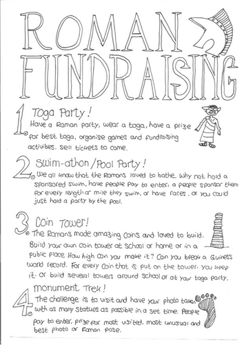
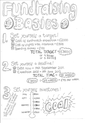
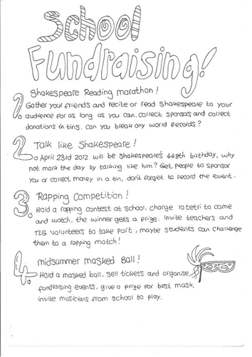
This is a hand written resource that I created for my class in the former Soviet Republic of Georgia, so they could raise funds for an expedition they were planning. The theme was the 'Romans' and would help them to work in groups to organise the fundraising events and to raise the budget they needed for their school trip. There are 19 fundraising activities for students, some simple, some requiring a bit more input. Please note that there are some references to our local currency (GEL) and a couple of people or places that we had connections with, but you could easily substitute these for your local currency, people, or places.
Please leave me a review and I will send you any other resource of your choice for free (contact me: office@oceansproject.com). Check out my other resources at my shop: https://www.tes.com/teaching-resources/shop/sarah277
Let me know if you have any resource requests and I will tailor make a resource for you.
This is a hand written resource that I created for my class in the former Soviet Republic of Georgia, so they could raise funds for an expedition they were planning. The theme was 'journeys' and would help them to work in groups to organise the fundraising events and to raise the budget they needed for their school trip. There are 13 activities for students, some simple, some requiring a bit more input. Please note that there are some references to our local currency (GEL) and a couple of people or places that we had connections with, but you could easily substitute these for your local currency, people, or places.
Please leave me a review and I will send you any other resource of your choice for free (contact me: office@oceansproject.com). Check out my other resources at my shop: https://www.tes.com/teaching-resources/shop/sarah277
Let me know if you have any resource requests and I will tailor make a resource for you.
This is a hand written resource that I created for my class in the former Soviet Republic of Georgia, so they could raise funds for an expedition they were planning. This would help them to work in groups, to organise the fundraising events, and to raise the budget they needed for their school trip. There are 72 fundraising activities for students, some simple, some requiring a bit more input. Please note that there are some references to our local currency (GEL) and a couple of people or places that we had connections with, but you could easily substitute these for your local currency, people, or places.
Please leave me a review and I will send you any other resource of your choice for free (contact me: office@oceansproject.com). Check out my other resources at my shop: https://www.tes.com/teaching-resources/shop/sarah277
Let me know if you have any resource requests and I will tailor make a resource for you.
A colouring page that I created for my students as part of a geography module on coastal invasion and settlement. This picture is of Fort Clonque on the British Channel Island of Alderney.
"Fort Clonque is a 19th-century coastal fortress in Alderney, in the Bailiwick of Guernsey in the Channel Islands. It was constructed at a time when French naval power was becoming an increasing concern to the British". (Wikipedia)
Please leave me a review and I will send you any other resource of your choice for free (contact me: office@oceansproject.com). Check out my other resources at my shop: https://www.tes.com/teaching-resources/shop/sarah277
Let me know if you have any resource requests and I will tailor make a resource for you.
A colouring page that I drew for my geography students as part of a module on coastal defence. Based on the coastal defences of Alderney in the British Channel Islands.
"Braye Harbour (also known as Alderney Harbour) is the main harbour on the north side of the Island of Alderney, in the Channel Islands, a dependency of the British Crown. A 3,000 feet (910 m) break-water built by the Admiralty to protect the Navy in the 19th century shelters Braye Harbour.[1][2][3] It is an artificial harbour created by building a pier or jetty. The harbour faces out onto the Swinge, which is part of the English Channel. It is here that most of the island's freight comes in. It is more or less a suburb of St Anne, which is a large settlement in Alderney that juts out on a rocky promontory on the west side, approximately 1 mile from the harbour". (Wikipedia)
Please leave me a review and I will send you any other resource of your choice for free (contact me: office@oceansproject.com). Check out my other resources at my shop: https://www.tes.com/teaching-resources/shop/sarah277
Let me know if you have any resource requests and I will tailor make a resource for you.
A colouring page that I created as part of a topic on settlements and geography so that my students could compare the similarities and differences between hamlets, villages, towns, and cities. The picture is of Victoria Street on the British Channel Island of Alderney, which has a population of 1000 and just one street in the town. The street was named after Queen Victoria.
Please leave me a review and I will send you any other resource of your choice for free (contact me: office@oceansproject.com). Check out my other resources at my shop: https://www.tes.com/teaching-resources/shop/sarah277
Let me know if you have any resource requests and I will tailor make a resource for you.
An A4 page in black and white, that I created for my students as part of a biology lesson on adaptation to the environment.
Themes:
- Seaside
- Coast
- Ocean
- Animals
- Habitat and Ecosystems
- Nature and Wildlife
- Flight
Please leave me a review and I will send you any other resource of your choice for free (contact me: office@oceansproject.com). Check out my other resources at my shop: https://www.tes.com/teaching-resources/shop/sarah277
Let me know if you have any resource requests and I will tailor make a resource for you.
A Key Stage 1 (age 6-7) Science resource based around the ocean. I created this for my class as part of our oceans, seas, and animals modules.
Please leave me a review and I will send you any other resource of your choice for free (contact me: office@oceansproject.com). Check out my other resources at my shop: https://www.tes.com/teaching-resources/shop/sarah277
Let me know if you have any resource requests and I will tailor make a resource for you.
A colouring page that I created for my class as part of a geography and biology class on the ocean and shellfish, and shells being used in art and decoration. The shells are called Ormer on the British Channel Islands and are a local delicacy, in the USA they are known as abalone.
Please leave me a review and I will send you any other resource of your choice for free (contact me: office@oceansproject.com). Check out my other resources at my shop: https://www.tes.com/teaching-resources/shop/sarah277
Let me know if you have any resource requests and I will tailor make a resource for you.
A colouring sheet that I created to help my students understand the meaning of a century, and what we mean by the 1st century, 2nd century, etc.
Please leave me a review and I will send you any other resource of your choice for free (contact me: office@oceansproject.com). Check out my other resources at my shop: https://www.tes.com/teaching-resources/shop/sarah277
Let me know if you have any resource requests and I will tailor make a resource for you.
A hand drawn colouring in page that I created for my students as part of a lesson on Viking Age Britain in the year 789AD. Looks at the Kings and Kingdoms of England at the time of the Viking’s first invasion in the year 789AD on the Isle of Portland on the south coast. Could be used in a module about Vikings, Anglo Saxons, or for local knowledge on the Isle of Portland on the south coast of England.
I created this colouring page for my students, as part of our history and geography modules as we learnt about the Vikings in Britain, and barrier beaches.
Please leave me a review and I will send you any other resource of your choice for free (contact me: office@oceansproject.com). Check out my other resources at my shop: https://www.tes.com/teaching-resources/shop/sarah277
Let me know if you have any resource requests and I will tailor make a resource for you.
I created this page for my class as part of our module on quarrying. It is based on the quarries in Portland, on the south coast of England. Focusing on the advantages and disadvantages of quarries.
Other National Curriculum Elements:
- Local knowledge about Portland (geography)
- Vikings
- barrier beach, bar, tombolo
- limestone
Please leave me a review and I will send you any other resource of your choice for free (contact me: office@oceansproject.com). Check out my other resources at my shop: https://www.tes.com/teaching-resources/shop/sarah277
Let me know if you have any resource requests and I will tailor make a resource for you.
What do we mean by ‘Norsemen’? The word Norsemen means ‘men of the North’. Also covered briefly on this sheet: use of the word ‘country’, ‘kingdom’, points of a compass, and the meaning of ‘Scandinavia’.
A photocopiable printout, hand out, or worksheet that students can colour in and highlight as they learn about Vikings, history, and geography. Suitable for all ages as a stand alone sheet or part of a wider topic.
A hand drawn page that I created for my students as part of our module on quarrying and sustainable management. We looked at the quarries on the Isle of Portland on the south coast of England.
Other National Curriculum Elements:
- Local knowledge about Portland (geography)
- Vikings
- barrier beach, bar, tombolo
- limestone
- sustainability
- resource management
Please leave me a review and I will send you any other resource of your choice for free (contact me: office@oceansproject.com). Check out my other resources at my shop: https://www.tes.com/teaching-resources/shop/sarah277
Let me know if you have any resource requests and I will tailor make a resource for you.
A worksheet that students can colour in as they learn about the planet where we live. Suitable for a range of ages. Can be given as homework, revision, fun, or as part of the lesson.
A Christmas colouring activity to get your class into the festive spirit. A robin in a holly tree. Perfect for the days when it is too cold to play outside at break. Could also be used as inspiration for writing a story or for a unit on animals and habitats.
Please leave me a review and I will send you any other resource of your choice for free (contact me: office@oceansproject.com). Check out my other resources at my shop: https://www.tes.com/teaching-resources/shop/sarah277
Let me know if you have any resource requests and I will tailor make a resource for you.