Thank you for visiting! Here you will find a selection of printable, interactive worksheets for your classroom: Basic Geography worksheets with simple maps, ESL, Spanish, Bible, Reading Comprehension and more. I hope you find the resources useful! Reviews are welcome and very much appreciated. Thank you so much.
Thank you for visiting! Here you will find a selection of printable, interactive worksheets for your classroom: Basic Geography worksheets with simple maps, ESL, Spanish, Bible, Reading Comprehension and more. I hope you find the resources useful! Reviews are welcome and very much appreciated. Thank you so much.
Introduce your learners to the United States Virgin Islands with two printable handouts (plus answer key). Your students will read a brief introduction to the U.S. Virgin Islands (location, capital, flag, language), write ‘Charlotte Amalie’ next to the star on the map to show the location of the capital, locate and circle the U.S. Virgin Islands on the map of the Caribbean, color the map, and use the reading passage, maps and compass to answer 9 true/false questions on page 2. Colored pencils and a pen or pencil are needed for this activity. No other prep needed. Basic Geography worksheet with a simple map to introduce the U.S. Virgin Islands and practice cardinal and ordinal directions. Print and Go!
For use with Interactive Notebooks: After the worksheets are completed, students can cut out the map and flag and paste into the notebook under the topic of (example) The Caribbean / Sub-topic: United States Virgin Islands. Under the map, your students can write a summary in their own words of what they now know about this country. Collect worksheets of other countries of the Caribbean to add to the notebook! All available in this store!
Thank you so much for using my Geography worksheets in your classroom! I hope you find them useful. Reviews are welcome and very much appreciated! Please follow me for more worksheets to introduce your learners to the countries of the world!
SPED, Resource Room Teacher, Primary school, elementary, reading comprehension
Introduce your students to the state of New York with two worksheets (plus answer key). Your students will read a brief introduction to New York (location, capital, state flag, state bird, state flower), write ‘Albany’ next to the star on the map to show the location of the capital, color the small map, state bird and flower, and use the map and compass to answer 8 questions on page 2. Colored pencils and a pen or pencil are needed for this activity. No other prep needed. Basic Geography worksheet with a simple map to introduce New York and practice cardinal and ordinal directions.
For use with Interactive Notebooks: After the worksheets are completed, students can cut out the map, flag, state bird and flower, and paste it into the notebook under the topic of United States/Sub-Topic New York. Under the map, students can write a summary in their own words of what they now know about this state. Collect worksheets for other states of the USA to add to the notebook! Please browse this store for a selection of worksheets for other states of the USA (and beyond!)
Thank you so much for using my worksheets in your classroom! Reviews are welcome and very much appreciated.
Learn about New York with this bundle of printable Geography handouts:
New York: 2 worksheets (plus answer key). Your students will read a brief overview of New York (location, capital, state bird, state flower, abbreviation), write ‘Albany’ next to the star on the map to show the capital of New York, color a small map and then use the map and compass to answer 8 questions.
Long Island: 2 worksheets (plus answer key). Your students will read a brief overview of Long Island, color a small map, and use the map and compass to answer 8 questions. Map includes Suffolk County, Nassau County, Queens and Brooklyn, separated by the Bronx and Manhattan by the East River. Atlantic Ocean, Long Island Sound, Hudson River, The Hamptons, North Fork, South Fork, Montauk.
Northeastern Region of the United States: 2 worksheets (plus answer key). This list includes 11 states: The states of New England: Maine (ME), New Hampshire (NH), Vermont (VT), Massachusetts (MA), Rhode Island (RI), and Connecticut (CT), and the Middle States: New York (NY), Pennsylvania (PA), New Jersey (NJ) and Delaware (DE). Your students will write the full name of each state on the map, then color the six states of New England one color and the middle states another color. Then they will use the map and compass to answer six questions.
Color the map of the United States: 1 printable handout with map to color.
For use with Interactive Notebooks: After the handout is completed and the map is colored and questions are answered, cut out the map and paste it into the notebook under the topic of United States / sub-topic New York. Under the map, students will write a summary in their own words of what they now know about the state/region.
Introduce your students to Long Island, New York with this printable handout of 2 worksheets (plus answer key). Your students will read a brief introduction to Long Island, New York, color the small map, and use the map and compass to answer 8 questions on page 2. Answer key included.
Map includes Suffolk County, Nassau County, Queens and Brooklyn, separated by the Bronx and Manhattan by the East River. Atlantic Ocean, Long Island Sound, Hudson River, The Hamptons, North Fork, South Fork, Montauk.
Thanks so much for using my worksheets in your classroom! I hope you find them useful. Reviews are welcome and very much appreciated! Please browse this store for more worksheets to introduce your learners to the countries of the world!
Fill in the blank of each sentence with the correct contraction. Printable handout of 2 worksheets with 10 sentences on each page.
Contractions included:
Page 1:
I would = I’d
She would = She’d
He would = He’d
They would = They’d
You would = You’d
I am = I’m
She is = She’s
He is = He’s
They are = They’re
You are = You’re
Page 2:
I will = I’ll
She will = She’ll
He will = He’ll
They will = They’ll
You will = You’ll
do not = don’t
does not = doesn’t
will not = won’t
did not = didn’t
should not = shouldn’t
Thank you for using my printable worksheets in your classroom! I hope you find them useful. Reviews are welcome and very much appreciated!
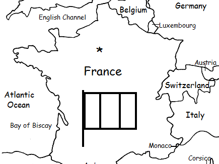
Introduce your students to France with this printable handout of two worksheets (plus answer key). Your students will read a brief introduction to France (location, capital, flag, language), write ‘Paris’ next to the star on the map to show the location of the capital, color the small map and flag, and use the map and compass to answer 7 questions on page 2. Colored pencils and a pen or pencil are needed for this activity. No other prep needed. Basic geography worksheet includes a simple map to introduce France and practice cardinal/ordinal directions.
For use with Interactive Notebooks: After completing the worksheets, students can cut out the map and flag and paste it into the notebook under the topic of Europe/Sub-Topic: France. Under the map and flag, students can write a summary in their own words of what they now know about France. Collect worksheets for other countries of Europe to add to the notebook! Please browse this store for a selection of worksheets for other countries of Europe (and beyond!).
Thank you so much for using my Geography worksheets in your classroom! Reviews are welcome and very much appreciated.
Included on map: Belgium, Luxembourg, Germany, Switzerland, Italy, Monaco, Andorra, Spain, Corsica, United Kingdom, Netherlands, Austria, North Sea, English Channel, Bay of Biscay, Mediterranean Sea, Atlantic Ocean.
Introduce your learners to CHINA with this printable handout of two worksheets (plus answer key). Your students will read a brief introduction to China (location, capital, language, flag), write ‘Beijing’ next to the star on the map to show the location of the capital, color the flag and map, and use the map and compass to answer 10 questions on page 2. Colored pencils and a pen or pencil are needed for this activity. No other prep needed. Basic Geography worksheet with a simple map to introduce China and practice cardinal/ordinal directions.
For use with Interactive Notebooks: After your students complete the worksheets, they can cut out the map and paste into the notebook under the topic Asia/Sub-topic: China. Under the map, your students can write a summary in their own words of what they now know about China. Collect worksheets for other countries of Asia to add to the notebook! Please browse this store for a selection of printable Geography worksheets for other countries of Asia (and beyond!).
Thank you so much for using my Geography worksheets in your classroom! I hope you find them useful! Reviews are welcome and very much appreciated.
Notes: China shares land borders with 14 countries: Vietnam, Laos, Myanmar,
India, Bhutan, Nepal, Afghanistan, Pakistan, Tajikistan,
Kyrgyzstan, Kazakhstan, Russia, Mongolia, and North Korea. Pacific Ocean.
Introduce your students to Puerto Rico with this printable handout of two worksheets (plus answer key). Your students will read a brief introduction to Puerto Rico (location, capital, flag, language), write ‘San Juan’ next to the star on the map to show the location of the capital, color the small map and flag, and use the map and compass to answer 6 questions on page 2. Colored pencils and a pen or pencil are needed for this activity. No other prep needed.
For use with Interactive Notebooks: After the worksheets are completed, students can cut out the map and flag of Puerto Rico and paste into the notebook. Under the map and flag, students can write a summary in their own words of what they now know about Puerto Rico. Collect worksheets for other countries to add to the notebook! Please browse this store for a selection of worksheets for Caribbean Islands, Spanish-speaking countries, and beyond!
Thank you so much for using my Geography worksheets in your classroom! I hope you find them useful. Reviews are welcome and very much appreciated!
Included on map of Puerto Rico and surrounding: Atlantic Ocean, Caribbean Sea, Mona, Culebra, Viequez, Desecheo, Florida, Dominican Republic, Haiti, Cuba. Cardinal, ordinal directions.
Introduce your students to IRAQ with this printable handout of two worksheets (plus answer key). Your students will read a brief introduction to Iraq (location, capital, flag, language), write ‘Baghdad’ next to the star on the map to show the capital, color the small flag and map, and use the map and compass to answer 9 questions on page 2. Colored pencils and a pen or pencil are needed for this activity. No other prep needed. Basic Geography worksheet with a simple map to introduce Iraq and practice cardinal and ordinal directions.
For use with Interactive Notebooks: After the worksheets are completed, students can cut out the map and flag and paste into the notebook under the topic of Asia / Sub-Topic: Iraq. Under the map, students can write a summary in their own words of what they now know about this country. Collect worksheets for other countries of Asia to add to the notebook! Please browse this store for worsheets for all other countries of Asia (and beyond!).
Thank you so much for using my Geography worksheets in your classroom! I hope you find them useful. Reviews are welcome and very much appreciated!
Tigris River, Euphrates River, Cardinal, Ordinal directions.
Introduce your students to EQUATORIAL GUINEA with two worksheets (plus answer key). Your students will read a brief introduction to Equatorial Guinea (location, capital, flag, language), write ‘Malabo’ next to the star on the map to show the location of the capital, trace the dotted line to show the equator, color the small flag and map, and then use the map and compass to answer 8 questions on page 2. Pen or pencil and colored pencils needed for this activity. No other prep needed. Basic Geography worksheet with a simple map to introduce Equatorial Guinea and practice cardinal and ordinal directions.
For use with Interactive Notebooks: After the worksheets are completed, students can cut out the map and flag and paste into the notebook under the topic of Topic: Africa / Sub-Topic: Equatorial Guinea. (or Topic: Spanish-Speaking Countries / Sub-Topic: Equatorial Guinea). Under the map, your students can write a summary in their own words of what they now know about this country. Collect worksheets for other countries of Africa or Spanish-speaking countries to add to the notebook! Please browse this store for worksheets for other countries!
Thank you so much for using my Geography worksheets in your classroom! Reviews are welcome and very much appreciated.
Africa, Spanish, Gulf of Guinea, cardinal, ordinal directions.
Introduce your students to Suffolk County, Long Island, New York with this printable handout of two worksheets (plus answer key). Your students will read a brief introduction to Suffolk County, study the small map, trace the lines to show Sunrise Highway and the Long Island Expressway, color the Great South Bay, Atlantic Ocean and other surrounding bodies of water blue, and use the map and compass to answer 12 questions on page 2. Answer key included.
For use with Interactive Notebooks: After the worksheets are completed, students can cut out the map and paste into the notebook under the topic of United States / New York / Sub-Topic: Long Island. Under the map, students can write a summary in their own words of what they now know about Suffolk County. Add maps from other worksheets to the notebook! Please browse this store for worksheets to introduce your students to the 50 states of the USA and the countries of the world!
Thank you so much for using my Geography worksheets in your classroom! I hope you find them useful. Reviews are welcome and very much appreciated!
Introduce your learners to the US state of TEXAS with two worksheets (plus answer key). Your students will read a brief introduction to Texas (location, capital, flag, state bird and state flower), write ‘Austin’ next to the star on the map to show the location of the capital, color the small map, state bird and state flower, and use the map and compass to answer 7 questions on page 2. Colored pencils and a pen or pencil are needed for this activity. No other prep needed. Basic Geography worksheet with a simple map to introduce Texas and practice cardinal and ordinal directions.
For use with Interactive Notebooks: After the worksheets are completed, students can cut out the map, flag, state bird and state flower, and paste into the notebook under the topic of United States/Sub-Topic: Texas. Under the map, students can write a summary of what they now know about this state. Collect worksheets for all states to add to the notebook! Please browse this store for worksheets for other states of the USA (and beyond!)
Thank you so much for using my Geography worksheets in your classroom! I hope you find them useful. Reviews are welcome and very much appreciated.
State bird: Northern Mockingbird
State flower: Bluebonnet
Introduce your students to the U.S. state of Georgia with this printable handout of two worksheets (plus answer key). Your students will read a brief introduction to Georgia (location, capital, flag, state bird and flower), write ‘Atlanta’ next to the star on the map to show the location of the capital, color the small map, state bird and flower, and use the map and compass to answer 7 questions on page 2. Colored pencils and a pen or pencil are needed for this activity. No other prep needed. Basic Geography worksheet with a simple map to introduce the state of Georgia and practice cardinal and ordinal directions.
For use with Interactive Notebooks: After the worksheets are completed, students can cut out the map, flag, state bird and state flower, and paste into the notebook under the topic of United States / Sub-Topic: Georgia. Under the map, students can write a summary in their own words of what they now know about this state. Collect worksheets for all U.S. states to add to notebook! Please browse this store for a selection of worksheets for other states of the USA (and beyond!)
Thank you so much for using my Geography worksheets in your classroom! I hope you find them useful. Reviews are welcome and very much appreciated.
Introduce your students to Slovakia with two worksheets (plus answer key). Your students will read a brief introduction to Slovakia (location, capital, flag, language), write ‘Bratislava’ next to the star on the map to show the location of the capital, color the small map and flag, and use the map and compass to answer 6 questions on page 2. Colored pencils and a pen or pencil are needed for this activity. No other prep needed. Basic Geography worksheet with a simple map to introduce Slovakia and practice cardinal and ordinal directions.
For use with Interactive Notebooks: After the worksheets are completed, students can cut out the map and flag and paste into the notebook under the topic of Europe / Sub-Topic: Slovakia. Under the map and flag, your students can write a summary in their own words of what they now know about this country. Collect worksheets for other countries of Europe to add to notebook! Please see this store for a list of worksheets for other countries of Europe (and beyond!).
Thank you so much for using my Geography worksheets in your classroom! I hope you find them useful. Reviews are welcome and very much appreciated!
Introduce your students to PORTUGAL with two worksheets (plus answer key). Your students will read a brief introduction to Portugal (location, capital, flag, language), write ‘Lisbon’ next to the star on the map to show the location of the capital, color the small flag and map, and use the map and compass to answer 6 questions on page 2. Colored pencils and a pen or pencil are needed for this activity. No other prep needed. Basic Geography worksheet with a simple map to introduce Portugal and practice cardinal and ordinal directions.
For use with Interactive Notebooks: After completing the worksheets, students can cut out the map and flag and paste into the notebook under the topic of Europe / Sub-Topic: Portugal. Under the map and flag, students can write a summary in their own words of what they now know about this country. Collect worksheets for other countries of Europe to add to the notebook! Please browse this store for worksheets for other countries of Europe (and beyond!).
Thank you so much for using my Geography worksheets in your classroom. I hope you find them useful! Reviews are welcome and very much appreciated.
Introduce your learners to CROATIA in Europe with two worksheets (plus answer key). Your students will read a brief introduction to Croatia (location, capital, flag, language), write ‘Zagreb’ next to the star on the map to show the capital, color the small map, and use the map and compass to answer 7 questions on page 2. Colored pencils and a pen or pencil are needed for this activity. No other prep needed. Basic Geography worksheet with a simple map to introduce the country of Croatia and practice cardinal and ordinal directions.
For use with Interactive Notebooks: After completing the worksheets, students can cut out the map and flag of Croatia and paste into the notebook under the topic of Europe / Sub-Topic: Croatia. Under the map and flag, students can write a summary in their own words of what they now know about this country. Collect worksheets for other countries of Europe to add to the notebook! Please browse this store for a selection of worksheets for other countries of Europe (and beyond!)
Thank you so much for using my Geography worksheets in your classroom! I hope you find them useful. Reviews are welcome and very much appreciated.
Map includes: Adriatic Sea, Slovenia, Hungary, Austria, Serbia, Bosnia and Herzegovina, Montenegro, Italy
Flag includes Coat of arms: šahovnica. 5 Croatian regions: Croatia, Dubrovnik, Dalmatia, Istria, and Slavonia.
Introduce your learners to LATVIA with two worksheets (plus answer key). Your students will read a brief introduction to Latvia (location, capital, flag, language), write ‘Riga’ next to the star on the map to show the location of the capital, color the small flag and map, and use the map and compass to answer 7 questions on page 2. Colored pencils and a pen or pencil are needed for this activity. No other prep needed. Basic Geography worksheet with a simple map to introduce Latvia and practice cardinal and ordinal directions.
For use with Interactive Notebooks: After completing the worksheets, students can cut out the map and flag and paste into the notebook under the topic of Europe / Sub-Topic: Latvia. Under the map and flag, students can write a summary in their own words of what they now know about Latvia. Collect worksheets for other countries of Europe to add to the notebook! Please browse this store for worksheets for other countries of Europe (and beyond!).
Thank you so much for using my Geography worksheets in your classroom! Reviews are welcome and very much appreciated.
Baltic Region
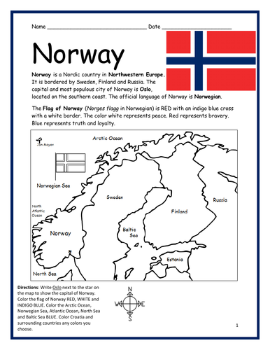
Introduce your learners to NORWAY with this two worksheets (plus answer key). Your students will read a brief introduction to Norway (location, capital, flag, language), write ‘Oslo’ next to the star on the map to show the location of the capital, color the small flag and map, and use the map and compass to answer 6 questions on page 2. Colored pencils and a pen or pencil are needed for this activity. No other prep needed. Basic Geography worksheet with a simple map to introduce Norway and practice cardinal and ordinal directions.
For use with Interactive Notebooks: After completing the worksheets, students can cut out the map and flag of Norway and paste into the notebook under the topic of Europe / Sub-Topic: Norway. Under the map and flag, students can write a summary in their own words of what they now know about this country. Collect worksheets for other countries of Europe to add to the notebook! Please browse this store for worksheets for other countries of Europe (and beyond!).
Thank you so much for using my Geography worksheets in your classroom! Reviews are welcome and very much appreciated.
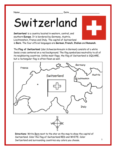
Introduce your students to SWITZERLAND with two interactive worksheets (plus answer key). Your students will read a brief introduction to Switzerland (location, capital, flag, language), write ‘Bern’ next to the star on the map to show the location of the capital, color the small flag and map, and use the map and compass to answer 6 questions on page 2. Colored pencils and a pen or pencil are needed for this activity. No other prep needed. Basic Geography worksheet with a simple map to introduce Switzerland and practice cardinal/ordinal directions.
For use with Interactive Notebooks: After completing the worksheets, students can cut out the map and flag and paste into the notebook under the topic of Europe/Sub-Topic: Switzerland. Under the map and flag, students can write a summary in their own words of what they now know about Switzerland. Collect worksheets for other countries of Europe to add to notebook! Please browse this store for worksheets for other countries of Europe (and beyond!).
Thank you so much for using my Geography worksheets in your classroom! Reviews are welcome and very much appreciated.