The author grew up near the birthplace of the famous cartographer Gerard Mercator. Inspired by this great scientist and artist he went to study Physical Geography (BSc), Cartography (Masters) and Remote Sensing (Postgraduate). This website and its products are the result of more than 40 years of experience in Cartography, GIS and IT, both as a teacher and developer. He suffers from a form of ASD (Autism), which was only diagnosed at a late age. Please visit his Blogspot for more information.
The author grew up near the birthplace of the famous cartographer Gerard Mercator. Inspired by this great scientist and artist he went to study Physical Geography (BSc), Cartography (Masters) and Remote Sensing (Postgraduate). This website and its products are the result of more than 40 years of experience in Cartography, GIS and IT, both as a teacher and developer. He suffers from a form of ASD (Autism), which was only diagnosed at a late age. Please visit his Blogspot for more information.
New Zealand in 30 historical maps: 1642-2018 (106 pages).
New Zealand is named after the province of Zeeland in the Netherlands, which means “sea land”, referring to the large number of islands it contains. Abel Tasman, the first European explorer reaching the country in 1642, referred to New Zealand as Staten Landt. But later Dutch cartographers used Zeelandia Nova (Latin), followed by Nieuw-Zeeland in Dutch. Aotearoa has become the most common name for the country in the indigenous Maori language, meaning “land of the long white cloud”. After Tasman’s discovery of NZ, parts of its Western coastline appeared for the first time on the famous world (wall) map of the Blaeu family in 1648. It was assumed that the North- and South Island were connected. It took more than 100 years until the whole coastline was mapped, after Captain Cook had circumnavigated the country.
Australia in 39 historical maps: 1547-2018 (124 pages).
The name Australia is adapted from the Latin name Terra Australis Incognita, meaning the “Unknown Southern Land”. The name was used on 16th century world maps, e.g. the ones of Mercator and Ortelius, to identify a large imaginary landmass stretching around the south pole. The present day country and continent became officially known as Australia in 1824, after the British explorer Matthew Flinders had circumnavigated the island 20 years earlier and introduced the name in his charts and publications. Before this, the Latin name Hollandia Nova (New Holland) was mostly used to identify present day Australia. The name was introduced by Dutch explorers who had discovered the West coast in the early 17th century. It appeared - for the first time - on the large world map of the Blaeu firm in 1648, and later in their printed Atlas Maior from 1662 onwards.
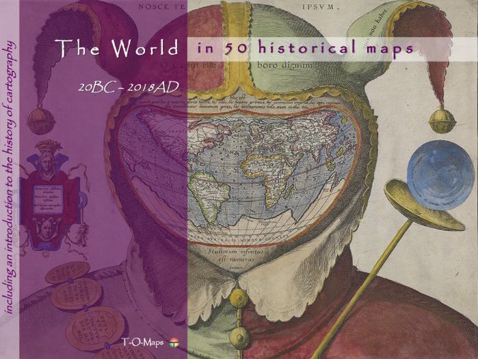
This world atlas comprises 50 carefully selected world maps plus a description of their makers. Furthermore it includes a comprehensive insight in the history of cartography and how and why maps are/were made. The e-atlas shows how the world has changed through time and how map making techniques have evolved. Each era is represented by a number of maps drawn by the most famous (European) cartographers of their time. From early classical & medieval maps, via maps of 16th/17th century atlases (Golden Age of Cartography), to contemporary computer-generated images.
Besides this world atlas, e-atlases of the 6 continents and separate e-atlases of more than 50 countries, distributed all over the world, are currently available. The provided e-atlases are not meant to replace the traditional printed atlases but are an addition and offer extra functionality (e.g. zooming in on geographic features). They can be downloaded as PDF-files; the files can be viewed using Acrobat Reader (version 10 or higher) and compatible applications.
Each historical e-atlas is composed of 4 sections. The first 3 sections describe the history of cartography and map making techniques in general. In the 4th or major section (Country maps and their Makers) the history of a specific country is visualized via a range of maps from important mapmakers in different era’s. The document is made up of duo pages; the right page displays the map of a given period, the left page contains text describing its creator and other details. Each atlas also includes an Appendix which contains a selection of common Latin terms that are used on ancient maps.
The historical e-atlases are suitable for reading and presentation purposes (in classrooms). The maps and their descriptions can be studied and printed at home or school. The main group of potential users are teachers and students in geography and history. Moreover, the atlases are useful to anyone who is interested in old maps of his/hers native or ancestors country.
For more (background) information please refer to the author’s Blogspot:
https://tomaps20.blogspot.com/
The name **Africa **may be derived from the Phoenician word afar, meaning “dust”. The name Africa Terra (“Land of the dust”) was introduced by the ancient Romans to identify the northern part of the continent that corresponds to modern-day Tunisia. (Northern) Africa was already described by classical Greek scholars; e.g. Ptolemy in his Geographia (150AD). The accompanying (world) maps were worked out again by European cartographers at the end of the 15th century. It is also depicted on the T-O based Mappa Mundi of the middle ages, being one of the 3 then known ‘old’ continents (besides Asia and Europe). During the Middle Ages, as the Europeans increased their knowledge and awareness of the size of the African continent, they progressively extended the name of Africa to the rest of the continent. Waldseemuller’s large map of 1507 - being partly based on Ptolemy’s ideas and new discoveries - was one of the first world maps depicting the whole continent, including the South-African coastline. On the earlier world map of Martellus (1490) the southern part was truly out of shape; on Cantino’s portolan chart (1502) it was corrected on account of information provided by Portuguese explorers. The first (printed) separate maps of Africa appeared in the mid 16th century. At first they were small overview maps in pocket atlases. Numerous large atlas maps made by famous cartographers would follow: e.g. Lafreri (Italy), Mercator (Belgium), Speed (England), Sanson (France), Blaeu (Netherlands) and Homann (Germany).
In classical Greek mythology, Europe (Europa) is the name of either a queen of Crete or Phoenician princess. It means “wide-gazing” or “broad of aspect”. Europe was already described by classical Greek scholars; e.g. Ptolemy in his Geographia (150AD). The accompanying maps were worked out again by European cartographers at the end of the 15th century. It is also depicted on the T-O based Mappa Mundi of the middle ages, being one of the 3 then known ‘old’ continents (besides Asia and Africa). The first (printed) separate maps of Europe appeared in the early 16th century. Numerous maps made by famous cartographers would follow: e.g. Gastaldi (Italy), Mercator (Belgium), Speed (England), Sanson (France), Blaeu (Netherlands) and Homann (Germany).
Canada in 47 historical maps: 1507-2018 (140 pages).
The name Canada is derived from the Algonquin word Kanada, which means “village”. The name appeared for the first time on French world maps in about 1540. The name Quebec was used on early maps to identify newly discovered parts of Canada. The name was introduced by the French explorer Samuel de Champlain in 1608. The name Quebec is derived from the Algonquin word kébec, meaning “where the river narrows”. (Referring to the St. Lawrence River near modern Quebec City.) The name Canada originally only referred to a small area being part of a larger Eastern region called Nova Francia (in Latin), after it had been colonized by the French. After their independence from the UK, in 1867, the name Canada was soon adopted for the whole country as we know it today. The first separately printed maps of Canada did appear not until the 19th century.
China in 45 historical maps: 1137-2018 (140 pages).
The most commonly theory suggests that the name China refers to the Qin dynasty, which ruled China from 221 till 206 BC. The name China was adopted by Martino Martini and other 17th century (European) cartographers. On earlier maps the name Cathay, based on Marco Polo’s Italian name Catai, was used to identify the northern part of present-day China. The (eastern) coastline of China was not yet depicted on early European (world) maps based on Ptolemy’s descriptions. The large wall maps of Cresques (1375) and Fra Mauro (1450) were the first European world maps showing the extent of China to the east. On the other hand, a few centuries earlier, Chinese cartographers had already produced some remarkably accurate maps - at the time - of China and surroundings. The first separate maps of China, printed by Europeans, appeared in the 16th century.
Argentina and Chile in 44 historical maps: 1536-2018 (134 pages).
The name Argentina refers to the Río de la Plata (Latin: Argenteus), meaning “Silver River”. It was given by the explorer Sebastian Cabot in the 1520s after acquiring some silver trinkets from a local tribe (the Guaraní). The origin of the name Chile is uncertain. It may be derived from the Mapuche word Chili , meaning “where the land ends”. (The Mapuche are a group of indigenous inhabitants of south-central Chile and south-western Argentina, including parts of the region Patagonia.) The name Patagonia (Patagão), covering large parts of present-day Argentina and Chile, was introduced by the Portuguese explorer Ferdinand Magellan (1519-1522 voyage). It means “Land of big feet” referring to the huge people he reported to have seen. The first maps of Argentina and Chile resembling the modern maps nowadays did not appear until the midst of the 19th century. This was after their independence from Spain in 1810 (Chile) and 1816 (Argentina).
Brazil in 46 historical maps: 1502-2018 (138 pages).
The name Brazil or Terra do Brasil was introduced by Portuguese explorers. It is derived from pau-brasil, meaning “red-wood”. The word refers to a kind of timber which can be found scattered across the country. The similar Latin word brasa also refers to red-hot embers. The eastern coastline of Brazil - and (South) America in general - appeared for the first time on the world map of Alberto Cantino in 1502 and earlier on the manuscript map of Juan de la Cosa in 1500. The large world map of Martin Waldseemuller in 1507 was the first printed map that incorporated the new discovered land. The name America appeared on the map identifying the new discovered land. After realizing that Columbus - and not Amerigo Vespucci - had discovered the new continent, Waldseemuller changed the name in “Terra Incognita” on his later maps (e.g. in his atlas published in 1513).
Austria in 41 historical maps: 1513-2018 (128 pages).
Austria (German Österreich) means “Eastern March”. In Medieval times it was named in Latin: Marchia Orientalis. It is a former eastern prefecture of the Duchy of Bavaria, established in 976. The borders of Austria would change numerous times in the course of history, as shown on the maps in this atlas. In ca. 1560 the first separately printed map was published by the Hungarian cartographer Lazius. His map was used by famous cartographers, among them: Ortelius, Mercator and the Blaeu family.
The name Asia comes from Semitic, an old language from which the current Arabic, Hebrew and Maltese languages, among others, are derived. It refers to the word asu, which means “rising of the sun”. (Western) Asia was already described by classical Greek scholars; e.g. Ptolemy in his Geographia (150AD). The accompanying (world) maps were worked out again by European cartographers at the end of the 15th century. It is also depicted on the T-O based Mappa Mundi of the middle ages, being one of the 3 then known ‘old’ continents (besides Africa and Europe). During the Middle Ages, as the Europeans increased their knowledge and awareness of the size of the Asian continent, they progressively extended the name of Asia to the rest of the continent. Waldseemuller’s large map of 1507 - being partly based on Ptolemy’s ideas and new discoveries - was one of the first printed world maps depicting the whole continent, including the far eastern coastline. The first ‘complete’ maps of Asia were still largely based on the voyages of discovery that the Venetian merchant Marco Polo had made between 1271 and 1295 to the Far East. The first (printed) separate maps of Asia appeared in the mid 16th century. At first they were small overview maps in pocket atlases. Numerous large atlas maps made by famous cartographers would follow: e.g. Lafreri (Italy), Mercator (Belgium), Speed (England), Sanson (France), Blaeu (Netherlands) and Homann (Germany).
Germany in 47 historical maps: 150AD-2018 (140 pages).
The name Germany and other similar names are all derived from the Latin word Germania. Julius Caesar was the first to use the word Germanus in his writings when describing tribes in north-eastern Gaul (region stretching out from present-day France). However, its origin remains uncertain. Some (German) historians suggest that the word has Celtic roots. E.g. it may be derived from: gair (neighbour), gar (“noisy”, referring to the tribesman) or hari (“man at arms”). In English-speaking regions, the word German first appeared in about1520, replacing earlier uses of Alman and Dutch. Germany was already described by Ptolemy in his Geographia (150AD). The accompanying maps were worked out again by European cartographers at the end of the 15th century. It is also depicted on the Mappa Mundi during the middle ages. The first printed separate maps of the country appeared in the early 16th century.
France in 46 historical maps: 1375-2018 (138 pages).
The name France refers to Land of the Franks. The name means “Land of the free People”. The name may also be derived from the word frankon (spear), one of the weapons used by its warriors. On earlier maps the Latin name Gallia (Land of the Celts) or Gaul (Land of Foreigners) was used; during the 17th century the name Francia came into use. In the oldest classical descriptions (e.g. Strabo, ca. 20BC) the name Celtica is used to identify the region covering present-day France. France was also described by Ptolemy in his Geographia (150AD). The accompanying maps were worked out again by European cartographers at the end of the 15th century. Its coastline is depicted more accurate on the Portolan charts of the late middle ages, when the Mediterranean region was a centre for navigation and trade. The first printed separate maps of France appeared in the early 16th century.
England in 42 historical maps: 1480-2018 (130 pages).
In medieval times the name England (or Latin Anglia) was often used to identify the entire island of Great Britain. It means “Land of the Angles” and refers to the Celtic people living on the island prior to the Anglo-Saxon conquest. On later maps Anglia was limited to the southern part of the Island, and Scotia (Scotland) identified the Northern part. England was already described by Ptolemy in his Geographia (150AD). The accompanying maps were worked out again by European cartographers at the end of the 15th century. The first (printed) separate maps appeared at the end of the 16th century.
Cuba in 52 historical maps: 1502-2018 (150 pages).
The origin of the name Cuba is uncertain. Most likely it is means Taino cubao (“abundant fertile land” or coabana (“great place”). On early maps of Cuba and other Caribbean islands they were called the West Indies by European cartographers. This in contrast to the East Indies of present-day SE Asia. The region appeared for the first time on the manuscript map of Juan de la Cosa (1500), who had sailed to the West together with Columbus, and the Cantino world map (1502). The first separately printed maps were published at the end of the 16th century. The capital city Havana dates back to the 16th century. Being an important sea port it was founded in 1515 by Diego Velázquez.+
+NOTE: Cuba was discovered by Columbus (1492), but only concurred on the native Indians by Velásquez in 1511.
Denmark in 44 historical maps: 1480-2018 (134 pages).
The name Denmark probably means “Flat Borderlands”. Most likely it is derived from the Proto-Indo-European word dhen (meaning “low” or “flat”) and the Old Norse words merki (“boundary”) or mork (“borderland”). Although out of shape, the country is clearly visible on the first maps based on Ptolemy’s descriptions (c.1480). It looks like an appendix North of Germany. On the famous overview map of Scandinavia, made by Olaus Magnus (1539), the border of Denmark is depicted more accurately. One of the first separate maps was included in Sebastian Munster’s encyclopaedia (1544). The first separately printed (hand-coloured) map, based on the work of the Danish Cartographer Marcus Jordan (1552), was published by Ortelius in 1570.
Greece in 47 historical maps: 20BC-2018 (140 pages).
The name Greece means “Land of the Greeks”. The Latin name as introduced by the Romans is Graecia. Its origin is uncertain but it may be derived from the Proto-Greek word grauj (‘old age’) or the Proto-Indo-European word gere (‘to grow old’). The Greeks themselves called their country Hellas. This name refers to Hellen (son of Deucalion and Pyrrha), a figure found in ancient Greek mythology. Greece was already described by Ptolemy (ca. 150 AD) and other classical Greek and Roman scholars. The coastline and their numerous small islands were mapped more accurate on Portolan charts of the 14th and 15th century. The first separately printed maps appeared in the (early) 16th century.
**Remote Sensing: how satellite images are made
(1972-date) **
This concise presentation (16 pages) shows how satellite images are generated. It focuses on Landsat, the longest running project for earth observation. The entire process is explained: from the reflected sunbeams on the earth surface to the colours on the screen.
This e-Atlas shows a series of (100) curious maps which have been made through the history of cartography. From early classical maps to contemporary computer images. Mostly they were the result of the (lack of) information available to the author drawing the map. In the past the only source for cartographers was oral and written information from merchants, seamen, explorers etc. Copying maps of (foreign) colleague cartographers, including their errors, was very common. This atlas is not just a visual tour showing the history of mapping; it also marks the most important discoveries and the advancement in technology of mankind. From inventions and applications such as the magnetic compass and the printing press to modern mapping techniques like satellite remote sensing. PART IV – the main part - contains a selection of remarkable maps and a description of their contents and makers. It starts with the earliest survived maps. The maps are not only characterized by their content based on newly available information. The cartographic drawing style has also evolved through time: from early manuscript and woodcut drawings via (copper) engravings to modern printing techniques. The timeline follows the (European) history of cartography. The maps (Part IV) are grouped according to their characteristics. From the very first hand-drawn world maps, via 16th/17th century atlas maps (Golden Age of Cartography), to contemporary computer-generated (thematic) images. Within a group they are arranged chronologically.
Most of the earliest maps are in the classic Latin language, most ‘modern’ maps are in the English language.
This concise presentation covers the steps to go through to design a structured relational database. From collecting the basic information to storing it in tables. Note: It is not a manual for operating a tool like Access. It is, however, a description of the fundamental concepts that form the basis.