I'm a Geography teacher with experience educating at various levels, ranging from mainstream schools, SEN and extra-curricular tuition. I also have experience in teaching humanities, English and PSHE topics. My resources are designed primarily as schemes of works for mainly Geographical topics with all levels considered
I'm a Geography teacher with experience educating at various levels, ranging from mainstream schools, SEN and extra-curricular tuition. I also have experience in teaching humanities, English and PSHE topics. My resources are designed primarily as schemes of works for mainly Geographical topics with all levels considered
These worksheets help students learn about the history of the Winter Palace in Russia through a wordfill exercise and develop the skill of field sketching
This 32 page booklet gives students the opportunity to explore the FIFA World Cup, Russia and their connections to geography using different Geographical themes and skills. Chapters include:
Why Is Football So Popular?
How Is Football Linked To Geography?
Who Are FIFA?
Who’s Taking Part In 2018?
Friendly Rivals
We Are Number One!
Football As An Economic Activity
Flag Crossword
Getting The Vote
What Do You Know About Russia?
Where In Russia?
Population And Nationality
Country Climate
Seeing The Sites
What Have We Borrowed?
Build A Brand
Knowing The Neighbours
Football Acrostic
How Is This Omar Linked To Football?
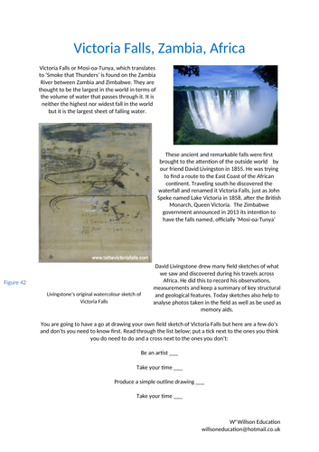
Victoria Falls or Mosi-oa-Tunya, which translates to ‘Smoke that Thunders’ is found on the Zambia River between Zambia and Zimbabwe. They are thought to be the largest in the world in terms of the volume of water that passes through it. It is neither the highest nor widest fall in the world but it is the largest sheet of falling water.
This worksheet helps your students to understand the dos and don’ts of field sketching. Victoria Falls is used as an example to help practice this important skill
These worksheets help your students to learn about the history of how Machu Picchu was discovered by the Western World and how it is used today as a tourism destination. The Inca Trail is also discussed.
Please email me at willswoneducation@hotmail.co.uk for the two videos to go with this lesson
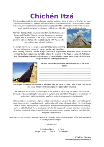
The stepped pyramids, temples, columned arcades, and other stone structures of Chichén Itzá were sacred to the Maya and a sophisticated urban centre of their empire from 750 to 1200 AD. Viewed as a whole, the incredible complex reveals much about the Maya and Toltec vision of the universe—which was intimately tied to what was visible in the night skies of the Yucatán Peninsula.
The most distinguishable structure is the Temple of Kukulkan, also known as El Castillo. This step pyramid shows the accuracy and importance of astronomy to the Maya – This influence came primarily from the Toltecs who invaded around 1000 AD and who merged their two cultural traditions.
This lesson gives your students the chance to build their own Temple Of Kukulkan and test the shadow produced to see how successful the Maya People were at producing an accurate calendar.
Using an article from The Guardian newspaper website, the students extract information on the positive and negative implications of mining uranium within the Grand Canyon. They then form their own opinion and write a persuasive speech from the point of view of the environmental campaigners or the multinational company.
Please like and follow us on Facebook @WillsonEducation or Pinterest @willsoned for more exciting resources, activities, and upcoming events to incorporate into your lessons.
The Sherpa people live in the most mountainous region of Nepal; they have become heavily influenced by Westerners who employ them while trying to conquer Mount Everest. This worksheet helps students discover the history and life of the Sherpa people. It concludes with students developing their own views on whether these influences are positive or negative.
The impacts on the mountain are discussed with the support of a newspaper article. It explores how in the past the Sherpa people have cleared some 6500 pounds of debris left behind by explorers.
The final task is to combine the information gathered and design a suitable permanent settlement at Everest Base Camp taking into consideration the views of conflicting groups and the needs of the Sherpas and visitors.
Please like and follow us on Facebook @WillsonEducation or Pinterest @willsoned for more exciting resources, activities, and upcoming events to incorporate into your lessons.
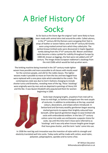
I was challenged by my sister to produce a resource about socks, challenge accepted and here it is! :-D
This booklet takes the students through how their simple socks are related to geography and the world. After a brief history of socks, they investigate where and how cotton is produced, and the production line from farmer to customer. Focusing primarily on factories in LEDCs and the working conditions, Fairtrade is examined to see how farmers are being helped with their cotton crops and how cotton works as an economic activity.
A range of individual and group activities are incorporated within this booklet, including, gathering research from print and video, drawing a story board, annotating maps, their thoughts and ideas, choropleth maps and word fills.
Please like and follow us on Facebook @WillsonEducation or Pinterest @willsoned for more exciting resources, activities, and upcoming events to incorporate into your lessons.
Rarely do volcanologists get to watch the birth, growth, and death of a volcano. Paricutin provided such an opportunity. Paricutin is a cinder cone volcano located in the state of Michoacan, Mexico. The volcano erupted on 20th February 1943, and continued to be active till 1952, during which it destroyed the villages of Parícutin and San Juan Parangaricutiro.
Dionisio Pulido and his wife Paula witnessed the volcanoes birth. Using the information given, the students are tasked to write their memories about that extraordinary day from the Mexicans point of view.
Please like and follow us on Facebook @WillsonEducation or Pinterest @willsoned for more exciting resources, activities, and upcoming events to incorporate into your lessons.
Using the harbour of Rio De Janeiro as a backdrop, these worksheets explain how the sea shapes coastal landscapes through weathering, erosion, transportation, and deposition. The four types of erosion and types of waves are then investigated.
The main task is a Decision Making Exercise: The Brazilian government is considering a proposal to relocate the marina outside of Rio De Janeiro’s Harbour to help preserve the struggling environment in the bay. The marina and its facilities are discussed, along with advantages and disadvantages of a move. The conflicts between local factions which may arise from the relocation are looked at alongside what other proposals could be put forward to help the area.
Please like and follow us on Facebook @WillsonEducation or Pinterest @willsoned for more exciting resources, activities, and upcoming events to incorporate into your lessons.
This is a brief introduction to coral reefs and their amazing wildlife. The students select one of the many species of animals which call the coral reefs home and complete a fact file about them. The students also have the opportunity to discuss their ideas on how to protect the remaining coral reefs.
Please like and follow us on Facebook @WillsonEducation or Pinterest @willsoned for more exciting resources, activities, and upcoming events to incorporate into your lessons.
For five hundred years Petra was forgotten by the outside world, a fiercely guarded secret known only to the local tribe’s people. However a gentleman named Burckhardt, a ninetieth century adventurer tricked his way in by posing as an Indian who wanted to make a sacrifice at the tomb of a prophet.
Today Petra is renowned worldwide and protected as a World Heritage Site, yet it is under threat. Time is taking its toll as the red sandstone used to build the city is soft and crumbling and Petra is in danger of being worn away.
The Petra National Trust has called upon your students to put signs up to help tourists behave in a way to help preserve site. They need to design three signs for this project, but first need to consider the site they are meant for and how the signs should look.
Please like and follow us on Facebook @WillsonEducation or Pinterest @willsoned for more exciting resources, activities, and upcoming events to incorporate into your lessons.
Puerto Princesa Underground River is said to be the world’s longest navigable underground river boasting over eight hundred plant species, one hundred and ninety-five bird species, thirty mammals, nineteen reptiles and eight bat species within the national park in which it is contained.
This worksheets template helps the students to identify and complete a profile for one of these many species.
Please like and follow us on Facebook @WillsonEducation or Pinterest @willsoned for more exciting resources, activities, and upcoming events to incorporate into your lessons.
Halong Bay, Vietnam, is a beautiful limestone landscape in a tranquil sea. Amongst the islands are examples of cracks, arches, caves, and stumps. The student’s first task is to mould and build their own structures of these using Play-Doh, with their own explanation of their formation. Second is to produce an informative brochure about the limestone formations and its surrounding area for tourists.
Please like and follow us on Facebook @WillsonEducation or Pinterest @willsoned for more exciting resources, activities, and upcoming events to incorporate into your lessons.
These worksheets look at the food web of the Amazon Rainforest, identifying producers, herbivores, and carnivores. The students will study positive and negative human intervention statements, identifying them as social, political, or economical. The lesson concludes with writing a report on the best strategies to protect the rainforest and a discussion on which would be the most successful.
Please like and follow us on Facebook @WillsonEducation or Pinterest @willsoned for more exciting resources, activities, and upcoming events to incorporate into your lessons.
These worksheets introduce students to what is meant by the conservation scale and the meaning of ‘endangered’. We look at the human and physical aspects which threaten our wildlife, specifically Komodo Island and its Komodo Dragon, and the attempts to overcome these threats.
Please like and follow us on Facebook @WillsonEducation or Pinterest @willsoned for more exciting resources, activities, and upcoming events to incorporate into your lessons.
Table Mountain is one of South Africa’s most iconic tourist attractions. It is admired for its backdrop, views and unique flora and fauna, most notably the penguins! These worksheets give students the opportunity to look at how animals adapt to an environment they would not be expected to be found.
Please like and follow us on Facebook @WillsonEducation or Pinterest @willsoned for more exciting resources, activities, and upcoming events to incorporate into your lessons.
This project-based unit can be used as an individual or group activity, or assessment. The students are tasked to create a leaflet for the United Kingdom Antarctic Heritage Trust to help promote fund-raising and raise awareness to preserve the Antarctic huts used by explorers of the past.
A breakdown of the leaflet is given which includes the format to be used, including the colour scheme of the Antarctic tartan. Each page is assigned a topic including the front cover, who the AHT are, information about Antarctica and a set of rules to be followed by visitors and tourists.
Several websites are given to help with research, although independent research is encouraged, and a 3 minute film looking at why people wish to visit Antarctica, and the impacts they can have, has been included. In addition, a 22-page booklet produced by the Britain’s Antarctic Heritage gives an insight to their aims, the history of the area and what they wish to accomplish in the future.
A range of activities can be incorporated within this project, including, gathering research from print and video, annotating maps, their thoughts, and ideas.
Please like and follow us on Facebook @WillsonEducation or Pinterest @willsoned for more exciting resources, activities, and upcoming events to incorporate into your lessons.
This PowerPoint lesson plan introduces the students to what an avalanche is, the categories and their triggers – both physical and human. During the lesson the students have the opportunity to demonstrate an avalanche using flour and instant mash potato! The lesson concludes with a choice of activities including a cartoon style answer, comic strip, information sheet or blog for tourists, newspaper article or short essay answering why avalanches happen and their impacts.
Want to receive credits for future purchases? Please go to ‘My Purchases’ and select ‘Provide Feedback,’ fill out the quick form and each time you leave feedback, TPT will give you credits towards your future purchase. We really value your comments to help us create products to help you in the classroom – Thank you in advance.
Please follow us on TPT by clicking on the green star next to our store name, and like and follow us on Facebook @WillsonEducation and Pinterest @willsoned for more exciting resources, activities, and upcoming events to incorporate into your lessons.
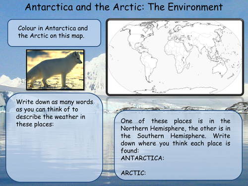
This unit consists of three double-sided worksheets which look to investigate the differences between Antarctica and the Artic, the animals to be found there and how humans are affecting these delicate environments through the impact of global warming.
A range of individual and group activities are incorporated within this booklet, including, gathering research, annotating maps, their thoughts, and ideas and completing a wordsearch.
Please like and follow us on Facebook @WillsonEducation or Pinterest @willsoned for more exciting resources, activities, and upcoming events to incorporate into your lessons.