Welcome to my shop. My aim is to provide high quality teaching, learning and assessment resources. In the case of GCSE and A Level resources I am adding examination questions to my resources as more become available. Please come in and browse. Feel free to contact me about any of the resources that you buy or if you are looking for something in particular.
Welcome to my shop. My aim is to provide high quality teaching, learning and assessment resources. In the case of GCSE and A Level resources I am adding examination questions to my resources as more become available. Please come in and browse. Feel free to contact me about any of the resources that you buy or if you are looking for something in particular.
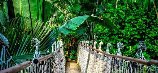
This lesson is part of a series of lessons about the rainforest ecosystem and is available as part of a bundle. This lesson starts by recalling some of the threats to the rainforest. It then introduces the idea of shifting cultivation and how it is sustainable. Next there are a series of photos of reasons for deforestation e.g. logging, mining, ranching, faming. Students are asked to consider why this is not sustainable and why it would be difficult to regrow the forest. They are then introduced to 4 schemes designed to manage the rainforest the Surui-Google partnership, REDD+, Ecotourism and sustainable agroforestry. In a group of four the students are given the information about one of the projects to simplify the project into a mind map. The groups can then give a speech presenting their findings to each other. Next they are asked to complete gap fill paragraphs explaining each project. Finally, students should work as a group to consider the relative strengths and weaknesses of the projects and evaluate which is most successful. All resources are included at the end of the PowerPoint.
The lesson starts by asking the students to consider how different parts of the reef ecosystem are interdependent. It then reminds the students of the value of reefs. Next there is a map interpretation activity showing areas of reef that are under threat followed by a you tube clip. Students are then split into groups and given a threat to coral reef in St Lucia information sheet. there are four sheets; fishing, tourism, bleaching and disease. They are asked to create a teaching resource to use to teach their peers. there is also a rate my teacher mark scheme for the students to assess each other and a note taking sheet to encourage the students to use PEE paragraphs. These can be marked using the 8 mark, mark scheme provided. There is also a threats to coral reef homework activity provided. All resources are included at the end of the PowerPoint.
This lesson starts by students interpreting temperature graphs of the quaternary showing different time scales. Next the students create a timeline from 14,000BP to the present day. They label the different climatic periods during this time and ad photos showing the different climatic features. Finally they annotate important characteristics for different climates, using a table of information to help them to do this. An answer sheet is included. To finish there is a quiz to test their knowledge of the changes. All resources are included at the end of the PowerPoint.
In this lesson students will start by recalling the threats to coral from the previous coral threats lesson. There is a speaking frame for them to explain these fully and a copy of the note taking resources. Next the students will be introduced to the Soufriere Marine Management Area and will identify features of this using a sketch map. After that the students will be read an extract about the management area, how it was set up, what the different parts are, how it is sustainable and its advantages and disadvantages. The first time they hear they extract they should draw what they hear, making sketches and using numbers and symbols to focus on important information. The second time they hear it they add written notes. Pupils should then get into small groups of 3-4 and compare notes, adding any missing details. There is an examination question for them to tackle with a mark scheme to stick in their books including ebi and www comments. Finally there is a quiz to test the students recall of the facts. All resources are included at the end of the PowerPoint.
In this lesson students are reminded of the location of reefs before being introduced to the conditions that they grow in. They are then given a table to complete about fringing reefs, barrier reefs and atolls. To help them do this there are information cards about each type of reef including photos, diagrams and maps. When they have completed this the answers are on a slide for pupils to check their work. Next they are introduced to a map showing the route of Darwin’s voyage, then the concept of eustatic sea level change and reminded about the conditions needed for coral to grow. Then they are given a diagram of all three reefs and asked to consider how a fringing reef can become a barrier reef and then an atoll (the Darwinian theory of atoll formation). Finally they could also consider that most atolls are formed on volcanic islands and the impact of coral growth on those islands. All resources are included in the PowerPoint.
Firstly, the students are introduced to the key terminology relating to water extraction. Next, students will comprehend a newspaper article to evaluate the impacts of water extraction from the aquifer surrounding Beijing. After that the students will study surface extraction on the Tigris and Euphrates and convert this information into a mind map. T consolidate students are given an examination question and asked to produce presentations on one element of the question, using the case studies. The students can then answer the question for homework or in class. All resources are included at the end of the PowerPoint.
This is the first in a series of lessons about biomes, available as a bundle. The lesson introduces students to the concept of ecosystems that occur at different scales. Students are asked to classify ecosystems of different scales. They are then introduced to abiotic and biotic factors. Biomes are located globally and students are introduced to the different types of biome. Students are then required to used graphical skills to draw and interpret graphs, showing temperature ranges and total rainfall for a range of biomes. The lesson is linked to an examination question and mark scheme and to finish there is a quiz with answers to test what the students have learned. Resources are included at the end of the PowerPoint.
These are 3 card sorts, designed to make it easy for students to learn factual information to use in their answers. These can be made into card sorts and solved. Once pupils are familiar with them they can also be given blank grids and asked to fill them in from memory.
Card sort 1- coasts case studies (Dubai, Abbotts Hall Farm, Papa Stour and Farewell Spit)
Card sort 2 - tectonics and coastal landform facts, to be used in landform explanation questions
Card sort 3 - tectonics case studies (Mt Pinatubo, Mt Ontake, Haiti, Japanese tsunami)
In this lesson pupils will learn about the pieces of evidence that can be used to show climate change and their limitations. The lesson starts by asking students to suggest evidence that can be used to show climate change. Next students use information sheets to take notes of the evidence of climate change, where they occur, how they work and any limitations. The evidence includes dendrochronology, ice cores, cave paintings, paintings and diaries and global temperature recordings. There is an answer sheet provided. For the plenary students are required to undertake examination questions relating to the evidence. All resources are included at the end of the PowerPoint.
This lesson focuses on the natural causes of climate change including sun spots, Milankovitch cycles and tectonic activity. Students should be given the information sheets and asked to make a presentation to the class explaining how their factor causes climate change. There is a note taking sheet for them to put their answers on and an answer sheet in case they missed anything. There is also a quiz on climate change since the Pleistocene at the start.
In this lesson pupils will be introduced to the population terminology needed during the whole topic. They will interpret a graph of world population growth and analyse a world population density map.
Students will hear two differing views of the same story one from an American and one from an illegal Mexican migrant. The lesson is designed to questions the pupils perceptions and to develop empathy with both characters. The stories are carefully written to allow this to happen. At the end of the lesson pupils are ask to apply what they have understood to migration to the UK and discuss who is migrating to the UK and why they are migrating.
In this lesson students will identify densely and sparsely populated areas. They will then attempt to explain why there are different population densities. There are writing and speaking frames to help them to do this. There is also a mark scheme which can be adapted to your school’s Key Stage 3 assessment policy. There are also opportunities for peer / self assessment. there are a choice of plenaries with a population terminology bingo or a prediction about the future and the impact of climate change.
This is a series of 3 lessons during which the students will research groups involved in rainforest exploitation and preservation. There are role play cards outlining the characters and a writing frame to support speech writing. There is a mark scheme which you can adapt to your schools Key Stage 3 assessment strategy. At the end there is an opinion line for pupil to consider their opinions about rainforest exploitation and preservation.
This lesson introduces the rainforest location, with a writing frame for locating the forest. It then uses a guided fantasy (story telling) to create a sense of place. There are diagrams and descriptions of the layers of the rainforest. Finally there is a plenary quiz.
The starter is a rainforest plant adaptation card sort. Students are then introduced to animal adaptations. They are then given a wide range of plant images. They have to chose one image and explain how the plant has adapted to living in the rainforest. Pupils then need to pick from a list of adaptations and design a plant, which they can then make. Once complete they need to annotate it with adaptations to living in the rainforest. Finally there is a Venn diagram comparing the rainforest to the UK.
This lesson enables students to develop an understanding of how fold mountains are formed. It starts with asking students to locate on a world maps any fold mountains before teaching them about the fold mountains, how they are formed, and categorised. It incorporates a wide range of photos and diagrams. It also includes details about faulting including nappes, recumbent folds and isoclinal folds.
The lesson is designed to be used as a cover lesson. It includes a range of tasks form analysing the site to letter writing, graph drawing and analysis. All tasks are designed to be completed on worksheets, answers to the work sheets are included towards the end. A lesson plan is included.
This lesson starts with coastal terminology bingo. It then combines diagrams and photos to build up descriptions and explanations of the formation of spits, bars and tombolos. OS Maps, photos and satellite images of the different landforms are included. there is a word bank and a sequence chart to support he students in writing their explanations. There are also additional details about other climatic factors that may have formed the bars and tombolos in Dorset and Devon. At the end of the lesson is an exemplar 16 mark examination question and a plan for how to attempt it.
This homework task requires students to assess the risk of flooding to their house, using the Environment Agency GIS flood maps. It then asks them to compare this to a house in Carlisle. In addition there are optional extension tasks.