Providing quality tested Geography resources at an affordable price. Take the stress out of your teaching and enjoy what many teachers joined the profession for, working with young people. Please follow & review to help me grow my store!
Providing quality tested Geography resources at an affordable price. Take the stress out of your teaching and enjoy what many teachers joined the profession for, working with young people. Please follow & review to help me grow my store!
< Description coming soon>
Check out my other topic bundles!
Weather & Climate Topic Bundle
Africa & The Development Gap Topic Bundle
Investigating China Topic Bundle
Globalisation Topic Bundle
Tectonic Hazards Topic Bundle
India & The Plastic Problem Topic Bundle
Earth’s History Topic Bundle
Geographical Skills Topic Bundle
Energy & Climate Change Topic Bundle -(Coming soon)
This 12 week scheme investigates China. China has a rich and unique heritage, spanning back thousands of years. Its huge size produces diverse landscapes and unique physical Geography, found nowhere else in the world. These contrasting landscapes are mirrored by huge inequalities across its human landscapes. Stark population differences and large discrepancies in standards of living across the country provide interest, given how China portrays itself at the world stage. The decisive but often controversial decisions made by the Chinese government have helped China’s economy grow to become one of the largest in the world. This unit investigates this growing superpower, evaluating the impacts of physical Geography and government policy on development across the nation.
Check out my other topic bundles!
Weather & Climate Topic Bundle
Africa & The Development Gap Topic Bundle
Globalisation Topic Bundle
World Tourism Topic Bundle
Tectonic Hazards Topic Bundle
India & The Plastic Problem Topic Bundle
Earth’s History Topic Bundle
Geographical Skills Topic Bundle
Energy & Climate Change Topic Bundle -(Coming soon)
If you like my work, please follow me for more resources and leave a review!
This 2 hour KS3 lesson investigates what an earthquake is, as well as how they are measured and recorded. A map task used for pupils to reflect on where earthquakes occur. A flow diagram task is included on the causes of earthquakes as well as interactive slides of how seismometers work. A student led role play task is used to teach the Richter scale and card sort task for the Mercalli scale. Additional homework task included.
Bundle and save! This lesson is part of a larger bundle:-
Tectonic Hazards Topic Bundle
Check out some of my other products relating to Tectonic Hazards:-
What factors effect the risk from natural hazards?
What are the layers of the Earth?
What are tectonic plates?
Why are earthquakes and volcanoes found at plate boundaries?
What are earthquakes?
Are tsunamis the deadliest natural hazard?
Why live in tectonically active regions?
How can hazard risk be mitigated?
If you like my work, please follow me for more resources and leave a review!
This 1 hour KS3 lesson investigates the influence of India’s physical Geography on the distribution of its major cities. Pupils produce a choropleth map to show how elevation changes across the country. Students describe this map, developing analytical skills and consider why Indian cities may contribute significantly to ocean plastic.
Bundle and save! This lesson is part of a larger bundle:-
India & The Plastic Problem
Check out some of my other products relating to India & The Plastic Problem:-
Why is plastic hazardous?
Where is India and what is it like?
How does India’s physical Geography influence the location of its major cities?
Why does India have a monsoon climate?
How do ocean gyres move plastic pollution?
How developed is India?
Why does India have so many squatter settlements?
What are the impacts of marine plastic waste?
How can plastic waste be reduced?
If you like my work, please follow me for more resources and leave a review!
This 1 hour KS3 lesson investigates the useful but problematic properties of plastic. Pupils consider why plastic is so versatile and reflect on why this makes plastic so hazardous. Students create a timeline to show how long it takes various pieces of house hold waste to break down, and reflect on whether this should have more of an influence on our choice of materials.
Bundle and save! This lesson is part of a larger bundle:-
India & The Plastic Problem
Check out some of my other products relating to India & The Plastic Problem:-
Why is plastic hazardous?
Where is India and what is it like?
How does India’s physical Geography influence the location of its major cities?
Why does India have a monsoon climate?
How do ocean gyres move plastic pollution?
How developed is India?
Why does India have so many squatter settlements?
What are the impacts of marine plastic waste?
How can plastic waste be reduced?
In this 2 hour KS3 resource pupils contrast the quality of life in Ghana with that of the UK. Pupils are first taught how to describe the location of Ghana at various scales. Source analysis is used to stimulate discussion regarding living conditions within Ghana. Pupils read an interview of a girl living in Ghana and consider how her quality of life will be affected by her living conditions. The text is annotated with prompt questions to stimulate discussion and allow pupils to complete the worksheet activity. The learning is later assessed through a extended independent writing task. A writing frame is provided to guide pupils and improve structure.
**Bundle and save! This lesson is part of a larger bundle:- **
Development topic bundle
Check out some of my other products relating to weather and climate:-
What is development?
How can we measure development?
What are the causes of global inequality?
What is Africa like?
What are Africa’s climate zones?
How do squatter settlements affect peoples quality of life?
How can fair trade help to reduce the development gap?
In this** 2 hour KS3 lesson** pupils describe how both temperature and rainfall vary across the UK. Students investigate how latitude, altitude, ocean currents and winds influence climatic conditions. Class worksheets are included and a source based formative assessment activity.
**Bundle and save! This lesson is part of a larger bundle:- **
Weather topic bundle
Check out some of my other products relating to weather and climate:-
What is the difference between weather and climate?
What is the water cycle?
How can symbols be used to show weather patterns?
How can we describe weather patterns using weather symbols?
Is all rainfall produced in the same way?
Why do floods occur and what are the effects?
In this 1-2 hour KS3 lesson pupils undertake a role play exercise in which they report on UK weather. Template weather scripts, base map and weather symbols are all included as well as a self and peer assessment sheet.
**Bundle and save! This lesson is part of a larger bundle:- **
Weather topic bundle
Check out some of my other products relating to weather and climate:-
What is the difference between weather and climate?
What is the water cycle?
How can we describe weather patterns using weather symbols?
Is all rainfall produced in the same way?
Why does the UK experience the weather it does?
Why do floods occur and what are the effects?
This 1 hour KS3 resource lesson investigates the main differences between weather and climate. Pupils learn how aspects of the weather change over a short term basis and practice locating global climate zones. Understanding is tested through a tour operator task at the end of the lesson.
**Bundle and save! This lesson is part of a larger bundle:- **
Weather topic bundle
Check out some of my other products relating to weather and climate:-
What is the water cycle?
How can symbols be used to show weather patterns?
How can we describe weather patterns using weather symbols?
Is all rainfall produced in the same way?
Why does the UK experience the weather it does?
Why do floods occur and what are the effects?
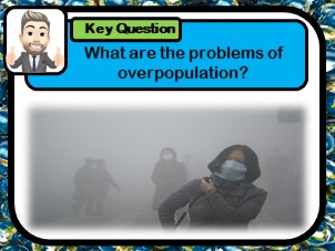
This 2 hour KS3 lesson teaches pupils about the detrimental impacts of rapid urbanisation. Pupils start the lesson describing the location of Chongqing, Chinas most polluted city. A video and question worksheet is used to set the scene. Pupils then learn how to elaborate statements through a mix and match exercise. A card sort tasks is used to evaluate the causes and effects and of overpopulation, as well as potential solutions.
Check out some of my other products relating to China:-
Where is China?
What physical and human Geography exists across China?
How is the population distributed across China?
What is rural to urban migration and why does it occur?
How developed is China?
Was China’s one child policy an example of successful population control?
If you like my work, please follow me for more resources and leave a review!
This 1 hour KS3 lesson teaches students the difference between a product and a service. Pupils use an atlas and world map to locate where personal items were manufactured. This introductory lesson illustrates the concepts of global trade and interdependence.
Check out some of my other products relating to Globalisation:-
What are producers and consumers?
How has employment structure changed in the UK?
What is globalisation?
What factors have caused globalisation?
Why is Apple such a successful global brand?
How do conflict minerals affect people living in Africa?
Does slavery still exist? (Investigating Apple’s iPhone factories)
If you like my work, please follow me for more resources and leave a review!
This 1 hour KS3 lesson teaches pupils about the differences between producers and consumers. This introductory lesson investigates the range of scales at which businesses operate. Pupils develop Geographical skills, reflecting on global fuel consumption through cartogram analyse.
Check out some of my other products relating to Globalisation:-
What are products and services?
How has employment structure changed in the UK?
What is globalisation?
What factors have caused globalisation?
Why is Apple such a successful global brand?
How do conflict minerals affect people living in Africa?
Does slavery still exist? (Investigating Apple’s iPhone factories)
If you like my work, please follow me for more resources and leave a review!
This 1 hour KS3 lesson investigates how and why companies are able to become global brands. Pupils develop their awareness of the characteristics of transnational co-operations, using Apple as a case study. Pupils engage in a duel-coding activity, learning the benefits of producing and selling goods in lots of countries around the world.
Check out some of my other products relating to Globalisation:-
What are products and services?
What are producers and consumers?
How has employment structure changed in the UK?
What is globalisation?
What factors have caused globalisation?
How do conflict minerals affect people living in Africa?
Does slavery still exist? (Investigating Apple’s iPhone factories)
If you like my work, please follow me for more resources and leave a review!
This 2 hour introductory KS3 lesson to tectonics looks at the structure of the Earth, investigating the crust, mantle and core. The lesson includes a music video to help pupils remember the Earth’s layers, as well as a card-sort task and several learning games.
Bundle and save! This lesson is part of a larger bundle:-
Tectonic Hazards Topic Bundle
Check out some of my other products relating to Tectonic Hazards:-
What factors effect the risk from natural hazards?
What are the layers of the Earth?
What are tectonic plates?
Why are earthquakes and volcanoes found at plate boundaries?
What are earthquakes?
Are tsunamis the deadliest natural hazard?
Why live in tectonically active regions?
How can hazard risk be mitigated?
If you like my work, please follow me for more resources and leave a review!
This 2-3 hour KS3 lesson introduces the two crust types as well as the four plate boundaries. Pupils learn through a game, as well as a dance, the names of and movement at the different boundaries. A wide range of differentiated worksheets for higher and lower abilities are included on each boundary as well as catchphrase and taboo games as plenary tasks.
Bundle and save! This lesson is part of a larger bundle:-
Tectonic Hazards Topic Bundle
Check out some of my other products relating to Tectonic Hazards:-
What factors effect the risk from natural hazards?
What are the layers of the Earth?
What are tectonic plates?
Why are earthquakes and volcanoes found at plate boundaries?
What are earthquakes?
Are tsunamis the deadliest natural hazard?
Why live in tectonically active regions?
How can hazard risk be mitigated?
If you like my work, please follow me for more resources and leave a review!
This lesson looks at the factors affecting risk from natural hazards. The lesson uses image analysis to invoke independent thinking and later looks at how geographical position influences the impacts of various hazards. There is a challenging group question task, where pupils reflect on how damages may be reduced, as well as an exam question and mark scheme to be used as a homework task. This lesson investigates what hazards are and how they impact on human settlements. There independent thinking tasks included as well as example exam questions.
If you like my work, please follow me for more resources and leave a review!
This one hour lesson teaches pupils about the natural beauty of the Lake District national park (England). Students consider the importance of national parks and locate the Lake District on a template map. Students use both video and source images to produce a piece of descriptive writing outlining the characteristics that attract people to this national park. Sentence stems provided to guide weaker learners.
In this 2 hour KS3 resource pupils investigate the Sahara desert. The lesson teaches pupils how to describe the distribution of desert environments around the world. The students are required to use climate data to produce a climate graph, with subsequent questions testing interpretation skills. A diamond 9 activity is used to evaluate the hostile conditions of desert environments. Information sheets are also provided allowing pupils to research the Sahara desert independently in groups.
This 1-2 hour KS3 resource investigates the effectiveness of fair trade at reducing the development gap. Pupils undertake a role play exercise, in which they take on the roles of different employees within the banana trade chain. Participants have to argue why they feel they deserve a particular proportion of the bananas cost. Students then watch a video and consider how fair trade can help improve the quality of life for people growing bananas in Africa?