I am a Geography specialist who has also been teaching GCSE history for the past few years. I have uploaded some lessons for History and Geography. I hope people find them useful.
I am a Geography specialist who has also been teaching GCSE history for the past few years. I have uploaded some lessons for History and Geography. I hope people find them useful.
AQA GCSE Geography lesson for the new specification Unit 1C: In this lesson we look at erosion, transportation and deposition.
The starter is “which row is the odd one out”. The pupils need to work out which row has an incorrect term in. Just gets them thinking.
We then look at erosion and when rivers are eroding more effectively. The pupils learn about vertical and lateral erosion and will be making some diagrams in there exercise books. They then receive a worksheet where the processes of erosion and transportation are illustrated, the pupils use an information slide (or sheet if you prefer) and label the processes on and colour code the area of the diagram where that process is displayed. We then look at how these processes vary as you progress down the long profile of a river. The pupils get another worksheet where they read the labels and draw an appropriate diagram in each box to create an illustrated log profile. We finish with a summarising pyramid plenary.
In a nutshell lesson includes:
Odd one out starter.
Vertical and lateral erosion diagram activity
Worksheet on processes of erosion
Worksheet activity on processes of erosion along the course of a river
Summarising pyramid
Hope this saves you some valuable planning time.
https://www.tes.com/teaching-resources/shop/markthegeographer
This bundle includes all lessons on Lagos for the AQA specification Unit 2 section A.
Lessons include a variety of activities, video clips, exam-style questions and worksheets ready to print or copy.
the sequence of lessons is :
Introducing Lagos
Growing Lagos
Social challenges in Lagos
Economic challenges in Lagos
Improving Lagos’ environment
Managing Squatter Settlements in Lagos
Urban planning in Lagos
Hope this saves you some valuable planning time.
https://www.tes.com/teaching-resources/shop/markthegeographer
AQA GCSE Geography lesson for the new specification Unit 2A: In this lesson we look at where people in the UK live and the reasons for our population distribution.
The starter is based on the population total for the UK and the pupils have some questions to think about. I usually do this as a discussion. There is also a can you name 15 cities starter which works well for high ability groups.
We then look at cities in the UK. the pupils have a map and need to find the location of some of the major cities in the UK, we then briefly talk about their distribution. Next the pupils consider the human and physical factors that affect population distribution before putting this knowledge to work on a worksheet with several tasks and questions.
We finish with GCSE-style question on human and physical factors that affect population distribution.
In a nutshell lesson includes:
Two starters on population and cities.
Map task on the major cities of the UK
Worksheet on the population distribution in the UK
Video clips where appropriate
GCSE-style question with guidance on how to respond.
Hope this saves you some valuable planning time.
https://www.tes.com/teaching-resources/shop/markthegeographer
AQA GCSE Geography lesson for the latest specification Unit 1B: In this lesson we look at the types of erosional landforms you find in glaciated landscapes.
The starter is just a quick coast-themed retrieval practice quiz which has been left blank so you can add your own questions.
We start by looking at the erosive power of glaciers and how corries form in highland areas. The pupils create a sequential diagram to show how a corrie forms from small nivation hollows. We then look at aretes and pyramidal peaks with examples of each and then look at how erosion has created a variety of further highland erosional features when the pupils annotate a diagram of a highland glaciated area. We finish with a 6 mark GCSE-style exam question with guidance on how to answer it. The lesson also uses some video clips to help the pupils visualise these features.
Hope this saves you some valuable planning time.
https://www.tes.com/teaching-resources/shop/markthegeographer
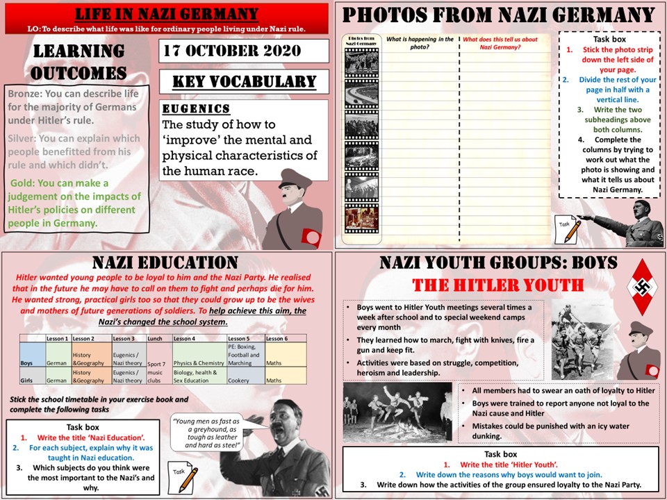
Key Stage 3 lesson for a scheme of work on The Rise of The Dictators. In this lesson we look at what life was like for people living in Nazi Germany. We start with an activity called ‘Photos from Nazi Germany’. The pupils try to work out what is going on in the photos and what this tells us about life in Germany at this time. We then look at life for different types of adults, we use an evidence sheet and the pupils make notes about how those people perhaps benefited, or suffered under Nazi rule. We then look at young people. We start by analyzing a school day fro the German school pupil and why the Nazi’s wanted certain subjects to be taught. We then look at the Hitler Youth and the league of German Maidens and why young people were drawn to these groups and what purpose they served the Nazi’s
I hope this proves useful and saves you some time.
https://www.tes.com/teaching-resources/shop/markthegeographer
AQA GCSE Geography lesson for the latest specification Unit 1B: In this lesson we look at transportation and depositional landforms such as moraines, drumlins and erratics.
The starter is glaciation-themed retrieval quiz.
We then look at the idea of the glacial conveyor belt, what glacial till is and what the difference between sorted and unsorted material is and why they form in different environments. The pupils create diagrams of both. We then consider moraines and the different types of moraines. The pupils have a diagram to annotate and label. We then consider drumlins, the pupils again create diagrams and learn why they show direction of movement and collective called ‘basket of eggs’ topography. We then briefly look at erratics and how they can also show the history of glacier movement. We finish with a 4 mark GCSE-style exam question with guidance on how to answer it.
Hope this saves you some valuable planning time.
https://www.tes.com/teaching-resources/shop/markthegeographer
AQA GCSE Geography lesson for the new specification Unit 2A: For this section we use London as our case study. In this lesson we introduce London, it’s location and site factors and its population.
We start with a simple quiz about London to test the pupils general knowledge of the capital.
We then look at the location of London and the pupils describe London’s location based on the C.L.O.C.K formula. But you could use any method. We then have a look at the history of London before the pupils undertake an ‘art attack’ activity where they are creating an annotated sketch map of the location of London and it’s settlement site factors. We then look at London’s population, looking at general facts, population structure and ethnicity.
We finish with a simple GCSE-style question plenary.
In a nutshell lesson includes:
Quiz on general knowledge of London.
Locating London activity
‘Art attack’ activity with guidance on producing an annotated sketch map
Video clips where appropriate
Population pyramid activity
Graph interpretation task on ethnicity in London
GCSE-style question with guidance on how to respond
Hope this saves you some valuable planning time.
https://www.tes.com/teaching-resources/shop/markthegeographer
AQA GCSE Geography lesson for the new specification Unit 2A: In this lesson we look at air quality and waste management issues in London.
There is a photo interpretation starter around landfill in London, e usually discuss how landfill and disposal is not a sustainable method of waste disposal.
We then look at air quality in London, we consider the causes of poor air quality in the city and the pupils explain the causes using the hexagons. We then consider which is the most likely cause of air pollution in London. We then use nitrogen dioxide as a proxy for air pollution and the pupils create a map to show where the concentrations are high. We discuss why this might be. We briefly look at London’s cycle super highways as a potential solution to air pollution.
Moving on to waste management the pupils create a pie chart to show how London disposes of its waste, we use the pie chart and look at the city of London’s hierarchy for dealing with waste and consider how successful they have been at meeting their targets.
Once we have completed the diagram we tackle a 6-mark question on waste disposal. There is guidance should the pupils need it.
In a nutshell lesson includes:
Photo Interpretation Starter
Causes of air pollution hexagon task.
Mapping activity using nitrogen dioxide as a proxy for air pollution
Video clips where appropriate
Pie chart activity
GCSE-style question with guidance or live writing exercise.
Hope this saves you some valuable planning time.
https://www.tes.com/teaching-resources/shop/markthegeographer
AQA GCSE Geography lesson for the new specification Unit 2A: In this lesson we look at the increasing number of the global population living in urban areas.
We start with a quick quiz on global populations and a video to put global population increase into context for the pupils. We then look at how urbanisation varies around the world by plotting data on a graph. The pupils then describe the trends they have found.
We then look at a map of the urban populations around the world and the pupils can tackle several different questions depending on ability. We then discuss how these patterns might be explained. We then answer a GCSE-style question looking at the percentage of people living in urban areas on different continents using a bar chart. The pupils have guidance on how to answer the question if needed. We finish with a plenary quiz where the pupils have to find the countries with an urban population of over 50%.
In a nutshell lesson includes:
Quiz starter
Video clip
Graph plotting exercise with questions
Map interpretation task
GCSE-style question using graph with guidance
Plenary quiz.
Hope this saves you some valuable planning time.
https://www.tes.com/teaching-resources/shop/markthegeographer
Key Stage 3 lesson on comparing and contrasting Richard I with Saladin. The lesson would take about two periods to cover fully, but can easily be shortened. We start by thinking about what makes an effective leader during the medieval period.
we then introduce the two leaders and the pupils will read the story of each leader before creating a character card that assesses the leaders strengths and weaknesses. We then go on to look at how the two men are similar and different by creating a Venn diagram. Finally there is an extended writing task where the pupils explain their choice of leader through evaluating their actions. Included in the lesson is:
Starter activity
Character card templates and information sheets on the leaders
Venn diagram task
Extended writing task with writing frame and support.
Plenary.
Hope this helps.
https://www.tes.com/teaching-resources/shop/markthegeographer
AQA GCSE Geography Lesson for the Nigeria: A Newly Emerging Economy unit. The lesson is at lest one hour long, but is easily extended into two lessons. The lesson begins with a photo interpretation starter to introduce the pupils to some of the poverty in Nigeria. We then look at two families in Nigeria, the pupils investigate their living conditions and access to safe water, sanitation and electricity before deciding if the family would benefit from aid and if they represent the majority of Nigerian families. We the look at the benefits of International Aid and the reaons why aid may not be used effectively. We use a GCSE-style question to investigate the latter. Included in the lesson is:
Photo interpretation starter
Families task: comparing living standards (how will aid benefit them?)
Hexagon factor task explaining how aid benefits Nigeria.
GCSE style question on how aid might not be used effectively.
Hope this helps.
https://www.tes.com/teaching-resources/shop/markthegeographer
Power & the People lesson on the Chartists. In this lesson we introduce the Chartists and Chartism. We then look at what the demands of the Chartists were and how they believed they would make for a fairer electoral system. We then examine the methods of the Chartists and how they were successful at spreading their message. We then look at the failure of Chartism and examine the reasons for this before finishing with how significant the movement was in the end. Included in the lesson is:-
Question starter around Secret Ballots
Activity on the Chartists Six Point Demands
Video Clip
Activity examining the methods of the Chartists
Writing activity on the failure of Chartism
Question on the significance of Chartism.
Hope this helps
https://www.tes.com/teaching-resources/shop/markthegeographer
AQA GCSE Geography lesson for the new specification Unit 1A: In this first lesson in the section we look at what the evidence is for climate change.
We start with a picture interpretation around frost fairs on the River Thames and how this might be evidence for climate change.
We then look at the graphs that scientists have composed that show how our climate has fluctuated over the years. The pupils will have a large A3 activity sheet to fill in as the lesson progresses. The second section looks at ice cores and how they have helped the scientists formulate records of past climates. We then look at the impacts of global climate change and how they might also be evidence for climate change too. The pupils will write down their own ideas then elaborate with the help of the slides and some video clips.
We finish with GCSE-style question with some suggested content if they need help.
In a nutshell lesson includes:
Picture interpretation starter
A3 activity sheet on the evidence for climate change
Video clips where appropriate
GCSE-style question with guidance on suggested content.
Hope this saves you some valuable planning time.
https://www.tes.com/teaching-resources/shop/markthegeographer
AQA GCSE Geography lesson for the new specification Unit 2A: In this lesson we look at the what urban sustainability is and how it can be achieved.
The lesson has two retrieval practice starter options for you to populate. We then introduce the concept of urban sustainability. The pupils then complete a variety of tasks as we look at water conservation (with Cape Town as an example of water stress). Sustainable Drainage Systems (SuDS). Methods of energy conservation, waste management and recycling, and creating green spaces. We finish with a GCSE-style practice question with some guidance and structure provided for the students.
Hope this saves you some valuable planning time.
https://www.tes.com/teaching-resources/shop/markthegeographer
AQA GCSE Geography lesson as part of the Nigeria: A Newly Emerging Economy unit. The lesson is roughly one hour long but can be shortened or extended. In this lesson we introduce the concept of a TNC. We then do a quick activity on the incentives for TNC’s to locate their operations in different countries. The pupils then complete a sorting exercise on the problems and benefits of TNC’s in general before we look at Shell’s operations in the Niger Delta. The pupils create a visual chart to show the overall benefits and costs, but also the extent to which those factors are benefits or costs. We then go on to answer a 6 mark question with a structure strip for support. Included is:
Starter on TNC’s in Nigeria
Exercise on incentives for TNC’s in countries
Sorting activity on costs and benefits
Costs and benefits chart on Shell Oil
GCSE style question with structure strip
Hope this helps.
https://www.tes.com/teaching-resources/shop/markthegeographer
Key Stage 3 lesson on the crusades. The lesson is at least an hour long and can easily be two lessons.
We start with retrieval practice starter. We then go on to introduce the concept of a crusade. We then examine Pope Urban’s famous sermon looking for threats to christians and potential rewards. We then introduce King Richard I before a classification task on the reasons why people went on crusade. The pupils classify the reasons in either money and power or religious reasons. The pupils then rank the reasons to work out what the main appeal of the crusades were. We then finish with a writing task where the pupils create a diary entry having been invited to join Richard’s crusade. Included is:
Retrieval practice starter
Source analysis task on Urban’s sermon of 1095
Classification task "For God or Gold"
Extended writing task using a diary entry narrative.
Post-it note plenary.
Hope this helps.
https://www.tes.com/teaching-resources/shop/markthegeographer
AQA GCSE Geography lesson for the Nigeria: A Newly Developing Economy section. The lesson is roughly one hour long but can be extended or shortened. We start by considering what quality of life means with a starter task. We then complete an activity which looks at how an improving economy can improve quality of life. We then move onto a skills task which involves the pupils plotting out indicator data for Nigeria and determining what this shows about quality of life in the country over the last 30 years. The pupils complete and extract task on whether all Nigerians have experienced better quality of life then complete a diagram to show what barriers to improving this are still to be overcome. We then conclude with a 6 mark GCSE style question with some guidance for the pupils if they need it. Included is:
starter activity on quality of life
Annotation task on how improving economy improves quality of life
Graphical skills task on indicator data and interpretation questions
Extract highlighting and interpretation task.
Explanation task on barriers to improving quality of life
6-mark question with guidance and timer
Hope this helps.
https://www.tes.com/teaching-resources/shop/markthegeographer
AQA GCSE Geography lesson for Unit 2C: Resource Management. The lesson realistically takes over one hour, most likely two lessons.
We start we a quiz on what percentage we use of our water for various domestic tasks. We then complete a data presentation activity where the pupils create a graph on our national demands on water and the pupils then complete some questions. The next task involves the pupils creating two shaded maps of population density and rainfall to work out where the areas of water stress are in the UK. We then look at water stress and highlight an extract to explore the benefits and drawbacks. The pupils then create a diagram on the work of the Environment Agency in managing water supplies The pupils look for solutions to improving water quality and challenges to improving water quality. We finally tackle a GCSE-style 6 mark question on water transfer.
At a glance lesson includes:
Starter quiz on domestic water use
Data presentation activity on national water use
Map shading activity to work out areas of water stress
Extract highlighting activity
Environment Agency diagram activity
6 mark practice question with guidance and timer.
Hope this helps.
https://www.tes.com/teaching-resources/shop/markthegeographer
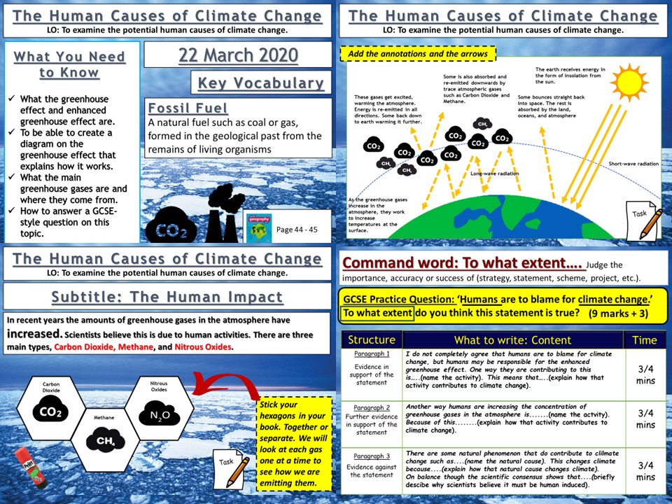
AQA GCSE Geography lesson for the new specification Unit 1A: In this third lesson in the section we look at the possible human causes of climate change.
We start with a simple retrieval practice grid based on previous learning.
We then look at what the scientist think and how a consensus has grown about the impact of anthropogenic influences on the climate and we watch a clip that summarises this. We then create a diagram in our books and the students are guided step by step through the greenhouse effect, creating the diagram as they go. The pupils then watch video clips on the three main greenhouse gases, carbon dioxide, methane and nitrous oxides. The pupils make notes around their hexagons using the video clips to help. We finish by looking at the ‘enhanced greenhouse effect’ and a 9-mark gcse-style question with guidance on how to answer for the pupils.
We finish the lesson with a GCSE-style question post-it plenary.
In a nutshell lesson includes:
Retrieval practice starter
Greenhouse effect diagram.
Hexagon task on the main greenhouse gases
Video clips where appropriate
GCSE-style question.
Hope this saves you some valuable planning time.
https://www.tes.com/teaching-resources/shop/markthegeographer
Key Stage 3 History lesson which is at least two hour-long lessons. We start with a photo interpretation starter “Why is Simon’s Head in the Wall?”. The pupils try to deduce what happened to Simon of Sudbury. We then go onto to watch a video clip on the Peasants Revolt. The pupils have a crib sheet to fill in as the video plays. We then look at the events of the peasants revolt where the pupils complete an activity that involves summarising events and drawing symbols and diagrams. using the information the pupils have gained they then design a movie poster for a film about the Peasants Revolt where the pupils can show their knowledge and be creative!
In a nutshell the lesson includes.
Photo interpretation starter
Video clip with crib sheet
Events of the Peasants Revolt activity
Design a movie poster task
Plenary.
Hope this saves you some valuable planning time.
https://www.tes.com/teaching-resources/shop/markthegeographer