I am a Geography specialist who has also been teaching GCSE history for the past few years. I have uploaded some lessons for History and Geography. I hope people find them useful.
I am a Geography specialist who has also been teaching GCSE history for the past few years. I have uploaded some lessons for History and Geography. I hope people find them useful.
Key Stage 3 lesson for a scheme of work on The Rise of The Dictators. In this lesson we look at the early problems facing Germany after WWI to set the scene for the rise of the Nazi Party. We then look at the Weimar Golden Years and what Germany was like in the 1920’s. We then track Hitlers early life and look for ‘alarm bells’. These are events in his life that shaped his ideologies or betrayed his wish to be a ruthless dictator. We then look at how the Wall Street Crash played into the Nazi’s hand and the pupils complete a text analysis to learn how Hitler became Chancellor in 1933 and then Fuhrer in 1934.
I hope this proves useful and saves you some time.
https://www.tes.com/teaching-resources/shop/markthegeographer
AQA GCSE Geography lesson for the new specification Unit 1C: In this lesson we look at how waves are formed and different types of waves.
We start with a differentiated photo starter where the pupils can create questions for themselves or the teacher to answer on coastal erosion.
We then introduce waves by watching big wave surfers at Nazare in Portugal. This is where the largest onshore waves in the world are found. The pupils then make an annotated step by step guide to how ripples turn into large waves. We then look at what happens when the waves arrive on-shore. The pupils make an annotated diagram. We then look at constructive and destructive waves. The pupils make pop-up versions of both wave types to go into their books with annotations.
We finish we a simple 4-mark question on the differences between constructive and destructive waves with some guidance.
In a nutshell lesson includes:
Photo interpretation question creator starter
Annotated step by step diagrams of wave formation
Diagram of the process of waves breaking
Pop-up destructive and constructive waves.
Video clips where appropriate
GCSE-style question with guidance
Hope this saves you some valuable planning time.
https://www.tes.com/teaching-resources/shop/markthegeographer
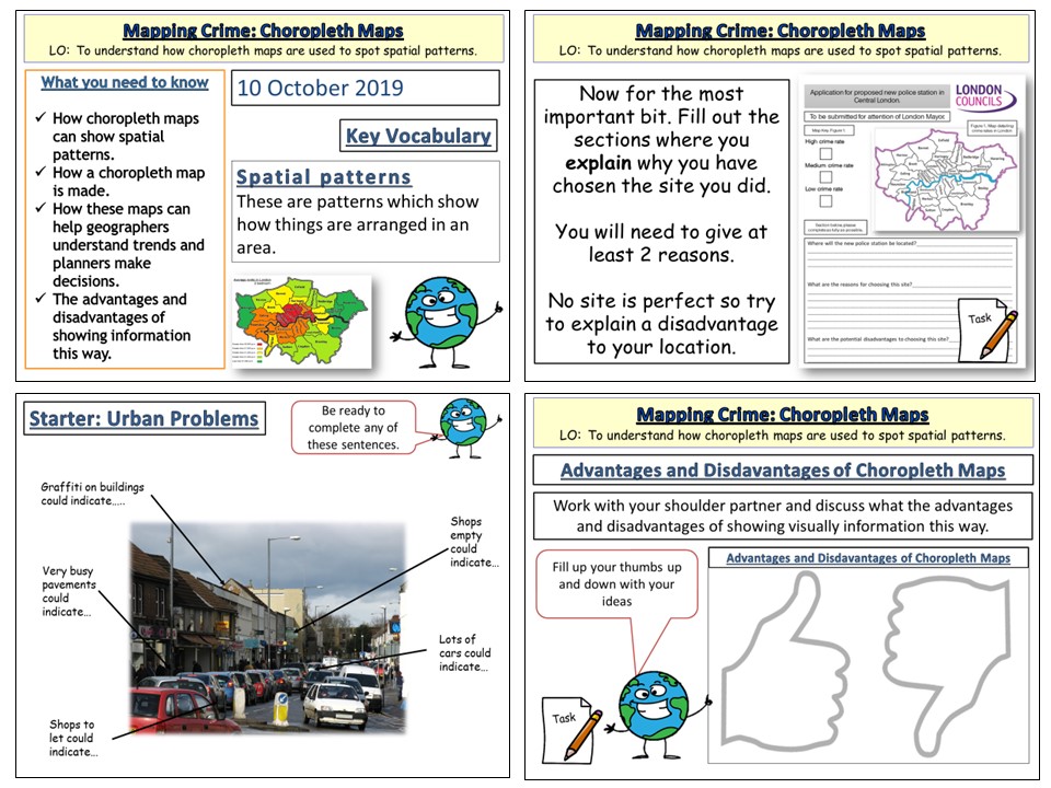
This is a 1 hour geographical skills lession aimed at Key Stage 3. The lesson includes:-
Starter on urban problems.
Introduction to Choropleth maps.
Pupils then create a map of crime in London.
Pupils then decide and justify where a new police station will be located.
Advantages and Disadvantages of Choropleth Maps.
The lesson would work well as part of a Geography & Crime unit of work or a stand alone lesson on choropleth maps.
https://www.tes.com/teaching-resources/shop/markthegeographer
GCSE Geography lesson for AQA specification. Unit 2C Water Management.
in this lesson we start by looking at an advert aimed at conserving water in the household. The pupils need to work out what the adverts message is. The second clip shows the adverts true purpose. We then look at what sustainable supplies mean before completing a factor hexagon task on water conservation. We then go on to domestic water supplies and how we can save water at home. the pupils sketch a house in 2 mins, before being given the success criteria afterwards as an example of why checking mark schemes for question types is a good idea. We then annotate around the outside ways we can conserve water at home. The pupils then complete an activity involving an extract which they use to answer questions. We finish with a GCSE-style question with some guidance on how to answer it.
In a nutshell the lesson includes:
Video advert starter
Factor hexagon task on water conservation
Domestic water use task
Extract task with questions on methods of water conservation
GCSE-style question with guidance if the pupils need this.
hope this helps save you some valuable planning time.
https://www.tes.com/teaching-resources/shop/markthegeographer
AQA GCSE Geography lesson on the Environmental Characteristics of Hot Deserts. This is the second lesson on Hot Deserts for the AQA specification. The lesson includes:
Camel starter activity
Worksheet on plant and animal adaptations
Video clips
4-mark exam question
Plenary memory activity.
The pupils will work there way through these tasks and gain an understanding of plant and animal adaptations.
Hope this helps.
https://www.tes.com/teaching-resources/shop/markthegeographer
AQA GCSE Geography lesson for Unit 1a. in this lesson we start with a photo starter of a pyroclastic flow where the pupils can design their own GCSE style question then answer. We then move on to look at interpreting photographs of natural hazards which is something we do more of later in the unit. We practice on the landslides in Burundi in 2015. We then look at when a natural event becomes a natural hazard. We progress to categorising various hazards to introduce the categories of hazards. We watch a short video clip on human interaction with natural hazards before the students complete a mind map using hexagons of the factors that increase hazard risk. We finish with a practice question with guidance should the students need it.
In a nutshell, the lesson includes:
Create a question starter
Photo interpretation task
Hazard categorising shaded grid task
Video clip
Factors mind map task
GCSE practice question with writing frame.
Hope this saves you some valuable planning time.
https://www.tes.com/teaching-resources/shop/markthegeographer
AQA GCSE Geography lesson for the new specification Unit 1C: In this lesson we look at coastal landforms along the Swanage coastline.
The starter is called “perfect paragraph?” The pupils will see a response to a GCSE-style question and need to spot the errors in the paragraph, we then discuss if anything needs adding to the answer.
We introduce Swanage to the pupils and its location. The pupils will be working on an A3 sheet of paper that will become a revision resource for them in the future. We start by locating Swanage and the pupils describe its location using geographical language. We the look at the discordant and concordant sections of the coastline and the pupils create an annotated map showing the locations of the landforms we will study as well as an explanation of how the geology affects the coastline. We then look at Old Harry Rocks. The pupils will do a field sketch from photograph which they then label to show all the features on the landform. We then look at Lulworth Cove and how it has formed on a concordant coast. The pupils create a 3 stage diagram to show how this formed., they annotate this too/
We finish with a post-it plenary based on a short question regarding the content of the lesson.
In a nutshell lesson includes:
Perfect paragraph? Starter.
A3 poster worksheet with a variety of activities on the landforms around Swanage.
Video clip.
Post-it plenary.
Hope this saves you some valuable planning time.
https://www.tes.com/teaching-resources/shop/markthegeographer
AQA GCSE Geography lesson from the Nigeria: A Newly Emerging Economy Unit.
The Lesson needs the Oxford AQA GCSE Geography textbook
The lesson is roughy one hour long, but can be extended or shortened, The lessons starts with an annotation exercise on an image of slums in Lagos. The pupils explore the environmental problems in the image and potential causes and solutions. We then take a short look at a video clip of an illegal oil extraction operation in the Niger Delta and asked how rapid developemnt may have led to this. The pupils then move onto an A3 information gathering task usingthe Oxford textbook. The sheet is differentiated with a variety of tasks. We then finish the lesson by attempting to answer a 6-mark question on environmental issues with guidance and structure if the pupils need it. Included is:
Photo annotation starter
Two relevant video clips
A3 information organiser task
GCSE question with structure and guidance.
Hope this helps.
https://www.tes.com/teaching-resources/shop/markthegeographer
Key Stage 3 lesson for a scheme of work on The Rise of The Dictators. In this lesson we look at Stalin’s leadership of the Soviet Union and his actions. We start with a quick retrieval practice quiz. We then introduce Stalin via a video clip and the pupils complete sentences as they watch the clip. We then look at Stalin’s actions as leader and the pupils decide if they are good ideas or bad ideas using a visual indicator scale and explanation. We then look at how different types of people within the Soviet union would react to Stalin’s actions as leader. We look at a source and the pupils answer a GCSE-style 4-mark question.
I hope this proves useful and saves you some time.
https://www.tes.com/teaching-resources/shop/markthegeographer
AQA GCSE Geography lesson for the new specification Unit 1C: In this lesson we look at the processes of erosion and transportation (Note we don’t do longshore drift until the next lesson, too much for one lesson!)
We start with a retrieval practice grid from the previous lesson (good for spaced practice).
We then introduce the concept of erosion, we watch a short video clip of he problems at Dawlish several years ago to get the pupils thinking about why erosion is important. We then look at erosion first, the pupils have a worksheet which shows the processes. They need to describe the process, locate the process on the map with an arrow and as a bonus they get to colour the diagram in (They still love doing this in year 11). We briefly look at the four processes of transportation and they do the same thing on the diagram.
Next we explore what factors might affect the rate of these processes occurring. I get the pupils to do a spray diagram or spider diagram. The pupils then use this to answer the question on the worksheet.
In a nutshell lesson includes:
Retrieval practice starter
Worksheet on the processes of erosion and transportation.
Activity on factors influencing these processes
Video clips where appropriate
GCSE-style question with guidance on answering
Hope this saves you some valuable planning time.
https://www.tes.com/teaching-resources/shop/markthegeographer
Key Stage 3 lesson on the Black Death. In this lesson which is approximately 1 hour, we introduce the disease, the symptoms and practice some source interpretation as well. We start with an enquiry mystery around uncovering a plague pit where the pupils are given more and more information to try to work out what the story behind the burials might be. We then introduce the disease, its origins and how it is transmitted through watching a film clip. We then create an annotated diagram around the outline of a body. The pupils will listen to the symptoms of the Black Death at various stages throughout the illness of a victim. The slides have sound effects that the pupils always enjoy. We then look at a source from medieval times and the pupils answer the question about the sources usefulness. This is supported with a writing frame and some ideas to help the pupils. We then finish by playing the game “would you have survived the plague?”. Here the pupils choose numbers that correspond to actions a medieval person may take to help them avoid catching the plague. Some work and some don’t.
In a nutshell included in the lesson is:
Time team investigation starter around uncovering a plague pit
Video clip on the origins of the plague and symptoms
Annotated diagram task around the symptoms
Source task for extended writing with writing frame
“Would you survive the plague?” Bingo.
Hope this saves you valuable planning time.
https://www.tes.com/teaching-resources/shop/markthegeographer
AQA GCSE Geography lesson for Unit 2C: Water Management. In the lesson we start with a photograph of pollution on the Ganges. The pupils use a command word grid to create a question that they then have to answer. We then look at the issue of pollution and waterborne diseases on water security. The pupils look at the example of The Ganges, they watch two video clips answering questions on the videos as they go. We then look at the impact on food production by looking at USE crop yields. The pupils annotate the graph and answer some questions. We then look at conflict. The pupils use atlases or devices to locate where the examples are on the map they then classify them in accordance to how likely conflict is. We use this information to tackle a GCSE-style question with pupil guidance on how to answer.
In a nutshell lesson includes:
Photo interpretation design your own question starter
Video clips and question sheet on Ganges pollution
Graph interpretation activity on USA crop yields
Water conflict map actvity
GCSE-style question with guidance.
Hope this saves you valuable planning time.
https://www.tes.com/teaching-resources/shop/markthegeographer
AQA GCSE Geography lesson for the new specification Unit 1C: In this lesson we look at what managed retreat is and we also consider an example at Medmerry in West Sussex.
The starter is a a simple true or false quiz that is used for retrieval practice, but is easily edited. We introduce the concept of coastal management schemes first and then we explore the definition of managed retreat with a simple fill in the gap task and the pupils consider when it might be appropriate as a strategy and when not. We introduce Medmerry, the pupils write a description of it’s location before we look at the scheme and why it was needed. The pupils have a worksheet, the questions are answered whilst the pupils watch a video clip on the scheme. They then complete a visual plan map of the scheme to show how the area is flooded. We then consider the benefits and costs of the scheme in a categorising task.
We finish with a 6 mark question on the effectiveness of coastal management schemes. The pupils have some guidance on this if you feel they need it.
In a nutshell lesson includes:
Retrieval practice starter
Short tasks on definition of managed retreat and location of Medmerry.
Worksheet tasks with questions and a plan view map of the scheme.
Information categorising task on costs and benefits of the scheme.
6-mark GCSE-style question with guidance should the pupils need it.
Hope this saves you some valuable planning time.
https://www.tes.com/teaching-resources/shop/markthegeographer
Lesson 4 in the Norman Conquest SOW. This lesson sees the pupils compare the armies of both the Norman’s and Anglo Saxons. We then move onto the events of the Battle of Hastings and examine the significance of various moments in the battle. The pupils then sort the events into key factors that decided the batlle. Luck, tactics and military power, before reaching a conclusion on the deciding factor. Included in the lesson is:
Retrieval Practice Starter
Comparing armies activity
Sequence of events actvity with questions
Video clip
Key Factors activity
Hope this helps.
https://www.tes.com/teaching-resources/shop/markthegeographer
AQA GCSE Geography lesson for Unit 2C. The lesson is approximately one hour but can be extended over 2 lessons.
The lesson is designed to work with the AQA Oxford textbook but does work without
We start with a retrieval practice quiz from the previous lessons on the provision of food and water. After introducing the concept of energy mix and energy security the pupils then complete the A3 differentiated worksheet that covers the main aspects of the lesson.
The pupils then finish the lesson with a GCSE style question with guidance on how to answer it should you wish them to use it.
Hope this helps and saves planning time.
https://www.tes.com/teaching-resources/shop/markthegeographer
AQA GCSE history lesson for The Power & The People thematic unit. In this lesson we look at the short term causes of the Civil War.
We start with a retrieval practice quiz filled in for the P&TP Unit so far. We have a brief recap of the long term causes of the Civil War using picture prompts. We then look at the Long Parliament and the concessions made by Charles. We consider how happy Parliament would have been with each of the terms of the agreement using a reaction scale. We then consider the other potential causes in a thermometer analysis. The pupils rate and explain how much tension each action created, which they then explain why. We then look at the overall causes of the English Civil war, the pupils create a diagram of short/long-term and trigger events of the war using notes from this and previous lessons. The pupils finally complete an extentometer exercise to debate how much of a factor Charles’ attempted arrest of the five members was in triggering war.
I hope that this saves you some valuable planning time.
https://www.tes.com/teaching-resources/shop/markthegeographer
This is an hour long lesson for AQA History GCSE or Key Stage 3 on women;s roles in WWII. The lesson begins with a starter using a recruitment poster as a discussion point. From there we look at two examples of women’s roles during WWII, the pupils will answer questions on a video notes sheet. We then use a source extract to create a diagram on the varied roles women undertook at both home and abroad before completing a 4 mark source interpretation question. Included in the lesson is:
Recruitment poster starter
Video clips and video notes sheet
Written extract exercise
Source interpretation exercise around a 4 mark question.
Plenary.
Hope this helps.
https://www.tes.com/teaching-resources/shop/markthegeographer
Key Stage 3 Lesson which is approximately one hour long, but can be extended into two lessons. We start with a quick retrieval practice starter. The pupils then take part in a reading activity to set the scene for what post-plague England was like in 1350. We then look at the types of impact the plague had on England. The pupils are given various quotes about the impacts and they are asked to classify them in a number of ways including, social, economic, political, positive and negative, long-term and short-term. They also grade them according to their seriousness. We then briefly look at the Statute of Labourers 1351 before the pupils completing a podium analysis. Here the pupils arrange the types of people onto a podium to show who came out on top after the Black Death.
In a nutshell the lesson includes:
Retrieval practice starter
Class reading activity
Classifying the impacts activity using worksheet
Discussion task using the Statute of Labourers 1351
Podium Analysis: Who benefited most after the Black Death
Emoji Plenary.
Hope this saves valuable planning time.
https://www.tes.com/teaching-resources/shop/markthegeographer
AQA GCSE Geography Lesson for the new specification Unit1A.
The lesson requires the blue Oxford AQA GCSE textbook for the new specification
We start with a retrieval practice starter with the pupils categorising terms into the correct plate margins. The pupils then, after a brief photo interpretation Q&A activity complete a worksheet that is broken down into monitoring, prediction, protection and planning. The information is all obtained from the Oxford AQA GCSE textbook for the new specification. We then finish the lesson with a GCSE practice question with guidance for the pupils if needed.
Hope this saves you some valuable planning time.
https://www.tes.com/teaching-resources/shop/markthegeographer
AQA GCSE Geography lesson for the new specification Unit 1C: In this lesson we look at the processes of longshore drift, deposition and wave refraction.
We start with a retrieval practice grid which can be filled in with your own questions.
We then introduce the concept of longshore drift. We watch a video clip, look at some sequential diagrams, and also consider why some parts of the coastline do not experience longshore drift, yet other parts do. The pupils use this knowledge to complete a worksheet which has several tasks such as explaining, drawing sequential diagrams and annotating. We then move onto deposition and wave refraction. We consider how wave refraction can create areas of erosion and deposition. The pupils create a diagram, which we label and annotate as we go along. There are several extension questions for the pupils to consider too. We finish with a simple post-it plenary on groynes and longshore drift.
In a nutshell lesson includes:
Retrieval practice starter
Worksheet on the process of longshore drift with several activities.
Annotated diagram of wave refraction.
Video clips where appropriate
Post-it plenary.
Hope this saves you some valuable planning time.
https://www.tes.com/teaching-resources/shop/markthegeographer