I'm a Geography teacher with experience educating at various levels, ranging from mainstream schools, SEN and extra-curricular tuition. I also have experience in teaching humanities, English and PSHE topics. My resources are designed primarily as schemes of works for mainly Geographical topics with all levels considered
I'm a Geography teacher with experience educating at various levels, ranging from mainstream schools, SEN and extra-curricular tuition. I also have experience in teaching humanities, English and PSHE topics. My resources are designed primarily as schemes of works for mainly Geographical topics with all levels considered
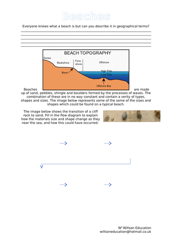
Everyone knows what a beach is but can you descibe on ein geographical terms? Beaches are made up of sand, pebbles, shingle and boulders formed by the processes of waves. The combination of these are in no way constant and contain a verity of types, shapes and sizes.
This worksheet helps students to define a beach using geographical terms and explain how the materials size and shape change as they near the sea, and how this could have occurred
This coastal assessment is made up of two parts:
Part One - Produce an educational leaflet for the Dorset Tourist Board to give to secondary school teachers who bring school groups to the Swanage Bay area.
Part Two - Decision Making Exercise - The Swanage Borough Council is considering a proposal to build a marina across a part of Swanage Bay.
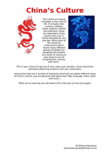
The culture of a group of people is their way of life. It includes their customs, hobbies, foods, fashions, beliefs and traditions; these are dependent of the country they live in, family background, sex and age. Many parts of the world are multicultural which means many different groups of people live alongside one another as a result of moving to new areas to live ad bringing their cultures with them.
This is a chance for your students to get out of your seats and, sensibly, move around the classroom gathering evidence with their classmates to learn about China's culture.
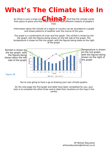
As China is such a large country it’s not surprising to find that the climate varies from place to place and that these variations have different impacts of people’s lives.
These worksheets help students to understand climate graphs, how to read ad draw them. They also give them a chance to develop their own graph and peer mark eachothers ideas with supporting comments.
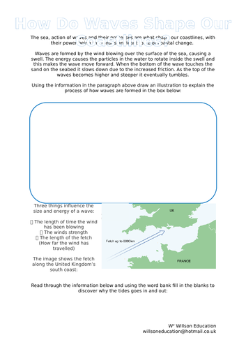
The sea, action of waves and their processes are what shape our coastlines, with their power being the most significant force of coastal change. These worksheets look at the swell, the fetch and how tides are formed.
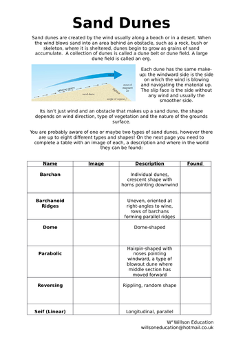
Sand dunes are created by the wind usually along a beach or in a desert. When the wind blows sand into an area behind an obstacle, such as a rock, bush or skeleton, where it is sheltered, dunes begin to grow as grains of sand accumulate.
This worksheets helps students to understand how sand sunes are formed, their make up and the eight different types of dunes and where they are found around the world.
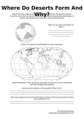
Believed to have been living in the Kalahari Desert for over 80,000 years, the San People are thought to be the world’s most ancient race. This independent research-based lesson helps the students to develop their understanding of life and surviving in a harsh environment.
Please like and follow us on Facebook @WillsonEducation or Pinterest @willsoned for more exciting resources, activities, and upcoming events to incorporate into your lessons.
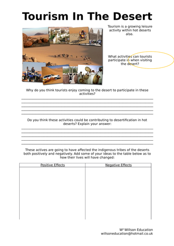
Tourism within deserts is an increasing economic activity with many positive and negative impacts on those tribes people who call these areas home. These worksheets have the students disgussing these impacts and go on to develop a logo and slogan for a company which advertises that it takes these impacts into consideration while promoting tourism activities within deserts.
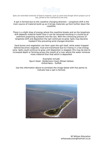
Spits are extended stretches of beach material, such as sand and shingle which project out to sea, joined to the mainland at one end. A spit is formed due to the coastline changing direction – Longshore drift is the main source of material build up as it brings materials up from further down the coastline.
These worksheets look at how spits are formed and the processess, inputs and outputs of spits.
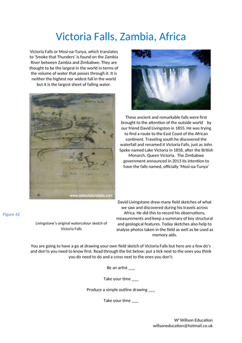
Victoria Falls or Mosi-oa-Tunya, which translates to ‘Smoke that Thunders’ is found on the Zambia River between Zambia and Zimbabwe. They are thought to be the largest in the world in terms of the volume of water that passes through it. It is neither the highest nor widest fall in the world but it is the largest sheet of falling water.
This worksheet helps your students to understand the dos and don’ts of field sketching. Victoria Falls is used as an example to help practice this important skill
This unit of work encourages students to appreciate the links between music and Geography, why it is popular, the many genres it entails and how it is used around the world.
Traditions from Brazil, China, England, India, and Russia are investigated for their similarities in instruments, dances, and festivals. Music as an economic activity is explored, in addition to festivals in the United Kingdom and why they may be located where they are. Local venues to the students, both indoors and outdoors, are investigated for their sustainability for hosting a music festival.
The unit concludes with the students designing a brand and logo for a sustainable music festival at their school. The final designs are then peer assessed.
A range of individual and group activities are incorporated within this booklet, including, gathering research from print, annotating maps, students own thoughts and ideas, calling on their local knowledge and effectively assessing other work.
Please like and follow us on Facebook @WillsonEducation or Pinterest @willsoned for more exciting resources, activities, and upcoming events to incorporate into your lessons.
This 32 page booklet gives students the opportunity to explore the FIFA World Cup, Russia and their connections to geography using different Geographical themes and skills. Chapters include:
Why Is Football So Popular?
How Is Football Linked To Geography?
Who Are FIFA?
Who’s Taking Part In 2018?
Friendly Rivals
We Are Number One!
Football As An Economic Activity
Flag Crossword
Getting The Vote
What Do You Know About Russia?
Where In Russia?
Population And Nationality
Country Climate
Seeing The Sites
What Have We Borrowed?
Build A Brand
Knowing The Neighbours
Football Acrostic
How Is This Omar Linked To Football?
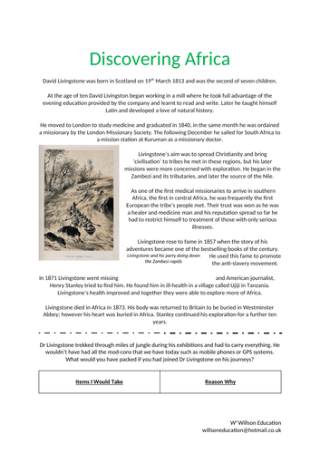
As one of the first medical missionaries to arrive in southern Africa, the first in central Africa, Dr Livingstone was frequently the first European the tribe’s people met. Their trust was won as he was a healer and medicine man and his reputation spread so far he had to restrict himself to treatment of those with only serious illnesses.
These worksheets look at Dr Livingstone travels to Africa, the students discuss what they would have packed to take with them, how they would have traveled there and the discoveries made there and how they would have helped the British Empire.
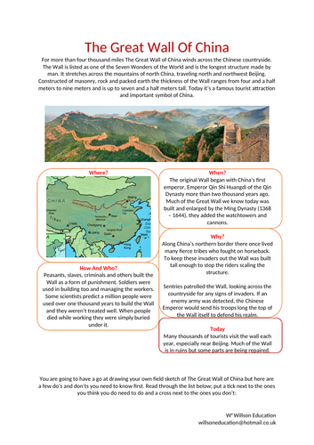
For more than four thousand miles The Great Wall of China winds across the Chinese countryside. The Wall is listed as one of the Seven Wonders of the World and is the longest structure made by man. It stretches across the mountains of north China, traveling north and northwest Beijing. Constructed of masonry, rock and packed earth the thickness of the Wall ranges from four and a half meters to nine meters and is up to seven and a half meters tall. Today it’s a famous tourist attraction and important symbol of China.
These worksheets help your students develop their field sketching skills by explaining the dos and don’ts and using the Great Wall of China as an example
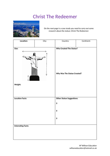
Looking over Rio De Janeiro from the 704 meter summit of Corcovado Mountain in the Tijuc Forest National Forest, the statue of Chris the Redeemer stands as a symbol of Brazilian Christianity. A Catholic priest, named Pedro Maria Boss, suggested the idea of a religious monument being built in 1850.
These worksheets help your students to carry out a case study of the statue, giving you the opportunity of giving them the additional sheet of information or allowing them to carry out their own research.
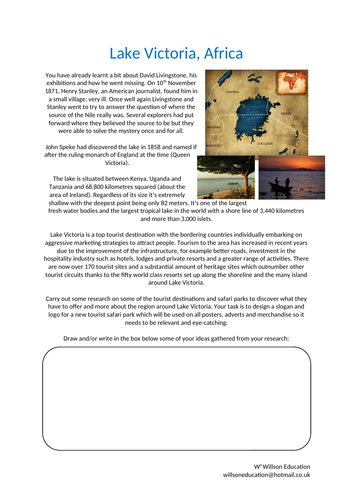
Lake Victoria is situated between Kenya, Uganda and Tanzania and 68,800 kilometres squared (about the area of Ireland). Regardless of its size it’s extremely shallow with the deepest point being only 82 meters. It’s one of the largest fresh water bodies and the largest tropical lake in the world with a shore line of 3,440 kilometres and more than 3,000 islets.
Lake Victoria is a top tourist destination with the bordering countries individually embarking on aggressive marketing strategies to attract people. Tourism to the area has increased in recent years due to the improvement of the infrastructure, for example better roads, investment in the hospitality industry such as hotels, lodges and private resorts and a greater range of activities. There are now over 170 tourist sites and a substantial amount of heritage sites which outnumber other tourist circuits thanks to the fifty world class resorts set up along the shoreline and the many island around Lake Victoria.
The students task is to carry out research on some of the tourist destinations and safari parks to discover what they have to offer and more about the region around Lake Victoria. They go on to design a slogan and logo for a new tourist safari park which will be used on all posters, adverts and merchandise.
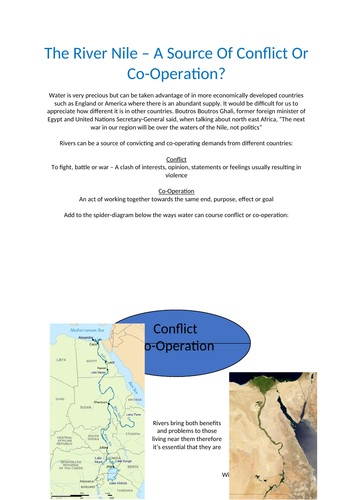
Water is very precious but can be taken advantage of in more economically developed countries such as England or America where there is an abundant supply. It would be difficult for us to appreciate how different it is in other countries. Boutros Boutros Ghali, former foreign minister of Egypt and United Nations Secretary-General said, when talking about north east Africa, “The next war in our region will be over the waters of the Nile, not politics”
Rivers can be a source of convicting and co-operating demands from different countries. These worksheets discuss the factors responsible for flooding the Nile, why the demand for water is growing in the Nile basin, the possible consequences for Egypt if water shortages arise and possible solutions.
The advantages and disadvantages of living upstream or downstream of a possible dam are discussed, as well as whether developing the land at risk of flooding should be allowed and concludes with who owns the water in the worlds major world rivers.
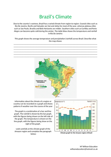
Due to the country’s vastness, Brazil has a varied climate from region to region. Coastal cities such as Rio De Janeiro, Recife and Salvador are hot and sticky for most of the year, whereas plateau cities such as Sao Paulo, Brasilia and Belo Horizonte are milder. Southern cities such as Curitiba and Porto Alegre can become quite cold during the winter.
This worksheet helps students to be able to read climate graphs as well as draw and describe them.