I've worked in primary teaching for over 10 years and specialise in creating fun and engaging educational resources, particularly for Geography and History.
I've worked in primary teaching for over 10 years and specialise in creating fun and engaging educational resources, particularly for Geography and History.
This lesson is part of Investigating Rivers, a unit designed for upper KS2 (Y4-6).
It challenges students to think about all the different ways we use water and where we get it from. Are these necessary (needs) or luxury (wants)?
Students then categorise these uses of water as agricultural, recreational, commercial/industrial or community. Lastly, they consider how we can balance human water requirements with those of Earth’s wildlife.
In the activity students sort photos of different water uses into six different categories:
Household
Commercial/industrial
Recreational
Agricultural
Community
Wildlife
In the extension activity, students classify each water use as either necessary or luxury and explain their reasoning.
If you like this resource, we would appreciate a review! We will happily send you a free resource in return for a review or useful suggestions/feedback. Contact us at ed@teachitforward.co.uk.
This lesson is part of Understanding Trade, a Geography unit designed for students in upper KS2 (Y5-6).
The presentation first asks students to think about how the products we buy arrive in the shops. It then introduces the concept of supply chains. To explain this concept, students look at the processes involved in the production of milk.
There are two activities:
Group Activity:
Students sort and sequence four mixed up supply chains including those of bananas, T-shirts, bookshelves and coffee.
Individual Activity:
Students sequence the supply chains of bananas, T-shirts, bookshelves and coffee.
Easier – Students sequence supply chains (first and last process given)
Harder – Students sequence supply chains (no clues)
If you like this resource, we would appreciate a review! We will happily send you a free resource in return for a review or useful suggestions/feedback. Contact us at ed@teachitforward.co.uk.
This lesson is part of Our World, a Geography unit designed for students in KS1 and lower KS2 (Y1-3), but can also be taught as a stand alone lesson.
It aims to help younger students understand where they live. It looks at where Earth is in the solar system and then which continent, country and place they call home.
In the activity students write sentences about where they live. There are two differentiated worksheets:
Easier – Students fill in cloze procedure sentences to describe where they live.
Harder – Students write full sentences to describe where they live.
Extension – Students sort the names of countries, continents and planets into the correct categories.
If you like this resource, we would appreciate a review! We will happily send you a free resource in return for a review or useful suggestions/feedback. Contact us at ed@teachitforward.co.uk.
This lesson is part of Understanding Trade, a Geography unit designed for students in upper KS2 (Y5-6).
First the presentation helps students understand what trade is and introduces the concepts of imports and exports. It does this by linking these ideas to every day products we buy. It also looks at the different scales of trade – local, national and international.
The activity then challenges students to match up products with statements about the company which makes them and where they are produced/manufactured.
Easier – Match the products to the statements (on stickers)
Harder – Match the products to the statements (written)
Extension – Students complete a cloze procedure paragraph about trade.
If you like this resource, we would appreciate a review! We will happily send you a free resource in return for a review or useful suggestions/feedback. Contact us at ed@teachitforward.co.uk.
This lesson is part of Mountain Environments, a Geography unit designed for students in upper KS2 (Y4-6).
N.B. Ideally students have a grounding in latitude and longitude prior to this lesson. The unit Understanding Latitude & Longitude is an ideal introduction to the topic.
First the presentation introduces students to latitude and longitude and goes through how to find the coordinates of a point step-by-step. It then asks students to find the latitude and longitude of several world capital cities.
The activity and extension then challenge children to locate famous world mountains using their latitude and longitude:
Easier - Students locate 12 famous world mountains using latitude and longitude.
Harder - Students locate 16 famous world mountains using latitude and longitude.
Extension - Students add more famous mountains to their world map using latitude and longitude clues.
If you like this resource, we would appreciate a review! We will happily send you a free resource in return for a review or useful suggestions/feedback. Contact us at ed@teachitforward.co.uk.
This lesson is part of Exploring Spain, a Geography unit designed for upper KS2 students (Y4-6), but can also be taught as a stand alone lesson.
The presentation first recaps the climate zones of the world (i.e. tropical, temperate & polar zones) and locates Spain within these.
It then looks in more detail at Spain’s weather, climate zones and the climate of Madrid. Students are then encouraged to find clues about Madrid’s weather using a climate graph.
This lesson includes two activities:
Comprehension activity:
Students interpret climate graphs for Madrid and London and compare the climates of both cities.
ICT activity:
Students create their own climate graph for Madrid using Microsoft Excel.
If you like this resource, we would appreciate a review! We will happily send you a free resource in return for a review or useful suggestions/feedback. Contact us at ed@teachitforward.co.uk.
This lesson is part of The Seaside, a Geography unit designed for students in KS1 and lower KS2, but can also be taught as a stand alone lesson.
The presentation takes students on a tour of the seaside town of Lyme Regis, home of the famous 19th century paleontologist, Mary Anning.
On the way, students find out about a variety of tourist attractions and other features including the harbour, the Marine Aquarium and the Lyme Regis Museum.
The activity then challenges students to use their map skills to locate these features on a map of the town.
Easier - Students identify each feature of Lyme Regis by writing a number.
Harder - Students identify each feature of Lyme Regis by writing a name.
Extension - Students locate and circle other features of Lyme Regis using the map key.
If you like this resource, we would appreciate a review! We will happily send you a free resource in return for a review or useful suggestions/feedback. Contact us at ed@teachitforward.co.uk.
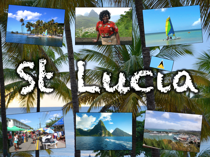
Exploring St Lucia is a Geography unit designed for students in KS2.
As a tropical island in the Caribbean, St Lucia is great for teaching about a contrasting non-European country.
The planning overview, topic title page and vocabulary page can be downloaded for free here. Lessons include:
L1 – Locating St Lucia in the Caribbean
L2 – Identifying the human and physical features of St Lucia
L3 – Investigating satellite photos of St Lucia
L4 – Using compass directions to locate places in St Lucia
L5 – Comparing the weather of St Lucia and the UK
L6 – Comparing St Lucia with the UK
Each lesson includes a presentation and differentiated activities/worksheets.
If you like this resource, we would appreciate a review! We will happily send you a free resource in return for a review or useful suggestions/feedback. Contact us at ed@teachitforward.co.uk.
This lesson is part of The Seaside, a Geography unit designed for students in KS1 and lower KS2, but can also be taught as a stand alone lesson.
The presentation introduces students to the seaside topic and then challenges them to identify features of the seaside (e.g. sandcastle, lifeguard) from partial picture clues.
In the activity, students identify and label seaside features:
Easier – Students label photos of seaside features (with initial letter clues).
Harder – Students label photos of seaside features (no clues)
Extension:
Easier – Students label seaside features in photos of Brighton Beach and a beach on the Isle of Harris.
Harder - Students write sentences about seaside features in photos of Brighton Beach and a beach on the Isle of Harris.
If you like this resource, we would appreciate a review! We will happily send you a free resource in return for a review or useful suggestions/feedback. Contact us at ed@teachitforward.co.uk.
This lesson is part of Investigating Rivers, a unit designed for upper KS2 (Y4-6).
Students are first introduced to the three stages of a river – the upper course, middle course and lower course – and some of the key features of each. The presentation then challenges students to think about the characteristics of rivers in these different stages (e.g. altitude, channel width, water speed).
In the activity, students match descriptions to each stage of a river. It is differentiated two ways:
Easier – Students match colour-coded descriptions to either the upper, middle or lower course of a river.
Harder – Students match descriptions to either the upper, middle or lower course of a river.
If you like this resource, we would appreciate a review! We will happily send you a free resource in return for a review or useful suggestions/feedback. Contact us at ed@teachitforward.co.uk.
This lesson is part of Our World, a Geography unit designed for students in KS1 and lower KS2 (Y1-3), but can also be taught as a stand alone lesson.
The presentation first helps students understand the concepts of ‘human’ and ‘natural’. It then takes them on a journey around the world and challenges them to identify human and natural features of our planet (e.g. mountains, airports).
There are two associated activities:
Group activity:
Students match pictures of features of the world to their names and sort them into human and natural categories.
Individual activity:
Children identify photos of features of the world.
Easier – Students identify features of the world (no writing).
Harder – Students identify features of the world (writing).
Extension – Students label each feature as human (H) or natural (N).
If you like this resource, we would appreciate a review! We will happily send you a free resource in return for a review or useful suggestions/feedback. Contact us at ed@teachitforward.co.uk.
This lesson is designed for KS2 children. It can be taught as a stand alone lesson but is also available as part of two wider units, both of which are available on TES:
-Earthquakes
-Volcanoes & Earthquakes
The presentation looks at three famous earthquakes from the previous decade including Haiti (2010), New Zealand (2011) and Japan (2011).
The activity then challenges students to research an earthquake online (e.g. Simple Wikipedia) and write a fact file about it. A completed fact file about the earthquake in Christchurch in 2011 is included as an example.
Easier – Students research and create a fact file about their chosen earthquake.
Harder – Students research and create a fact file about their chosen earthquake plus insert a map and add photo captions.
If you like this resource, we would appreciate a review! We will happily send you a free resource in return for a review or useful suggestions/feedback. Contact us at ed@teachitforward.co.uk.
This lesson is part of Exploring Spain, a Geography unit designed for upper KS2 students (Y4-6), but can also be taught as a stand alone lesson.
The presentation first shows students how to work out a 4-figure grid reference.
The activity then challenges students to describe the position of different cities in Spain using 4-figure grid references. It is differentiated two ways:
Easier – Students locate Spanish cities using 4-figure grid references (with clues).
Harder – Students locate Spanish cities using 4-figure grid references.
Extension – Students identify Spanish cities using compass direction and grid reference clues.
If you like this resource, we would appreciate a review! We will happily send you a free resource in return for a review or useful suggestions/feedback. Contact us at ed@teachitforward.co.uk.
This lesson is part of Exploring Spain, a Geography unit designed for upper KS2 students (Y4-6), but can also be taught as a stand alone lesson.
In the presentation students embark on a tour of Madrid, learning interesting facts about Spain’s capital city along the way. They visit sites including the famous Royal Palace, the Sun Gate and the Santiago Bernabeú Stadium, home of Real Madrid.
The lesson has two activities:
Quiz activity:
Students use an online encyclopedia to answer questions about Madrid.
Guided tour writing activity:
Students give their very own guided tour of Madrid.
Easier – Students write a guided tour of Madrid using a writing frame.
Harder – Students write a guided tour of Madrid by sticking images into their exercise books.
If you like this resource, we would appreciate a review! We will happily send you a free resource in return for a review or useful suggestions/feedback. Contact us at ed@teachitforward.co.uk.
This resource is part of Tropical Rainforests, a Geography unit designed for students in KS2, but can also be taught as a stand alone lesson. All resources are compatible with both Microsoft Office and Google Workspace.
This comprehension activity is based on the BBC’s My World Amazon Special. It is a great way for students to learn more about the effect of deforestation on a native Amazon tribe, the Arara.
It also introduces students to other key groups with an interest in the Amazon including a ranching family, student protestors and a conservationist.
In the activity, students answer questions about the documentary:
Easier - Students answer comprehension questions with time hints to help them find answers in the video.
Harder - Students answer comprehension questions with no time hints.
A transcript of the documentary is also included in case computers are in short supply.
If you like this resource, we would appreciate a review! We will happily send you a free resource in return for a review or useful suggestions/feedback. Contact us at ed@teachitforward.co.uk.
This lesson is part of Exploring the United Kingdom, a Geography unit designed for KS1 and lower KS2 (Y2-4).
The presentation first introduces students to satellite photos before going on to challenge them to match satellite photos to famous UK landmarks (e.g. Wembley Stadium, Edinburgh Castle).
In the activity, students use their geography detective skills to describe satellite photos and infer which famous UK landmark or feature each one is. It is differentiated two ways:
Easier – Students write description of each satellite photo on a writing template sheet.
Harder – Students stick satellite photos into their exercise book and write descriptions next to them.
If you like this resource, we would appreciate a review! We will happily send you a free resource in return for a review or useful suggestions/feedback. Contact us at ed@teachitforward.co.uk.
This lesson is part of Understanding Trade, a Geography unit designed for students in upper KS2 (Y5-6).
First the presentation asks students to consider how everyday products arrive in our supermarkets. It then introduces and explains the concept of supply chains, looking specifically at the chocolate supply chain. There are two activities:
Group Activity:
The group activity challenges students to order the chocolate supply chain.
Writing Activity:
An accompanying writing activity is based on ‘The Story of Our Chocolate Journey’ (available on YouTube). It challenges students to sequence and explain the processes involved in the chocolate supply chain. It is differentiated three ways:
Easier – Students use a writing frame.
Harder – Students write in an exercise book using a vocabulary prompt.
If you like this resource, we would appreciate a review! We will happily send you a free resource in return for a review or useful suggestions/feedback. Contact us at ed@teachitforward.co.uk.
This lesson is part of a wider unit called Exploring St Lucia and is designed to teach KS2 students about a contrasting non-European country.
It first introduces students to the tropical climate zone and its associated weather (i.e. high temperatures, high rainfall, dry and wet seasons) and compares this with temperate climates such as that of the UK.
Students are then encouraged to interpret data from a climate graph for St Lucia. Finally, other aspects of a tropical climate are covered including tropical storms and hurricanes.
The accompanying true or false activity helps children to recap what they have learned about the climates of St Lucia and the UK. It is differentiated two ways:
Easier – Students have 6 true or false statements.
Harder – Students have 10 true or false statements.
Extension – Students complete a cloze procedure text about St Lucia’s weather and climate.
If you like this resource, we would appreciate a review! We will happily send you a free resource in return for a review or useful suggestions/feedback. Contact us at ed@teachitforward.co.uk.
This lesson is part of The Seaside, a Geography unit designed for students in KS1 and lower KS2, but can also be taught as a stand alone lesson.
The presentation introduces students to the Isles of Scilly, which lie off the south-west coast of the UK. Students then get to find out what it’s like to live on an island with Zoe and Isaac, two children who live on Bryher.
The activity then challenges students to think about the differences between life on the Isles of Scilly and life on the mainland.
Easier - Students sort 8 statements describing life on the Isles of Scilly and life on the mainland.
Harder - Students sort 14 statements describing life on the Isles of Scilly and life on the mainland.
Extension - Can students think of their own statements to write in each column?
If you like this resource, we would appreciate a review! We will happily send you a free resource in return for a review or useful suggestions/feedback. Contact us at ed@teachitforward.co.uk.
This lesson is part of The Seaside, a Geography unit designed for students in KS1 and lower KS2, but can also be taught as a stand alone lesson.
The presentation introduces students to islands, including these basic points:
Islands can be found in rivers, lakes or seas/oceans.
Islands can be found in hot and cold parts of the world.
Islands can vary in size from very small to very large (e.g. the British Isles).
The activity then challenges students to use their map skills to locate islands of the United Kingdom. This can be done using an atlas or the prompt maps included.
Easier - Students use the map prompt to identify 12 islands of the UK (using labels).
Medium - Students use the map prompt to identify islands of the UK (writing in the names).
Harder - Students use an atlas to identify 12 islands of the UK (writing in the names).
Extension - Students complete a cloze-procedure paragraph about islands.
If you like this resource, we would appreciate a review! We will happily send you a free resource in return for a review or useful suggestions/feedback. Contact us at ed@teachitforward.co.uk.