The lesson contains:
knowledge rich starter
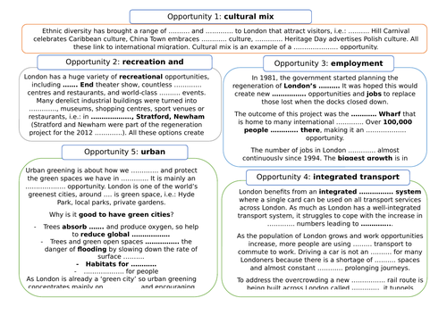
meaning of social, economic and environmental opportunities
information sheets for: cultural mix, urban greening, integrated transport system, employment, recreation and entertainment
fill in gaps worksheet to cover all five opportunities
exam type question with success criteria: explain
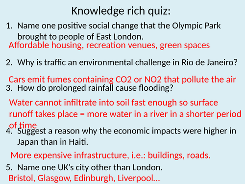
knowledge application end of lesson quiz
Enjoy teaching
The lesson contains:
knowledge rich starter
key terminology
guided reading task to cover water and energy
fill in task to cover waste recycling and transport
‘explain’ exam question with success criteria
end of lesson knowledge application quiz
All resources included.
Enjoy teaching
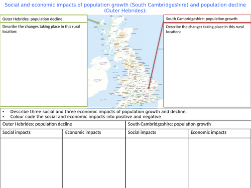
The worksheet focuses on population growth and decline in rural areas and on social and economic implications of those changes.
It goes with GCSE 9-1 Geography AQA by Oxford University Press textbook p.242-243
Hope you find it useful.
The lesson covers key idea 5.5 detailed content a, b and c of the Edexcel A level specification. The PPT is based on two textbooks:
Edexcel A level book 2 by Hodder Education referred to as ‘flags textbook’
Geography for Edexcel A level year 2 by Oxford University Press referred to as ‘dragon textbook’
The whole key idea is covered within one PPT, instructions and resources are withing the PPT, the lesson ends with an exam question taken from Edexcel A Level Geography past papers.
Enjoy teaching
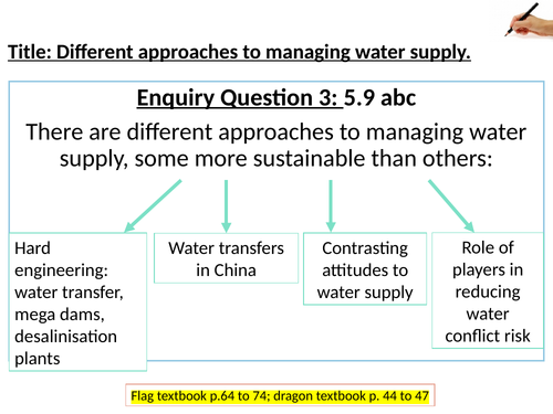
The lesson covers key idea 5.9 detailed content a, b and c of the Edexcel A level specification. The PPT is based on two textbooks:
Edexcel A level book 2 by Hodder Education referred to as ‘flags textbook’
Geography for Edexcel A level year 2 by Oxford University Press referred to as ‘dragon textbook’
The whole key idea is covered within one PPT, instructions and resources are withing the PPT, the lesson ends with an exam question taken from Edexcel A Level Geography past papers.
Enjoy teaching
The lesson introduces fieldwork to students. Focuses on setting the enquiry question and hypotheses.
All resources are included in the PPT.
Enjoy teaching
The lesson concentrates on collecting data using a transect lines and then comparing different areas of school. The lesson is based on my school but that can be quickly changed into yours.
Students present data using scatter and radar graphs.
All resources needed are included in the PPT or attached.
Enjoy teaching
Those two lessons were prepared for Y9 as part of a Superpower Unit to introduce Russia’s location, physical features and dominance on the sources of energy market.
They fulfill the aspect of Russia in the national curriculum.
All resources and complete PPTs are included. The atlas that the instruction refer to is Collins Student Atlas.
Enjoy teaching
The lesson was made for Y9. It is part of a Superpower unit.
The lesson covers the history of Tibet and explanation of its relation with China.
All resources are in the PPT.
Enjoy teaching
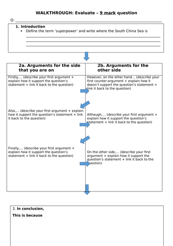
The lesson is part of a Superpower unit made for Y9 students.
This lesson covers the importance of the South China Sea to China’s economy and teaches the kids how to answer and ‘evaluate’ 9 mark question.
The atlas that one task refers to is the Collins Student Atlas but any other with a map of the South China Sea will do.
All resources are included in the PPT and one is attached as a Word document.
Enjoy teaching
A set of 12 lessons (PPTs and worksheets within PPTs) and scheme of work on Glaciation aimed at KS3 students. All worksheets/ photos/ graph outlines are included within PPTs.
lesson 1: What are glaciers?
lesson 2: Ice age and the UK
lesson 3: How does glacier move?
lesson 4: What do glaciers do? erosion, transportation and deposition
lesson 5: Corrie: characteristics and formation
lesson 6: Arete and pyramidal peak: characteristics and formation
lesson 7: U-shaped valley: characteristics and formation; ribbon lake, hanging valley, truncated spur and misfit river are also mentioned
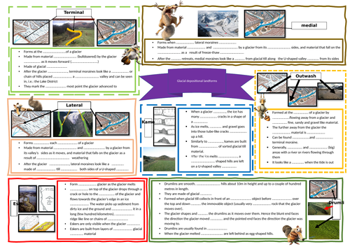
lesson 8: Depositional landforms: terminal, medial and lateral moraines, kames, eskers, drumlins and erratics
lesson 9: importance and results: why glaciers are important and what the potential results may be/are as they retreat
lesson 10: Lake District: economic opportunities and social, economic and environmental challenges
lesson 11: Lake District management: how the Lake District is managed to keep up with the ever growing tourists number
lesson 12: Svalbard: opportunities and challenges
Feel free to message me if you have any questions about these resources.
Lesson designed for KS3. All resources are in the PPT.
The lesson cover the following aspects:
types of moraines
drumlins
kames
eskers
erratics
assessment type question ‘label’
Enjoy teaching.
KS3 lesson. All resources are in the PPT.
The lesson covers the following aspects:
Reasons why areas like the Lake District should be managed
Strategies used to manage the challenges in the Lake District
Evaluation of management strategies
Enjoy teaching
This lesson covers:
knowledge rich quiz at the start
key terminology
differences between continental and oceanic crust
conservative, constructive, collision and destructive plate boundaries
processes operating at those plate boundaries
landforms created at each type of plate boundary
hazards presents at each plate boundary
exam type questions: ‘outline differences’ and ‘explain’
All resources are in the PPT.
The lesson contains:
knowledge rich starter
picture description of cave, arch, stack and stump
creation of pop up headland
explanation of the sequence of headland erosion
putting diagrams in order to consolidate the understanding of the sequence
assessment type question: explain (with answer outline)
end of lesson quiz
All resources needed are attached or included in the PPT.
All paper resources are provided
L1: question and hypotheses
L2: sampling and land use
L3: questionnaire
L4: transect line and litter pollution
L5: students own fieldwork
L6: infiltration fieldwork
Enjoy teaching
The lesson contains the following:
knowledge rich quiz as a starter
definition of meanders and ox-bow lakes
characteristics of both
sequence of formation
progress check
cross section of a meander
GCSE type question ‘explain’
end of lesson quiz
All resources are in the PPT.
Enjoy teaching
The bundle contains three knowledge tests, two for rivers (case study of a river valley and river processes) and one for urban challenges related to megacities. Each knowledge test has a feedback PPT for self or peer-assessment to save you time and at the same time check students knowledge.
Those lessons are part of the Superpower Unit made for Y9:
L1: Russia: location and physical features
L2: Russia: energy resources
L3: China: location and physical features
L4: China: population: research lesson
L5: China: Tibet
L6: China: the South China Sea
L7: China and the British Empire
Those lessons have a variety of tasks: map work, research, video, reading comprehension, explain, evaluate, describe questions.
My students loved them.
Enjoy teaching