Hero image

GeographyFocus Shop

Average Rating4.55
(based on 40 reviews)

I am a geography teacher with 36 years experience in Years 7 to 12 in high schools in New South Wales and Western Australia. I am now retired but maintain a strong interest in producing resources for the subject for which I have a passion. This shop features a range of geography resources suitable for upper primary school and high school. Free resources are available for you to use within your school to trial the quality of my work.

121Uploads

89k+Views

8k+Downloads

I am a geography teacher with 36 years experience in Years 7 to 12 in high schools in New South Wales and Western Australia. I am now retired but maintain a strong interest in producing resources for the subject for which I have a passion. This shop features a range of geography resources suitable for upper primary school and high school. Free resources are available for you to use within your school to trial the quality of my work.
Megacities Wordsearch
swintrekswintrek

Megacities Wordsearch

(0)
This word search or word maze is a fun way for your students to become familiar with the megacities of the world. An answer key is provided.
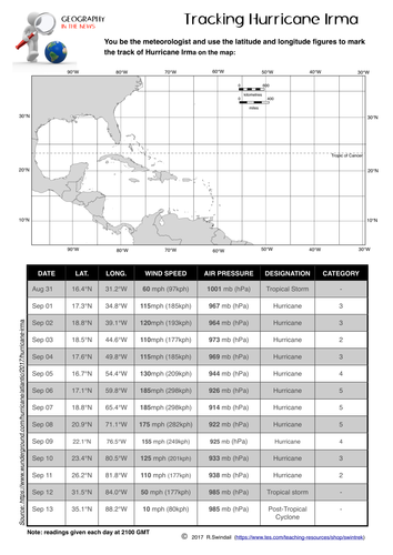
Hurricane Beryl 2024 - a latitude/longitude exercise
swintrekswintrek

Hurricane Beryl 2024 - a latitude/longitude exercise

(0)
A simple worksheet that requires your students to plot the path using latitude and longitude of Hurricane Beryl as it made its way from the mid-Atlantic to the US coast in Texas in July 2024. A larger map is on the second page which your students may find easier to work with. An answer key is provided. A good way to practice your students in plotting points using latitude and longitude, at the same time getting them to understand the relevance of this simple geographic skill to the real world. GEOGRAPHY IN THE NEWS - making the world of Geography come alive for your students.
Passage of a Cold Front - eastern Australia 2015
swintrekswintrek

Passage of a Cold Front - eastern Australia 2015

(0)
This is a one page worksheet that shows a cold front passing across Eastern Australia in July 2015. The questions ask students to interpret the weather map and to explain the cold front and associated polar vortex that brought snow as high as Queensland in Eastern Australia. Requires some internet research.
Name that Monument/Building - a place geography exercise
swintrekswintrek

Name that Monument/Building - a place geography exercise

(0)
A simple worksheet that asks students to identify icons of famous monuments or buildings from around the world and name the country in which they are located. Might be useful as a lesson filler/starter or homework exercise. Also could be used as a quiz night activity.
Investigating Cities - Shenzhen, China
swintrekswintrek

Investigating Cities - Shenzhen, China

(0)
This is a 4-page worksheet that gets students to investigate the city of Shenzhen in China which has grown from little more than a fishing village in the 1970s to an expanding metropolis of 11 million people today. Shenzhen is commonly known as the "Silicon Valley of China". The worksheet has some mapping questions that look at Shenzen's location and changes in land use over time, some statistics on the climate of the city, and a series of questions on the growth of the city and its impact that can be answered from the BBC News (link is provided). An answer key is provided for teachers. The worksheet would be useful for the Australian Curriculum unit on Liveability and for those jurisdictions where urban development is a focus, perhaps from lower to upper high school Geography.
Investigating Cape Town's Water Crisis
swintrekswintrek

Investigating Cape Town's Water Crisis

(0)
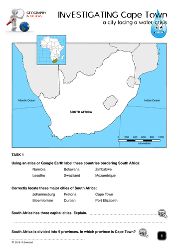
This is a five page worksheet that allows students to investigate the water crisis in Cape Town as it approaches “Day Zero”. The worksheet provides good websites that provide information on the topic as well as asking students to find their own websites. Could be useful at all levels of high school.
Climate Graph Exercises - UK Cities
swintrekswintrek

Climate Graph Exercises - UK Cities

(0)
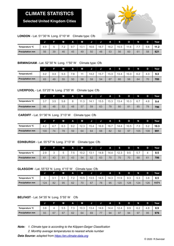
A three page set that includes: Page 1 - Tables of climate statistics for seven UK cities Page 2 - Climate graph blanks to fill in from statistics plus location map Page 3 - Complete climate graphs for teachers Cities include London, Glasgow, Edinburgh, Birmingham, Cardiff, Belfast, Liverpool
Interpreting climate graphs
swintrekswintrek

Interpreting climate graphs

(0)
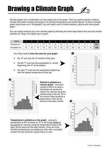
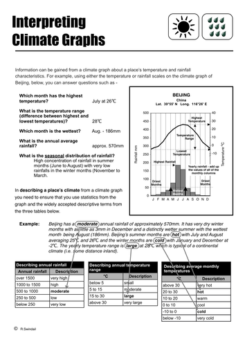
A photocopiable handout that shows students how to read information on a climate graph and put that information into a written description of the climate.
City Silhouettes - a place geography exercise
swintrekswintrek

City Silhouettes - a place geography exercise

(0)
A simple worksheet that asks students to identify the silhouettes of cities from around the world and locate them on a world map. Two exercises are presented, one for the more able students with no clues, the second with the names of the cities at the top from which students can match up with each silhouette. A blank world map is included with each exercise. An answer sheet is also provided. Might be useful as a lesson filler/starter or homework exercise. Also could be used as a quiz night activity.
Climate of London
swintrekswintrek

Climate of London

(0)
A one page worksheet that provides the climate statistics for students to construct a climate graph. Students are then to write a written description of London's climate.
Globalisation- My Place in an Interconnected World
swintrekswintrek

Globalisation- My Place in an Interconnected World

(0)
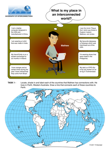
This worksheet is designed primarily for the Australian Curriculum for the topic Geographies of Interconnections but may be useful in any jurisdiction where there is a focus on globalisation from a geographic perspective. The first page is an example of a young person's connections with other countries in the world and requires students to map the countries to which that person is connected. The second page then requires the student to identify the connections he/she has with other countries in the world and then asks them to map those connections.
Climate Graphs
swintrekswintrek

Climate Graphs

4 Resources
This bundle includes two instruction sheets on how to draw a climate graph and how to interpret a climate graph. In addition the bundle includes two worksheets on the climates of two European cities: London and Rome.
Crossword Puzzle: The Water Cycle
swintrekswintrek

Crossword Puzzle: The Water Cycle

(0)
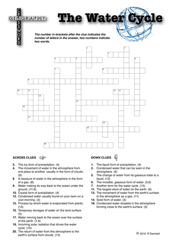
A crossword puzzle on the elements and processes within the water cycle. Three sheets: 1. Standard crossword puzzle 2. Same as standard crossword puzzle but with the first letter of each answer given as a clue. 3. Answer key A fun way for your students to learn the terms associated with the water cycle.
Australian Maps and map exercises
swintrekswintrek

Australian Maps and map exercises

(0)
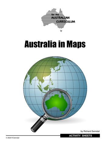
Australia in Maps is a series of worksheets based on maps of Australia showing various aspects of its Geography. The maps/worksheets include: States/Territories and their capital cities Water bodies Map 1 Water bodies Map 2 Major Urban Centres Landform Regions Natural Wonders World Heritage Sites Typical summer Weather Map Typical Winter Weather Map 10.Comparing Winter and Summer Weather Maps 11.Climate Regions 1 12.Climate Regions 2 13.Australia’s Neighbours 14.Vegetation Patterns 15.Major Rivers The package is accompanied by answers. The preview shows you the title page, one sample worksheet and one sample answer page. A great way to introduce your students to the geography of Australia!
Extreme Weather Case Study: East Coast Low - eastern Australia 4th to 6th June 2016
swintrekswintrek

Extreme Weather Case Study: East Coast Low - eastern Australia 4th to 6th June 2016

(0)
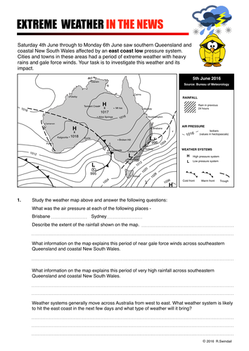
This worksheet is an extreme weather case study that gets students to investigate an east coast low pressure system that impacted the eastern seaboard of Australia between 4th and 6th June 2016 causing an immense amount of property damage as well as beach erosion and flooding in the hinterland. Students are take to the Australian Bureau of Meteorology's website where they will be able to obtain information about east coast lows and an Australian news' website where they will get information of the impact of this extreme weather event.
Investigating Hurricane Matthew - October 2016
swintrekswintrek

Investigating Hurricane Matthew - October 2016

(2)
This is a worksheet (5 pages including 2 answer pages) that will get your students to investigate Hurricane Matthew (October 2016). The first page is a latitude and longitude exercise where the students will be the meteorologist and map the track of the hurricane from September 29 through to October 8th. On the second page students will answer general questions on hurricanes as background to the third page where they will look at the impact of Hurricane Matthew more closely. An answer sheet is provided for teachers.
Tracking Hurricane Florence - a latitude/longitude exercise
swintrekswintrek

Tracking Hurricane Florence - a latitude/longitude exercise

(0)
A simple worksheet that requires your students to plot the path using latitude and longitude of Hurricane Florence as it made its way from the mid-Atlantic to the US coast in the Carolinas. An answer key is provided. A good way to practice your students in plotting points using latitude and longitude, at the same time getting them to understand the relevance of this simple geographic skill to the real world.