
39Uploads
12k+Views
3k+Downloads

The BIG Geography Quiz 2020
A fun but challenging geography themed quiz to have some fun with your classes in the build up to the festive break. All answers included at the end of the PowerPoint and a challenging ‘closest answer’ tie breaker question available to decide your quiz winner/ winning team.
This will take about 50 minutes to run through and mark. Only paper/books needed to write the answers down.
Rounds include:
Flags
Landmarks
Spot the Mistake
Geo-Politics
Christmas (Geog connection)

Enrichment - School Assembly KS3/4
10 minute assembly for key stage three and four students on enrichment and it’s importance in scecondary school.
Requires presonalisation to suit school formating and branding, as well as specific enrichment/extra-curricular opportunities at your school.
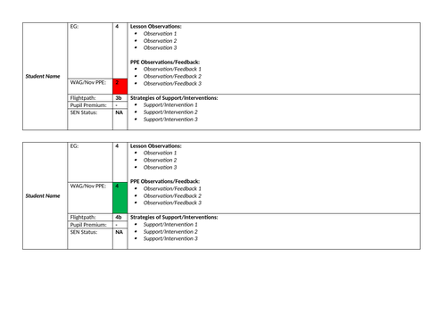
Parents Evening - Student Feedback Proforma
Template document for collating key data, observations feedback and intended strategies of support for GCSE students to raise attainment and engagement in lessons. This can then be used to feeback on a students progress during parents evenings.
Helps you to know and understand your students better, tailor your planning to meet needs more individually and demonstrate how you intend to raise achievement. Great to use as additional evidence for NQTs, supporting data during learning dialogues and learning walks.
Fields included:
Expected Grade
Working at Grade/PPE Result
Flightpath
SEN Status: Yes/No
PP: Yes/No
Lesson Observations - to gather/record how students perform/engage in lessons.
PPE Observations & Feedback - to gather record WWW and EBIs of mock exams.
Strategies of Support/Interventions - how you as the class teacher intend to support and raise student attainment.

Geography Careers Display
A full board display to demonstrate/promote the wide-ranging and varied careers that studying geography can lead to.
Included in the pack:
Title letters (will require some patient cutting out)
Career cards
QR code menu lists - links to each of the career cards and provides students with more details about the role.

Geography Map Skills Classroom Display
Full set of printable resources for a map skills display for a geography classroom.
Pack includes:
Display title lettering
Slides with key skill areas
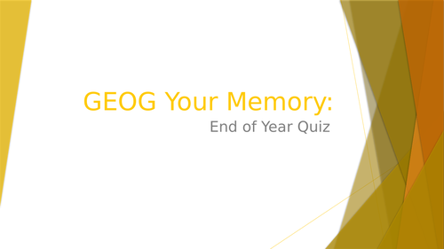
GEOGraphy Your Memory - End of Year Quiz
End of school year geography quiz to “GEOG” your memory. suitable for all ages at secondary as questions are general trivia, landmarks/buildings and obscure flags etc, no alignment to GCSE specs etc.
Rounds:
Round 1: General Trivia (20 questioins) - 20x 1 point
Round 2: Landmarks/Buildings (10 questions) - 10x 2 points, 1 for name of landmark and 1 for location
Round 3: Obscure Flags (10 questions) - 10x 1 point for name of country/territory/location
All answers provided with animation.
Total points available: 50

Map Template with Grid Lines & Key Box
A4 sized map template with grid lines and an area for a key to be added.
This ready made resource can be used for students who have just completed a basic geography skills including grid references, map symbols, contour lines etc. to put together a treasure map or something similar to and use their newly developed skills.
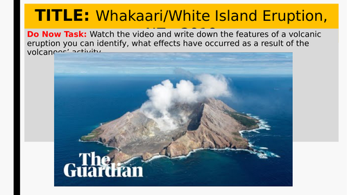
Tectonics: L9 Volcano Case Study
Case study investigation lesson that examines the Whakaari/White Island Eruption, New Zealand in 2019.
Lesson Objectives:
Students will be able to identify immediate or short-term impacts of a volcanic eruption.
Students will be able to assess the the long-term impacts of the Whakaari/White Island volcanic eruption

ECT/NQT - Teaching Standards Evidence Table
A completed table of evidence for each of the DfE Teaching Standards that you will be assessed against on a termly basis throughout your ECT or NQT year.
Each section contains examples of practice or actions taken that support the meeting of the required teaching standards, both Part 1 and Part 2.
Please update and amend the evidence column where necessary and also remove items when not applicable to yourself/or subject.

Map Skills Knowledge Organiser (Year 7)
Doubled-sided A4 knowledge organiser covering:
Existing knowledge
Keywords
Directions
Grid references
Scale
Contours
Maps (UK, Europe, World)
Area for inserting school.

Geography Keyword Keys - Display
A3 keys with important geography vocabulary inside, can be used as a display altogether or laminated and placed individually around a classroom room.
Words can also be edited to suit needs of students and the specification/SoWs of school.
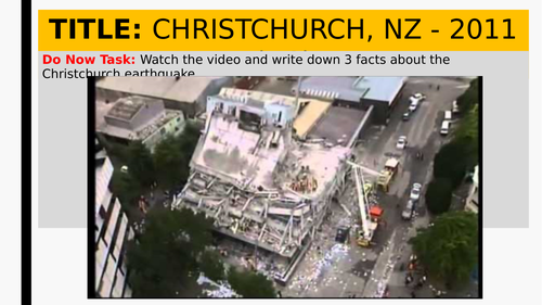
Tectonics: L5 AC Earthquake Case Study
Case study lesson of an earthquake in an AC (advanced country) - Christchurch, New Zealand 2011.
Lesson objectives:
Students will be able to identify human and physical impacts of an earthquake.
Students will be able to assess the effects of an earthquake on an AC.

Biodiversity Management in Madagascar
Case study fact file with about how biodiversity is being managed on the island of Madagascar.

Geography Facts - Display / TV / Social
Geography fact cards/slides that can be used as part of a classroom display, on TV displays around school or on departmental social media accounts.
Document can also be used as a template file and adjusted to suit school setting.

Dharavi Slum - Concept Map
Full concept map of the social, economic and environmental conditions/factors of the Dharavi slum in Mumbai, India.

Geography Skills Keyword - Word Search
A word search featuring 29 keywords from the ‘Geography Skills’ topic.
This resource is perfect as a starter or plenary activity within an introduction to geography scheme of work aimed at year 7 students or early KS3.
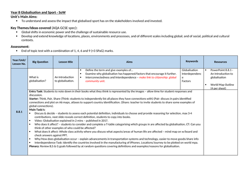
Globalisation & Sport: Unit of Work
Unit’s Main Aims:
To understand and assess the impact that globalised sport has on the stakeholders involved and invested.
Key Themes/Ideas covered (AQA GCSE spec):
Global shifts in economic power and the challenge of sustainable resource use.
Develop and extend knowledge of locations, places, environments and processes, and of different scales including global; and of social, political and cultural contexts.

Exam GCSE Question Command Words
Command words and definitions are specific to the OCR exam board.
PowerPoint document that can be used as part of a display or used during an introductory lesson to GCSE study to assist students with understanding how GCSE exam questions will be presented to them and how to go about answering.
It is noted that students who clearly identify the instructional direction of questions perform better as they produce a focused answer.

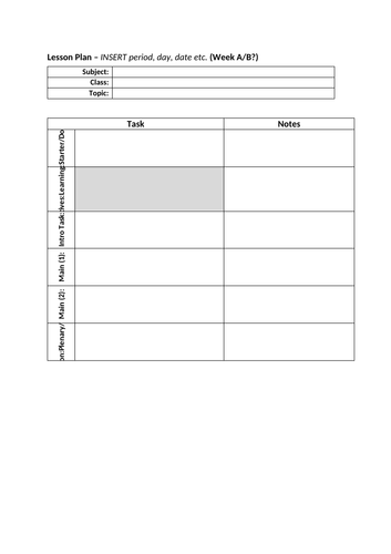
Lesson Plan - Template
Simple and easy to use lesson planning template, all fields can be amended to suit school and additional fields can be added to if your lesson features more or less activities or phases.